Post by fots2 on Jul 5, 2011 19:58:43 GMT 8
One thing for sure is that Corregidor will always have conflicting information regarding certain events or locations which cannot be verified beyond doubt. It seems that no matter how much material you cover or any source you produce, some comments will not agree. One example of this is the exact location of a 1945 battle site known as Goal Post Ridge.
Although this ridge is mentioned elsewhere there seems to be two main accounts of events involving this ridge and its location. One account comes from Paul J. Cain, Company Commander, I Co, 34th Inf. Regt. He was an officer directly involved in the action. The other account comes from Jan Valtin who was a combat reporter. By his own admission, he used second hand reports for his book. From this information alone, I know who I tend to believe but you can make up your own minds.
The Belote Brothers state on page 229 that they got their text from Valtin so I will ignore them.
Let’s examine text from both Cain and Valtin. Follow this link to read about Goal Post Ridge from Paul Cain.
24thida.com/stories_by_members/cain_paul_34th_corregidor.html
He states that "K Company on top of Malinta Hill had 2 lower areas to their left flank" (i.e. north of them). There are two hills here, one to the north is 200 feet high and one to the NE is 175 feet high. Cain says the lower of the two (the most easterly one) was Goal Post Ridge.
Also, he makes a statement about Infantry Point being 150 yards NE of his position. If understand him correctly, his position at that moment was Goal Post Ridge. From the end of Infantry Point to the top of the lower hill is about 130 yards. Infantry Point to the higher hill is about 220 yards so much farther that he states. This statement about the distance to Infantry Point reinforces the idea of the lower hill being Goal Post Ridge.
Paul Cain uses no maps in his account of this battle.
Follow this link to read about Goal Post Ridge from Jan Valtin.
rockforce.org/rock_force/valtin/valtin_01.html
On page 4 of that link, read the description about the naming of Goal Post Ridge. Jan Valtin mentions “two rises in the ground” between the guys on top of Malinta Hill and Malinta Point. (Keep these two locations in mind when you read my comments about his sketch below).
I believe he is referring to the 175 and 200 ft high hills but they are not between him and Malinta Point. He calls the taller one Goal Post Ridge. This and calling the shorter one Little Knob disagrees with Cain.
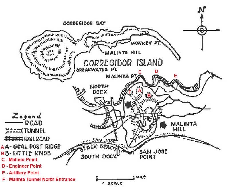
A third theory is that Goal Post Ridge actually was somewhere along the ridge between the top of Malinta Hill and Malinta Point. This idea may have come from the sketch Valtin used in his book. It is a very poor quality and geographically incorrect sketch that certainly can cause confusion.
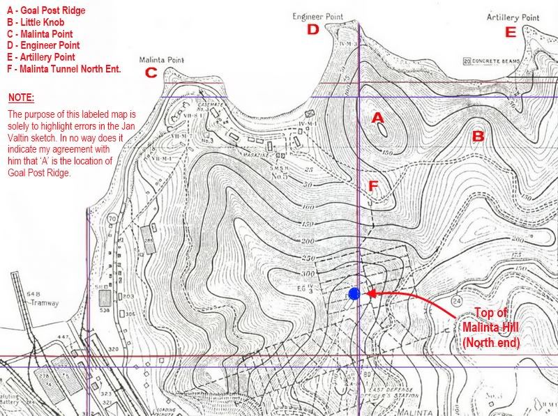
Jan Valtin’s sketch from his book. I relabelled some of it for clarity and added a few more locations. Note his ‘A’ and ‘B’ designations.
As you head east from Bottomside you do come to Malinta Point (C) first. Next is Engineer Point (D) and then Artillery Point (E).
The 200 ft high hill (A) is NOT south of Malinta Point.
The 175 ft high hill (B) is NOT between Malinta Point and Engineer Point.
The Malinta Tunnel North entrance is NOT between Bottomside and Malinta Point.
For comparison to Valtin’s sketch, here is a map showing the correct layout of all points of interest.
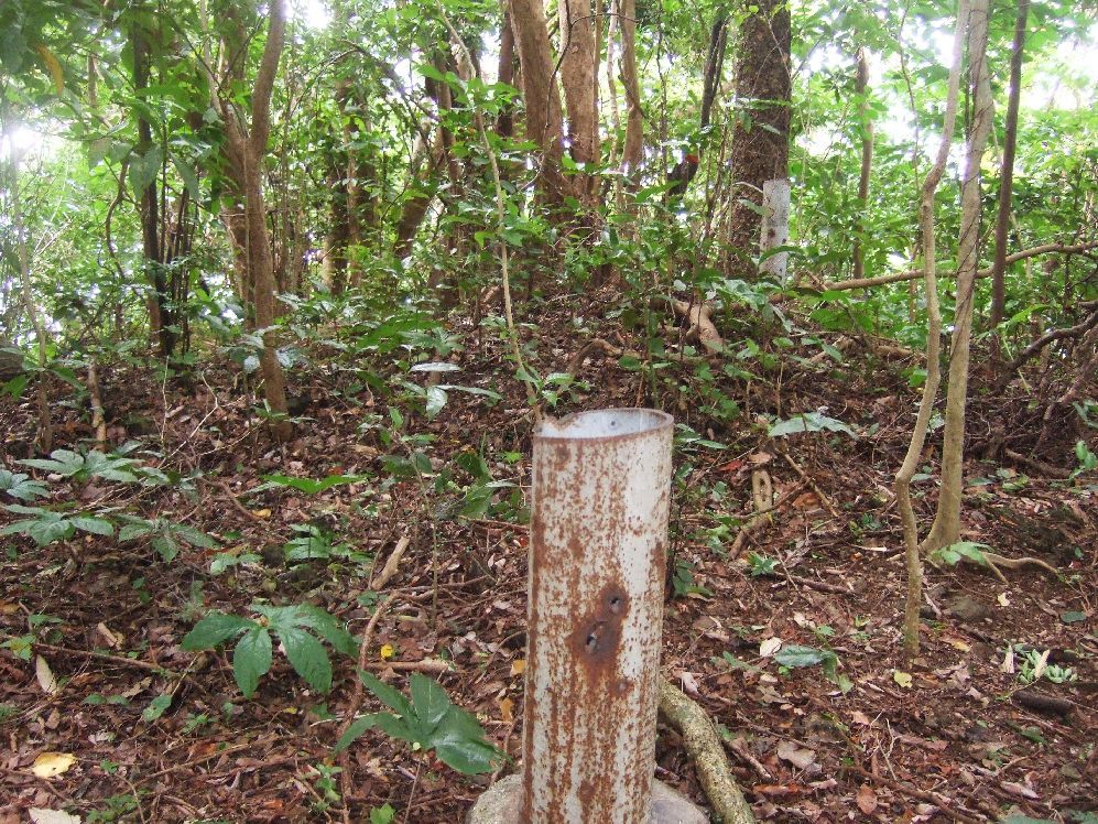
Along the ridge from the top of Malinta Hill to Malinta Point I see only one pipe. There is a piece of frayed cable on a cable anchor of some sort nearby. In my opinion, this ridge is not the area being discussed by either Cain or Valtin.
Single 3-inch pipe embedded into a larger pipe.
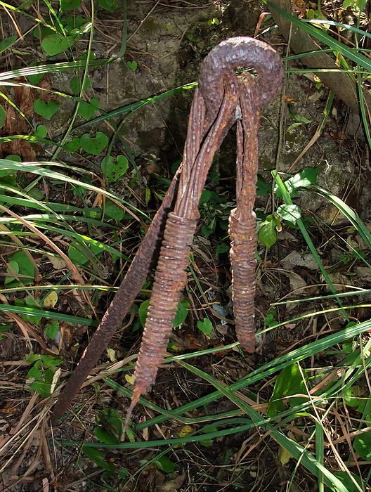
Cable anchor.
To summarize, Valtin calls the 200ft hill Goal Post Ridge and the shorter one Little Knob. Cain calls the shorter one Goal Post Ridge.
Last Saturday I walked extensively along both of these lower areas/hills. The western one at 200 ft high is narrow and steep on both sides. There are foxholes still there on top and on the side facing east. A couple foxholes are also on the north slope just before the cliff. Definitely no pipes up here.
The lower hill at 175 ft is sloped but not quite as steep on the western side. It is steeper on the eastern side which would have faced the Japanese at the time. This hill has quite a few foxholes. By far most of them are along the eastern side but I also see some on the north side and on top. The lowest positions at road level facing east are five foxholes in a row.
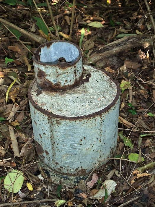
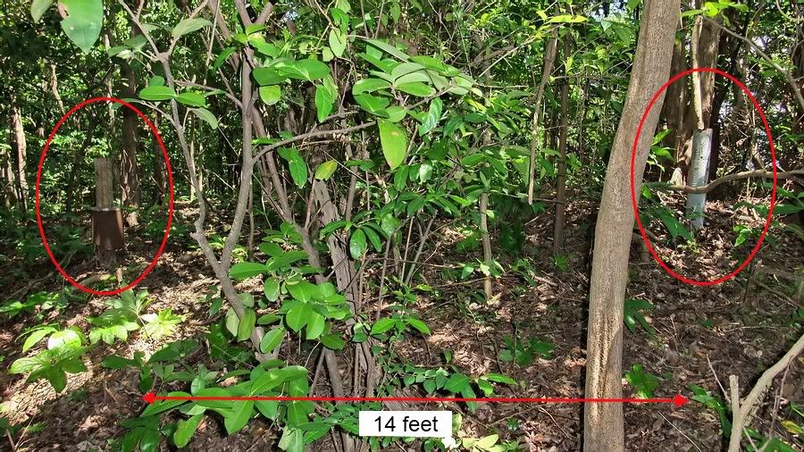
So why am I bringing up this subject now? On top of this 175 ft lower hill I see two metal 3 inch diameter pipes sticking vertically out of the ground 14 feet apart. Today they are cut off to a bit less than three feet high. I cannot say how high they were in 1945. (Scrappers may have taken these easy targets in later years). They sure look like goal posts to me. This agrees with what Paul Cain says.
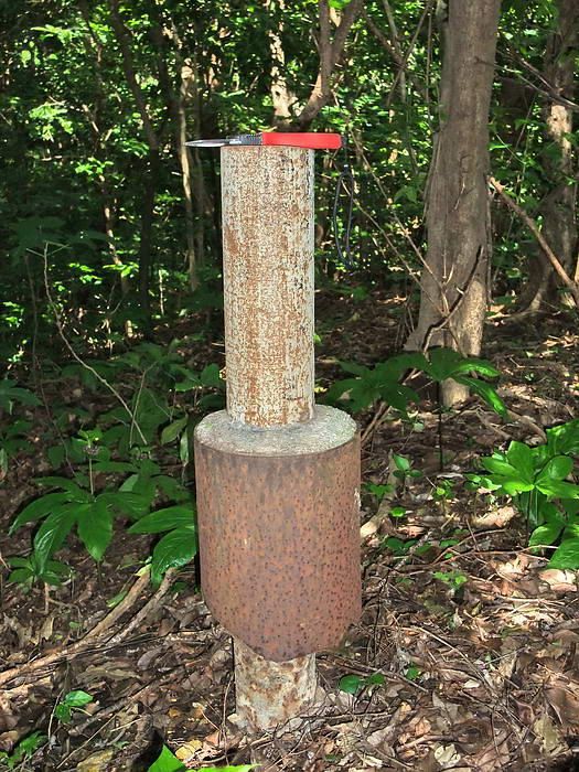
My hand cutters are on top of the pipe for a size reference. A short section of larger diameter pipe surrounds the 3 inch pipe.
My hand cutters are on top of the pipe for a size reference.
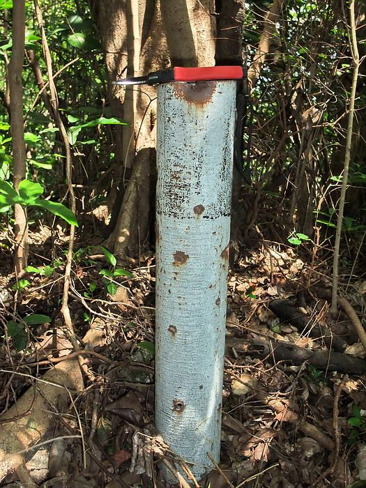
A view of both pipes. They may have been much taller in 1945. Look like goal posts?
I am trying to determine if we have enough evidence to say exactly where Goal Post Ridge was located. Finding two pipes is not conclusive evidence but strongly points to the shorter hill being our prime suspect.
If anyone has further information or even opinions about Goal Post Ridge, please feel free to add it here. Discussion makes us all think.
Although this ridge is mentioned elsewhere there seems to be two main accounts of events involving this ridge and its location. One account comes from Paul J. Cain, Company Commander, I Co, 34th Inf. Regt. He was an officer directly involved in the action. The other account comes from Jan Valtin who was a combat reporter. By his own admission, he used second hand reports for his book. From this information alone, I know who I tend to believe but you can make up your own minds.
The Belote Brothers state on page 229 that they got their text from Valtin so I will ignore them.
Let’s examine text from both Cain and Valtin. Follow this link to read about Goal Post Ridge from Paul Cain.
24thida.com/stories_by_members/cain_paul_34th_corregidor.html
He states that "K Company on top of Malinta Hill had 2 lower areas to their left flank" (i.e. north of them). There are two hills here, one to the north is 200 feet high and one to the NE is 175 feet high. Cain says the lower of the two (the most easterly one) was Goal Post Ridge.
Also, he makes a statement about Infantry Point being 150 yards NE of his position. If understand him correctly, his position at that moment was Goal Post Ridge. From the end of Infantry Point to the top of the lower hill is about 130 yards. Infantry Point to the higher hill is about 220 yards so much farther that he states. This statement about the distance to Infantry Point reinforces the idea of the lower hill being Goal Post Ridge.
Paul Cain uses no maps in his account of this battle.
Follow this link to read about Goal Post Ridge from Jan Valtin.
rockforce.org/rock_force/valtin/valtin_01.html
On page 4 of that link, read the description about the naming of Goal Post Ridge. Jan Valtin mentions “two rises in the ground” between the guys on top of Malinta Hill and Malinta Point. (Keep these two locations in mind when you read my comments about his sketch below).
I believe he is referring to the 175 and 200 ft high hills but they are not between him and Malinta Point. He calls the taller one Goal Post Ridge. This and calling the shorter one Little Knob disagrees with Cain.
A third theory is that Goal Post Ridge actually was somewhere along the ridge between the top of Malinta Hill and Malinta Point. This idea may have come from the sketch Valtin used in his book. It is a very poor quality and geographically incorrect sketch that certainly can cause confusion.
Jan Valtin’s sketch from his book. I relabelled some of it for clarity and added a few more locations. Note his ‘A’ and ‘B’ designations.
As you head east from Bottomside you do come to Malinta Point (C) first. Next is Engineer Point (D) and then Artillery Point (E).
The 200 ft high hill (A) is NOT south of Malinta Point.
The 175 ft high hill (B) is NOT between Malinta Point and Engineer Point.
The Malinta Tunnel North entrance is NOT between Bottomside and Malinta Point.
For comparison to Valtin’s sketch, here is a map showing the correct layout of all points of interest.
Along the ridge from the top of Malinta Hill to Malinta Point I see only one pipe. There is a piece of frayed cable on a cable anchor of some sort nearby. In my opinion, this ridge is not the area being discussed by either Cain or Valtin.
Single 3-inch pipe embedded into a larger pipe.
Cable anchor.
To summarize, Valtin calls the 200ft hill Goal Post Ridge and the shorter one Little Knob. Cain calls the shorter one Goal Post Ridge.
Last Saturday I walked extensively along both of these lower areas/hills. The western one at 200 ft high is narrow and steep on both sides. There are foxholes still there on top and on the side facing east. A couple foxholes are also on the north slope just before the cliff. Definitely no pipes up here.
The lower hill at 175 ft is sloped but not quite as steep on the western side. It is steeper on the eastern side which would have faced the Japanese at the time. This hill has quite a few foxholes. By far most of them are along the eastern side but I also see some on the north side and on top. The lowest positions at road level facing east are five foxholes in a row.
So why am I bringing up this subject now? On top of this 175 ft lower hill I see two metal 3 inch diameter pipes sticking vertically out of the ground 14 feet apart. Today they are cut off to a bit less than three feet high. I cannot say how high they were in 1945. (Scrappers may have taken these easy targets in later years). They sure look like goal posts to me. This agrees with what Paul Cain says.
My hand cutters are on top of the pipe for a size reference. A short section of larger diameter pipe surrounds the 3 inch pipe.
My hand cutters are on top of the pipe for a size reference.
A view of both pipes. They may have been much taller in 1945. Look like goal posts?
I am trying to determine if we have enough evidence to say exactly where Goal Post Ridge was located. Finding two pipes is not conclusive evidence but strongly points to the shorter hill being our prime suspect.
If anyone has further information or even opinions about Goal Post Ridge, please feel free to add it here. Discussion makes us all think.


 Cheers.