|
|
Post by one50 on Sept 26, 2011 0:16:40 GMT 8
I have a new series of photos of beach landings. Some of the pictures mention Corregidor, so I assumed all the photos are of Corregidor. These 2 photos came in question as actually being Corregidor, What are your thoughts and reasons? If in your travels you might have seen similar beach landing photos, is there enough to identify where they might be? Thanks for your help. Dan |
|
|
|
Post by one50 on Sept 26, 2011 0:17:34 GMT 8
|
|
|
|
Post by one50 on Sept 26, 2011 10:02:08 GMT 8
Does the beach look like any part of Corregidor at all?
This doesn't have to be the 34th landing on the beach....could this be the 151st landing two weeks later for the occupation and on another part of Corregidor....not black beach?
This landing seems too relaxed in pictures 9 and 10. I would think the 34th landing would be a little more dramatic on Feb 16th.
|
|
|
|
Post by fots2 on Sept 26, 2011 11:32:44 GMT 8
In my humble opinion, these two photos were not taken on Corregidor Island.
There are few beach areas suitable for a landing and they are not near as wide as we see in these photos. Most of Corregidor is not very flat either.
I have not read of any US amphibous landings on Corregidor at locations other than on Bottomside. Bottomside had no bushes along the beach.
|
|
|
|
Post by batteryboy on Sept 26, 2011 12:08:04 GMT 8
Definitely not Corregidor.
|
|
|
|
Post by one50 on Sept 27, 2011 6:57:21 GMT 8
If #9 and #10 are not Corregidor...how about the other photos in the series? Is there enough info to tell?
Thanks
Dan
|
|
|
|
Post by batteryboy on Sept 27, 2011 11:15:10 GMT 8
Some of the photos in the series are Corregidor related.
|
|
Deleted
Deleted Member
Posts: 0
|
Post by Deleted on Oct 1, 2011 4:18:19 GMT 8
|
|
|
|
Post by one50 on Oct 1, 2011 8:50:17 GMT 8
In picture 5 you can see the D1-2 on the landing craft.
Does that mean it's from APD-1 the USS Manley?
If so....I found this about the USS Manley.
"To block retreat by the Japanese into Bataan, Manley with TransDiv 100 and 6 LCI(L)s, put some 700 assault troops ashore at Mariveles 15 February 1945. On the 17th, she landed troops on Corregidor. Hidden gun emplacements shelled her boats, sinking one and wounding an Army officer, but the landings succeeded. That evening the transport returned to Subic Bay."
So...does that beach in pictures 9 & 10 look more like Mariveles?
|
|
|
|
Post by fots2 on Oct 2, 2011 0:17:19 GMT 8
Hi Dan, I took a more detailed look at your series of very interesting photos. Here are some thoughts and additional photos. My conclusion: the whole series shows the approach and amphibious landing at Mariveles, Bataan. First let’s have a look at your Photo #6. Notice the pattern to the peaks at the top of Mount Mariveles. There is a mini peak to the left and the right. See three layers of hills to the top of the mountain. The closest hill to the right is the location of several US Navy storage and shelter tunnels. 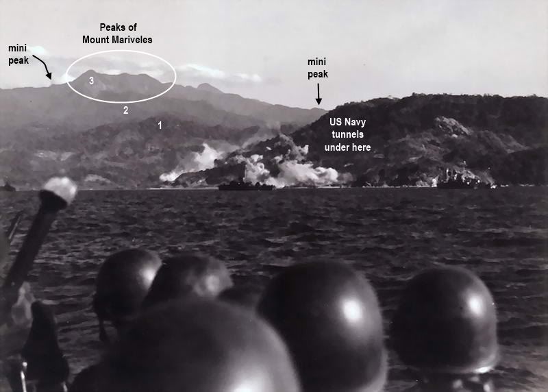 Your Photo #6. I took the next photo from Cochinos Point looking across Mariveles Bay. The landing craft was quite a bit to the right so the hill where the tunnels are located and Mount Mariveles would look much closer together than I can see from here. Many points do match though. 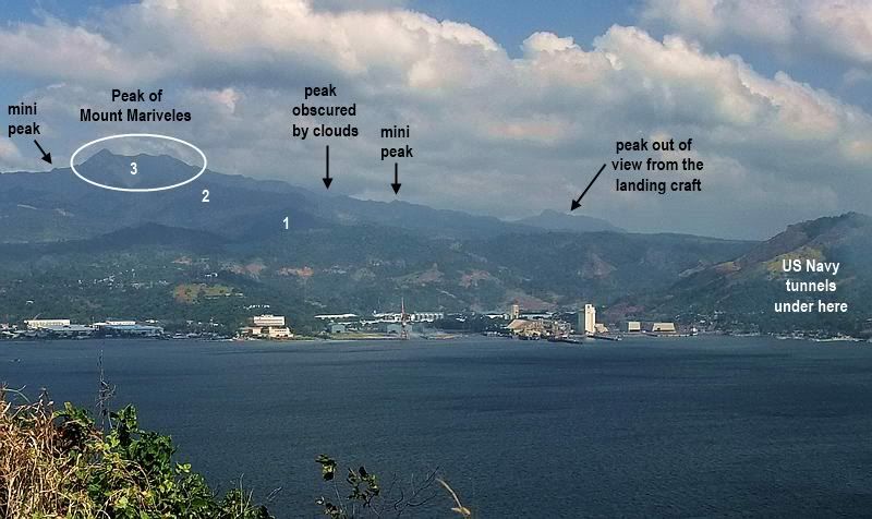 The view from Cochinos Point looking across Mariveles Bay. Photos #7 and #8 are basically the same shot probably taken seconds apart. In your photo #7 below, sloping up to the right is Mount Mariveles. Note the angle of the slope. There is also a raised area between the beach and the horizon. See the ‘mini double peaks’ in Mount Mariveles straight ahead and the three little cuts up the mountain from that? Clouds accumulate only near the peak of the mountain. 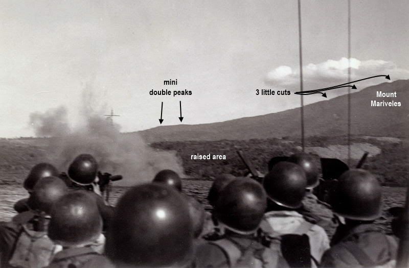 Your Photo #7. Here is a recent photo from further back but with a similar view. Note the same points mentioned above. Even the 66 year old clouds are still there. Ok, forget that point.  Actually it is rare that the top of Mount Mariveles does not have clouds around it. 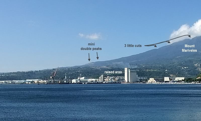 Looking towards Mariveles with part of Mount Mariveles in the background. Regarding photos #9 and #10, at Corregidor the landing craft dropped their doors on the beach. In these photos we see soldiers wading ashore. Which scenario occurred in Mariveles? Have a look at the next photo for the answer. 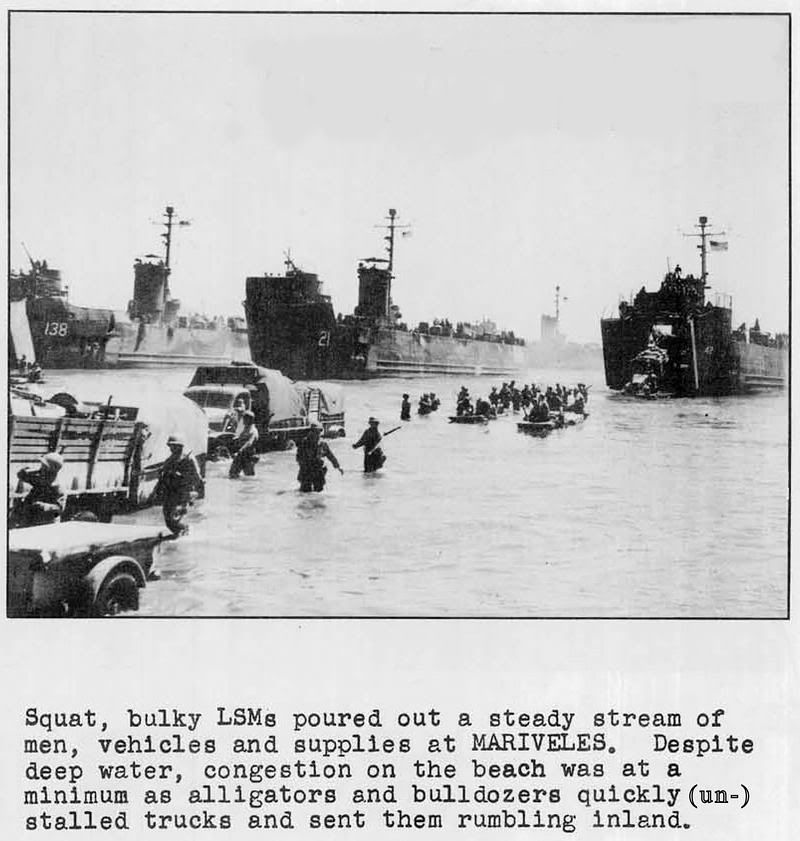 (photo source unknown) Only Photo #1 is Corregidor and that is the view you would have of the island as you approach Mariveles. The glare on the water tells me it is an early morning shot looking east (from the mouth of Manila Bay towards Corregidor) so perhaps this was taken from one of the ships before the Mariveles landing took place.  Your Photo #1. Here is a crop of a photo taken from Cochinos Point which is located on one side of Mariveles Bay. Since I am inside Manila Bay now, part of Corregidor’s tail is also in view. 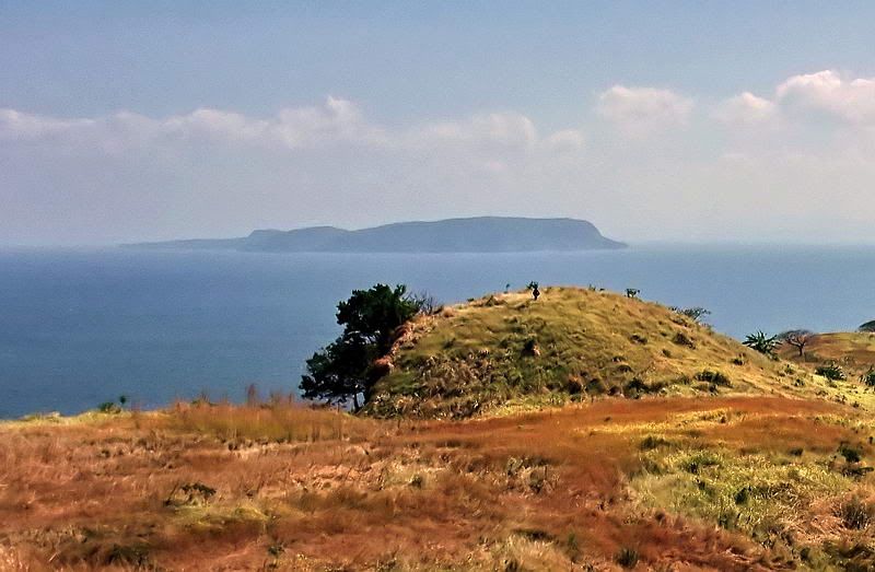 Corregidor as seen from Cochinos Point. I would say chances are quite good that your photos were taken 15th Feb, 1945 and show the 151st RCT (including the 34th Infantry that day) approaching and landing on Mariveles. I hope this helps answer your questions. |
|


 Actually it is rare that the top of Mount Mariveles does not have clouds around it.