|
|
Post by Karl Welteke on Jun 13, 2015 2:47:49 GMT 8
GUERRILLAS OF THE PHILIPPINES! This new thread is dedicated to the GUERRILLAS OF THE PHILIPPINES! I hope others also will use this Guerrillas in the Philippines in WWII page and report their stories and history of these Guerrillas. My first contribution after this introduction will be the COAST WATCHERS at the San Bernardino Strait who reported the Japanese Carrier Group steaming thru here in 1944 from west to east. Here is a teaser: After the fall of the Philippines in 1942 — and after leading the last horse cavalry charge in U.S. history — Lieutenant Ed Ramsey refused to surrender. Instead, he joined the Filipino resistance and rose to command more than 40,000 guerrillas. The Japanese put the elusive American leader at first place on their death list. Rejecting the opportunity to escape, Ramsey withstood unimaginable fear, pain, and loss for three long years. Lieutenant Ramsey's War chronicles a remarkable true story of courage and perseverance. This is the official website of Edwin Price Ramsey: www.edwinpriceramsey.com/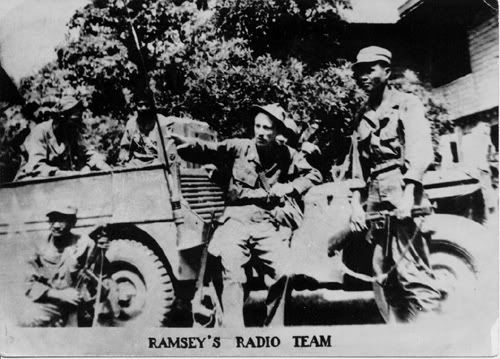 X544. Taken from Ramsey's site. Ramsey with his guerillas somewhere in the outskirts of Manila, after Gen. MacArthur’s landing on Luzon |
|
|
|
Post by okla on Jun 13, 2015 4:32:35 GMT 8
Hey Karl....I think I may have posted this tidbit regarding an Officer (Warrant) that I served with back in 1953-54, but will post it again since I may have, originally, put it up on Vic Varano's Philippine Scout Site. Anyhow, my Squadron Supply Officer, Chief Warrant Officer Lono was an ex Philippine Scout who "ditched" the Death March, headed into the Jungle with a few other comrades and served out the War as a Guerilla until they came out of the bush soon after the landings at Lingayen. I can't even attempt to spell his "real" last name. He had "Anglicized" it down to the much simpler "Lono" for conversational purposes due to it's tongue twisting pronounciation. He was a great guy and all we enlisted "swine" liked and respected him. I had always hoped that he would have been the Officer of the Day one night when I was pulling a shift as NCO Charge of Quarters so as to pick his brain regarding his guerilla activities, but, alas, that event never came to pass. I still rue it to this day. I missed a real opportunity to pick up some great "nitty gritty" concerning one of my favorite subjects. Man o man, could I have fed my Bataan/Corregidor addiction. Mister Lono had remained with the US Army until the Scouts were deactivated in 1947. He, at that point, transferred into the Army Air Corps and then transitioned into the USAF in 1948 when it was made independent from the Army. Mister Lono is now revealed to this Forum just in case my original posting was on Vee Vee's site. Cheers.
|
|
|
|
Post by Karl Welteke on Jun 13, 2015 12:26:47 GMT 8
15TH JUNE 1944 COMING THRU SAN BERNARDINO STRAIT, A JAPANESE IMPERIAL NAVY CARRIER BATTLE GROUP. 2 Small Patrol Boats 2 Destroyers 2 Cruisers Atago class 2 Cruisers Mogami class 2 Cruisers Tone class 2 Destroyers 2 Battleships Kongo class 3 Aircraft Carriers 1 Light Cruiser Agano class 2 Cruisers Nachi class 2 Destroyers 3 Aircraft Carriers 2 Destroyers 3 Aircraft Carriers 1 Destroyer 1 Battleship Nagato class 1 Cruiser Tone class. The above was reported by the Coast Watcher Station MAG commended by Lt. Gerald Chapman. It was located in Santa Magdalena Municipality, in the province of Sorsogon next to the San Bernardino Strait 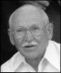 X545. Gerald Chapman, the picture is cropped form the 1994 AGOM reunion. This is his story from AGOM (American Guerrillas of Mindanao) lanbob.com/lanbob/FP-AGOM/H-AGOM-JChapman.htmThis above webpage is not long! The Americans were alerted and that resulted in the: The Battle of the Philippine Sea (June 19–20, 1944) was a decisive naval battle of World War II which eliminated the Imperial Japanese Navy's ability to conduct large-scale carrier actions. It took place during the United States' amphibious invasion of the Mariana Islands during the Pacific War. This battle is popular known as the: “The Great Turkey Shoot” The Losses of this battle: American: 1 battleship damaged, 123 aircraft destroyed. Japanese: 3 fleet carriers sunk, 2 oilers sunk, 550–645 aircraft destroyed, 6 other ships damaged 2,987 dead (estimate). The last two paragraphs came from the Wikipedia page: en.wikipedia.org/wiki/Battle_of_the_Philippine_Sea |
|
|
|
Post by Karl Welteke on Jun 16, 2015 12:17:34 GMT 8
COAST WATCHER STATION MAG MOVES TO SORSOGON FROM SAMAR Coast Watcher Station MAG commanded by 2nd Lt. Gerald S. Chapman was set up on the Northwestern tip of Samar in late September, 1943, with the primary mission to report on shipping through the San Bernardino Straits. Additional tasks were to report on aircraft and any significant ground activity of the Japanese forces. In the spring of 1944, there was a significant increase in enemy activity around the small peninsula where the station was located and intelligence indicated that the Japanese were aware that the station was in the area and were trying to pinpoint the location. Because of this threat to our security, a decision was made to move the station across the Straits to Sorsogon. The move was made of the night of 4 April, 1944. In many ways, the move enhanced our mission by getting access to intelligence information on the disposition of Japanese forces in the Southern Luzon area, gaining a better vantage point for observing the Straits and improving our source of supplies. The above paragraph has been copied from the below AGOM web page: lanbob.com/lanbob/FP-AGOM/H-AGOM-JChapman.htmAs I have said before there are not many areas in the Philippines that have not been touched by WWII. Every year my family visits the Municipality of Matnog, to my wife’s village. The Municipality Matnog and the neighbor Municipality of Santa Magdalena where the Coast Watcher Station MAG moved in 1944 are forming the north shore of the San Bernardino Strait. I had the privilege of walking on the shore lines of both of these Municipalities and it feels good to walk on the ground of that WWII struggle, in the footsteps of history. I like to share a few photos and maps of the area of Santa Magdalena to show that geography is important to plan effective actions against one’s enemy. The higher resolution copies are in this album (17 images numbered C1 to C17): app.photobucket.com/u/PI-Sailor/a/31978bd1-7ac0-45ae-a849-60737ead879c Note from Karl: as of 24th March 2022 this link is active again In this presentation are the same images but they are much smaller here: 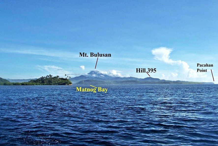 X569 if you were coming from Port Allen in Samar on a nice day you would have this great view of the Matnog and Santa Magdalena areas. 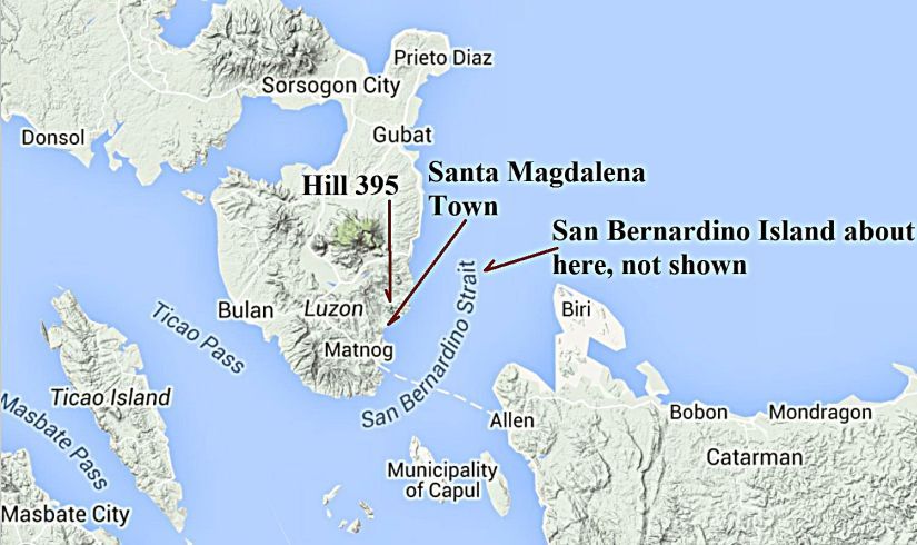 X570 the big picture of the San Bernardino Strait area. 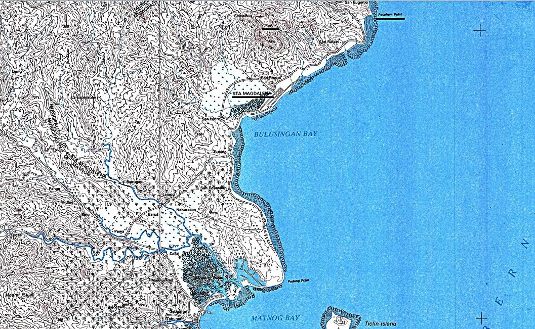 X571 a section of an 1:50000 map about the Matnog and Santa Magdalena areas. I underlined Santa Magdalena and Pacahan Point 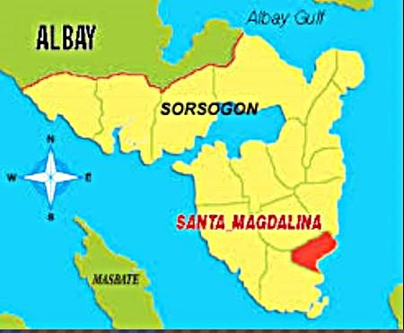 X572 this graph shows the location of the Santa Magdalena Municipality. 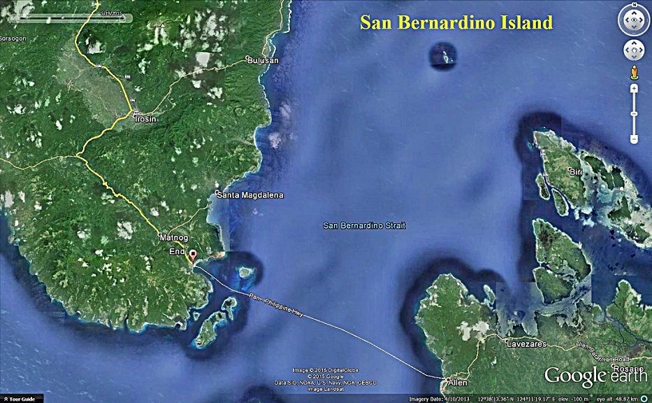 X573 San Bernardino Island is small and none of the other graphs show it, so here is a Google image that does show it. 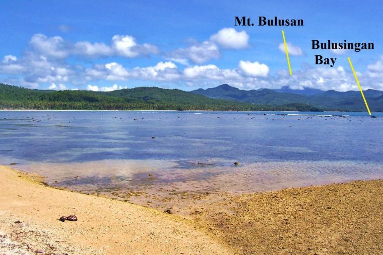 X574 I have walked from Matnog to Santa Magdalena a couple of times and back. Coming from Matnog and going around the last point you get this great view of the Bulusingan Bay. 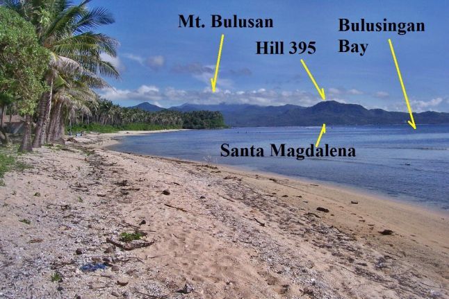 X575 this is a great view of the Bulusingan Bay, Santa Magdalena proper is located on this side of Hill 395 on the shore of this bay. 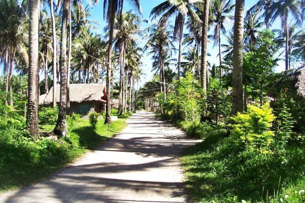 X576 much of the shoreline between Matnog and Santa Magadalena is low grounds and would not be a good hiding place for the Guerillas. Now there is this road along the shore line. 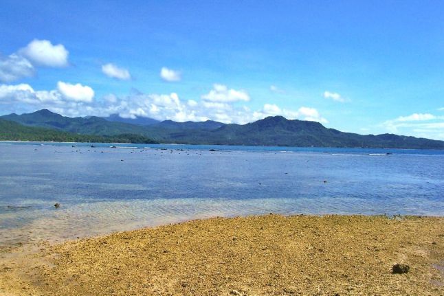 X577 The hill, a little right of center, is Hill 395 (check the map)and would be the ideal place for the Coast Watchers to keep an eye of the traffic going thru the San Bernardino Strait. 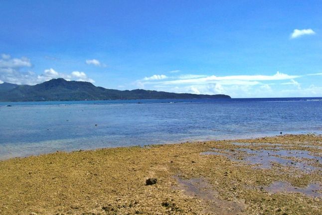 X578 the hill at left is Hill 395 (check the map) and the rugged hills behind it or north of it offer a good route to retreat from the Japanese enemy, should he come looking. 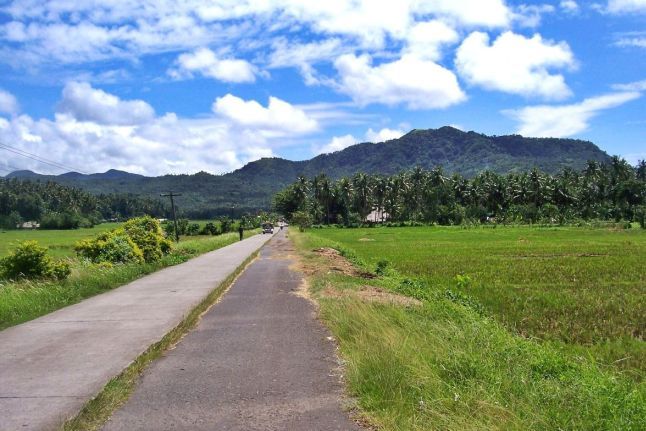 X579 at this point the road to Santa Magdalena goes inland a bit because at right is a large wetland area with nipa and mangrove plants. Hill 395 is at right. 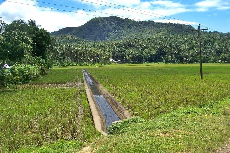 X580 Hill 395 is in front of us; basically Santa Magdalena is at the mouth of a valley that comes from the left. That hill would make a great watch point covering San Bernardino Strait. 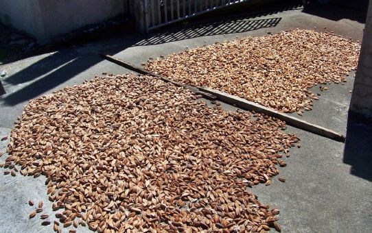 X581 sometime I also take other pictures, these are pili nuts being dried along the road. Sorsogon province is part of the Bicol Region and the pili nut is a specialty of the region. 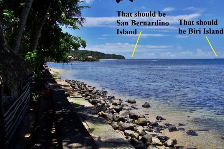 X582 I am standing at the shore line in Santa Magdalena and have this great view of the east end of the San Bernardino Strait. 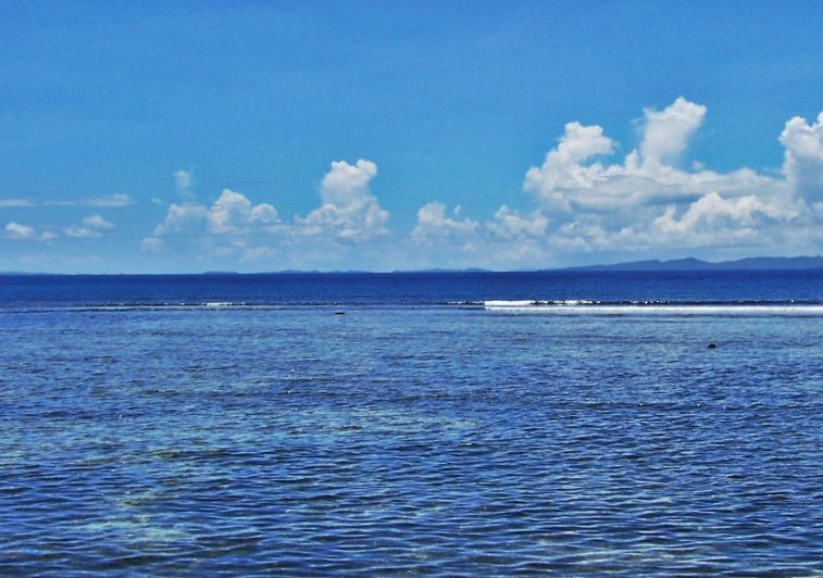 X583 this is a look across the eastern end of San Bernardino Strait, in back are the northern islands of Samar, the most left one should be Biri Island. 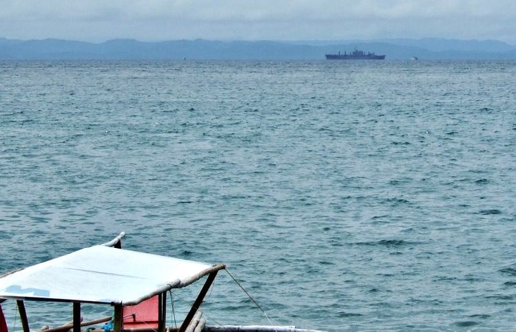 X584 on the 18th of May 2009 I caught this US Naval Ship (USNS) coming thru San Bernardino Strait, from west to east, maybe going to Guam. Ahead (small) and astern of the USNS vessel you see the ferries crossing the strait. 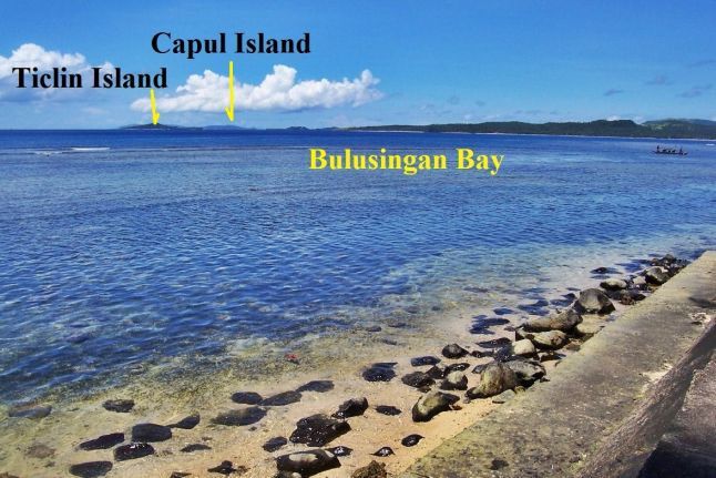 X585 this is a look back in the direction of Matnog and Capul Island from Santa Magdalena town. To me it is a great view and I feel fortunate to walk in the footsteps of history. |
|
|
|
Post by beirutvet on Jun 17, 2015 6:37:02 GMT 8
Karl
Excellent history lesson there, please keep up the good work, I enjoy all of your posts.
Isn't the San Bernardino Straits the path that the upper portion of the pincer movement took that was meant to attack and stop the landings on Leyte? If so I believe that is the portion of the Japanese task force that had the Yamato in it. That of course is a huge story that has been told many times as the largest naval engagement of all time, the Battle of Leyte Gulf. Taffy 3 was defending the beach head, and 11 escort carriers with nothing but destroyers and destroyer escorts. This particular battle was, I think, well chronicled in the book 'The Last Of The Tin Can Sailors'. I highly recommend it. I am sorry that I do not have the book handy as I gave it to my brother to read or I would include the authors name.
Do you know if the coast watchers that you have cited above were able to spot the convoy as it navigated the straits? I would guess that when they went through the straits it was at night and not sure if they would have been visible. And if they did spot them, where they able to get word to anyone in time?
Regards
|
|
|
|
Post by okla on Jun 17, 2015 7:07:07 GMT 8
Hey Beirut....Here's a little tidbit that I thought you might find interesting. I used to work with this older guy who was in the "black gang" of the old USS Pennsylvania from when she was finished with her repairs suffered at Pearl Harbor until her return to the West Coast after VJ-Day. He said that during the night action at Leyte, when the American Battleships lined up and slaughtered the Japanese formation attempting to force the Suragaio (sp  ) Strait, the Bridge kept the guys down below up to date on what was happening. He said it was akin to listening to a play by play of a ball game. He said it was almost unreal. The "Black Gang" kept the boilers going and the gunners kept the big stuff firing and the "pregnant dog box" kept all concerned on the momentous goings on top side. Cheers. |
|
|
|
Post by beirutvet on Jun 17, 2015 9:58:37 GMT 8
Okla
Hey that is way cool and you are right, I do find that interesting. Pregnant Dog Box? That is definitely one I had never heard before. You never cease to amaze. Also amazing is your ability to run across all these guys who have lived it! Someday I hope to be going through Oklahoma and maybe we can get together over a meal and some beers (San Migs, if we can find them for a fitting tribute) and you can regale me with all your travels.
The Surigao contingent would have been the southern force of the pincer that got its ass handed to them in a hand basket. (the japs, that is) That would have been something to be in on that, even if you were on the black gang. Nothing like action to pull a WHOLE crew together. I can only imagine what a surface battle like that would have been like.
Regards
|
|
|
|
Post by okla on Jun 17, 2015 19:24:46 GMT 8
Hey Beirut....When you get to be my age (83 next month) you will have met a lot of people and heard a lot of stories and anecdotes. I especially appreciated the yarns I have picked up from the older men that I served with from 1951 til 1955 while in the USAF, especially the several that were Bataan/Corregidor Campaign survivors. Some stories I had forgotten until someone making a post on this Forum rekindles my memory. The sailor from the "Pennsy" is a prime example. I haven't thought of him in several years. He passed away quite sometime ago. Postscript....My description of the PA System utilized to keep the "Black Gang" up to date was "sanitized" to some degree but you got my drift, I am sure. Also, meeting up if you ever pass thru my State would be a treat, although I wouldn't be hoisting a beverage, I quit the hard stuff way back in the 1980s due to health reasons. I don't even take the Wine at Communion, only the wafer. I figured if you are going to "give it up" then go the whole nine yards. Cheers.
|
|
|
|
Post by Karl Welteke on Jun 24, 2015 13:13:36 GMT 8
COASTWATCHER STATION SET UP IN NW SAMAR, AT BALICUATRO POINT Coast Watcher Station MAG commanded by 2nd Lt. Gerald S. Chapman was set up on the Northwestern tip of Samar in late September, 1943, with the primary mission to report on shipping through the San Bernardino Straits. The American Guerrillas On Mindanao Association (AGOM) have this web page on 2nd Lt. Gerald S. Chapman; it is not too long: lanbob.com/lanbob/FP-AGOM/H-AGOM-JChapman.htmWhere is Balicuatro Point in NW Samar? 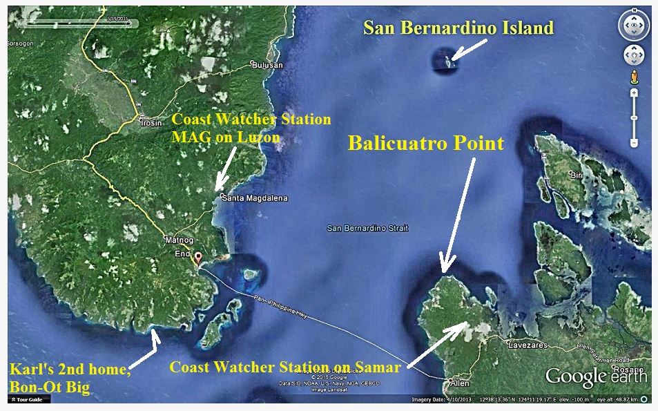 X632 the Google Earth image that shows Balicuatro Point, the Balicuatro Peninsular, its two main communities, Port Allen and Lavezares Town 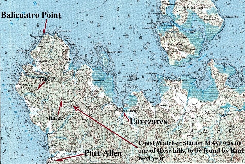 X633 is a section of an 1:50000 map of North Samar and shows Balicuatro Point, the Balicuatro Peninsular, its two main communities, Port Allen and Lavezares Town and Hills 217, 227 the highest elevations on the peninsula. Here is a personal angle A friend of ours, Louis Jurika, is the son of the well known guerrilla Tom Jurika. This year he gave a presentation at the General MacArthur Museum in Norfolk about the experience of his father and uncle as guerrillas in the Philippines during WWII. He made the transcription of his presentation available to this forum and it is posted here at this URL: corregidor.proboards.com/thread/1831/crossroads-history-crosshairs-enemyIt is titled: A Guerrilla Odyssey - Tom Jurika & Chick Parsons “At the Crossroads of History and in the Crosshairs of the Enemy.” Here is the main paragraph germane to the NW Samar Coast Watcher Station. It is located about half way down in that URL and is followed by a few more paragraphs about setting up this Coast Watcher Station MAG on NW Samar: In 1943 Tom Jurika was busy setting up coast watcher stations and many a rendezvous with incoming submarines, devising an efficient and easily-recognized signal system from guerrillas on shore that submarine skippers appreciated. After Tom had brought Cap and Charlotte Martin out of hiding and put them aboard the submarine Narwhal in November, 1943, at Butuan, Mindanao, he took on the mission of leading a guerrilla team from Mindanao all the way to the tip of northern Samar and strategic San Bernardino Straits. Here he would install a coast watcher named Gerald Chapman to monitor any Japanese merchant shipping or naval movements in this important passage through the Philippines between the Pacific Ocean and the South China Sea. It was Chapman who eventually reported the Japanese navy moving through the straits on their way to annihilation in what became known as “the Marianas Turkey Shoot”. On the previous map you can see that I call a small place nearby, home, some of the time. And indeed I have been in the neighborhood of both locations belonging to Coast Watcher Station MAG. I visited or passed thru Port Allen twice but it was before I know that this area played a role in WWII. The next time I go here, should be next year I will search for the footsteps of this WWII story. I like to share a few photos and maps of the area of the Balicuatro Point Peninsular. The higher resolution copies are in this album (5 images numbered D1 to D5): app.photobucket.com/u/PI-Sailor/a/31978bd1-7ac0-45ae-a849-60737ead879c Note from Karl: This link is active again as 24th March 2022! 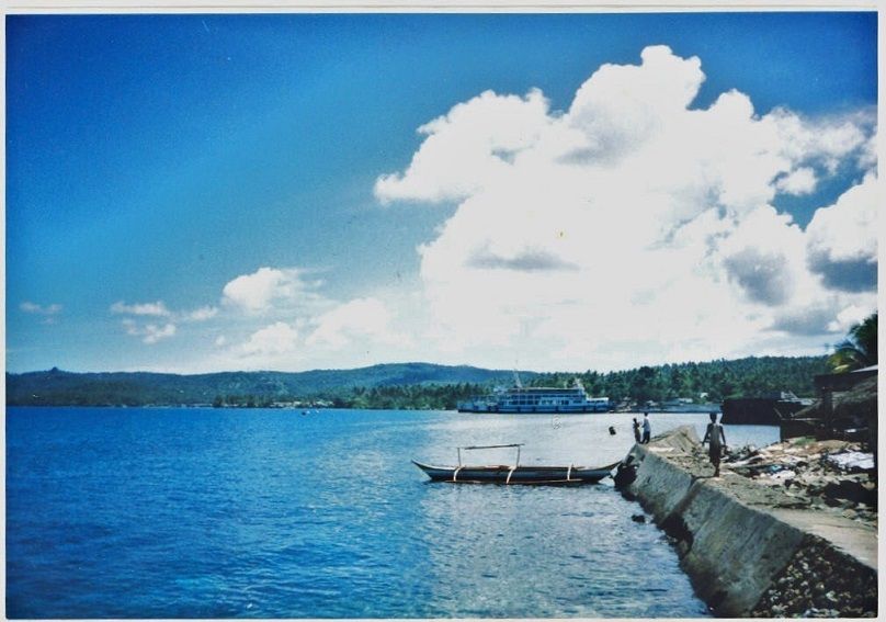 X634 this is a scan from a 2001 image of Port Alan. The view is in the NE direction across the peninsular. As you can tell I did walk around a little in Port Allen. 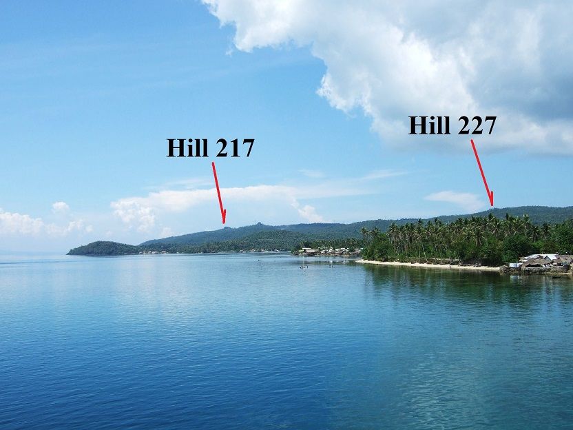 X635 a view of the Balicuatro Peninsular from Port Alan in Sep. 2007. According the map the two highest points on the peninsular are 217 and 227 meter high hills, but from this angle I am not sure I picked the right ones. 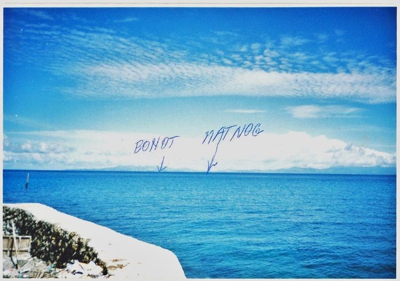 X636 a 2001 view across the San Bernardino Strait from Port Allen towards Matnog. I had come across with the ferry, just to look around. Next time I will explore. Note 1: Lou Jurika was born in the Philippines and grew up here and has learned much of the history of the Philippines. His father, Tom Jurika, was a Guerrilla Hero, and so was his Grandmother. His Grandmother was executed by the Imperial Japanese occupiers in Manila. At one time he moved to Norfolk and did one whole year research in the Gen. MacArthur Museum. All this information that he gathered from his father and family, from reading and the research work cumulated in this work, titled: A Philippine Odyssey by Louis Jurika It is available with this URL, about 6 PDF pages: corregidor.org/crypto/intel_01/A%20Philippine%20Odyssey%20-%20Louis%20Jurika.pdfNote 2: The Gen MacArthur Museum interviewed 2nd Lt. Gerald S. Chapman, the Coast Watcher in this thread. The 2nd half of the interview was carried out by Louis Jurika, I have a copy of that unedited transcript of that interview and will add some parts of the interview in this thread in the future. |
|
|
|
Post by okla on Jul 12, 2015 4:18:15 GMT 8
Hey Guys....I have a question for our Forum Gurus that has been floating around my mind for quite sometime regarding the resistance/underground/etc activity during those early months of 1942. Does anybody have any knowledge of personnel moving to and from Manila to Corregidor prior to the surrender (especially the surrender of Bataan) I have read of a Captain Ivey and his group going into Batangas to repair the water line ( ) that served For Frank, but I am referring to individuals sneaking into Manila from The Rock and vice versa. I don't know what this kind of activity could have accomplished at that late date in the PI Saga, other than, maybe, picking up some info on goings on at Homma's HQ. It might have been to our advantage to know if the good General was suffering from VD or Hemorrhoids, etc.. I am serious, though, in learning if this kind of activity did take place. Japanese patrols in Manila Bay would,I think, have been limited since it would have depended upon using captured Filipino water craft. Not having any knowledge of how much of this type small craft and larger vessels was available, it is difficult for me to conjure up the scope of these clandestine operations, if they, indeed, took place. Just wonderin'. One's mind tends to wander far afield at my age. Cheers. |
|


 ) Strait, the Bridge kept the guys down below up to date on what was happening. He said it was akin to listening to a play by play of a ball game. He said it was almost unreal. The "Black Gang" kept the boilers going and the gunners kept the big stuff firing and the "pregnant dog box" kept all concerned on the momentous goings on top side. Cheers.


