|
|
Post by makoy on Apr 14, 2016 9:45:40 GMT 8
|
|
|
|
Post by chadhill on Apr 19, 2016 9:04:42 GMT 8
Thanks makoy, these bring back old memories from the 1980s. What's the date stamped into the embedded round plate? Is it 1944?
|
|
|
|
Post by makoy on Apr 19, 2016 23:25:27 GMT 8
Thanks makoy, these bring back old memories from the 1980s. What's the date stamped into the embedded round plate? Is it 1944? i cannot tell from the picture. but ill check in person once i get back to the backroads. I wish I had an old map road of the area |
|
|
|
Post by Karl Welteke on May 7, 2016 9:01:13 GMT 8
NAVAL MAGAZINE WALK 2008 Hello makoy your thread here motivated me to make this entry This walk is from the former Cubi Point Naval Air Station to the Morong Gate in the Subic Bay Freeport Zone (the former Subic Bay Naval Base). It was on the 22nd Oct. 1908. This walk was basically in the former Naval Magazine area. I entered several side valley, roads and trails. I established this album with 84 images and this is the URL: s74.photobucket.com/user/PI-Sailor/library/SBFZ%20Ex%20Naval%20Base%20Subic%20Bay/SBFZ%202008/Cubi-Morong%20Gate%202008-10-22?sort=9&page=1Here are 5 sample images 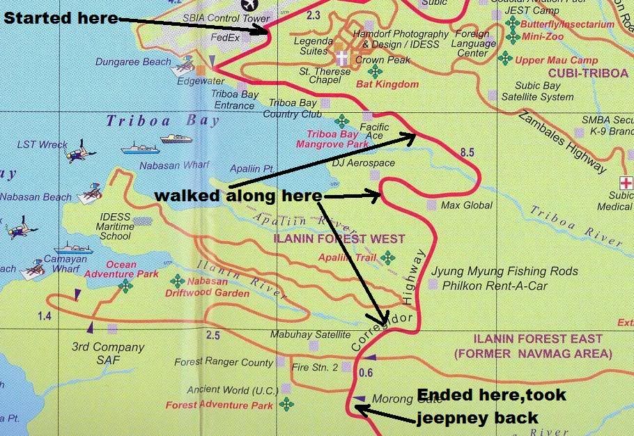 W756 this map from EZ Maps shows the starting and ending point of my hike today, the 22nd Oct. 2008 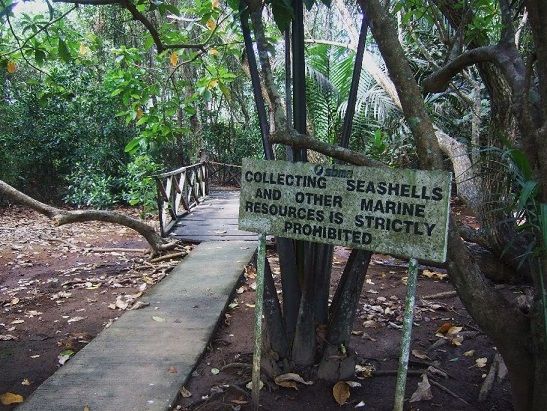 W757 this sign is located at the entrance to the mangrove park next to the former Naval Magazine Gate. 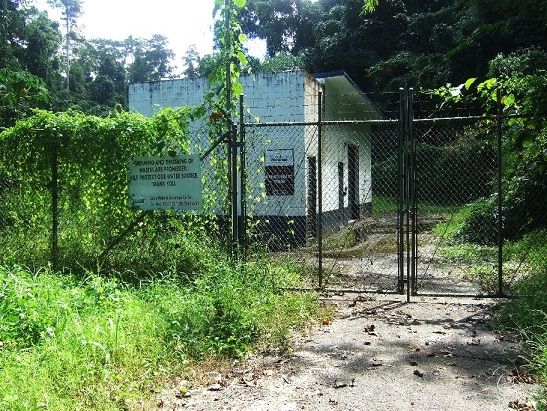 W758 the Triboa River Water Pump Station.  W759 this is Marcello Solomon (not sure about the 1st name), he lives here in one of the magazine maintenance huts and works as a guide for the SBFZ Tourist Department and was a guide to the USMC patrols in the Magazine area. He also told me how much better the pay was under the US management.  W760 this is the Morong Gate Park, inside the gate, this image shows you here how the rainforest looks like with the underbrush cleared. The above album and the pictures are also presented in a large thread in this forum about Subic Bay; this is the URL for page 5.The picture below is from the 9th Nov. 2015 entry called: GREEN BEACH THE MARINE TRAINING AREA IN SUBIC BAY: corregidor.proboards.com/thread/1541/subic-bay-sbfz-naval-base?page=5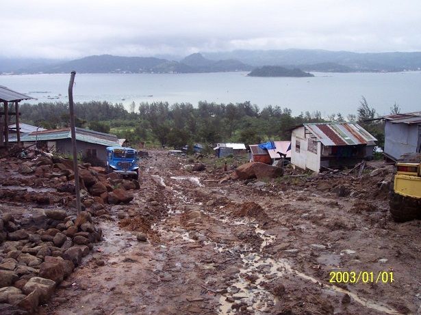 W300 (A8) this is a picture of Agusuhin Village 2006-Aug-4. This is a look down slope; most people should be able to recognize Pequena Island (most of us referred to it As Snake Island). The road and houses have improved by now in 2015. The real date of this picture is 2006-Aug.-04, the imprint is wrong. A Marine friend asked what happened to the people on Green Beach, Subic Bay, the Marine training area and I uploaded a few pictures into this album: s74.photobucket.com/user/PI-Sailor/library/Philippines/Korean%20Shipyard-Redondo%20Mt/Korean%20Shipyard-Redondo%20Mt%20area%20No%201/Agusuhin%20Village%202006-Aug-4?sort=9&page=1 In 2006-Aug. 4th friends and I visited the Agusuhin Resettlement on the slopes of Redondo Mountain and these pictures are from this date. The date imprint of 2003 is wrong, because of a camera problem. This village was located in the area our Marines called: Green Beach. The construction of the Korean Shipyard Hanjin had started the year before in the area of the Green Beach and the people were resettled here. Our impression was that the authorities had done a bad job and the pictures show it. These pictures were shot on Aug. 4th 2006 and the Agusuhin Resettlement was looking pretty bad then. This album was established on the 7th of Nov. 2015 and the situation has vastly improved since then. |
|
|
|
Post by makoy on May 9, 2016 22:22:12 GMT 8
hi Karl.
thank you for the additional photos. I am quite familiar to most if not all of the places you took pictures from. I've been to those places mostly on my mountainbike. I have mapped a few forest patrol tracks in the jungle and the grasslands on the hermosa boundary where they are putting up the solar farm
I am very excited on the patrol and "abandoned" watertank service roads that Ive seen. Ill try to look for photos and post them asap
cheers
makoy
PS.
I am pretty sure I have seen you around on your hikes. I live in Binictican and just around the villaga are networks of unused road and paths
|
|
|
|
Post by makoy on May 9, 2016 22:39:14 GMT 8
 in one of the water spill ways near Binictican, feeding a catch basin that feeds the water treatment plant near the golf course  one of those locked gates inside the jungle  on a ridge overlooking subic bay  in the foreground, subic bay and mt sta rita |
|
|
|
Post by Karl Welteke on May 10, 2016 20:34:10 GMT 8
Hello makoy
I really like the picture with the description: “on a ridge overlooking subic bay”. That is a great shot!
|
|


