|
|
Post by Karl Welteke on Oct 18, 2016 20:30:23 GMT 8
Battery Crofton This entry shows construction of Battery Crofton in Fort Frank on Carabao Island in Manila Bay. Fort Frank was part of the Manila and Subic Bay Harbor Defense Command. These 10 images were given to me by Karl Schmidt from the Coastal Defense Study Group (CDSG.org) who got the images from National Archives and Records Administration (NARA). Thank you Karl and all members of the CDSG. The pictures were uploaded at a high resolution into this Flickr album. www.flickr.com/photos/44567569@N00/albums/72157673964028162More pictures of the Fort Frank construction will follow. Here, in the forum, are the same 10 pictures but are much smaller. 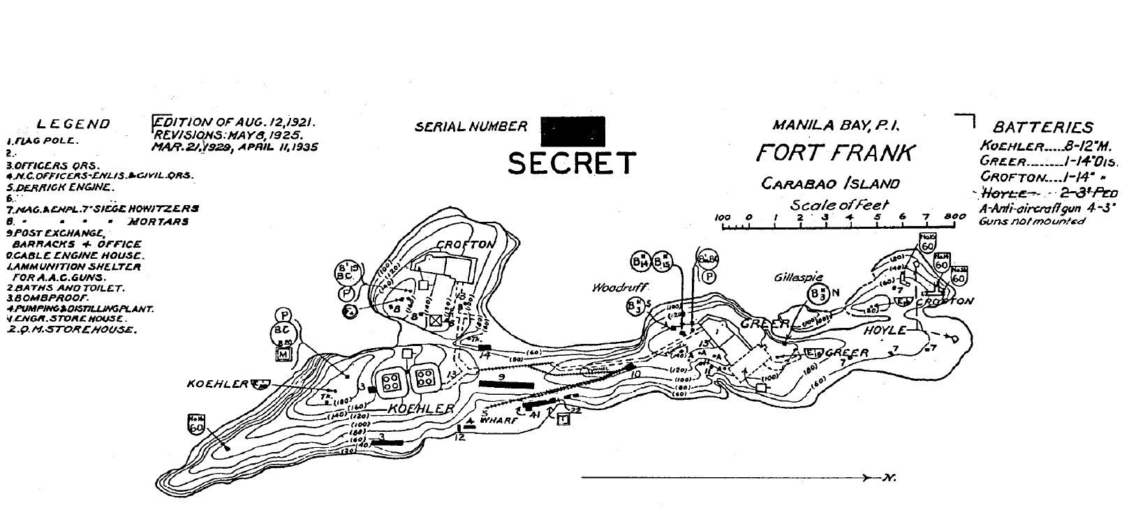 00 Fort Frank on Carabao Island 1935 map which I got from the Coastal Defense Study Group (CDSG.org). This map will be the 1st image in this album for your orientation. This map is in the original size, a larger size. 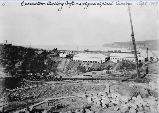 V276, (zPcon-113). This view seems to be from the excavation area for the future Battery Crofton for Ft. Frank on Carabao Island, towards east and we see land points of Cavite Province in back. Photo, courtesy of Karl Schmidt, CDSG.org who got it from NARA. 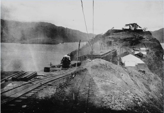 V277. (zPcon-116). This view is towards south on Carabao Island, in Manila Bay, during the construction of Fort Frank. Photo, courtesy of Karl Schmidt, CDSG.org who got it from NARA. 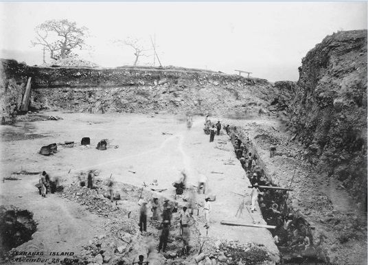 V278. (zPcon-122). This picture is dated 28 Dec. 1909 and it seems the excavation for the future Battery Crofton, Fort Frank on Carabao Island is almost complete. Photo, courtesy of Karl Schmidt, CDSG.org who got it from NARA. 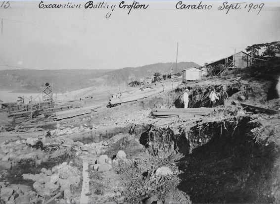 V279. (zPcon-124). The description of this image says: Excavation of Battery Crofton in Sep. 1909. This is the future Fort Frank on Carabao Island in Manila Bay. Photo, courtesy of Karl Schmidt, CDSG.org who got it from NARA. 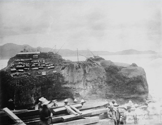 V280. (zPcon-129). This picture is dated 28 Dec. 1909 and the description says; looking south at the excavation of Battery Crofton. Photo, courtesy of Karl Schmidt, CDSG.org who got it from NARA. 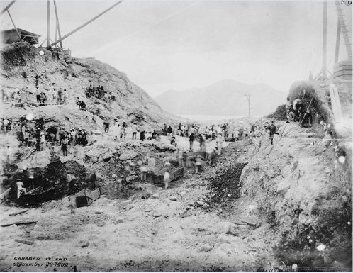 V281. (zPcon-130). This picture is dated 28 Nov. 1909 and the description says; excavation of Battery Crofton. It looks like they use a lifting boom to take out the boxes with dirt. Photo, courtesy of Karl Schmidt, CDSG.org who got it from NARA. 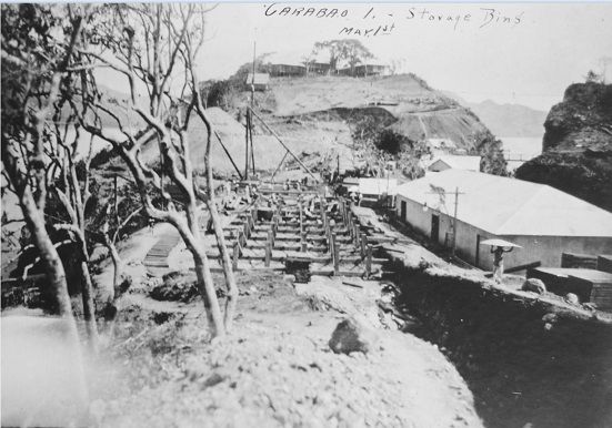 C282. (zPcon-137). We are looking south on Carabao Island, at the future Fort Frank in Manila Bay. The description says, storage bins and 1st of May, I believe we can assume it is 1909. I see a light bridge leading to the future Battery Crofton. Photo, courtesy of Karl Schmidt, CDSG.org who got it from NARA. 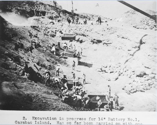 V283. (zPcon-140). Before Battery Crofton got its name the battery site was referred to as Battery No. 1. We clearly can see that a lifting boom was used to take out the boxes with dirt. Photo, courtesy of Karl Schmidt, CDSG.org who got it from NARA. 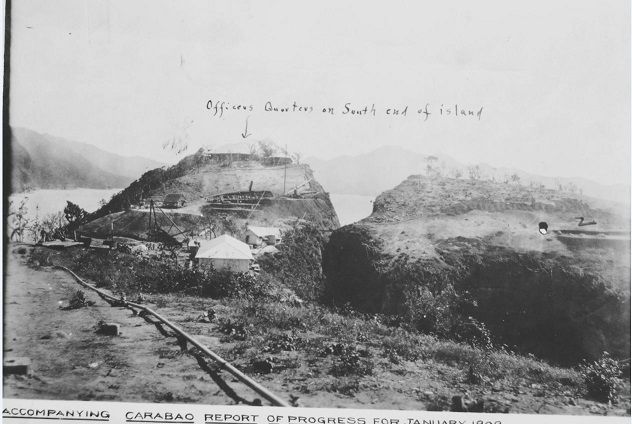 V284a. (zPcon-150). The future Battery Crofton is at right and we are looking south again on Carabao Island in Manila Bay. This construction will be the future Fort Frank. Photo, courtesy of Karl Schmidt, CDSG.org who got it from NARA. |
|
|
|
Post by fortman on Oct 19, 2016 0:04:44 GMT 8
Many thanks Karl. Great stuff.
Fortman
|
|
|
|
Post by Karl Welteke on Oct 21, 2016 20:40:11 GMT 8
Battery Koehler Fort Frank on Carabao Island under construction This entry shows construction of Battery Koehler in Fort Frank on Carabao Island in Manila Bay. Fort Frank was part of the Manila and Subic Bay Harbor Defense Command. These 10 images were given to me by Karl Schmidt from the Coastal Defense Study Group (CDSG.org) who got the images from National Archives and Records Administration (NARA). Thank you Karl and all members of the CDSG. The 8 pictures were uploaded at a high resolution into this Flickr album. I put the letter y in front of the original number of the image so the pictures will end up more to the end of the album: www.flickr.com/photos/44567569@N00/albums/72157673964028162More pictures of the Fort Frank construction will follow. Here, in the forum, are the same 8 pictures but are much smaller. 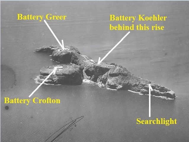 V285 (01) Aerial view of Fort Frank on Carabao Island 1923 which I got from the Coastal Defense Study Group (CDSG.org). This picture will be the 2nd image in this album for your orientation. 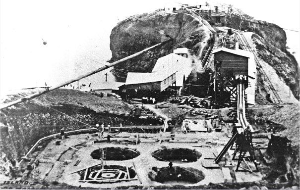 V286. (yPcon-065 77F). Carabao Island runs pretty much on a north-south axis; in this picture we are looking north. Battery Koehler will be a Battery with (8) eight 12 inch mortars. The 8 mortars are placed in two pits with 4 mortars each; they are next to each other. This image shows the northern mortar pit with 4 guns. This picture was shot in the last three months of 1908. 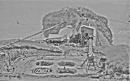 V287. (yPcon-114 77F). This is the same picture as the last one but has different lighting and some objects are clearer that the than on the last image. Carabao Island runs pretty much on a north-south axis; in this picture we are looking north. Battery Koehler will be a Battery with (8) eight 12 inch mortars. The 8 mortars are placed in two pits with 4 mortars each; they are next to each other. This image shows the northern mortar pit with 4 guns. This picture was shot in the last three months of 1908. 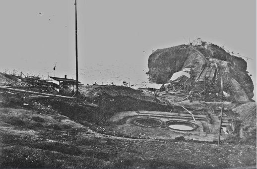 V288. (yPcon-132 77F). This picture shows only two of the Battery Koehler mortar well-holes. It must have been shot earlier that the last two Battery Koehler images. 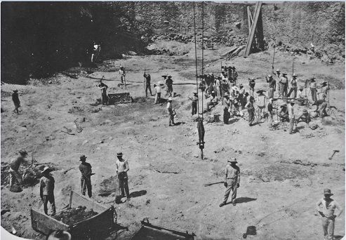 V289. (yPcon-133 77F). This picture prescription says 8th Jan or 1st Aug 2009; we must be looking south because the island rises in height south of Battery Koehler. Most of the excavation is done and I think the group of people at right seem to stand in a circle where most likely the most SW gun well will be dug. 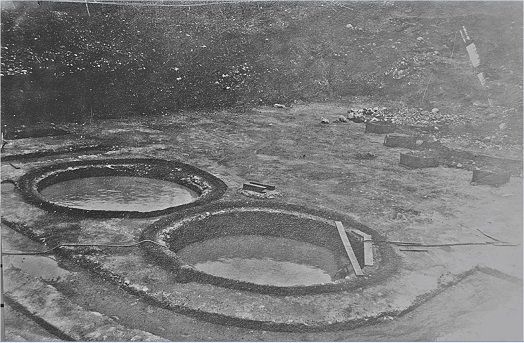 V290. (yPcon-141 77F). This picture prescription says 8th Jan or 1st Aug 2009; we must be looking south or better SE. These two mortar gun well-holes must be the two (2) furthest north of Battery Koehler under construction on Carabao Island. 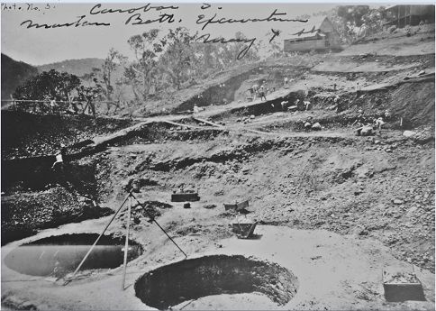 V291. (yPcon-142 77F). One thing I am sure of that this picture was shot 2009 and we are looking into the south-east direction in the excavation of Battery Koehler, future Ft. Frank on Carabao Island. 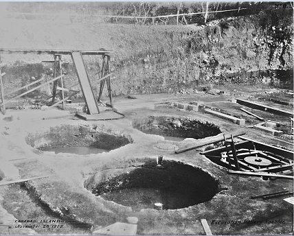 V292. (yPcon-145 77F). The description of the images says that it is dated 28th Nov. 1909. I would say we are looking east by south-east (E by SE) over the excavation of Battery Koehler, future Ft. Frank on Carabao Island. It seems the four furthest north mortar well-holes have been dug. |
|
|
|
Post by Karl Welteke on Oct 22, 2016 12:55:53 GMT 8
Battery Greer Fort Frank on Carabao Island under construction This entry shows construction of Battery Greer in Fort Frank on Carabao Island in Manila Bay. Fort Frank was part of the Manila and Subic Bay Harbor Defense Command. These 7 images were given to me by Karl Schmidt from the Coastal Defense Study Group (CDSG.org) who got the images from National Archives and Records Administration (NARA). Thank you Karl and all members of the CDSG. The 7 pictures and 1 map were uploaded at a high resolution into this Flickr album. I put the letter x in front of the original number of the image so the pictures will end up more to the end of the album: www.flickr.com/photos/44567569@N00/albums/72157673964028162More pictures of the Fort Frank construction will follow. Here, in the forum, are the same 7 pictures and 1 map but are much smaller. 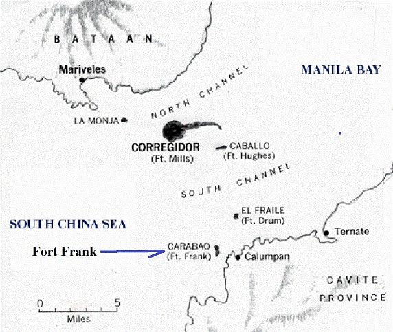 V293. (02) Manila Bay map with the island forts. 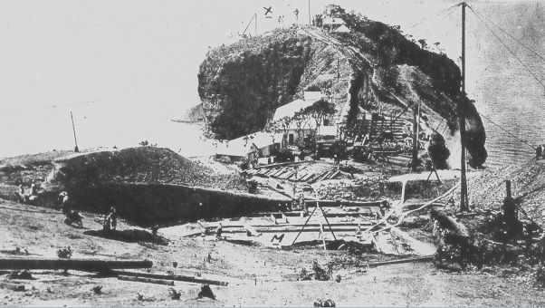 V294. (xPcon-062 SB). This view is looking north towards Battery Greer from sitting south and above the excavation area of Battery Koehler. This is on Carabao Island in Manila Bay and the picture description dated this picture May 1st 1909. This image is from Karl Schmidt (CDSG.org) who got the images from (NARA) 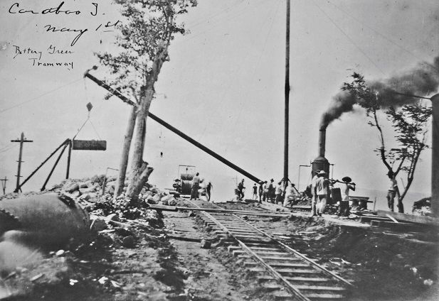 V295. (xPcon-117 77F-111-124-20) Ft Frank Greer tramway 3-09. This is a nice picture of the tramway to the construction site of Battery Greer, for the future Fort Frank on Carabao Island. It also has a nice shot of the boom in action swinging a load of dirt to its dumping or storing location. This image is from Karl Schmidt (CDSG.org) who got the images from (NARA). 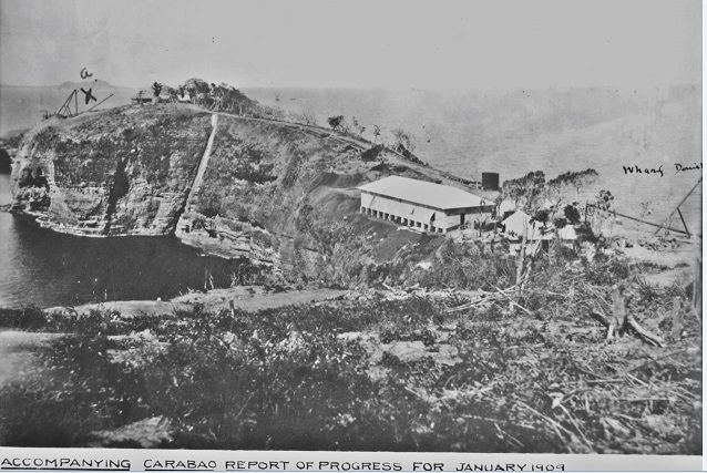 V296. (xPcon-118 77F-111-124-5 Ft Frank 14-in No. 1 4-02-09). This is a long distance shot of the Battery Greer site from the Battery Crofton site. Caballo Island also can be seen in the distance. This is on Carabao Island in Manila Bay, site of the future Fort Frank and the picture description is dated January 2009. This image is from Karl Schmidt (CDSG.org) who got the images from (NARA). 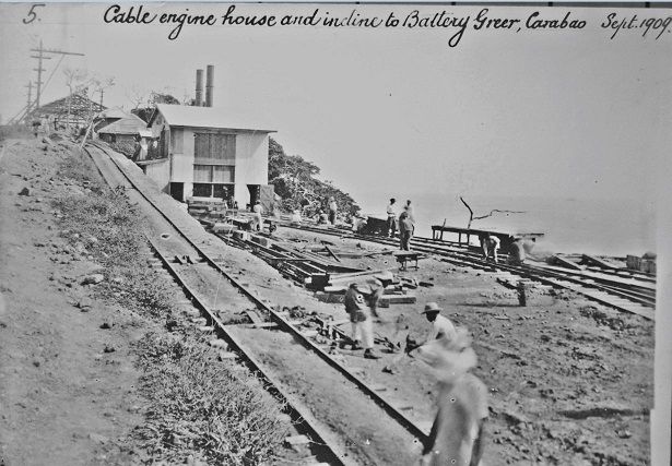 V297. (xPcon-127 77F-111-124-42 cable engine house,Greer 9-09). I believe we are looking north and up the incline to Battery Greer, for the future Fort Frank on Carabao Island. This image is from Karl Schmidt (CDSG.org) who got the images from (NARA). 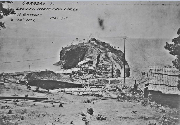 V298. (xPcon-131 77F-111-124-16 Ft look. north fm. Crofton 5-09). This picture is very similar than the image xPcon-062 SB but it shows a few different features. This view is looking north towards Battery Greer from sitting south and above the excavation area of Battery Koehler. This is on Carabao Island in Manila Bay and the picture description dated this picture May 1st 1909. This image is from Karl Schmidt (CDSG.org) who got the images from (NARA). 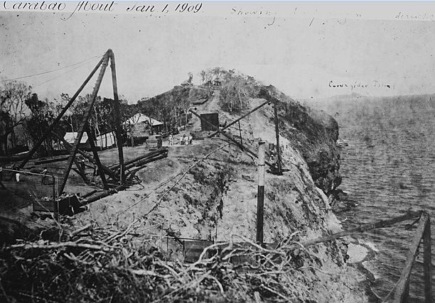 V299. (xPcon-143 77F-111-124-6 Ft Frank Greer 1-1-09). This picture is not completely clear to me but we are looking north and Caballo Island is in site although it is labeled wrongly as Carabao Island. This is on Carabao Island in Manila Bay and the picture description dated this picture Jan. 1st 1909. This image is from Karl Schmidt (CDSG.org) who got the images from (NARA). 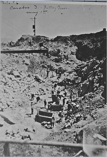 V300. (xPcon-144 77F-111-124-19 Ft Frank Greer 5-1-09). This is really the only picture of the actual excavation of Battery Greer and the description dates it at 1st May 1909. This is on Carabao Island in Manila Bay site of the future Fort Frank. This image is from Karl Schmidt (CDSG.org) who got the images from (NARA). |
|
|
|
Post by Karl Welteke on Oct 25, 2016 17:06:05 GMT 8
Workers, machines and views Fort Frank on Carabao Island under construction, workers, machines and views This entry shows Carabao Island under construction, workers, machines and views in Fort Frank on Carabao Island in Manila Bay. Fort Frank was part of the Manila and Subic Bay Harbor Defense Command. These 10 images were given to me by Karl Schmidt from the Coastal Defense Study Group (CDSG.org) who got the images from National Archives and Records Administration (NARA). Thank you Karl and all members of the CDSG. These 10 pictures and 1 Carabao Island photo from a distance were uploaded at a high resolution into this Flickr album. I put the letter e01 to e10 in front of the original number of the image so the pictures will end up more to the end of the album, the pictures are numbered e01 to e10 and the island shot as 03: www.flickr.com/photos/44567569@N00/albums/72157673964028162More pictures of the Fort Frank construction will follow. Here, in the forum, are the same 10 pictures and 1island shot but are much smaller. 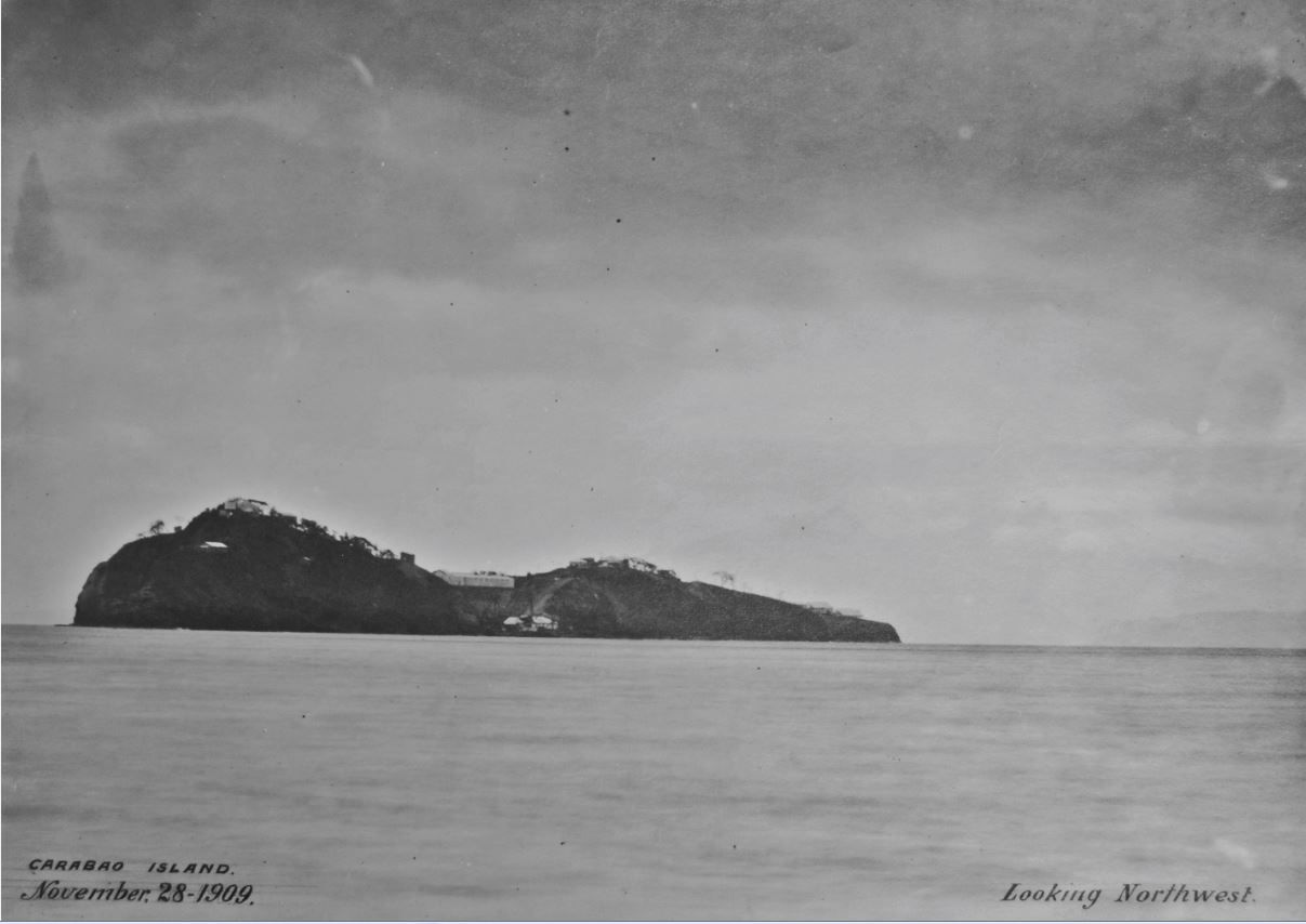 V309. (03 Pcon-146 77F-111-124-65 Ft Frank 11-28-09). View of Carabao Island on the 28th Nov. 1909 and the view is from the Cavite shores in a north-west direction. This image is from Karl Schmidt (CDSG.org) who got the images from (NARA). 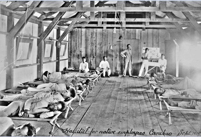 V310. (e01 Pcon-115 77F-111-124-46 Ft Frank hospital for native employees 9-09). The clinic and sickbay for the many workers, building the batteries and facilities for the future Fort Frank on Carabao Island. This image is from Karl Schmidt (CDSG.org) who got the images from (NARA). 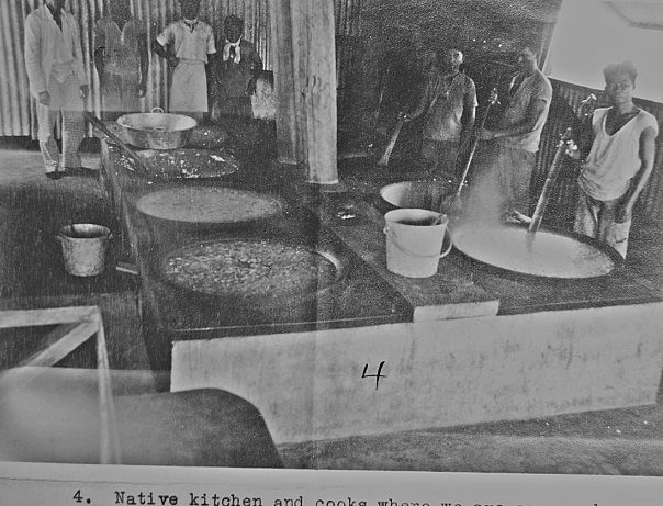 V311. (e02 Pcon-147 77F-111-124-13 Ft Frank native kitchen 5-1-09). The kitchen facility for the many workers, building the batteries and facilities for the future Fort Frank on Carabao Island. This image is from Karl Schmidt (CDSG.org) who got the images from (NARA). 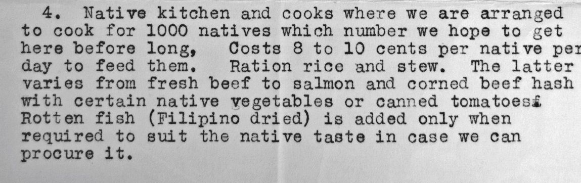 V312. (e03 Pcon-148 77F-111-124-13 Ft Frank native kitchen 5-1-09). A description of the feeding arrangement for the many workers, building the batteries and facilities for the future Fort Frank on Carabao Island. This image is from Karl Schmidt (CDSG.org) who got the images from (NARA). 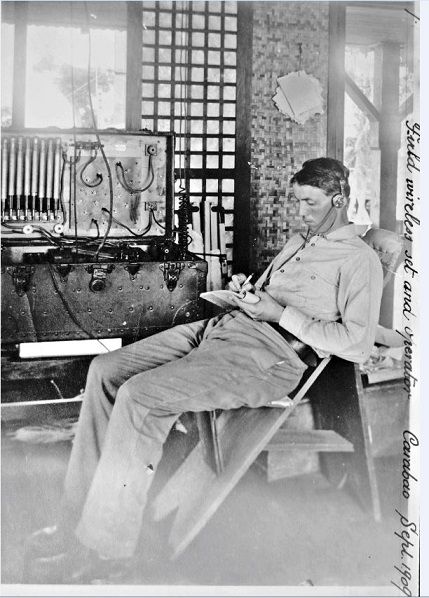 V313. (e04 Pcon-123 77F-111-124-44 Ft Frank field wireless set 9-09). The Radio Man, that is what we call him today perhaps. I am sure he played an important role transmitting the needs of this project to the support activity in Manila or elsewhere. This is on Carabao Island in Manila Bay building Fort Frank. This image is from Karl Schmidt (CDSG.org) who got the images from (NARA). 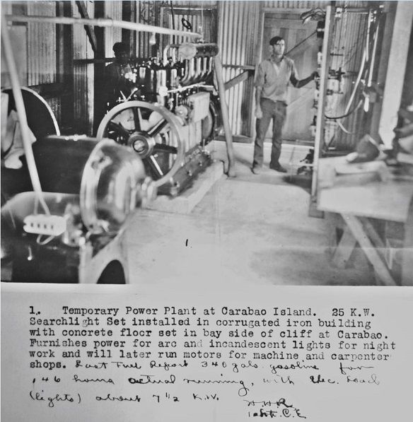 V314. (e05 Pcon-121 77F-111-124-11 Ft Frank temporary 25kw power plant). This is the temporary power plant for the process of building the batteries and facilities for the future Fort Frank on Carabao Island. This image is from Karl Schmidt (CDSG.org) who got the images from (NARA). 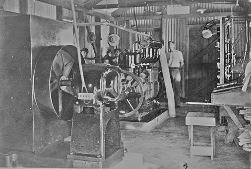 V315. (e06 Pcon-112 77F-111-124-45 Ft Frank electric plant 9-09). This is a more permanent power plant but it must be just for building the batteries and facilities for the future Fort Frank on Carabao Island. Once the fort is complete, the power plant must be under concrete. This image is from Karl Schmidt (CDSG.org) who got the images from (NARA). 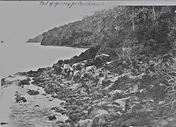 V316. (e07 Pcon-139 77F-111-124-39 Quarry at Ternate Frank and Drum 9-09). About at the same place exists an abandoned quarry which is about3 ½ km south of the Carabao Wharf on the Cavite shore. This image is from Karl Schmidt (CDSG.org) who got the images from (NARA). 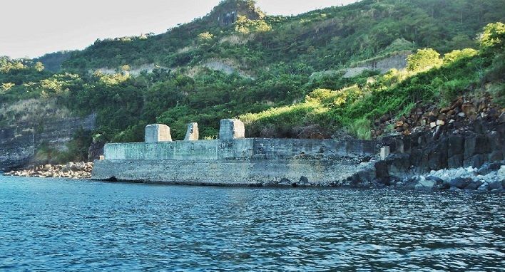 V317. (e08 121123a coast,S-Mercedes to Carabao.01). That is how the abandoned quarry looks like now. Fots2 and I were on our way to Carabao Island from Santa Mercedes Village when we shot this image of the quarry. Photo source is Karl Welteke. 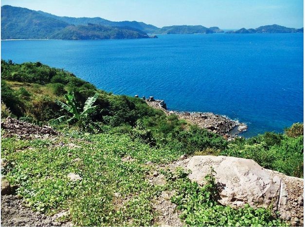 V318. (e09 121122b to Tnl. .04a,quarry). Here is a shot of the abandoned quarry site from the new road that runs thru a new tunnel from Ternate to Nasugbu. We are looking across the Patungan Cove, which is the name on one of my maps. Across the cove and at right is the Limbones Island. Photo source is Karl Welteke. 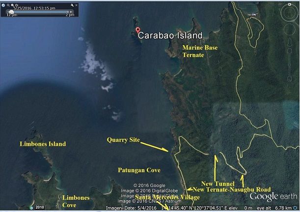 V319. (e10 Google Earth map around Carabao Island). This is a Google Earth map of Carabao Island and the area around it. It shows the location of the quarry which is about 3 ½ km distance to the Carabao Island wharf landing. |
|
|
|
Post by fortman on Oct 26, 2016 0:15:54 GMT 8
More great info from Karl! Many thanks.
Fortman
|
|
|
|
Post by Karl Welteke on Oct 29, 2016 12:21:56 GMT 8
Tram locomotive, equipment and buildings 7 pictures uploaded to Flickr. This is the 5th effort and these pictures show the tram locomotive, equipment and buildings This entry shows Carabao Island under construction, tram locomotive, equipment and buildings in Fort Frank on Carabao Island in Manila Bay. Fort Frank was part of the Manila and Subic Bay Harbor Defense Command. These 7 images were given to me by Karl Schmidt from the Coastal Defense Study Group (CDSG.org) who got the images from National Archives and Records Administration (NARA). Thank you Karl and all members of the CDSG. These 7 pictures were uploaded at a high resolution into this Flickr album. I put the letter d1 to d7 in front of the original number of the image so the pictures will end up more to the middle of the album; the pictures are numbered d1 to d7. www.flickr.com/photos/44567569@N00/albums/72157673964028162More pictures of the Fort Frank construction will follow. Here, in the forum, are the same 7 pictures but are much smaller. 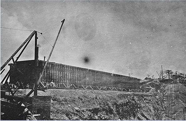 V324. (d1 Pcon-133 77F-111-124-29 Ft Frank sand bin 8-11-09). This picture calls this building the sand bin and was important for building the batteries and facilities for the future Fort Frank on Carabao Island. This image is from Karl Schmidt (CDSG.org) who got the images from (NARA). 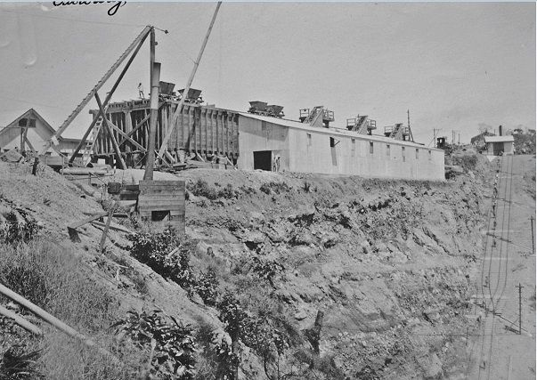 V325. (d2 Pcon-126 77F-111-124-40 Ft Frank cableway, cement house 9-09). This picture says cement house and it seems to be attached to the sand bin structure. The image was shot in Sep1909. Sand and cement was certainly important material for building the batteries and facilities for the future Fort Frank on Carabao Island. This image is from Karl Schmidt (CDSG.org) who got the images from (NARA). 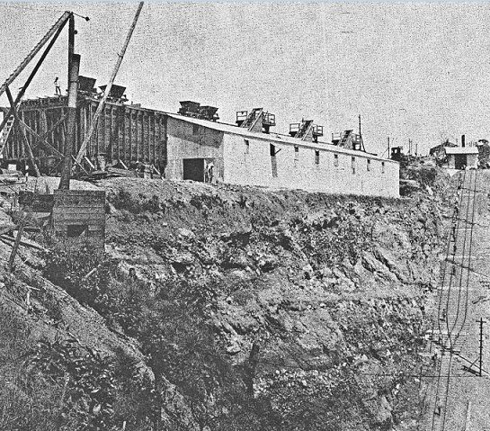 V326. (d3 Pcon-058 SB Ft Frank new incline). This picture is almost the same as the last image but it is little closer zoomed in. The picture say new incline and we can assume they just finished new tracks for the tram to go up from the wharf area. This picture also gives us a good idea how they mixed the concrete and transported it to everywhere. This was a neat way of building the batteries and facilities for the future Fort Frank on Carabao Island. This image is from Karl Schmidt (CDSG.org) who got the images from (NARA). 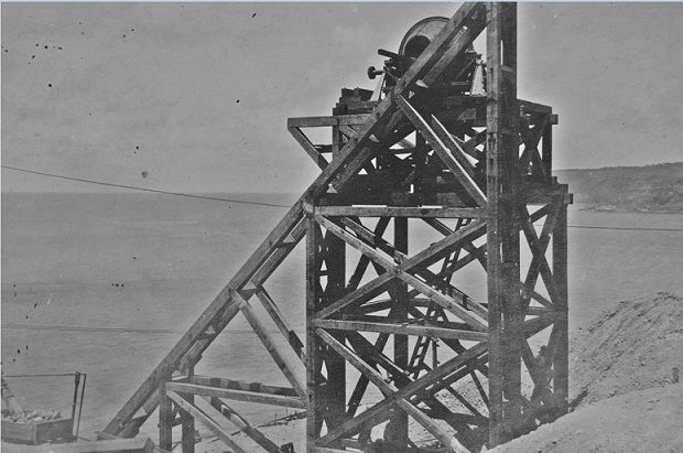 V27. (d4 Pcon-134 77F-111-124-30 Ft Frank construction tower 8-11-09). This seems to be a cement mixer. We see the Cavite shore in back. At left, bottom corner, we see a box loaded with rocks and one of the boom rigging supports is anchored that way. All this was for building the batteries and facilities for the future Fort Frank on Carabao Island. This image is from Karl Schmidt (CDSG.org) who got the images from (NARA). 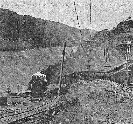 V328. (d5 Pcon-061 SB Ft Frank incline and bridge). In this picture this building is called the bridge. It seems to be the sand bin building in the previous pictures and the tower in the back seems to be used for mixing concrete to build this building. This is above the wharf area below and left of this building and we see the Cavite shore in the SE direction. This building does bridge the high areas south and north on the island. They not only used cable winches; it seems they also used regular tram locomotives. All this was for building the batteries and facilities for the future Fort Frank on Carabao Island. This image is from Karl Schmidt (CDSG.org) who got the images from (NARA). 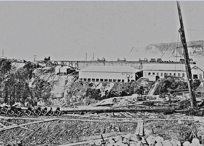 V329. (d6 Pcon-063 SB Ft Frank construction storage bins 9-01-1909). This shot is obviously from the Battery Crofton construction site and we are looking east. I think now we can see clearly why the sand and cement building was called a bridge in the previous picture. All this was for building the batteries and facilities for the future Fort Frank on Carabao Island. This image is from Karl Schmidt (CDSG.org) who got the images from (NARA). 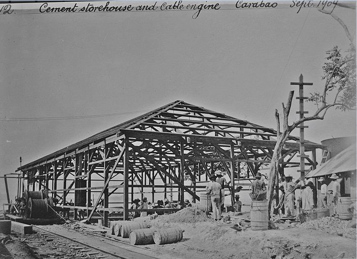 d7 Pcon-119 77F-111-124-49 Ft Frank cement storehouse and cable engine 9-09. What I find interesting in this picture are the many wooden drums and this picture seems to show a water tank. I am sure they used a lot of water and I have a hunch, that like later in Fort Frank, the water was piped or hosed from a dam at a near Cavite valley. All this was for building the batteries and facilities for the future Fort Frank on Carabao Island. This image is from Karl Schmidt (CDSG.org) who got the images from (NARA). |
|
|
|
Post by cbuehler on Oct 30, 2016 23:55:06 GMT 8
I presume that quarry was used for the construction of all the island fortresses at the time? I wonder if it was only for that purpose or what?
As an aside, I must say that every time the subject of this area along the coast comes up, it leads me to wonder wear the Japanese artillery was located during the siege prior to being moved to Bataan.
The vast majority of this area from Ternate on down is mountainous and I doubt there was much, if anything, in the way of good roads there during the war. We do know that the Japanese frequently shifted the location of their guns to avoid counter battery fire (which was very effective as there seems to have been little success in this), and they even had the big 240s there. Cant imagine how they managed to get those monsters around in this area.
Ft. Frank is so close to the mainland that it obviously stood no chance from an attack from the mainland.
I might also add that when we were on Ft. Frank in 2012, I found it very difficult to get a good sense of the layout and setup of the whole area. It is so densely overgrown with vegetation and so difficult in getting around on foot that it is hard to relate to these photos.
CB
|
|
|
|
Post by fortman on Oct 31, 2016 3:30:08 GMT 8
I think that in the case of Corregidor the quarry was on the west side of Malinta Hill, where the tunnel was later excavated. The large gash on the side of the hill can only be due to quarrying. It would have been a major logistic exercise to move hundreds of tons of rock across the bay from Ternate. Fort Drum's concrete aggregate could well have come from Ternate, however. Any views BBoy?
Fortman
|
|
|
|
Post by Karl Welteke on Nov 1, 2016 17:42:39 GMT 8
Carabao Island Wharf Construction 7 pictures uploaded to Flickr. This is the 6th effort and these pictures show the construction of the wharf and one more picture of the quarry. This entry shows Carabao Island under construction, the wharf and one more picture of the quarry in Fort Frank on Carabao Island in Manila Bay. Fort Frank was part of the Manila and Subic Bay Harbor Defense Command. Six (6) images were given to me by Karl Schmidt from the Coastal Defense Study Group (CDSG.org) who got the images from National Archives and Records Administration (NARA). Thank you Karl and all members of the CDSG. One current picture is from me. These 7 pictures were uploaded at a high resolution into this Flickr album. I put the letter c1 to c7 in front of the original number of the image so the pictures will end up more to the front of the album; the pictures are numbered c1 to c7. www.flickr.com/photos/44567569@N00/albums/72157673964028162These are the last pictures of Fort Frank under construction from me but I will post one more set of post WWII images. Here, in the forum, are the same 7 pictures but are much smaller. 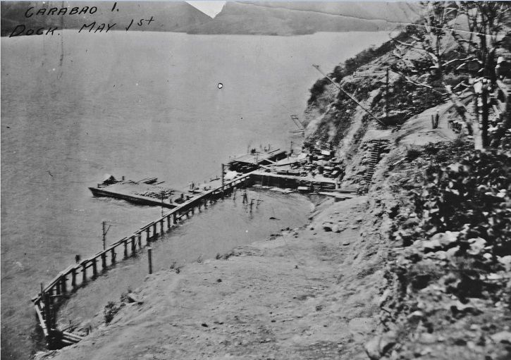 V332. (c1 Pcon-149 77F-111-124-14 Ft Frank dock area 5-1-09). The description is dated 1st of May 1909; this is the start of the construction of Fort Frank on Carabao Island in Manila Bay. Of course they had to start with a dock or wharf. This image is from Karl Schmidt (CDSG.org) who got the images from (NARA). 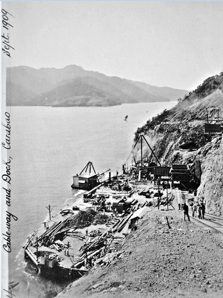 V333. (c2 Pcon-120 77F-111-124-41 Ft Frank cableway and dock 9-09). This image is dated Sep. 1909, about 5 month later from the previous picture. Considerable progress has been made building the dock or wharf. This image is from Karl Schmidt (CDSG.org) who got the images from (NARA). 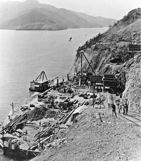 V334. (c3 Pcon-064 77F-111-124-41 Ft Frank wharf and dock 9-1909). This is almost the same shot as the previous one and it is zoomed in a little. This image is from Karl Schmidt (CDSG.org) who got the images from (NARA). 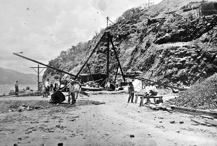 V335. (c4 Pcon-135 77F-111-124-25 Ft Frank dock and incline 8-11-09}. This is really a close up of the dock/ wharf area. The derrick is in place and I notice a man with shirt and tie. In all these pictures, everybody is wearing long pants and a wide brimmed hat. This image is from Karl Schmidt (CDSG.org) who got the images from (NARA). 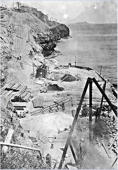 V336. (c5 Pcon-151 77F-111-124-23 Ft Frank wharf and cableway 8-11-09). This picture of the dock/wharf is in the other direction; we see Caballo Island in the back. The incline for the cable tram track is prepared and the tracks are being laid down. They did take precaution for drainage with this incline project. The date of this picture may be 8th Nov.1909. This image is from Karl Schmidt (CDSG.org) who got the images from (NARA). 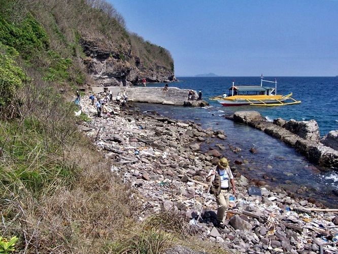 V337. (c6 060304c,Ft Frank Warf # 7). This picture is in the same direction as the last image but it is 97 years later; it was shot 4th of Mar. 2006. The man in front is EXO the webmaster of Corregidor.org. He and I were able to tag along with this group of visitors from the Coastal Defense Study Group (CDSG.org). We can see Caballo Island in back again and let me tell you it is physical difficult to visit Carabao Island with a banca boat because of the outriggers. This photo was shot by this Karl-Wilhelm. Funny, Karl Schmidt also has the middle name of Wilhelm, the only other person I ever met who has the same first names like me. 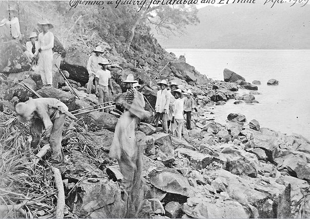 V338. (c7 Pcon-139 77F-111-124-38 Ternate quarry for Frank and Drum 9-09). This is another image of the quarry that was used for the construction of Fort Frank and Fort Drum. It is located about 3.5 km south of the Carabao Island wharf along the Cavite shore and is part of the town of Ternate. This seemed to be a hard place to start a quarry only with hand tools. One man is wearing a striped shirt, was he a criminal prisoner from the civilian justice system? This image is from Karl Schmidt (CDSG.org) who got the images from (NARA). |
|


