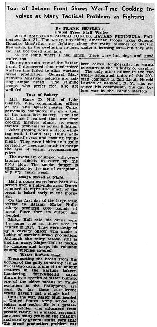
Post by chadhill on Jun 19, 2019 11:34:19 GMT 8
The following map was originally posted six years ago on the “Battle of the Pockets” thread by Bob Hudson, and later by me on the "Death March Markers" thread where it was discussed to some extent (see the link at the beginning of this thread). It has also been posted on Facebook by Bob. A group of US Marines were hiking in the Pantingan River area during the late 1970s and came upon over one hundred human bones in the river bed. They gathered the remains, buried them on the side of the river, and erected a cross at the grave location, which they marked with a large “X” on this map.
(courtesy of Bob Hudson)
Z124
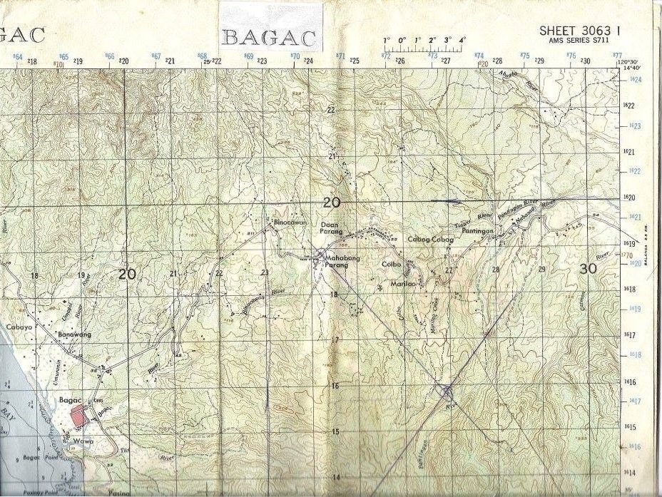
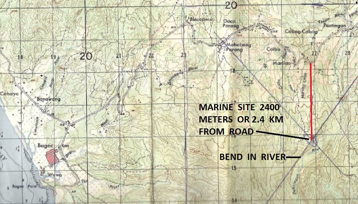
The marine map is Sheet 3063 l from AMS Series S711. I have not been able to locate a full size copy of the Bagac chart, but have found several other Bataan sheets from this series. They appear to have been printed beginning in the early 1960s, and are based on 1950s surveys and information. The grid squares are 1000 meters, not yards as on the 1944 AMS map shown before.
Below is a slightly blurred, enlarged section from the map. Note that the “X” intersection is approximately 2400 meters or 2.4 km due south of the curve indicated on the Pilar–Bagac road, and is just north of a faintly visible bend in the Pantingan River.
Z125
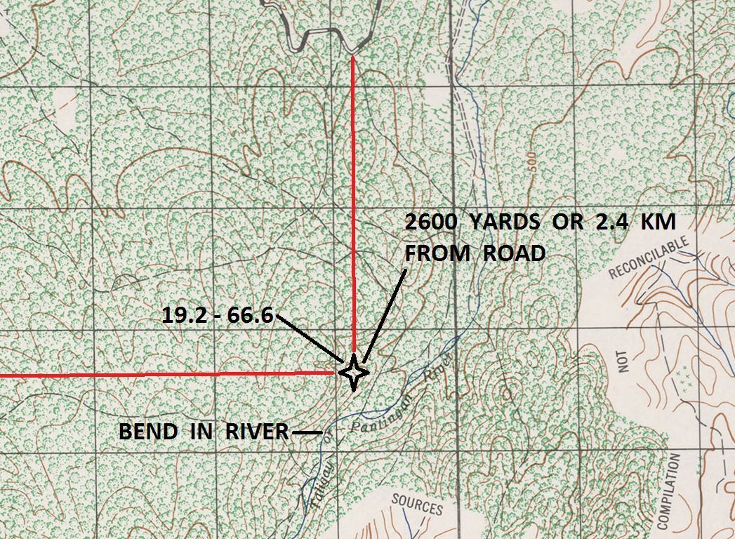
Here is a clearer depiction of the area, enlarged from the 1944 AMS Sheet 3254-IV that I have used before. I had to convert to yards for this chart, and 2.4 km is just over 2600 yards. For future reference I have extrapolated a grid coordinate of 19.2 – 66.6 from the 1944 chart for the X on the marine map. Note that this point falls about 400 yards north of the river bend.
Z126
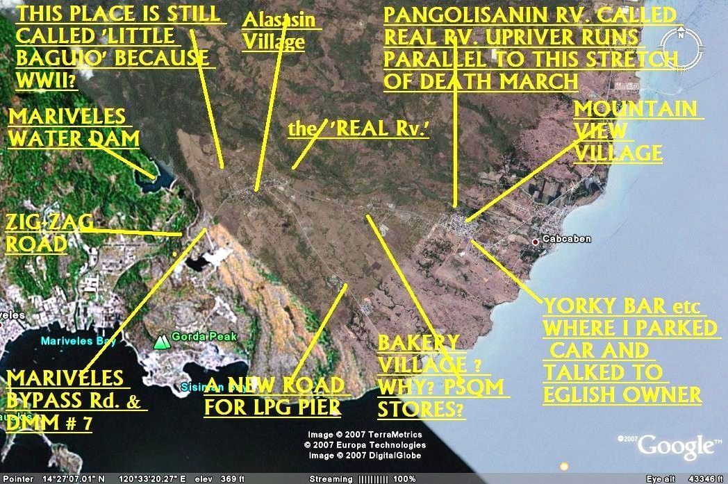
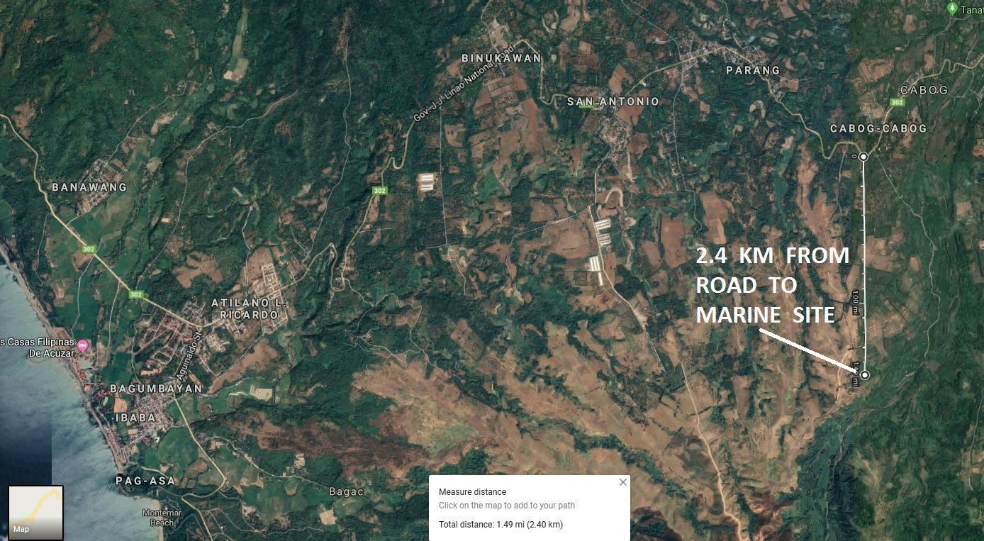
Below is a Google satellite map photo with a line extending 2.4 km due south from the curve referenced on the Pilar-Bagac road. The Google satellite distance calculation of 2.4 km can be seen in the white box at the bottom.
Z127
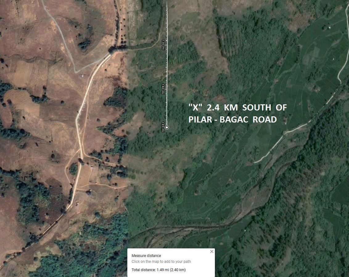
Here is a closer view of the area where the marines buried the remains, approximately 2.4 km south of the Pilar-Bagac road.
Z128
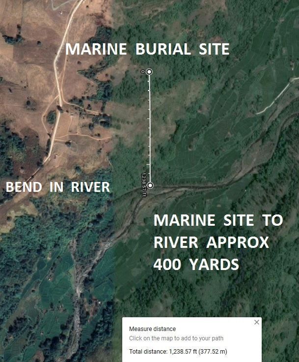
Seen below, the Google computer calculates the burial area to be a distance of 377 meters, or just over 400 yards, north of the river. Note the round bend in the river, which was depicted on the maps. Of course, I have no idea where in the river bed the bones were found.
Z129
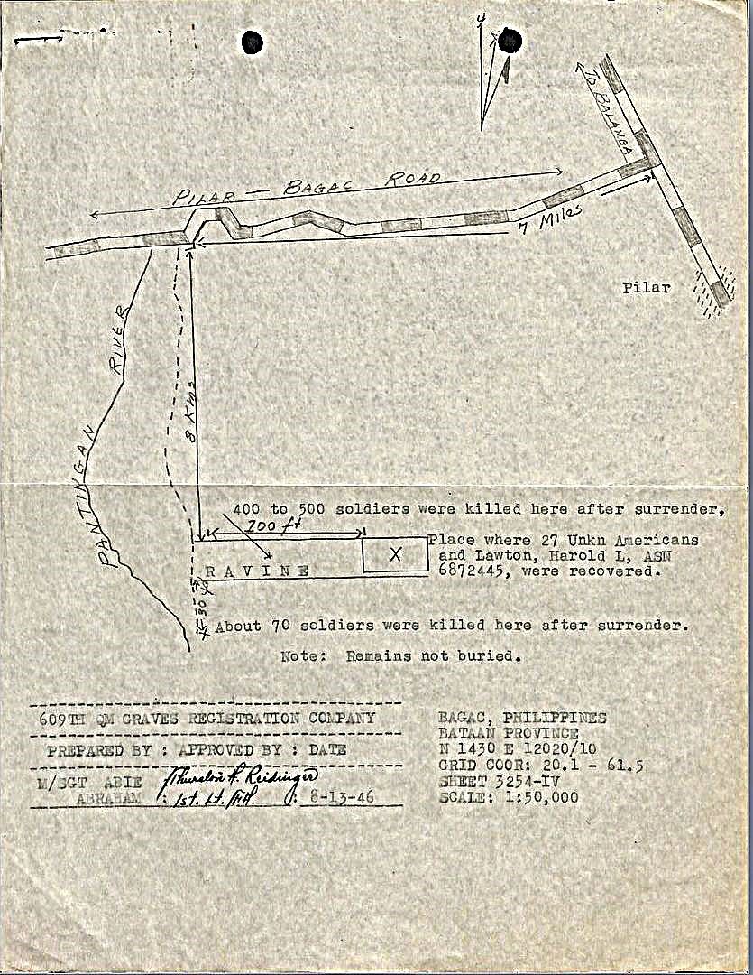
Several accounts (Capt Pedro Felix's, for example) state that as the POWs were marched from the 1st Corps sector to the 2nd Corps sector, they encountered a broken bridge over the Pantingan River which they were forced to repair. Although several maps show the general location of that bridge, I have wondered exactly where it might have been. The marine map may have helped solve that mystery.
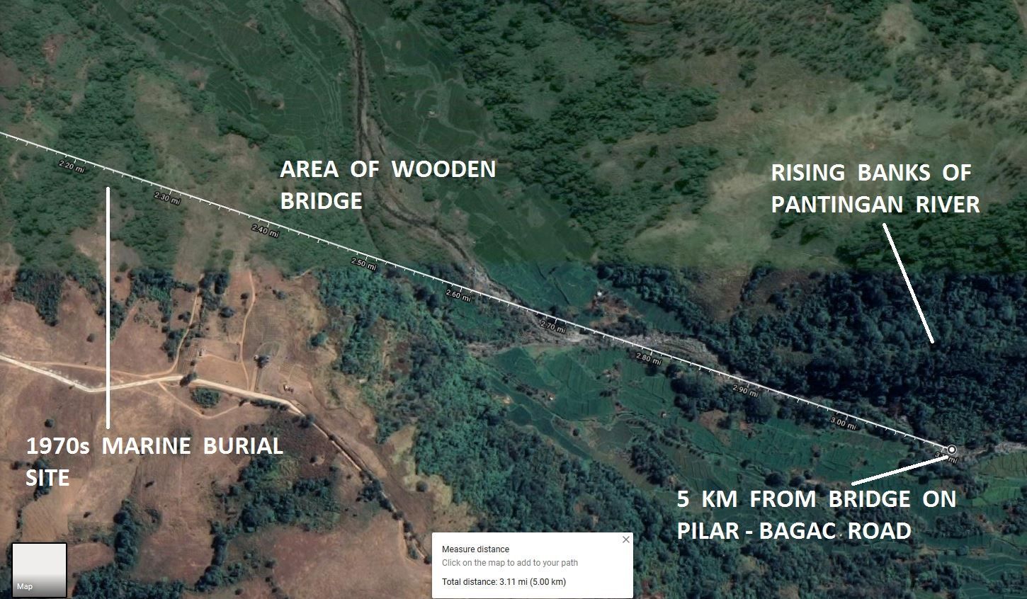
Fidel L. Ongpauco (LtCol AFP, ret.) was a 1st Lt in C Company, 1st Battalion, 2nd Infantry Regiment (PC) on Bataan, and later became a historian of the 11th Division. Although he was not a victim of the massacre, he did write of it in his 1982 book, “They Refused to Die”. Ongpauco stated that along the Pantingan River about 5 km south of the Pilar-Bagac road “...the banks rise steeply. There once crossed at this point a military trail which dipped down from a bend of that trail to a wooden bridge below and rose to the other bank...”. This would be the Trail 8 bridge that would eventually lead to Trail 29 and beyond.
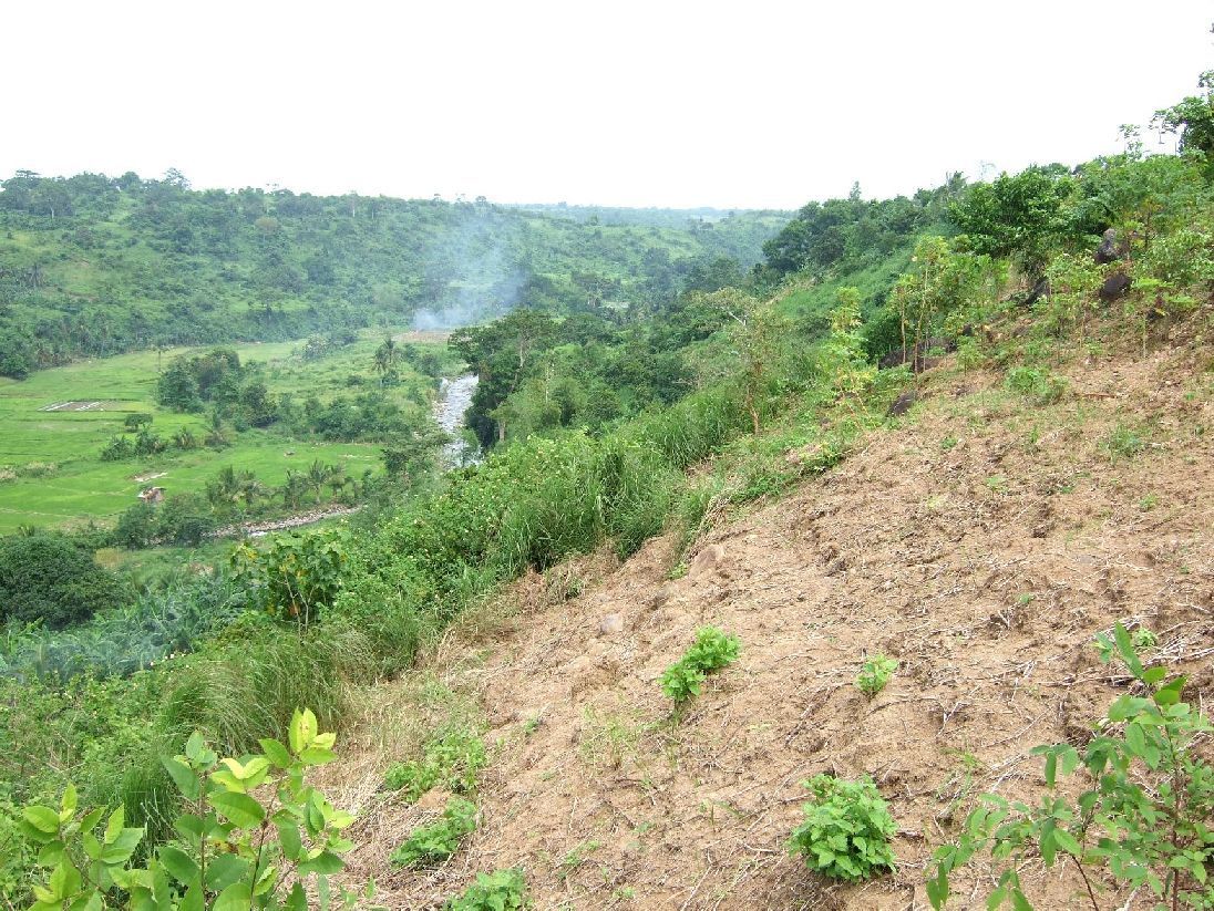
Curious, I plotted a point on the Pantingan River 5 km south of the Pilar-Bagac road using Google satellite maps. As you can see from the photo below, the banks of the river do indeed begin to rise sharply at that distance. Preceding that rising terrain is a much flatter area suitable for a bridge. And most interestingly, this is the area where the human remains were discovered by the marines during the 1970s.
The area as seen from the west.
Z130
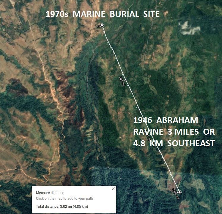
Finally, here is a Google satellite photo showing the area of the 1970s marine site and the ravine that I believe Abraham excavated in 1946. The ravine is approximately 3 miles or 4.8 km southeast of that site.
Z131
Conclusion: I will certainly admit up front that my calculations for the location of the marine site could be off by a couple hundred yards or so. Factors would be the accuracy of the “X” that was hand drawn on the map, as well as rounding errors on my part when plotting the points on the charts or on Google satellite maps. Although I did not present the work here, I cross checked the Google satellite points with grid coordinates I plotted on the 1944 AMS map and everything seemed to agree. A sharp eye would notice that the marine map was very slightly crooked when it was originally scanned, and I was not able to correct this.
Some Philippine accounts say that the Pantingan Massacre occurred over more than one day, and happened in more than one location along the river. The marine map “X” may offer support for that. However, a hundred bones could represent the remains of only a few men, or they could be all that was left of a much larger group after being scattered by the elements for more than three decades. The Japanese made a determined penetration down nearby Trail 29 during the final days of Bataan, and there was significant fighting in this area. But finding remains near the possible former site of the bridge where hundreds of doomed POWs crossed has significance, too.
(courtesy of Bob Hudson)
Z124
The marine map is Sheet 3063 l from AMS Series S711. I have not been able to locate a full size copy of the Bagac chart, but have found several other Bataan sheets from this series. They appear to have been printed beginning in the early 1960s, and are based on 1950s surveys and information. The grid squares are 1000 meters, not yards as on the 1944 AMS map shown before.
Below is a slightly blurred, enlarged section from the map. Note that the “X” intersection is approximately 2400 meters or 2.4 km due south of the curve indicated on the Pilar–Bagac road, and is just north of a faintly visible bend in the Pantingan River.
Z125
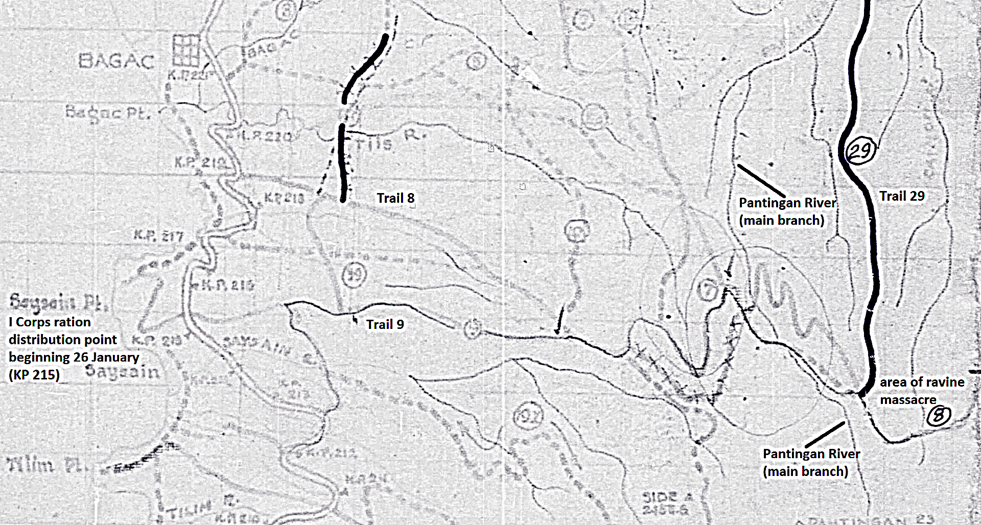
Here is a clearer depiction of the area, enlarged from the 1944 AMS Sheet 3254-IV that I have used before. I had to convert to yards for this chart, and 2.4 km is just over 2600 yards. For future reference I have extrapolated a grid coordinate of 19.2 – 66.6 from the 1944 chart for the X on the marine map. Note that this point falls about 400 yards north of the river bend.
Z126
Below is a Google satellite map photo with a line extending 2.4 km due south from the curve referenced on the Pilar-Bagac road. The Google satellite distance calculation of 2.4 km can be seen in the white box at the bottom.
Z127
Here is a closer view of the area where the marines buried the remains, approximately 2.4 km south of the Pilar-Bagac road.
Z128
Seen below, the Google computer calculates the burial area to be a distance of 377 meters, or just over 400 yards, north of the river. Note the round bend in the river, which was depicted on the maps. Of course, I have no idea where in the river bed the bones were found.
Z129
Several accounts (Capt Pedro Felix's, for example) state that as the POWs were marched from the 1st Corps sector to the 2nd Corps sector, they encountered a broken bridge over the Pantingan River which they were forced to repair. Although several maps show the general location of that bridge, I have wondered exactly where it might have been. The marine map may have helped solve that mystery.
Fidel L. Ongpauco (LtCol AFP, ret.) was a 1st Lt in C Company, 1st Battalion, 2nd Infantry Regiment (PC) on Bataan, and later became a historian of the 11th Division. Although he was not a victim of the massacre, he did write of it in his 1982 book, “They Refused to Die”. Ongpauco stated that along the Pantingan River about 5 km south of the Pilar-Bagac road “...the banks rise steeply. There once crossed at this point a military trail which dipped down from a bend of that trail to a wooden bridge below and rose to the other bank...”. This would be the Trail 8 bridge that would eventually lead to Trail 29 and beyond.
Curious, I plotted a point on the Pantingan River 5 km south of the Pilar-Bagac road using Google satellite maps. As you can see from the photo below, the banks of the river do indeed begin to rise sharply at that distance. Preceding that rising terrain is a much flatter area suitable for a bridge. And most interestingly, this is the area where the human remains were discovered by the marines during the 1970s.
The area as seen from the west.
Z130
Finally, here is a Google satellite photo showing the area of the 1970s marine site and the ravine that I believe Abraham excavated in 1946. The ravine is approximately 3 miles or 4.8 km southeast of that site.
Z131
Conclusion: I will certainly admit up front that my calculations for the location of the marine site could be off by a couple hundred yards or so. Factors would be the accuracy of the “X” that was hand drawn on the map, as well as rounding errors on my part when plotting the points on the charts or on Google satellite maps. Although I did not present the work here, I cross checked the Google satellite points with grid coordinates I plotted on the 1944 AMS map and everything seemed to agree. A sharp eye would notice that the marine map was very slightly crooked when it was originally scanned, and I was not able to correct this.
Some Philippine accounts say that the Pantingan Massacre occurred over more than one day, and happened in more than one location along the river. The marine map “X” may offer support for that. However, a hundred bones could represent the remains of only a few men, or they could be all that was left of a much larger group after being scattered by the elements for more than three decades. The Japanese made a determined penetration down nearby Trail 29 during the final days of Bataan, and there was significant fighting in this area. But finding remains near the possible former site of the bridge where hundreds of doomed POWs crossed has significance, too.