|
|
Post by fots2 on Dec 19, 2010 9:24:01 GMT 8
No problem okla. Minor side affect of our addiction. ;D
|
|
|
|
Post by chadhill on Dec 20, 2010 7:22:12 GMT 8
Nice photos of your hikes, Fots and Armyjunk. I slipped and nearly fell down the side of Malinta during one of my trips long ago. Beautiful aerial view of Malinta Hill, too, Fots. You do a very nice job helping those of us in far away places visualize your journeys. I wonder if any artifacts might be found in those foxholes. I looked in a few during the 80s but didn't find anything worth remembering. Here are 1986 aerial views I took of the north side of Malinta which show just how treacherous Fots' climb down Malinta could have been had he taken a wrong step! 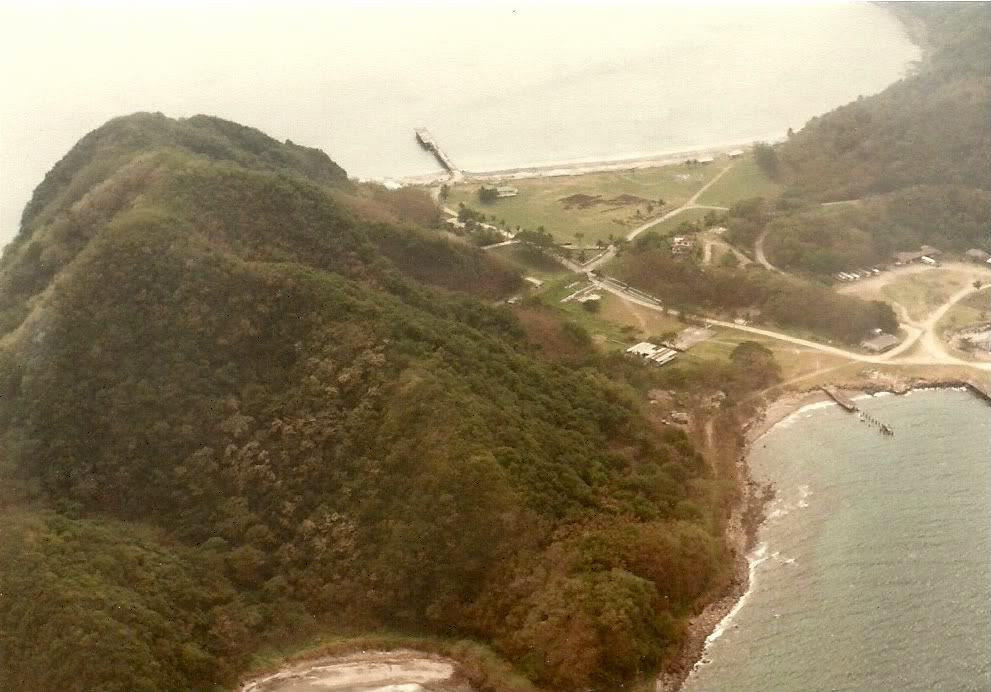 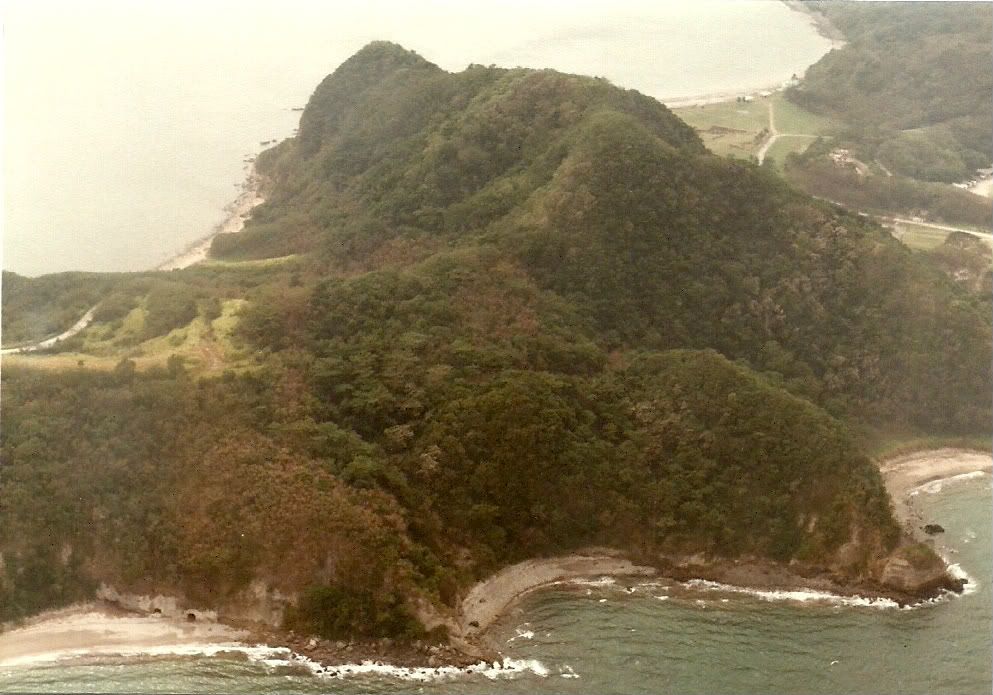 Okla, on April 24th at 9:58 p.m. a 240mm shell exploded outside the west entrance of Malinta Tunnel, killing 14 and wounding 70. The group had gathered outside for an evening smoke in violation of standing orders. According to the Belotes in "Saga" on page 120, there were two shells that hit, one a dud. Tunnel hospital nurse Juanita Redmond, in "I Served on Bataan", page 144, says both shells exploded. The first one blew the gate shut, the second landed in the crowd. 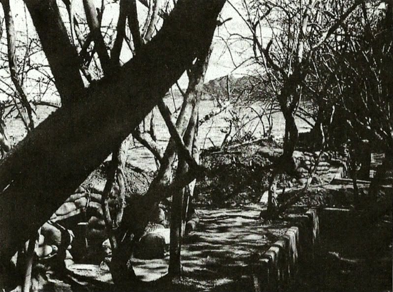 Repost of USMC concrete trench photo. I've been browsing thru the late Otis King's privately published memoirs, "Alamo of the Pacific". He was with L Company, 3rd Batallion, 4th Marines and manned a .50 cal MG at Battery Point. The gun had been salvaged by the Navy from a wrecked PBY and handed over to the Marines. King walked along a beach trail at Battery Point "about 30 yards beyond a concrete trench at the left end (west end) of the company's defensive position", and mounted the .50 cal MG about 60 feet up the side of a cliff that looked like an "upside down nose" (pages 95-97). On the top of the cliff a "trap door led down into the ammo tunnel below". King notes that another .50 cal was mounted nearby and that "two .30 caliber water cooled machine guns occupied the concrete trench between the two .50s. The trench, part of a beach defense system that had been in place for years, boasted a concrete bunker for sheltering the company during artillery or bombing attacks". King says that an ammo tunnel above the company's position, full of 155mm shells, served as the HQ. A 36 inch search light was housed in a concrete bunker in the side of a hill next to the ammo tunnel. The searchlight was mounted on railroad tracks and could be moved. King's position survived the 1942 battle intact. On May 6th, after the surrender, he field stripped the .50 cal MG and threw the parts into the sea. I'm not trying to say that this photo was taken at Battery Point, although the shoreline seems to curve sharply like it would if looking to the east from there. But using the 1941 Emergency Defense map, I am having a hard time seeing that the ridge in the background might be Geary Point, as others have said. That would mean the photo would have to be looking SW. The shoreline seems to curve too sharply in the photo to be the shoreline NE of Geary Point. Just my two cents worth, and I haven't set foot on Corregidor since '88, so I could be wrong. |
|
|
|
Post by okla on Dec 20, 2010 8:02:38 GMT 8
Hey Chad...You mentioned Nurse Juanita Redmond. Have you ever seen a photo of her??? She was what some folks would call, "drop dead good looking". There is a pic of her somewhere on this website or maybe over on Vic's Philippine Scout forum. Also, there is a group picture of the group that left Corregidor by PBY just before the surrender. It was taken in Australia just after their arrival. I think this photo is in the excellent book, "Band of Angels". Some of the nurses left behind thought her "good looks" had some bearing on her being one of the nurses chosen for evacuation. Maybe "sour grapes", maybe not. Maybe somewhere in between. I guess women can be "catty" regardless of circumstances. Wife, fortunately, isn't looking over my shoulder as I type this yarn, as she sometimes does. Cheers.
|
|
|
|
Post by chadhill on Dec 20, 2010 8:43:26 GMT 8
The back cover of her 1943 book... 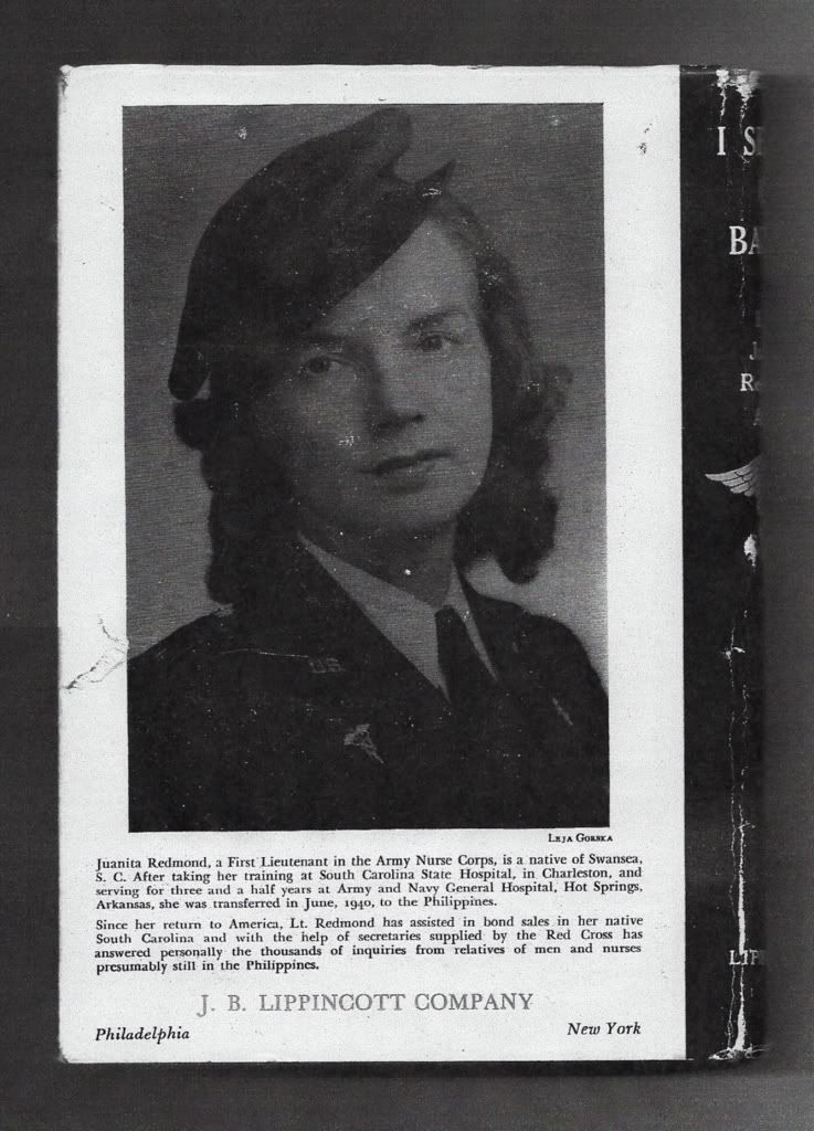 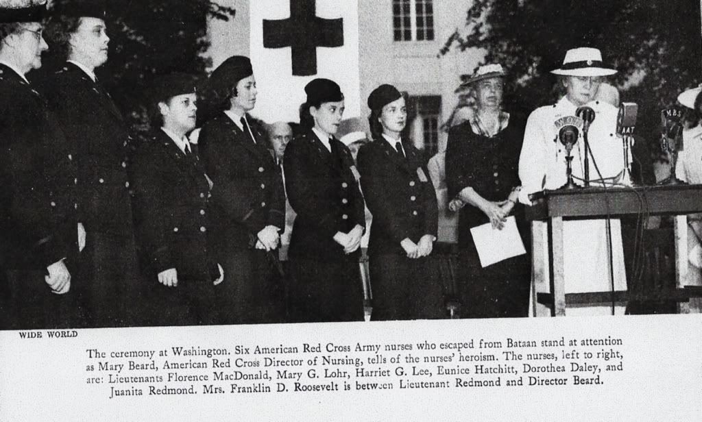 |
|
|
|
Post by okla on Dec 20, 2010 23:43:26 GMT 8
Hey Chad...Many thanks for posting. I would have probably lost what little bit of mind I have left searching for this photo on the web. I have never seen the second photo, although it is very similar to the one shown in the book, "Band of Angels". It was obviously taken at the same gathering/ceremony with Eleanor Roosevelt. I read Lieutenant Redmond's book during the summer of 1943 when it was featured in the now defunct magazine "Liberty" (in installments). I was eleven years old at the time. Reading her story just added to my developing "obession" with the Bataan/Corregidor saga. Who would have "thunk" that 67 years later that my fixation has not lessened one bit. To be quite honest, it has worsened. Ain't it fun?  Cheers. |
|
|
|
Post by fots2 on Dec 21, 2010 19:31:56 GMT 8
Hi Chad, Your north side Malinta photo shows very clearly the curve of the ridge from the top down to Malinta Point. Very good photo there. Hey okla, in Chad’s second photo near bottom left, notice some more Shinyo suicide boat tunnels. Speaking of air raids outside the Malinta Tunnel west entrance, here is a photo of one. They are sure in a hurry to get to the safety of the tunnel. “The group had gathered outside for an evening smoke in violation of standing orders”. (Note the “No Smoking” sign). 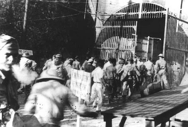 Regarding your Marines beach defense photo. I did not have time to look at it much in the past but you reminded me of it today. I looked it from the possibility of being (1) on the south side looking SW towards Geary Point and (2) on the north side looking E from Battery Point. I wish I could tell you for sure which of the two views we are looking at but I cannot be 100% sure. You may be correct. At Battery Point, maps do show an extensive trench system here along the beach. Dense grasses and trees hide it very well now. The searchlight at Battery Point was Searchlight #1. It was totally destroyed and only a bit of the tunnel still exists. I found pieces of thick rounded glass that was identified as from the light’s lens. I found a couple smaller structures near there but could not identify them. The big bombproof infantry quarters (similar to the one in James Ravine) is also totally destroyed. |
|
|
|
Post by okla on Dec 22, 2010 0:26:29 GMT 8
Hey Fots...I couldn't help but notice the GI on the extreme left exhaling his "last drag" before scrambling into the safety of Malinta. I say again....every time I get a close look into the face of any of these personnel, I always wonder if they "made it" or not. I have never seen this "air raid" photo. Thanks for posting. Cheers.
|
|
|
|
Post by chadhill on Dec 22, 2010 10:36:00 GMT 8
Ol' Hawkeye Okla spots another one!  Great photo, Fots! Is it dated? I see there are no sandbags. I entered those boat tunnels in the 80s and think I remember seeing bottles and little tins (like sardines are packaged in) scattered inside. The tins had Japanese letters stamped on them. It could be that I saw those in caves further towards Tailside, though. Here is a photo from the March-April 1945 issue of Coast Artillery Journal, captioned "West entrance to Malinta tunnel". What a difference a few years makes. 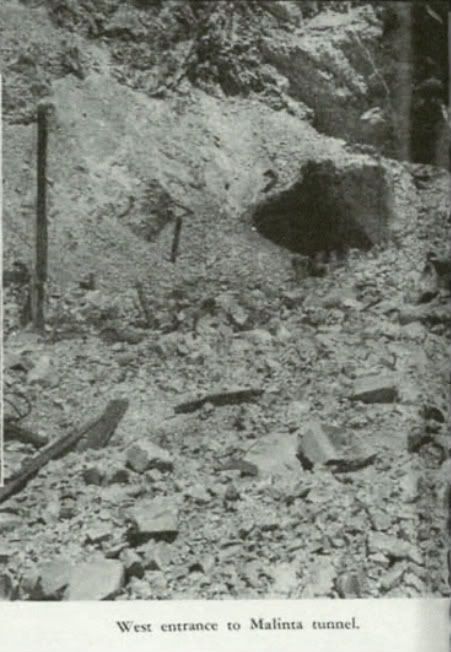 |
|
|
|
Post by okla on Dec 22, 2010 23:59:33 GMT 8
Hey Chad....I had no idea that the West Entrance of Malinta had taken such a battering during the 1945 liberation battle. As I get it both East and West entrances have been totally reconstructed. I also seem to remember reading/hearing that one of these portals was heavily damaged by an earthquake sometime after the late 1950s or 60s and rebuilt. Maybe it happened during your hitch in the 1980s. ? Considering bombings, shellings, typhoons, earthquakes,etc, the old "Rock" has held up fairly well during all the "beatings" she has taken thru the years, doncha think??? |
|
|
|
Post by okla on Dec 23, 2010 0:23:10 GMT 8
Hey Chad....In regard to the possible date of the photo depicting the GIs heading for the safety of Malinta during the Air Raid alert, I wonder if this raid might have been one of the very early "big raids" that began in the latter of part of December 1941. The intensity of the first raids might have triggered the installation of sandbagging soon after this pic was taken. Notice the overturned 55 galllon drum adjacent to the guy sporting the sun helmet. Wonder if it was knocked over in the scramble of the troops for the sanctuary of the tunnel. Some of these folks don't seem overly concerned by the oncoming danger, while others would appear to be in second gear heading for shelter. Who could blame them? ? |
|


 Cheers.