Post by chadhill on Feb 7, 2011 14:59:46 GMT 8
Wow Fots, you made my day! This was even better than having a bottle of Johnny Walker Green Label fished out of the sunken Cassiana ;D
Here's a 1986 aerial view showing the dense vegetation Fots speaks of near the beaches east of Kindley Field. Lieutenant Lawrence's positions began in the left half of the photo.
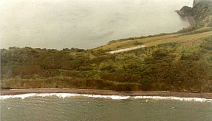
I know what you're speaking of when you mention all that growth. I posted a couple of 1980s photos in another thread where it was way over our heads, too.
Congratulations on finding this position of Lawrence's. It was no easy task, I'm sure. I ventured through there on two separate trips 25 years ago, searching for those positions, and did not find them. Looking at your crisp photos of the undisturbed sites, I wonder if you were possibly the first to find them since the war (the Graves Registration Company may have probed them in the late '40s). The island was seeded by air shortly after the war and as you know in that climate vegetation grows wild, concealing things very quickly.
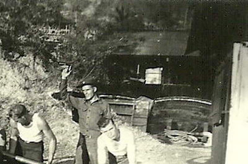
It would be interesting to know where on Corregidor that photo was taken of the 75mm gun anchored to the long circular rail. Lawrence mentions the circular rails in his 1963 letter to the Belotes.
For those who haven't read it, here's a link to Lawrence's letter. Be sure to click and read page 2:
corregidor.org/chs_lawrence/lawrence_1.htm
I've searched my library and the internet and have not found those guns attached to rails anywhere else. Often the tailpiece was spaded into the earth. Does anyone know if the circular rail was commonly used?
My guess is that the 75mm position you found is the "No. 1 gun" that Lawrence refers to in his Belote letter, since it would be the one which would have been on his left. The Scout shooting that weapon was a Corporal Navarro, and according to Lawrence the crew fired 580 rounds from that position.
Lawrence says that a platoon of marines manned the machine guns in his sector. This would have been the 3rd Platoon, Company A, 1st Battalion under First Sergeant Noble Wells. Any 30.06 cartridges still laying around today could be hard to see in that thick growth. Lawrence said they had 3000 grenades, too, and tossed all of them. Some were duds. Be careful if you go back.
Very interesting that there are two concrete rifle butt walls.
I wonder what that concrete box was for, that was dug out 12 feet deep. It was between the rifle butt walls and the gun position. Yes, maybe somebody has been looking for treasure in postwar years . That would explain the hole. But what about the squarish concrete walls? Was it a foundation for something? Just a wild guess on my part, but the Navy Radio Intercept unit had two radio direction finders, one southeast of Kindley Field and the other near East Point (see the "Intercept Station C" book, rough map page 32 and pages 61-65). They built a "battery shack" between them to recharge the RDF batteries with a Briggs and Stratton gas motor coupled to a DC generator, and according to the rough map on page 32 it could have been about where the 12 foot deep concrete box is. Again, a wild SWAG--
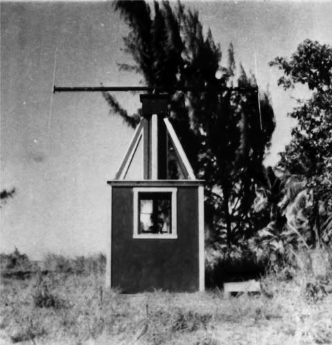
This is from the 1941 Emergency Defense Map:

The red arrow points to a triangle symbol NW of East Point, indicating an "observation post". This looks to be smack in the middle of Lawrence's 75mm guns, MGs and searchlight positions. The map on page 32 of "Intercept Station C" shows a DT HFDF radio direction finder in this area, and I'll bet it was was placed on the observation post.
Here is a photo of one:
Thanks for your research, exploration and photo posting, Fots. Really, really good job, all you guys!! Just when I thought this website couldn't get any better...
Here's a 1986 aerial view showing the dense vegetation Fots speaks of near the beaches east of Kindley Field. Lieutenant Lawrence's positions began in the left half of the photo.
I know what you're speaking of when you mention all that growth. I posted a couple of 1980s photos in another thread where it was way over our heads, too.
Congratulations on finding this position of Lawrence's. It was no easy task, I'm sure. I ventured through there on two separate trips 25 years ago, searching for those positions, and did not find them. Looking at your crisp photos of the undisturbed sites, I wonder if you were possibly the first to find them since the war (the Graves Registration Company may have probed them in the late '40s). The island was seeded by air shortly after the war and as you know in that climate vegetation grows wild, concealing things very quickly.
It would be interesting to know where on Corregidor that photo was taken of the 75mm gun anchored to the long circular rail. Lawrence mentions the circular rails in his 1963 letter to the Belotes.
For those who haven't read it, here's a link to Lawrence's letter. Be sure to click and read page 2:
corregidor.org/chs_lawrence/lawrence_1.htm
I've searched my library and the internet and have not found those guns attached to rails anywhere else. Often the tailpiece was spaded into the earth. Does anyone know if the circular rail was commonly used?
My guess is that the 75mm position you found is the "No. 1 gun" that Lawrence refers to in his Belote letter, since it would be the one which would have been on his left. The Scout shooting that weapon was a Corporal Navarro, and according to Lawrence the crew fired 580 rounds from that position.
Lawrence says that a platoon of marines manned the machine guns in his sector. This would have been the 3rd Platoon, Company A, 1st Battalion under First Sergeant Noble Wells. Any 30.06 cartridges still laying around today could be hard to see in that thick growth. Lawrence said they had 3000 grenades, too, and tossed all of them. Some were duds. Be careful if you go back.
Very interesting that there are two concrete rifle butt walls.
I wonder what that concrete box was for, that was dug out 12 feet deep. It was between the rifle butt walls and the gun position. Yes, maybe somebody has been looking for treasure in postwar years
 . That would explain the hole. But what about the squarish concrete walls? Was it a foundation for something? Just a wild guess on my part, but the Navy Radio Intercept unit had two radio direction finders, one southeast of Kindley Field and the other near East Point (see the "Intercept Station C" book, rough map page 32 and pages 61-65). They built a "battery shack" between them to recharge the RDF batteries with a Briggs and Stratton gas motor coupled to a DC generator, and according to the rough map on page 32 it could have been about where the 12 foot deep concrete box is. Again, a wild SWAG--
This is from the 1941 Emergency Defense Map:
The red arrow points to a triangle symbol NW of East Point, indicating an "observation post". This looks to be smack in the middle of Lawrence's 75mm guns, MGs and searchlight positions. The map on page 32 of "Intercept Station C" shows a DT HFDF radio direction finder in this area, and I'll bet it was was placed on the observation post.
Here is a photo of one:
Thanks for your research, exploration and photo posting, Fots. Really, really good job, all you guys!! Just when I thought this website couldn't get any better...


 You gotta be kidding. Busy yourself this minute. Cheers.