|
|
Post by fots2 on Jan 26, 2020 15:55:33 GMT 8
Paul,
You know that I live approximately a one hour drive from home to the Corregidor ferry terminal. It is quite easy to change my reservations to March, however, THAT WILL NOT HAPPEN for all the reasons you stated above.
Being one of the “handful” who joins you on February 16th, it will be great to continue the tradition with other like-minded friends. It will be great to meet Dick and his family again too.
See you next month.
fots2 |
|
|
|
Post by fots2 on Jan 10, 2020 17:23:18 GMT 8
Randy,
It is interesting to see these photos colorized.
Note that one slide which says"Eight 12-inch mortars in two pits of four guns each" is labeled as being Battery Way. Battery Geary would be correct.
Good job though.
|
|
|
|
Post by fots2 on Dec 2, 2019 20:40:28 GMT 8
Chad,
Please accept my sincerest condolences to you and your family for your loss. I had hoped to meet Patty on a future trip to Corregidor. Her posts were always thought provoking and relevant. I am sure this is a most difficult time for you all. Best wishes.
John
|
|
|
|
Post by fots2 on Jun 18, 2019 15:20:01 GMT 8
Hi beirutvet,
The only map where buildings 125 and 126 are shown is the 1921 map. They do not appear on the 1932, 1935 or 1936 maps. It was not unusual for some buildings to be removed over the years. I doubt building 126 was the source of the explosion but good suggestion though.
|
|
|
|
Post by fots2 on Jun 16, 2019 11:09:59 GMT 8
Hi Chad,
This photo is indeed much clearer, thank-you. The explosion does appear to be past Wheeler Point as you mention but I cannot accurately determine the location. There are many craters in the area so any of them could have been caused by this bomb (I assume).
The last photo is interesting. I will have a more detailed look at it when I get some time.
|
|
|
|
Post by fots2 on Jun 14, 2019 9:18:43 GMT 8
Hello beirutvet, #1 I grabbed a couple views from Google Earth to show us exactly where Batteries Ramsay and Geary are located. I placed markers on the batteries then adjusted the perspective to approximately what is seen in Chad’s photo. (excuse the poor quality, getting clear low angle views at a decent size is difficult with Google Earth). 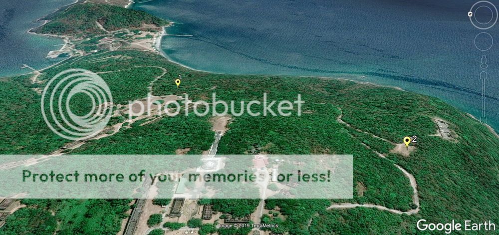 #1 is Battery Ramsay, #2 is Battery Geary 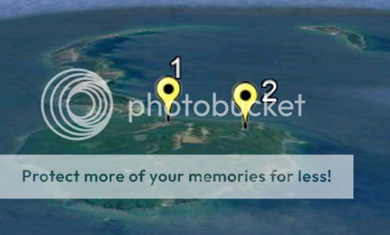
Also, ignore what you hear on the day tour that “Corregidor did not even have a blade of grass on it in 1945”. Other that parts of Topside and Bottomside, Corregidor had lots of trees, especially in the ravines. Note the aerial recon photo dated February 6, 1945. 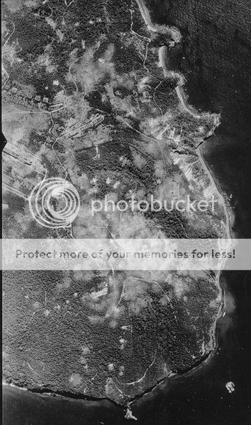 February 6, 1945 photo showing lots of trees on Corregidor. (credit to Dan's collection) #2 Here more Google Earth views. I agree that the explosion seems closer to Battery Wheeler than Battery Cheney. Battery Wheeler itself is intact today so it is not at that location. As a guess, perhaps we are seeing the northern entrance to Wheeler Tunnel being blown up. I really don’t know what such a large explosion in this area was. 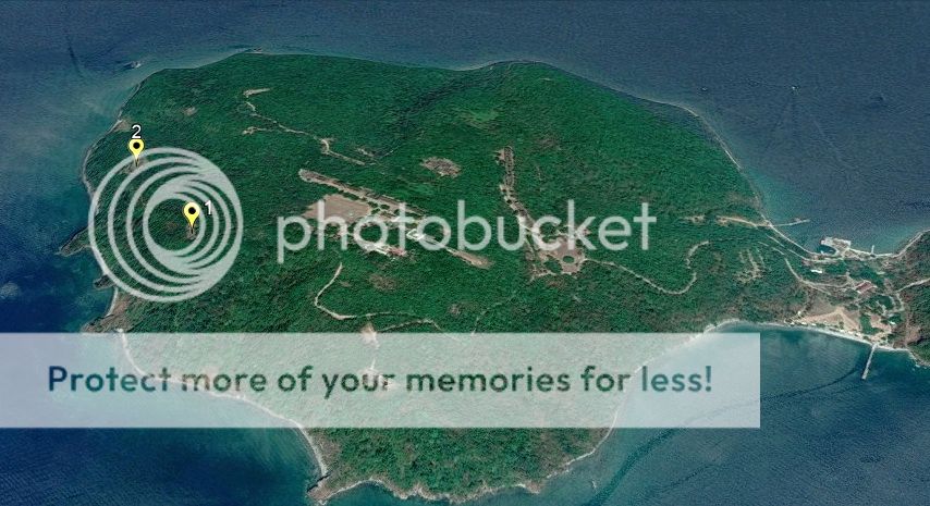 #1 is Battery Wheeler, #2 is Battery Cheney 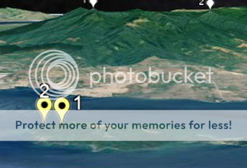 |
|
|
|
Post by fots2 on Jun 8, 2019 12:59:44 GMT 8
Hello Chad, Psssst….did you forget to remove the photo labels?  You have been busy collecting photos. Nice job! 1. My guess is that this is the explosion of the magazine between gun #1 and gun #2 at Battery Ramsay. I have never read the exact date this happened in early 1945 but hopefully someone can answer that for us. 2. I am not sure what this explosion was. It is in the direction of Battery Cheney but that battery is intact. There are many craters in the area but I have no idea what such a large explosion would be. Any ideas? 3. Now this one is easy. (rotate the photo left). This is the 12-inch mortar which was blown inside the left-hand magazine when Battery Geary exploded. It now partially holds up the roof. Another mortar holds up the outer edge of this same roof. A photo of the opposite end of the mortar in your photo is below. 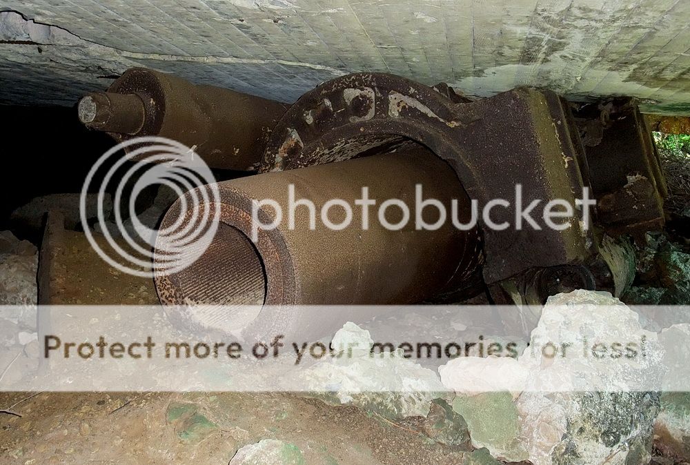 Great photos Chad. Thanks. |
|
|
|
Post by fots2 on Jun 7, 2019 12:50:00 GMT 8
Reply to the third post. 1. The photo of the concrete doorway going underground is shown on maps as Site "B". This doorway is one of two entrances to an underground magazine for one of the four original anti-aircraft guns (dated 1917). The gun block is approximately 15 or so meters from there but difficult to see as it is overgrown. This link will show you photos of the place. Site "B"2. The two level bunkers are battery control stations for mortar batteries Way and Geary. This area can be quite thick and thorny. 3. The "old radio mast" you saw up there was exactly that. It is one of about ten of them that ran in mostly a straight line along the ridge from Radio #2 towards the north shore of the island. FYI, Radio #2 is the structure adjacent to Battery Way. From the mortars, walk towards the toilets, go past them and you will see a concrete staircase down to it. |
|
|
|
Post by fots2 on Jun 7, 2019 12:41:51 GMT 8
Reply to the second post.
This is what the Inn's guides call the "Duck Walk Tunnel" due to the fact you have to bend over in it. The location is between Battery Way and the post hospital close to where the dual trolley line passed by.
This concrete "tunnel" looks impressive but is actually just underground drainage. It is unique due to the graffiti on the walls.
|
|
|
|
Post by fots2 on Jun 7, 2019 12:35:13 GMT 8
Reply to the first post. 1. The road sections labeled in yellow still exist but are all overgrown. Effort would be required to clear the road but it is doable. Starting at Kindley Field and travelling counter-clockwise, the section along the airstrip has small trees, bushes and grasses. Moving towards the hairpin turn at the eastern end of the road you see some larger trees but still lots of bushes and grass. There is a concrete rifle butt (i.e. defensive wall) to the right before the turn. In the area of the turn itself is one of the old cemeteries with some Spanish text on headstones. After the turn there are some larger trees for awhile and the road is covered with high grass. Nearing the airstrip, the trees become smaller and there is mostly large bushes and high thick grasses. Past the airstrip heading west we come to large trees again. Although the road is grassy and has lots of fallen branches etc, the road is often walkable. Along here, the two balloon hangars and Denver Tunnel can be visited. This road rejoins the main road at the Philippine Heroes Memorial. The overall terrain is generally flat and still has culverts as it was a vehicle road. This would be ideal for hiking and bicycles. Two other roads north of the airstrip which intersect the one in question could also be cleared. They take you to interesting locations along the north shore of the island.
2. The south side of Malinta Hill is a huge mass of fractured rock. The South Shore Road could be cleared but you can never guarantee that more rock will not fall at any moment making it a dangerous road to use. 3. The horses were brought to Corregidor and available for rides at the south part of Bottomside. They were never popular and eventually moved to Kindley Field where they actually became a bit wild. They would try to bite people who approached them. Fortunately they were removed from the island. 4. The Spanish cistern is still there beside the lighthouse. It is original as far as I know. That photo is from a book which is labeled below. 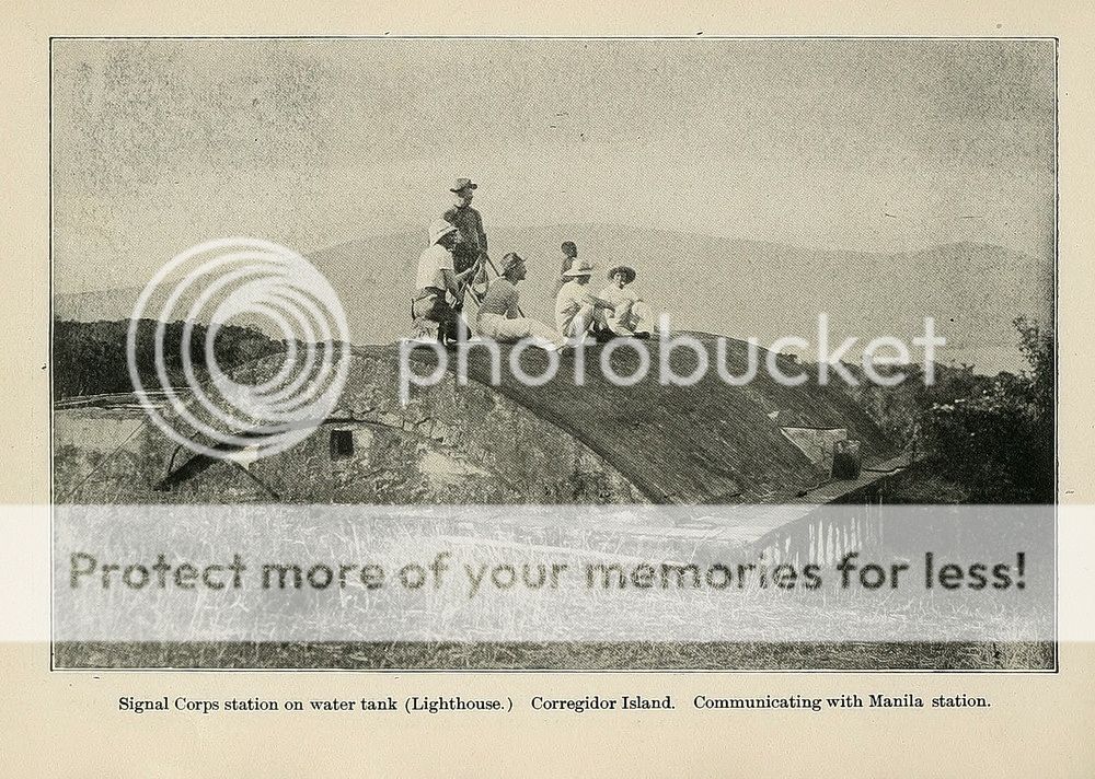 |
|


