|
|
Post by cbuehler on Jun 17, 2019 7:03:19 GMT 8
So hard to believe, I would never have recognized that as the road and Kalaklan ridge, which I was fortunate enough drive by with Karl at the helm some years ago. All of this area, as well as the Cabalan zig zag area, have changed so much and seem have no visible trace of what happened there.
Karl mentioned the ridge as cemetery, but it struck me as a virtual town in itself today, the cemetery virtually covering the ridge.
CB
|
|
|
|
Post by Karl Welteke on Jun 23, 2019 14:06:46 GMT 8
The 38th Div. Yearbook, last three pics, Battle of the Zig-Zag Pass A very good friend of mine, we met on Corregidor several times sent me 1945 pictures and he said this: “Hi Karl, I found this 38th Division (Indiana National Guard) Yearbook at the local Library. I copied about 40 pictures, go ahead, and post them as you wish”. These are the last three pictures. My friend Roger Davis is a very active member of the Coastal Defense Study Group (cdsg.org) and has contributed much in keeping alive the history of the US Army Coastal Defense. All of the pictures were uploaded into this album in high resolution, be our guest if you are interested: www.flickr.com/photos/44567569@N00/albums/72157709117454053 U148. This is one of three images of the 38th Div. in the Battle of the Zig-Zag Pass out of Olongapo. This picture was copied from a 38th Inf. Div Yearbook at a local U.S Library by Roger Davis who is a member of the Coastal Defense Study Group (cdsg.org). This is the cover of the yearbook.  U149. This is one of three images of the 38th Div. in the Battle of the Zig-Zag Pass out of Olongapo. This picture was copied from a 38th Inf. Div Yearbook at a local U.S Library by Roger Davis who is a member of the Coastal Defense Study Group (cdsg.org). The Japanese had tanks and even 120mm mortars.  U150. This is one of three images of the 38th Div. in the Battle of the Zig-Zag Pass out of Olongapo. This picture was copied from a 38th Inf. Div Yearbook at a local U.S Library by Roger Davis who is a member of the Coastal Defense Study Group (cdsg.org). Incredible a whole regiment walked thru the Zambales Mountains and hooked around the Japanese defenses at the Zig-Zag Pass. These Negritos guided them, where is their water canteens? |
|
|
|
Post by Karl Welteke on Dec 24, 2021 21:56:37 GMT 8
PLDT Mountain at Barangay Roosevelt 2021-12-22. A local Subic Bay/Olongapo Hike; PLDT Mountain is the one opposite of the Sta. Rita. Mountain and has all the communication towers on top. At the start of the Battle of the Zig-Zag Pass, east of Olongapo, one regiment of the 38th Div. guided by Aeta men, marched around the PLDT mountain from Olongapo to Dinalupihan to attack the Japanese defenders from the rear. That must have been a hell of a march with all the gear and weapons! I walked this mountain before, a number of years ago. The dry season has started and is time to walk. I parked at the Roosevelt Barangay Hall, only about 50 meters from the start of the road up the mountain. The road up can be walked easy, it got little worse now at places. The new high Voltage Power Line being built caused the trail to go down to Payangan and San Pablo to be a dirt road now and so, it is now easier to walk now. It was a very good day to walk but a very bad day for pictures, a bad haze was hanging over this area. But here are some pictures anyway. I posted 14 images into this Flickr Album, click here: www.flickr.com/photos/44567569@N00/albums/72177720295477049Here is one picture of that album. 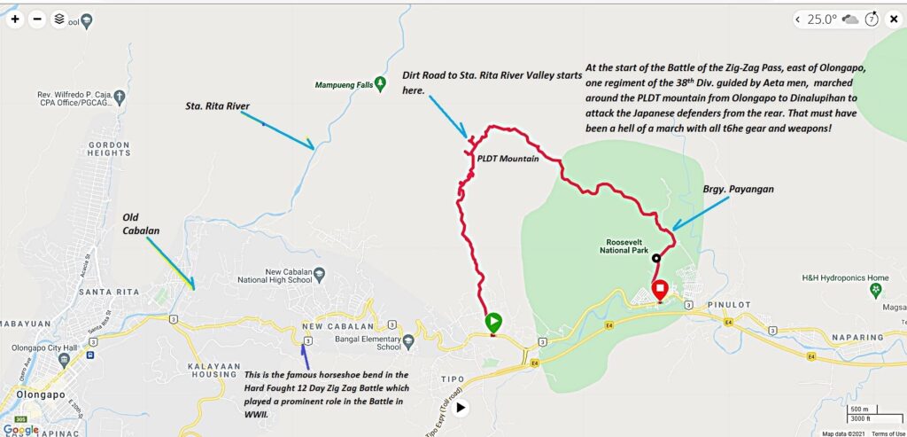 Zf458. - 211222 PLDT Mt. to San Pablo, Garmin, big map. This my Garmin account map with my GPS track going up the PLDT Mountain in Barangay Roosevelt in Bataan. |
|


