


Post by fots2 on Aug 6, 2012 0:08:21 GMT 8
The Fort Bonifacio Tunnel - Part 1
Months ago local news reports about a wartime tunnel in Metro Manila caught my attention. What was this all about? Here is a sample of one of the reports.
“Decades of commercial development had obliterated a big portion of the 2.24-kilometer long war tunnel located underneath Fort Bonifacio in Taguig City and now, the Armed Forces of the Philippines (AFP) wants to reopen it as a heritage site dedicated to the unsung Filipino liberators who fought to their last breath against Japanese invasion during the World War II.
Col. Arnulfo Marcelo Burgos Jr., Army public affairs head and spokesman, said the preservation of the Fort Bonifacio tunnel as a heritage site and its opening for public viewing is the initiative of the Bases Conversion and Development Authority (BCDA) to honor “our unsung heroes who sacrificed their lives in pursuit of our independence.”
Originally, the tunnel had 32 built-in chambers and two passable exits, one leading to Barangay Pembo and the other to Barangay East Rembo, Makati City.
“Today, amid the rapid development of Bonifacio Global City, a 730-meter segment of the tunnel remains unaffected, existing underneath the C-5 Road, with its opening near Market! Market! The tunnel serves as an underground pathway and can be found at the eastern portion of Bonifacio Global City,” Burgos said.
The tunnel used to be the main attraction of the old Philippine Army Museum and Library (PAML), which has since been relocated as a result of the developments made by the BCDA in the area.
“Now that we are bringing it back to life, we will now have a new experience inside the tunnel with the memories of our war heroes. It is also seen as a means to augmenting our tourism industry which has a direct effect in stimulating our country’s economic growth,” Burgos said.
Starting with the Fort Bonifacio tunnel, the AFP and BCDA will be converting to heritage sites all existing war tunnels for public viewing found in other military bases across the country.
BCDA President and CEO Arnel Paciano Casanova said the project aims to contribute to the people’s understanding and appreciation of the history of the former military camps.
Retired Army Maj. Gen. Restituto Aguillar, who is finishing a book of military historical sites in the country, said the old tunnel has rich history.
Aguillar has corrected several misconceptions specifically in its construction period and its laborers.
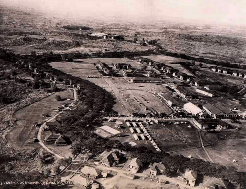
“The tunnel was constructed almost simultaneously with the construction of Fort McKinley [now known as Fort Bonifacio] around 1910 which took almost a decade before being completed. This was prior to General Douglas MacArthur’s reign as the Field Marshal of the Philippine Army, thus debunking the claim that it was MacArthur himself who instructed for the tunnel’s construction,” he said.
He said the tunnel served as the main supply depot of the north and southern operations of the US forces against the Filipino revolutionaries.
“Most of the tunnel’s laborers came from the mining firms in Baguio and Benguet as the others were Japanese laborers who were later discovered as soldiers spying for the Japanese military,” Aguillar said”. (text courtesy of Business Mirror)
Imagine a 2.24km long tunnel complex under a modern city that few people seem to know exists. In the 1990s, a portion of the tunnels were open to the public lying under the original Philippine Army Museum. Since the museum was relocated due to road construction, the tunnels have officially been closed. This YouTube video gives us an idea of what to expect inside them.
I have been informed that the historical details in the News reports are most likely inaccurate but that just peaks my interest even more. Learning about these tunnels has been no easy task as books rarely mention them and when they do, the information is sketchy. Few war related topics in the Philippines have so little known about them.
It would be more accurate to refer to the ‘Fort Bonifacio’ tunnels as the ‘Fort McKinley’ tunnels as it was during this time that they were constructed. (After independence, Fort McKinley was transferred to the Philippines and renamed Fort Bonifacio). The tunnels may have been started in the early 1900s but some sources mention work being done in the early days of WWII.
Here is a look at the only tunnel map that I know to exist. Unfortunately just a portion of the tunnels are drawn. It shows the main entrance, laterals, rooms and three exits. Since the museum is shown, I have a feeling that it was a sketch handed out to visitors who took the tour. US Army blueprints must have existed and may be hidden away in archives. To my knowledge, no one has looked for it.

There is no question that there are more entrances than the two mentioned in the News reports. I know of five and have read about more. Rumors say that a tunnel even runs all the way to Villamor Airbase (Nichols Field) but no one I have spoken to can confirm it. At the airbase, wartime tunnels are known to exist, but again, to what extent?
It seems that the 730 meter section of the tunnel designated to be a heritage site has not been opened to visitors yet. I was interested to see if anything could be viewed now before the whole place was sanitized for the general public including barriers to areas which will be off limits. Since I knew nothing about the tunnels or even the area, I decided to take a first step and go see what I could find.
The following trip report is that first step. In the future, hopefully, more steps will follow.
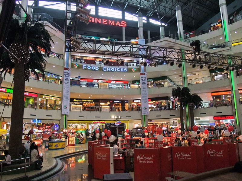
Today, the majority of the old fort has been converted into commercial developments such as offices, malls, condos and restaurants.
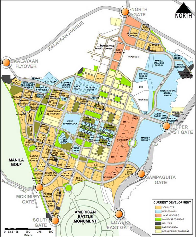
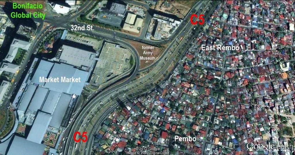
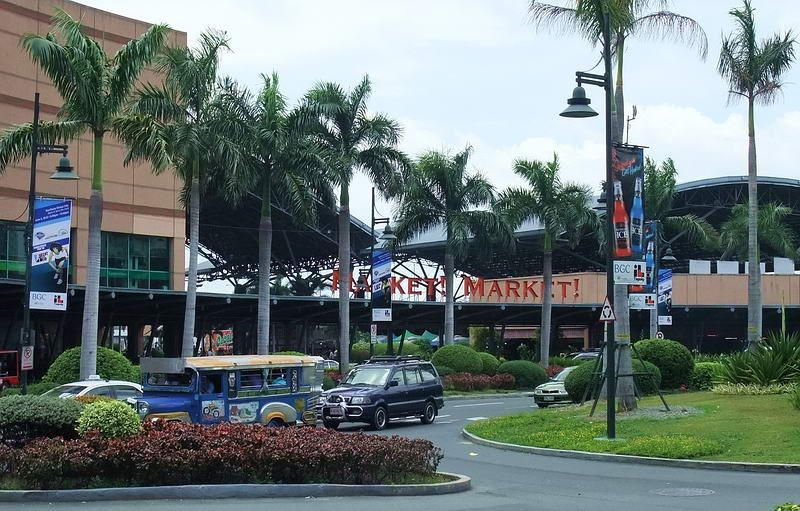
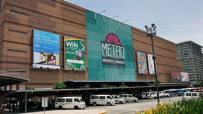
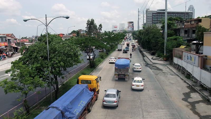
The eastern section of the present day ‘Fort Bonifacio Global City’ has a large property called Market! Market!. This is a mall complex of indoor/outdoor shopping and eating establishments. Adjacent to here are numerous modern buildings with the C5 expressway directly behind it. Across the expressway are civilian barangays which are located outside the perimeter of the former Fort McKinley. If you stand in any one spot near Market Market, you say “no way do any tunnels exist anymore”. It doesn’t even look like there ever was a war here.
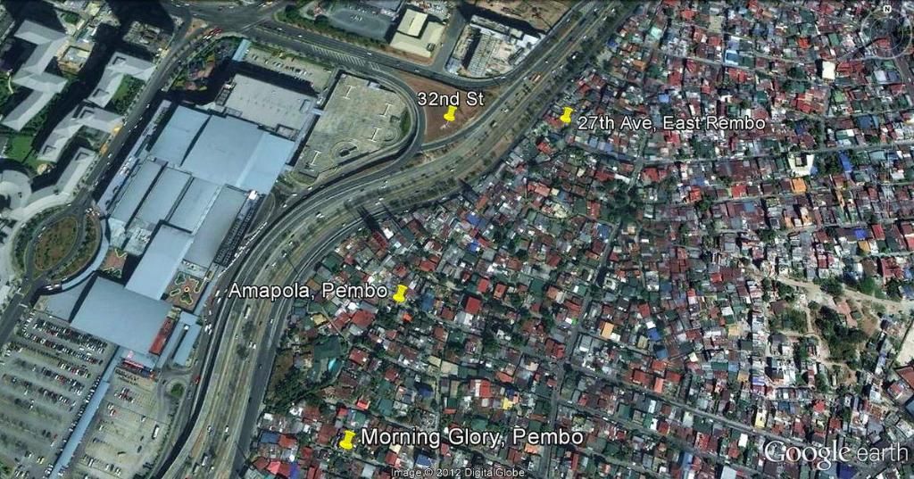
Google Earth satellite photo of the area we will explore today.
The Fort Strip. The Bonifacio Global City Taguig (5 images)
005. The Fort Strip. The Bonifacio Global City Taguig 1st of 5 images from John Moffitt
006. The Fort Strip. The Bonifacio Global City Taguig 2nd of 5 images from John Moffitt
007. The Fort Strip. The Bonifacio Global City Taguig 3rd of 5 images from John Moffitt
008. The Fort Strip. The Bonifacio Global City Taguig 4th of 5 images from John Moffitt

009. The Fort Strip. The Bonifacio Global City Taguig 5th of 5 images from John Moffitt
I found three GPS waypoints recorded by some unknown person to use as a guide. One was for the main entrance beside the former location of the Philippine Army Museum, one was for the East Rembo (27th Ave.) exit and the third was for the Amapola Street exit in Pembo. The Morning Glory exit, also in Pembo, had not been recorded.
On arrival at Market! Market! I proceeded to the intersection of 32nd Street and the C5. One thing immediately obvious was that the Google Earth satellite photo is outdated. It does not show a new Flyover that now connects 32nd Street with the C5 lanes going NE towards the Pasig River. The C5 ‘off’ and ‘on’ ramps and the Flyover appeared to go right over where the old museum was. Prospects for finding this entrance did not look good.

At 32nd Street looking towards the on/off ramps. The main tunnel entrance was straight ahead.
I had no idea how long it would take to find the three exits across the C5 in such densely populated areas so I decided to head over there first and come back later. I had to return home via Market! Market! anyway. Since I was walking I made my way to the edge of the C5 to look for a pedestrian overpass. One looked to be quite a distance away but I was across the C5 in Rembo only 15 minutes later.
On the pedestrian bridge looking at the C5 expressway.
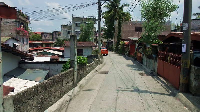
A typical street view in Rembo.
Another street view.
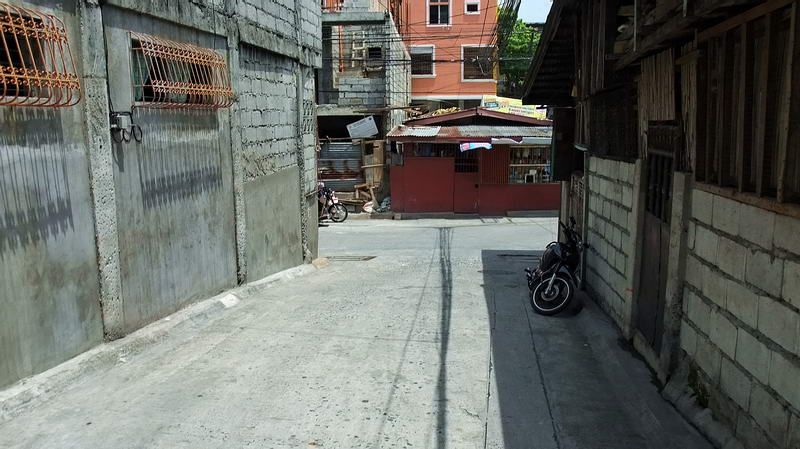
Tunnel entrance #1, East Rembo, was a challenge to find on my own and required some help. It was shown to be located back off of 27th Avenue which was just a solid mass of small concrete houses accessed via narrow alleys and footpaths. Two cars ‘may’ have been able to pass on this avenue.
When I was as close as I could get, I asked a couple teenaged guys if they knew where a tunnel was. One of them walked into an alley and up to a doorway. After explaining what I was after, the owner said “walang problema” and to follow her. We went in the door, the Lola (grandmother) moved her chair away from watching TV, we slid around the kitchen table, out a side door, turned left, then walked straight ahead along a narrow alley between the house and a concrete wall.
A few feet from the rear of the house were three sheets of corrugated metal leaning against a concrete wall. A pile of garbage held up the metal sheets which she pointed to. (This wall looks like it has been cut into the hillside).
After bending a corner of the sheet out of the way, I saw a metal rod door in front of a tunnel. The owner has never been in the tunnel but says it has lots of water in it (plus cobras). I did not ask how she knows that.
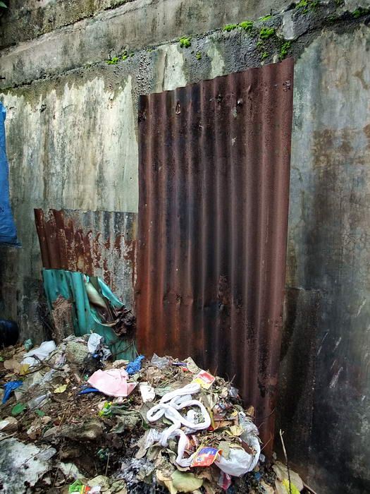
This looks like nothing more than sheets of metal up against a wall.

Bend the sheet and there it is, an entrance to the Fort Bonifacio Tunnels.

Looking down towards the tunnel entrance you can see how densely packed the buildings are. By the way, the hollow block wall on top of the tunnel is another house.
The property owners were quite accommodating so I did not feel right about doing a ‘hit and run’. I stayed to socialize for a few minutes. This proved beneficial for two reasons. First, I am invited back again at any time to see the tunnel and second, one guy knew where the other two entrances were. Not being a complete idiot, I promptly hired the guy for a minimal amount. It could take me forever to find the tunnels on my own. (Two of his buddies tagged along but the tip was already set, all worked out well. Good kids).
Off we went to tunnel #2 which was at Amanpola Street. Six minutes of walking put us on the spot where someone’s waypoint had said the tunnel would be. Nothing was seen here and my guide was scratching his head. We asked around and were told the story that yes, there was a tunnel there but it was completely sealed recently during the construction of the new house we were standing beside.
The new house is almost complete and a workman was laying down a stone pathway. He said that when the house was built into the slope, a hollow block wall was constructed across the tunnel entrance. The tunnel is now behind the bathroom wall at the rear of the house. I got permission to take a photo through a window showing the bathroom door so I could estimate the distance between the tunnel and the waypoint I recorded outside.
This new house has covered up the Amapola Street tunnel entrance forever.
Looking through a window, the washroom door is at the far end of the room. The tunnel entrance is behind a new concrete wall to the left.
I was told that there is one other tunnel across Amanpola Street SW from the new house. Part of a lot is very grown up and there is a small cliff at the back facing the C5. The owner was not home and no one knew any details about it. Although I could not see it through the vegetation, I would estimate it to be 100 feet or more from the new house.
When finished here, we headed towards Tunnel #3 at Morning Glory Street. Using a shortcut, we were at a tunnel entrance within five minutes. As we walked up to the end of the street there was a long set of steps going up to the edge of the C5. At the base of the steps on the right was an open tunnel.
The ceiling was dripping and the silty floor was quite soft and spongy. I only went in about 10 feet from the entrance. Garbage is scattered around and has the look of having been carried there by rain water. Actually, this looks more like a drainage tunnel but perhaps some hurried tunnel construction was unlined or simply unfinished before work was stopped. The tunnel is about 8 feet wide but now only a little over 3 feet high. I have no idea how deep the silt is so I cannot say if this ever was a full size tunnel. They assured me that this was Morning Glory Street and my GPS agreed with them.

The open tunnel entrance is straight ahead. The right side steps take you up to a road beside the C5 expressway.
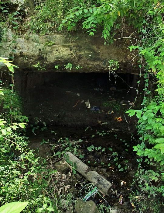
Closer view of the tunnel entrance.

Inside the tunnel entrance.
I asked about other tunnels nearby and they knew of none. The guide then mentioned an entrance across the C5 beside Market! Market!. That got my attention! Does it still exist? He said yes so off we went again. After the near death experience of directly crossing six lanes of busy C5, we were soon back at 32nd Street.
Looking towards the location of the former museum, you see three roads. The C5 ‘on’ ramp, the C5 ‘off’ ramp and the newer Flyover. Crossing over two of them then walking towards the C5 puts you at a split between roads. Located here is a little depression just above the embankment down to the C5. There it was, a flat concrete platform with steel plates on one side. The three guys managed to lift the heavy plate long enough for me to get a photo of the steps leading down. This was the main entrance at the back of the old Philippine Army Museum.
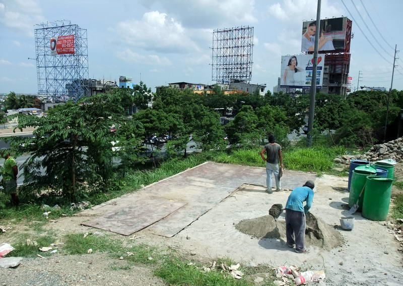
Above the embankment down to the C5 expressway is this concrete pad with ¼ inch steel slates on top of it.

My three guides earning their keep. The plate was heavy but they lifted it up.
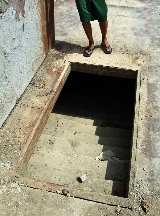
A view of the main Fort Bonifacio Tunnel (32nd Street) entrance.
A Google Earth satellite photo showing the four tunnel entrances identified today.
Since no major construction is going on here then it is obvious that these tunnels will not be opened up to the public anytime soon. At least now I know that they still exist and where to find them. I have an idea for a second step. If anything comes of it I will keep you informed.
Months ago local news reports about a wartime tunnel in Metro Manila caught my attention. What was this all about? Here is a sample of one of the reports.
“Decades of commercial development had obliterated a big portion of the 2.24-kilometer long war tunnel located underneath Fort Bonifacio in Taguig City and now, the Armed Forces of the Philippines (AFP) wants to reopen it as a heritage site dedicated to the unsung Filipino liberators who fought to their last breath against Japanese invasion during the World War II.
Col. Arnulfo Marcelo Burgos Jr., Army public affairs head and spokesman, said the preservation of the Fort Bonifacio tunnel as a heritage site and its opening for public viewing is the initiative of the Bases Conversion and Development Authority (BCDA) to honor “our unsung heroes who sacrificed their lives in pursuit of our independence.”
Originally, the tunnel had 32 built-in chambers and two passable exits, one leading to Barangay Pembo and the other to Barangay East Rembo, Makati City.
“Today, amid the rapid development of Bonifacio Global City, a 730-meter segment of the tunnel remains unaffected, existing underneath the C-5 Road, with its opening near Market! Market! The tunnel serves as an underground pathway and can be found at the eastern portion of Bonifacio Global City,” Burgos said.
The tunnel used to be the main attraction of the old Philippine Army Museum and Library (PAML), which has since been relocated as a result of the developments made by the BCDA in the area.
“Now that we are bringing it back to life, we will now have a new experience inside the tunnel with the memories of our war heroes. It is also seen as a means to augmenting our tourism industry which has a direct effect in stimulating our country’s economic growth,” Burgos said.
Starting with the Fort Bonifacio tunnel, the AFP and BCDA will be converting to heritage sites all existing war tunnels for public viewing found in other military bases across the country.
BCDA President and CEO Arnel Paciano Casanova said the project aims to contribute to the people’s understanding and appreciation of the history of the former military camps.
Retired Army Maj. Gen. Restituto Aguillar, who is finishing a book of military historical sites in the country, said the old tunnel has rich history.
Aguillar has corrected several misconceptions specifically in its construction period and its laborers.
“The tunnel was constructed almost simultaneously with the construction of Fort McKinley [now known as Fort Bonifacio] around 1910 which took almost a decade before being completed. This was prior to General Douglas MacArthur’s reign as the Field Marshal of the Philippine Army, thus debunking the claim that it was MacArthur himself who instructed for the tunnel’s construction,” he said.
He said the tunnel served as the main supply depot of the north and southern operations of the US forces against the Filipino revolutionaries.
“Most of the tunnel’s laborers came from the mining firms in Baguio and Benguet as the others were Japanese laborers who were later discovered as soldiers spying for the Japanese military,” Aguillar said”. (text courtesy of Business Mirror)
Imagine a 2.24km long tunnel complex under a modern city that few people seem to know exists. In the 1990s, a portion of the tunnels were open to the public lying under the original Philippine Army Museum. Since the museum was relocated due to road construction, the tunnels have officially been closed. This YouTube video gives us an idea of what to expect inside them.
I have been informed that the historical details in the News reports are most likely inaccurate but that just peaks my interest even more. Learning about these tunnels has been no easy task as books rarely mention them and when they do, the information is sketchy. Few war related topics in the Philippines have so little known about them.
It would be more accurate to refer to the ‘Fort Bonifacio’ tunnels as the ‘Fort McKinley’ tunnels as it was during this time that they were constructed. (After independence, Fort McKinley was transferred to the Philippines and renamed Fort Bonifacio). The tunnels may have been started in the early 1900s but some sources mention work being done in the early days of WWII.
Here is a look at the only tunnel map that I know to exist. Unfortunately just a portion of the tunnels are drawn. It shows the main entrance, laterals, rooms and three exits. Since the museum is shown, I have a feeling that it was a sketch handed out to visitors who took the tour. US Army blueprints must have existed and may be hidden away in archives. To my knowledge, no one has looked for it.
There is no question that there are more entrances than the two mentioned in the News reports. I know of five and have read about more. Rumors say that a tunnel even runs all the way to Villamor Airbase (Nichols Field) but no one I have spoken to can confirm it. At the airbase, wartime tunnels are known to exist, but again, to what extent?
It seems that the 730 meter section of the tunnel designated to be a heritage site has not been opened to visitors yet. I was interested to see if anything could be viewed now before the whole place was sanitized for the general public including barriers to areas which will be off limits. Since I knew nothing about the tunnels or even the area, I decided to take a first step and go see what I could find.
The following trip report is that first step. In the future, hopefully, more steps will follow.
Today, the majority of the old fort has been converted into commercial developments such as offices, malls, condos and restaurants.
The eastern section of the present day ‘Fort Bonifacio Global City’ has a large property called Market! Market!. This is a mall complex of indoor/outdoor shopping and eating establishments. Adjacent to here are numerous modern buildings with the C5 expressway directly behind it. Across the expressway are civilian barangays which are located outside the perimeter of the former Fort McKinley. If you stand in any one spot near Market Market, you say “no way do any tunnels exist anymore”. It doesn’t even look like there ever was a war here.
Google Earth satellite photo of the area we will explore today.
The Fort Strip. The Bonifacio Global City Taguig (5 images)
005. The Fort Strip. The Bonifacio Global City Taguig 1st of 5 images from John Moffitt
006. The Fort Strip. The Bonifacio Global City Taguig 2nd of 5 images from John Moffitt
007. The Fort Strip. The Bonifacio Global City Taguig 3rd of 5 images from John Moffitt
008. The Fort Strip. The Bonifacio Global City Taguig 4th of 5 images from John Moffitt
009. The Fort Strip. The Bonifacio Global City Taguig 5th of 5 images from John Moffitt
I found three GPS waypoints recorded by some unknown person to use as a guide. One was for the main entrance beside the former location of the Philippine Army Museum, one was for the East Rembo (27th Ave.) exit and the third was for the Amapola Street exit in Pembo. The Morning Glory exit, also in Pembo, had not been recorded.
On arrival at Market! Market! I proceeded to the intersection of 32nd Street and the C5. One thing immediately obvious was that the Google Earth satellite photo is outdated. It does not show a new Flyover that now connects 32nd Street with the C5 lanes going NE towards the Pasig River. The C5 ‘off’ and ‘on’ ramps and the Flyover appeared to go right over where the old museum was. Prospects for finding this entrance did not look good.
At 32nd Street looking towards the on/off ramps. The main tunnel entrance was straight ahead.
I had no idea how long it would take to find the three exits across the C5 in such densely populated areas so I decided to head over there first and come back later. I had to return home via Market! Market! anyway. Since I was walking I made my way to the edge of the C5 to look for a pedestrian overpass. One looked to be quite a distance away but I was across the C5 in Rembo only 15 minutes later.
On the pedestrian bridge looking at the C5 expressway.
A typical street view in Rembo.
Another street view.
Tunnel entrance #1, East Rembo, was a challenge to find on my own and required some help. It was shown to be located back off of 27th Avenue which was just a solid mass of small concrete houses accessed via narrow alleys and footpaths. Two cars ‘may’ have been able to pass on this avenue.
When I was as close as I could get, I asked a couple teenaged guys if they knew where a tunnel was. One of them walked into an alley and up to a doorway. After explaining what I was after, the owner said “walang problema” and to follow her. We went in the door, the Lola (grandmother) moved her chair away from watching TV, we slid around the kitchen table, out a side door, turned left, then walked straight ahead along a narrow alley between the house and a concrete wall.
A few feet from the rear of the house were three sheets of corrugated metal leaning against a concrete wall. A pile of garbage held up the metal sheets which she pointed to. (This wall looks like it has been cut into the hillside).
After bending a corner of the sheet out of the way, I saw a metal rod door in front of a tunnel. The owner has never been in the tunnel but says it has lots of water in it (plus cobras). I did not ask how she knows that.
This looks like nothing more than sheets of metal up against a wall.
Bend the sheet and there it is, an entrance to the Fort Bonifacio Tunnels.
Looking down towards the tunnel entrance you can see how densely packed the buildings are. By the way, the hollow block wall on top of the tunnel is another house.
The property owners were quite accommodating so I did not feel right about doing a ‘hit and run’. I stayed to socialize for a few minutes. This proved beneficial for two reasons. First, I am invited back again at any time to see the tunnel and second, one guy knew where the other two entrances were. Not being a complete idiot, I promptly hired the guy for a minimal amount. It could take me forever to find the tunnels on my own. (Two of his buddies tagged along but the tip was already set, all worked out well. Good kids).
Off we went to tunnel #2 which was at Amanpola Street. Six minutes of walking put us on the spot where someone’s waypoint had said the tunnel would be. Nothing was seen here and my guide was scratching his head. We asked around and were told the story that yes, there was a tunnel there but it was completely sealed recently during the construction of the new house we were standing beside.
The new house is almost complete and a workman was laying down a stone pathway. He said that when the house was built into the slope, a hollow block wall was constructed across the tunnel entrance. The tunnel is now behind the bathroom wall at the rear of the house. I got permission to take a photo through a window showing the bathroom door so I could estimate the distance between the tunnel and the waypoint I recorded outside.
This new house has covered up the Amapola Street tunnel entrance forever.
Looking through a window, the washroom door is at the far end of the room. The tunnel entrance is behind a new concrete wall to the left.
I was told that there is one other tunnel across Amanpola Street SW from the new house. Part of a lot is very grown up and there is a small cliff at the back facing the C5. The owner was not home and no one knew any details about it. Although I could not see it through the vegetation, I would estimate it to be 100 feet or more from the new house.
When finished here, we headed towards Tunnel #3 at Morning Glory Street. Using a shortcut, we were at a tunnel entrance within five minutes. As we walked up to the end of the street there was a long set of steps going up to the edge of the C5. At the base of the steps on the right was an open tunnel.
The ceiling was dripping and the silty floor was quite soft and spongy. I only went in about 10 feet from the entrance. Garbage is scattered around and has the look of having been carried there by rain water. Actually, this looks more like a drainage tunnel but perhaps some hurried tunnel construction was unlined or simply unfinished before work was stopped. The tunnel is about 8 feet wide but now only a little over 3 feet high. I have no idea how deep the silt is so I cannot say if this ever was a full size tunnel. They assured me that this was Morning Glory Street and my GPS agreed with them.
The open tunnel entrance is straight ahead. The right side steps take you up to a road beside the C5 expressway.
Closer view of the tunnel entrance.
Inside the tunnel entrance.
I asked about other tunnels nearby and they knew of none. The guide then mentioned an entrance across the C5 beside Market! Market!. That got my attention! Does it still exist? He said yes so off we went again. After the near death experience of directly crossing six lanes of busy C5, we were soon back at 32nd Street.
Looking towards the location of the former museum, you see three roads. The C5 ‘on’ ramp, the C5 ‘off’ ramp and the newer Flyover. Crossing over two of them then walking towards the C5 puts you at a split between roads. Located here is a little depression just above the embankment down to the C5. There it was, a flat concrete platform with steel plates on one side. The three guys managed to lift the heavy plate long enough for me to get a photo of the steps leading down. This was the main entrance at the back of the old Philippine Army Museum.
Above the embankment down to the C5 expressway is this concrete pad with ¼ inch steel slates on top of it.
My three guides earning their keep. The plate was heavy but they lifted it up.
A view of the main Fort Bonifacio Tunnel (32nd Street) entrance.
A Google Earth satellite photo showing the four tunnel entrances identified today.
Since no major construction is going on here then it is obvious that these tunnels will not be opened up to the public anytime soon. At least now I know that they still exist and where to find them. I have an idea for a second step. If anything comes of it I will keep you informed.


 ? If so, we have a view of said installation prior to official opening. Those buildings at the bottom of the pic do seem to be unfinished. Just another uneducated guess on my part, but I was curious as to the date. Good view of the place.


