|
|
Post by The Phantom on Jan 14, 2014 7:20:42 GMT 8
U.S. locations of previously mentioned Harbor Entrance Control Posts U.S and abroad.Other HECP Locations
Many HECPs were established at critical harbors on the Atlantic and Pacific coasts of the United States and it's territories:
District # ---- Station ----- Location ----------- Latitude - Longitude
1 -- Portland, ME -- Fort Williams -- (N43-37-15, W70-13-00)
1 -- Portsmouth, NH -- Ex-Coast Guard Station (Fort Stark, Battery Kirk) -- (N43-02-30, W 70-42-00)
1 -- Boston, MA -- Fort Dawes -- (N42-21-30, W57-30)
1 -- Newport, RI -- Beavertail -- (N41-27-00, W71-24-00)
3 -- Fishers Island -- Fort HG Wright -- (N41-15-22.8, W72-01-23.9)
3 -- Staten Island, NY -- Fort Wadsworth -- (N40-36-15, W74-03-22)
4 -- Delaware -- Cape Henlopen (Fort Miles) -- (N38-47-39, W75-05-32)
5 -- Norfolk, VA -- Just outside Fort Story -- (N36-55-48, W76-00-42)
6 -- Charleston, SC -- Fort Moultrie -- (N32-45-33, W79-51-31)
7 -- Key West, FL -- To be established
8 -- Santa Rosa Island, FL -- (Fort Pickens, Battery Worth) -- (N30-19-30, W87-17- 30)
8 -- Galveston, TX -- Fort Point (Fort San Jacinto) -- (N29-20-00, W94-44-37)
10 -- San Juan, PR -- (Fort Brooke, El Morro) -- (N18-28, W66-07)
10 -- Vieques Sound (Roosevelt Roads), PR -- Punta Algodones
11 -- San Diego, CA -- (N32-40-19, W117-14-24)
11 -- San Pedro, CA -- Fort MacArthur (Battery Leary and Merriam) (N33-42-42, W118-17- 32)
12 -- San Francisco, CA -- Fort Winfield Scott (Dynamite Battery) -- (N37-48-08.3, W122-28- 32.7)
13 -- Columbia River -- Fort Stevens (Battery Mishler) -- (To be established)
13 -- Puget Sound Area, WA -- Fort Worden -- (N48-08-30, W122-46-00)
14 -- Pearl Harbor, HI -- NavyYard Pearl Harbor -- (N21-21-11.9, W157-57-26.2)
15 -- Cristobal, Panama Canal Zone (Atlantic Side) -- Fort Sherman -- (N9-22-00, W79-57-00)
15 -- Balboa, Panama Canal Zone (Pacific Side) -- Fort Amador -- (N8-55-00, W7931-00)
16 -- Manila Bay, Corregidor -- Fort Mills -- (N14-22-59, E120-34-23)
|
|
|
|
Post by The Phantom on Jan 14, 2014 7:47:26 GMT 8
The preceding information tells more about H.E.C.P,'s in general than anything I have read about Manila Bay', and Subic Bays,
in particular.
One must Extrapolate the info to some extent knowing that most facilities on Corregidor or in the Bays defenses, were no longer being updated pr-war to keep up with U.S. standards.
If the folks on Corregidor found those huge objects buried for all these years, one has to believe as Fots states that the objects, and who knows what else, is still buried behind the Casement building in Engineers ravine. Buried in the Japanese bombing, and then the shelling from Bataan in 1942.
The casement building is visible from Bataan, the northern corner of this well constructed building has a massive hole today.
The casement building has thick steel blast covered windows facing the cliff face, (and 3 other sides with large blast doors, missing today, in the front of the building), the hillside/cliff above the casement building is steep which must have collapsed as the dirt is still piled up against the back of the building.
If you examine the building style and other similar construction on Corregidor, there will be a concrete or stone wall somewhere buried behind that building to keep the area open so the huge windows, when open, could circulate the air for the generators within and to have had access to breezes blowing from the North Channel.
It's location condemned the building, but it's function had already been moved into the massive underground building to it's north.
Worth another visit, one of the most historic building left on Bottomside.
|
|
|
|
Post by fireball on Jan 14, 2014 12:44:19 GMT 8
|
|
|
|
Post by fots2 on Jan 14, 2014 16:43:14 GMT 8
Fireball, that guy has an interesting back yard. Phantom mentions a structure that some people my be unfamiliar with. Here are a few photos of the Instrument Storehouse/Mine Casemate on Bottomside north. The objects were found in the hillside behind and to the right of it. 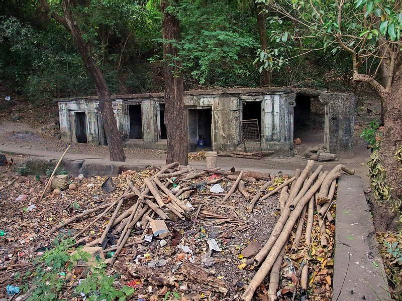 The Instrument Storehouse/Mine Casemate. The western hillside can be seen behind it. Part of a cable tank is in the foreground. 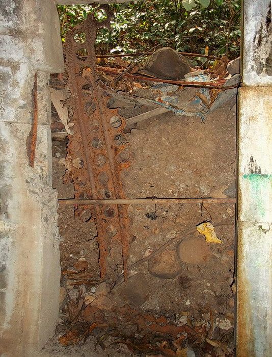 The inside view of a rear window shows that soil has piled up behind the building. 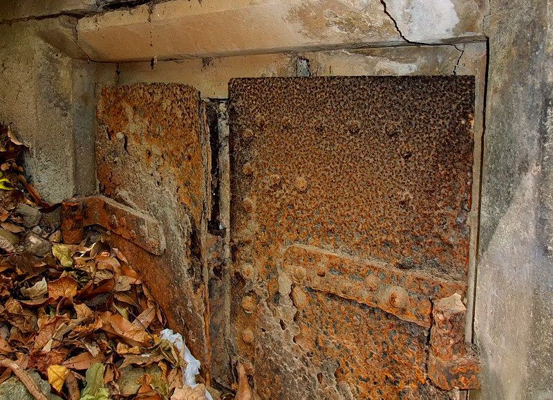 View of soil half way up a side window. 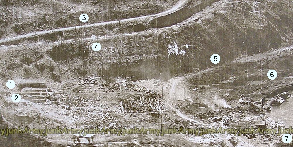 Aerial photo from 1945. (courtesy of Armyjunk) Legend:
1 - Instrument Storehouse/Mine Casemate 2 - Cable Tanks for anti-ship mine cables. 3 - road to Middleside 4 - Bottomside to Middleside dual trolley line 5 - road to Engineer Ravine 6 - Coal Basin 7 - North Dock |
|
|
|
Post by armyjunk786 on Jan 15, 2014 2:09:19 GMT 8
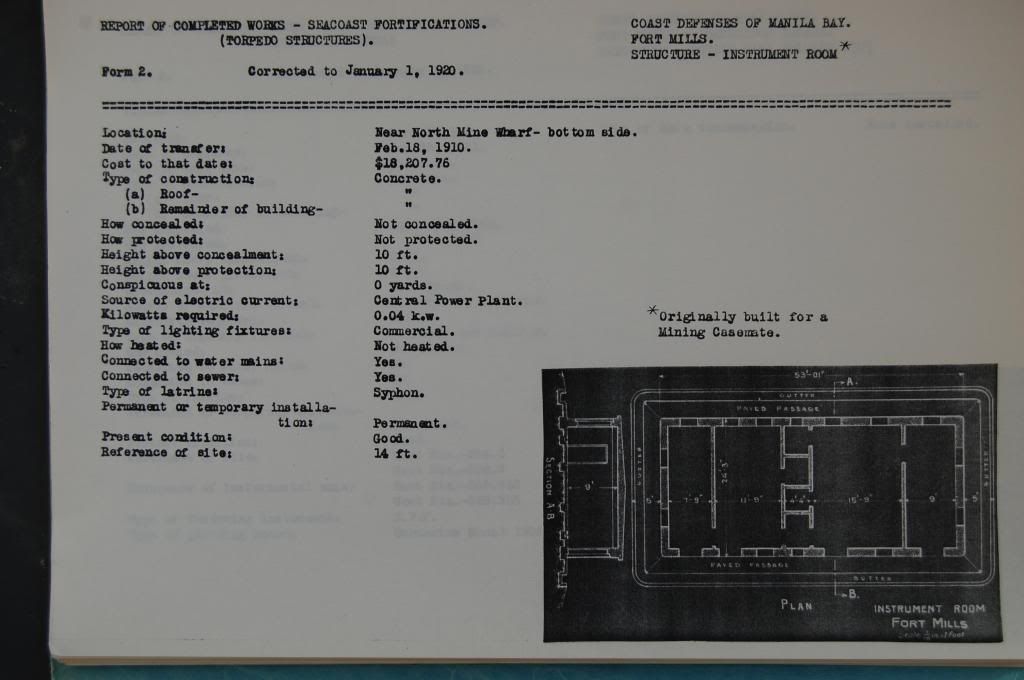 here's the RCW for that Building, in 1920 it called an Instrument Room origially built for a Mining Casemate with no electrical power of its own, getting power from the CPP... |
|
|
|
Post by fots2 on Jan 15, 2014 6:21:14 GMT 8
Armyjunk,
Thanks for posting the RCW. I notice the structure is named “Instrument Room” where the 1936 map labels it as “Instrument Storehouse Casemate”. No big deal I guess but I think I will believe the RCW since that document was created by the people who built the structure.
|
|
|
|
Post by The Phantom on Jan 16, 2014 7:19:43 GMT 8
Thanks for the pictures Fots.
They tell the story.
The very rusted piece of Marsden matting,steel plating used for airfield construction ) seems to have been in place holding the dirt out of the Casement building for some number of years.
(The dirt and debris seem to have solidified almost into part of the wall, after all these years.)
One wonders how and why the Marsden matting made it to Corregidor in the first place.
The Armyjunk photo from 1945 clearly shows the cratered hillside behind-west of the Casement building that provided the fill seen behind the building today--- that covered the bell shaped contraptions and who knows what else.
Whatever they were, they must have been unnecessary to those doing battle on Corregidor in 1942.
Armyjunk's construction document adds to this untold story of a Bottomside building buried out of site of most on Corregidor, but the workmen who live immediately next door.
Several concrete cable tanks are still visible just east of this casement building.
Damaged and overgrown with vines etc. and some Corregidor fodder...........
* Note by exo - as obtained from Wikipedia - Marsden Matting is standardized, perforated steel matting material originally developed by the United States at the Waterways Experiment Station shortly before World War II, primarily for the rapid construction of temporary runways and landing strips. The material is also commonly known as Marston mats (or Marston Plate) for a town in North Carolina adjacent to Camp Mackall airfield where the material was first manufactured and used in November 1941. The material was also used in the Korean and Vietnam Wars where its common name, from its NATO Stock Number nomenclature, is pierced (or perforated) steel planking (PSP).
|
|
|
|
Post by armyjunk68 on Jan 17, 2014 1:01:37 GMT 8
matting quite possible used on beaches for better traction over sand once the initial landing took place. a guess, a deuce and a half can tear up a beach
|
|
|
|
Post by beirutvet on Sept 17, 2014 22:40:57 GMT 8
Could the Marsdon Matting also have come from the fabled, yet still undiscovered temporary airfield on topside? possible connection to two Corregidor mysteries
|
|
|
|
Post by EXO on Sept 18, 2014 18:04:23 GMT 8
The aircraft which made the landings on topside were L-4's (the Piper Cub) and there's no indication that the strip was any more elaborately prepared than just by filling in the bomb or artillery craters and clearing away debris.
|
|


