|
|
Post by Karl Welteke on Jul 22, 2008 12:26:33 GMT 8
More on the area west of the US Military Reservation Boundary marker and the Death March Marker # 112. Y436- Section of a 1:50000 map showing the area of Capas to the Capas Memorial Shrine dedicated to the about 30,000 soldiers who died in the hands of Japan. 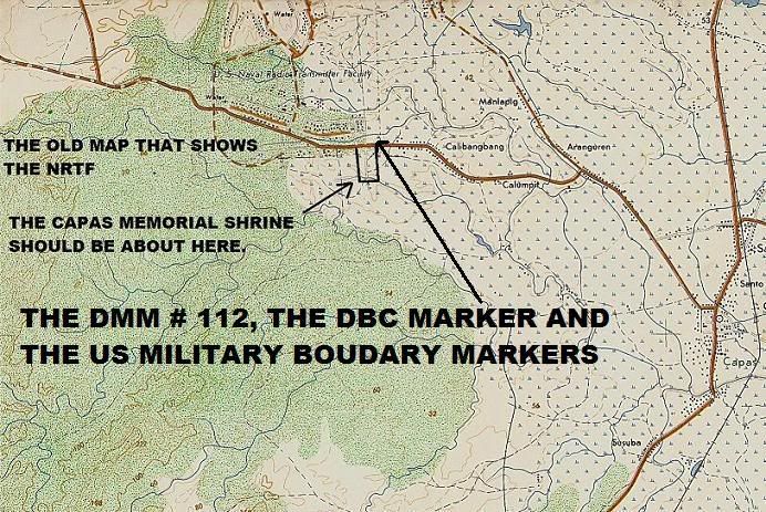 Y437- A Google Earth image of the Capas Memorial Shrine near Capas, Tarlac, R.P: 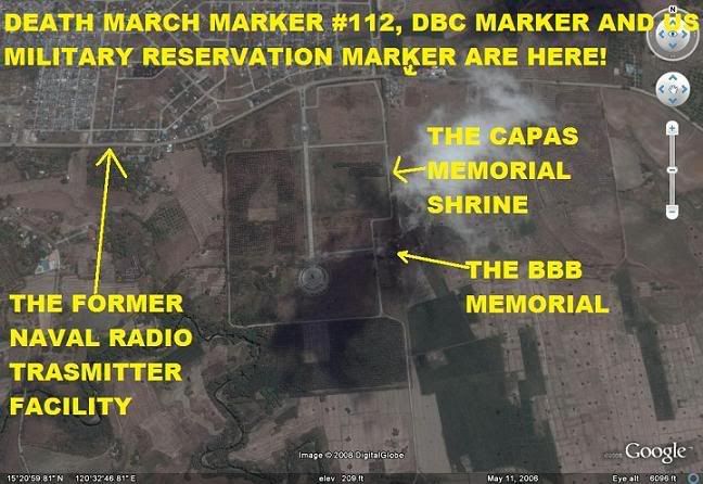 The Commander/Adjutant of the Battling Bastards of Bataan wrote this about the area here. Karl You must remember this though. The American side of O'Donnell was on the other side of the road. Our BBB Memorial, the PA Memorial, the PS Plaque, the entire Capas Shrine are on the side where the Filipino Troops were held. To my knowledge, the last time I was there, there is nothing on the American Troop side except memories of hell. As I understand it, that side was used when they had to find a place to relocate people when Mt. Pintatubo exploded. There about 9,400 American Troops on this side and about 54,000 Filipino Troops across the Road where all the Memorials are now. As I recall, quite some distance further down the road, there was the PA Camp. We went there but they would not let us in. But, our part of Camp O'Donnell was as noted above, closer to where the U, S. had an AC&W Site at one time. In fact it was Airmen assigned to this site that found our Cement Cross that Richard Gordon and Phil Coon helped build from the sacks of cement the Japanese gave us INSTEAD OF FOOD - TO IMPROVE OUR MORALE!!!!!!!! This Cross now rest as a Center Piece in the POW National Museum at Andersonville, GA. Tillman J. Rutledge Commander/Adjutant Battling Bastards of Bataan |
|
|
|
Post by Karl Welteke on Jan 20, 2014 19:05:13 GMT 8
UPDATE ON THE US MILITARY BOUNDARY MARKER AT CAPAS WHO SPEAKS A LITTLE SPANISH? Someone or an unknown activity cleaned up and repainted this very unique historical marker. One can read it now, it clearly says “Se Prohibe El Paso” and “ Bawal Magdaan”. In two previous segments I just now posted 5 pictures instead of just having the URLs for the pictures there. I think I learned in my research that the words “Camp O’Donnell” in recent post war history referred to the area and camp that is now being used by the Philippine Army as described by Ramon Ong in his 20th July 2008 entry. It seems before the Philippine Army took over that area it was home of US AIR Force units and was called Camp O’Donnell. To confuse matters further, people heading in that direction look for or can be heading to Barangay O’Donnell, the O’Donnell River, the Crow Valley Bombing Range located on the O’Donnell River and then most people going to visit Mt. Pinatubo go via this O’Donnell River route. In the 1940s, the area where the Death March ended, where all the American and Philippine POWs were kept, is the area very much next to this boundary marker and that was called Camp O’Donnell then. The Filipino Soldiers were kept south of the road and part of that camp has become the Capas National Shrine. The Americans were kept north of the road and that area became later the Naval Radio Transmitting Facility, Capas. After the US Military left the Philippines, this area, the American POW section of this Camp O’Donnell became a resettlement area for people that were displaced by the Mt. Pinatubo Eruption. I established an album about this marker and this is the URL for it with 29 images: app.photobucket.com/u/PI-Sailor/a/5d829075-5ff0-4e8e-b9b9-50ed56c9e13dHere are 3 sample images: 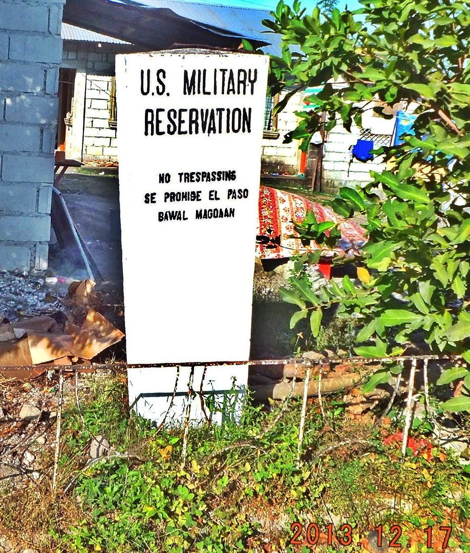 Y422- 2013-12-17 On this date we found the US Military Reservation Boundary marker all cleaned up and repainted and now we can clearly read what it says. In the past this marker was almost in a unreadable state. 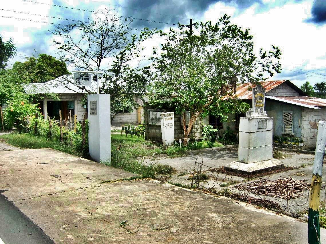 Y418- 2008-01-17 This is how the Memorial, Marker looked in 2008 and it is the way it looked in 2013, the two times I had a closer look. All three Memorial Markers can be seen. Houses are all around it now. 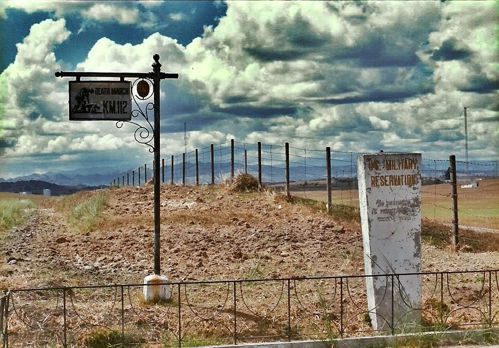 Y421- 1986 to 88 time frame, I’m so glad that Chad Hill is sharing this image with us. What a change, wow!!! In 1991 Mt. Pinatubo happened, that is also about the time the US Navy gave up this area it used as a Radio Transmitting Facility and this very place was the very infamous Camp O’Donnell, the American Prisoner of War side. |
|
|
|
Post by Karl Welteke on Jan 27, 2016 20:47:27 GMT 8
THERE ARE MORE US MILITARY BOUNDARY MARKERS LEFT IN THE PHILIPPINES 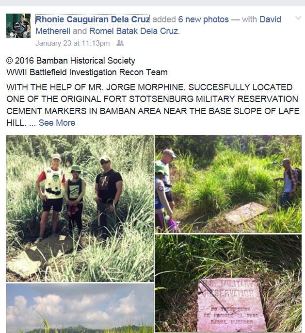 W604 Rhonie Cauguiran Dela Cruz added 6 new pictures in his Facebook page on 23rd Jan. 2016. This is the URL: Here are a few sample images: 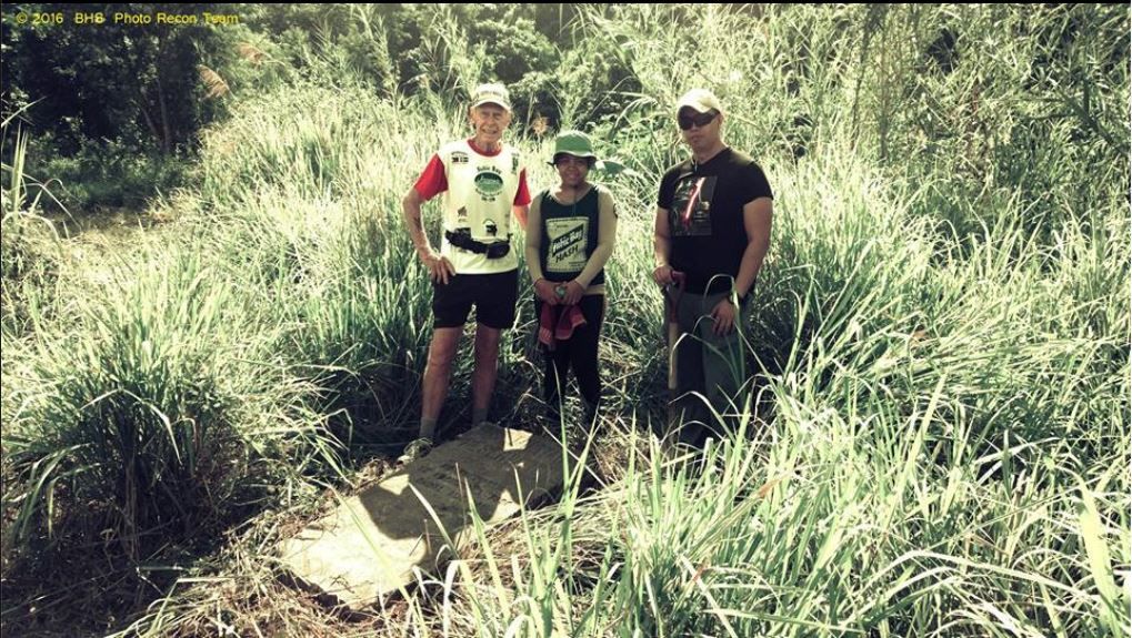 W605 the search and recovery team of the old US Military Boundary Marker in the former Clark Air Field area from the Bamban Historical Society (BHS) Bamban Museum of History. 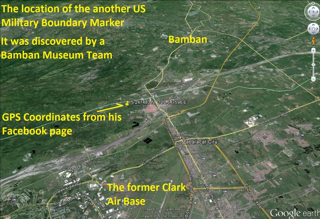 W606 the coordinates of the old US Military Boundary Marker in the former Clark Air Field area. It was provided in the above URL. 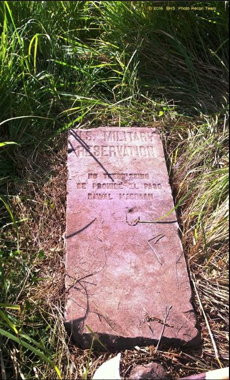 W607 the other, the 2nd one, of the old US Military Boundary Markers. It was found by the search and recovery team from the Bamban Historical Society (BHS) Bamban Museum of History. I say 2nd because as we point out in this thread the 1st one is next to the Death March Marker #112. 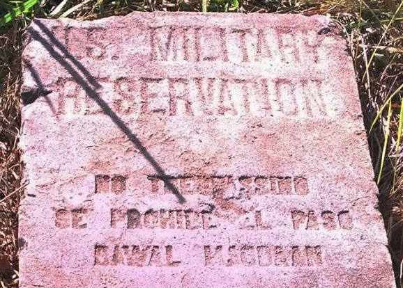 W608 a close-up image of the last picture # W607. The engraved writing is still in perfect shape after perhaps 100 years when it was placed here. Rhonie Cauguiran Dela Cruz is a most extra ordinary resident of the Municipality of Bamban and has this Facebook page: www.facebook.com/rhonie.d.cruzRhonie Cauguiran Dela Cruz is the leader of the Bamban Historical Society (BHS) and its Bamban Museum of History; where local history comes alive. This is the URL for the Museum: museumofhistory.blogspot.com/2008/09/bhs-bamban-museum-of-history-where.html |
|
|
|
Post by cbuehler on Jan 28, 2016 1:17:12 GMT 8
Fantastic! I dont know what they have planned for this recently discovered marker, but I might suggest that they retrieve the original before it disappears to put in the museum and replace it with an exact replica to be left on the original spot.
CB
|
|
|
|
Post by Karl Welteke on Jul 17, 2022 13:11:49 GMT 8
4 more pictures from the Mil. Boundary Marker area. First a question to the Bamban Museum of History: “What happen to the Marker in Bamban”  ?? 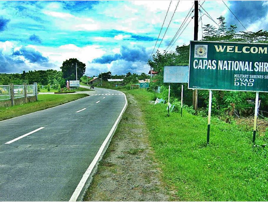 Zf702. 2008-01-17 only a few hundred feet further from the US Military Reservation Marker and the Philippine Defenders of Bataan and Corregidor Memorial Marker is the entrance to the Capas National Shrine. 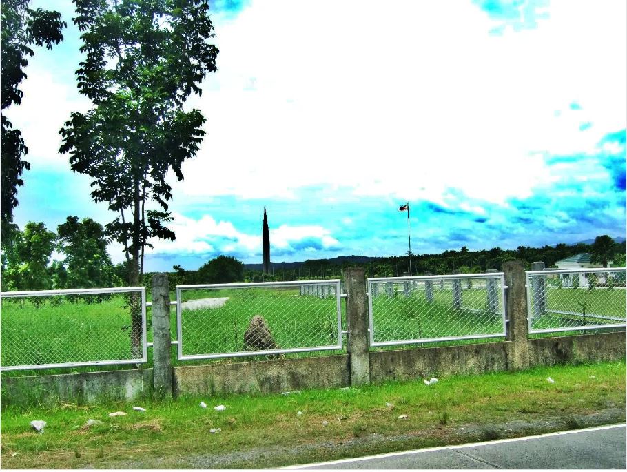 Zf703. 2008-01-17 only a few hundred feet further from the US Military Reservation Marker and the Death March Marker #112 is the entrance to the Capas National Shrine. We see the obelisk! This is a quote from Wikipedia: Click here for the URL! en.wikipedia.org/wiki/Capas_National_ShrineOn 9 April 2003, a 73-metre (240 ft) obelisk symbolizing peace[4] and new memorial wall were unveiled on the grounds of the former internment camp. The obelisk is surrounded by a three-segmented, black marble wall engraved with the names of more than 30,000 Filipinos who were incarcerated in the camp. There are also statistics about the total numbers of prisoners and deaths, together with poems for peace. 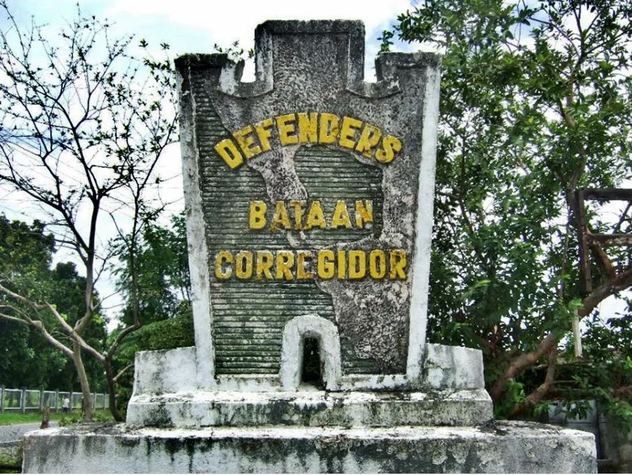 Zf704. 2008-01-17 The Philippine Defenders of Bataan and Corregidor placed a Memorial Marker here at the former Boundary of the Camp O'Donnell Military Reservation. And the Death March Marker #112 is also here. 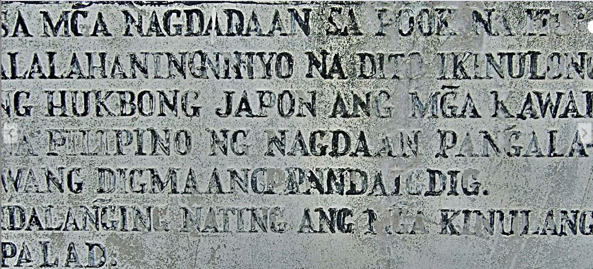 Zf705. 2008-01-17 The Philippine Defenders of Bataan and Corregidor placed a Memorial Marker here at the former Boundary of the Camp O-Donnell Military Reservation. This is the plaque under the icon in the previous image; I wonder what the plaque says? =============================================== URLs of a Museum of History and Historical Markers About 29 Images about the US Mil Boundary Marker in my Photobucket: app.photobucket.com/u/PI-Sailor/a/5d829075-5ff0-4e8e-b9b9-50ed56c9e13dWho knows a little Spanish? Corregidor Forum Page. corregidor.proboards.com/thread/203/who-knows-little-spanishRhonie Cauguiran Dela Cruz, Facebook page www.facebook.com/rhonie.d.cruzBamban Museum of History / Bamban Historical Society, Facebook page www.facebook.com/bambanmuseumOfficial Page of the Bamban Historical Society and Bamban Museum of History. The Museum is privately owned by Rhonie Dela Cruz with Bamban Historical Society members as volunteers. All official announcements, p schedules and events will be published on this Page. The Page also showcase the humble beginnings of BHS and the Bamban Museum of History and the events, activities undertaken since 1999 up to present.. heyplaces.ph/095590/Bamban_Museum_of_History_/_Bamban_Historical_SocietyCamp O’Donnel, Wikipedia en.wikipedia.org/wiki/Camp_O%27DonnellRhonie’s Blog Rhonie Cauguiran Dela Cruz is the leader of the Bamban Historical Society (BHS) and its Bamban Museum of History; where local history comes alive. This is the URL for the Museum: museumofhistory.blogspot.com/2008/09/bhs-bamban-museum-of-history-where.htmlKarl’s webpage about these U.S. Military Boundary Markers. Uploaded to K’s web, Central Luzon, Tarlac: philippine-sailor.net/us-military-boundary-markers-on-luzon/ |
|


 ??
??