|
|
Post by The Phantom on May 23, 2009 21:23:12 GMT 8
Some ifs..........
If regular trolley service was established on one rail through Malinta, wouldn't it be possible that another rail line inside could have been needed for the construction of the laterals?
Thus taking out the debris from the tunneling without interfering with regular Trolley schedules?
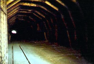
See picture D provided by Fotz showing the rail line on the right coming out of the tunnel entrance going up a ramp with a rail car below.
Are they bringing out the lateral rock debris, dumping it on the rail cars, and using it on the road system as they had originally done when the same area was a rock quarry?
Very compelling pictures one and all.
|
|
|
|
Post by batteryboy on May 23, 2009 22:13:14 GMT 8
Hi Batterboy You have solved the problem that arose in September 2008, hence the first post in this thread. The 1932, 1935 and 1936 maps of Corregidor show one tram line (track) through Malinta tunnel. However, the "as of 30th June 1934" plan of Malinta Storage System displayed two sets of track embedded in the floor of the main tunnel. This is only in a small portion of the plan and only present as a section of the tunnel. The plan showed the Malinta main tunnel construction as complete. The most well known of the pre-war photos of the western portal, however, shows only one track outside the tunnel. This was probably correct when that photograph was taken. So, I now know the two tracks went straight through Malinta by 1934, although it is probable that only one was in use for some time after 1934 and probably up to and after 1936 (at least). I'm guessing the western end of second tracks joined the first before reaching the railway bridge near the Church and Postal Exchange. Outside the Malinta tunnel eastern portal, I'm wondering if the second line again joined the first not far from the tunnel? If this is the case, Rails to Doomsday (page 40) is correct in that there was a main line and siding in the Malinta tunnel. Regards mapmaster Hi Mapmaster, After fiddling with batteryboy's "shelf of doom", I have found a memorandum to a certain Colonel Eltinge, dated May 26, 1921 from the Quarter Master Corps Office, Head Quarters, Philippine Department that mentions about the trolley line inside Malinta Tunnel. Subject: Malinta Hill Tunnel proposed for Fort Mills. Paragraph No.1 mentions: "In the Annual Estimate from Fort Mills, recently submitted, there was included a proposition to tunnel Malinta Hill and provide bomb proof storeroom leading from this tunnel. The entrance to the tunnel would be in the neighborhood of the present rock crushing plant and would extend through under the hill to connect with the tactical road leading to Kindley Field (the new Air Service project) and to the defenses on the tail of the island. It is proposed to make the tunnel about 650 feet long, 16 feet wide and 19 feet high. The roof will be arched. The tunnel would have concrete walls, roof and floor. The would be placed on a grade so that natural ventilation would result. A single trolley line is planned for the original installation but space is provided so that a double track may be installed later. Four storerooms are to lead from this tunnel, each storeroom to be 40 feet by 80 feet in the clear with an arched roof and concrete lining. Lighting, drainage, and ventilation would be provided for these rooms as well as light for the tunnel.If you guys want me to post the rest of the letter, let me know. Cheers, |
|
|
|
Post by fots2 on May 23, 2009 23:00:29 GMT 8
When they talk about four storerooms, the tunnel plans changed drastically for some reason before construction was started the next year. Are any maps included? Please continue batteryboy.
|
|
|
|
Post by batteryboy on May 23, 2009 23:52:05 GMT 8
Can we come to play at your house someday??? Hi Fots, Sure, you are more than welcome. Sames goes with the rest of the gang. We can easily invade EXO'splace 300 meters down the road as well. As requested, here is the rest of the letter. 2) The bomb-proof storerooms would be invaluable in time of war and the tunnel could be used as an emergency hospital. There is no bomb-proof storage for supplies available, and Malinta Hill is the logical place for such a base. This hill is ideal for bomb-proof storerooms and magazines. It is adjacent to the terminal and in time of war could be entirely honeycombed with underground storerooms.
3) The present road around Malinta Hill that furnishes the only good road to Kindley Field and the tail of the island is so situated as to be easily rendered useless by a shell striking any part of the South slope of the hill. Further, this road is exposed to the open sea and is likely to recieve shell fire from long-range guns of ships making an attack.
4) The post people state further that the rock taken from this tunnel would be utilized in the repair and maintenance of Post Utilities. There would thus be an slight saving in the construction because it would not be necessary to dispose of the material excavated.
5) The estimated cost of this work is $650,000.00. It is understood that this estimate was carefully prepated by the post authorities and no doubt is approximately correct. Some changes may be necessary in the sizes of the rooms that will result in a slight change of the estimated cost.
6) The arguments for this storehouse are essentially tactical. The reaons become apparent when a study of the storage facilities of the entire island is made. There is no question that additional storage must be provided generally, and it appears that it would be more logical to make bomb-proof space at somewhat additional costs than to place storehouses in the open that are likely to be destroyed during hostilities at the time supplies will be needed.
W. A. Danielson
Assistant Quartermaster |
|
|
|
Post by fots2 on May 24, 2009 8:30:43 GMT 8
I am continually amazed by your 'shelf of doom'. It should be rated as a national treasure.
Thank-you for a the information.
|
|
|
|
Post by EXO on May 24, 2009 21:09:53 GMT 8
Something in this photos reminds me of the way I recall (seem to recall?) Malinta Tunnel during my initial visits in the early 1970's - pre the resleeving project. It might be wishful imagination, but... I would like to know when that resleeving project took place. Fots mentions "possible debris on the tunnel floor." I agree, and venture that this debris easily could be covering evidence of the second set of rails, so it can't be illustrative of any "one rail theory." |
|
|
|
Post by mapmaster on May 28, 2009 17:53:21 GMT 8
Hi EXO and All
In July 1977, William H. Bartsch visited Corregidor while preparing an article for After the Battle magazine. William was transported to and from Corregidor by the Philippines Navy. His visit included a tour of the Malinta Storage System.
William's article includes a number of photographs inside Malinta. One photograph is titled "Following renovation work during 1975-77, one can now see...." The concrete lining in the photograph looks fresh and there appears to be no gate /door on the photographed exit. The hint is that restoration work was continuing at this time.
This is the only reference, I can find, relating to a date/s for relining the main Malinta tunnel.
Can anyone offer more information?
Regards
mapmaster
|
|
|
|
Post by fots2 on May 29, 2009 13:10:21 GMT 8
Still looking but I have not found anything else yet.
|
|
|
|
Post by mgk1951 on May 30, 2009 9:00:20 GMT 8
Hi
A guide book titled "Corregidor" and published by CFI, gives the date of the re-lining project as 1976. The sentence in a section covering Malinta Tunnel is: "The main lateral and portals were rebuilt in 1976".
Regards
mgk
|
|
|
|
Post by mapmaster on Jun 1, 2009 12:33:29 GMT 8
Hi I've finally had time to digitise a further portion of the "Malinta Storage System - as of June 30, 1934" plan. The new completed portion is the cross-section through No 14 Ordnance Magazine and the inner most Gasoline Storage lateral. 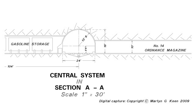 Zo019. Note from Karl: For some reason the original picture disappeared, as of today, 2019-02-14, it shows again but from a different server: The cross-section shows the arrangement of recesses, in the tunnel floor, for the tram car rails. As you can see, there are recesses for the two tracks (two rails per track). There is also a piped drain under the floor, draining the rail recesses. The original drain probably included (at floor level) a grate covered drop inlets, draining the floor, at the centre of the main tunnel. Going through the 1942 and earlier photographs, (attached to this thread) it would appear that the permanent arrangement of rails would have been for two tracks. The 1942 photograph and the 1934 plan support this theory. The other photographs depicting one track could depict a temporary arrangement through Malinta. It is possible to see the track raised onto railway sleepers in some of the early photographs instead of rails bolted into the recesses. Also visible in the earlier photos is a single tram car powerline above the single track, indicative of the single track. Note that there are two tram powerlines in the 1942 photograph. So, was the second track through Malinta part of a service to "rails end" near the 92nd Garage Area or was it a siding as indicated originally in "Rails to Doomsday by Charles S. Small"? Would it be necessary to have both "Up" and "Down" lines for the short distance of 600 metres from Malinta to the 91st Garage Area? Or is one tram car running "Up" and "Down" on the same line sufficient? Regards mapmaster |
|