|
|
Post by okla on Apr 12, 2009 23:41:15 GMT 8
hey fots...i somehow missed your reply concerning your age,etc. eleven trips to corregidor!!!man o man, and i cant even make one trip. my only shot was way back in 1953. i was stationed in the USAF just outside seoul, korea, and was up for rotation back to a base in texas. i tried to swing a transfer to clark field in the PI instead of returning stateside, but it fell thru to my great disappointment. that would have been perfect for me at the time. now a trip to the philippines is out of the question for various reasons, age, money, etc. way back when i was majoring in history at oklahoma state univ (on the GI bill) i vowed i would make it to corregidor-bataan, the little big horn battlefield in montana, and gettysburg. over the years i made it to the latter two sites, but alas, the jaunt to manila bay is for naught. this is why i depend on folks such as yourself to do me the honors for the very next best thing. it keeps my addiction for the place under control, for, as you so ably stated, "corregidor is addictive". keep up the good work.
|
|
|
|
Post by Karl Welteke on Apr 15, 2009 17:26:31 GMT 8
|
|
|
|
Post by fots2 on Apr 15, 2009 20:23:17 GMT 8
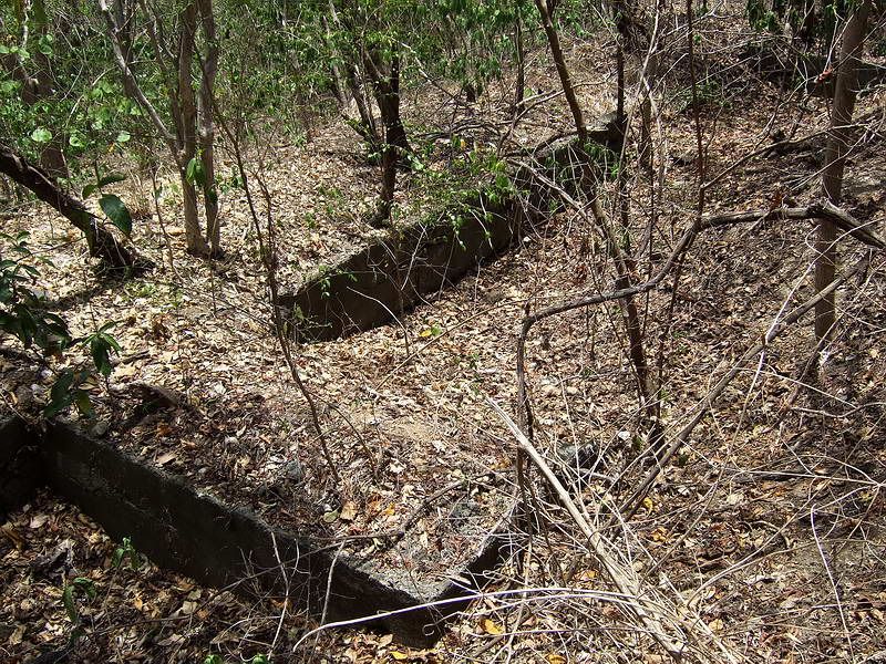
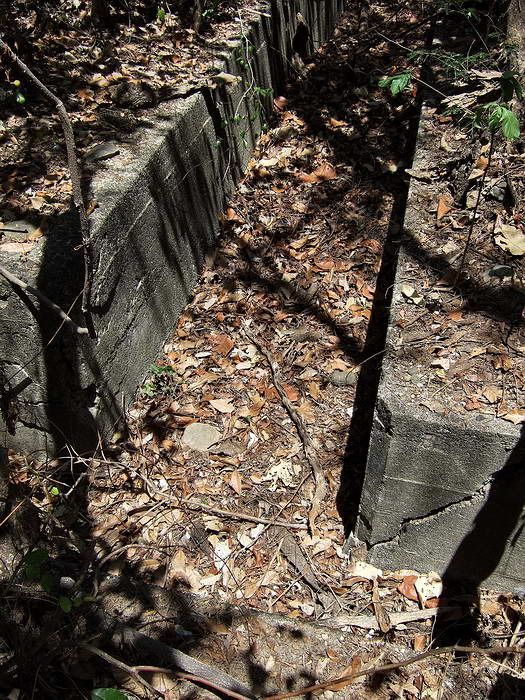
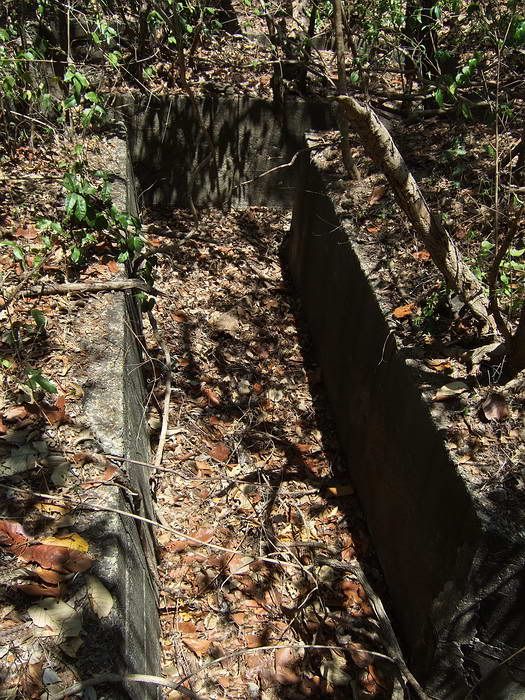
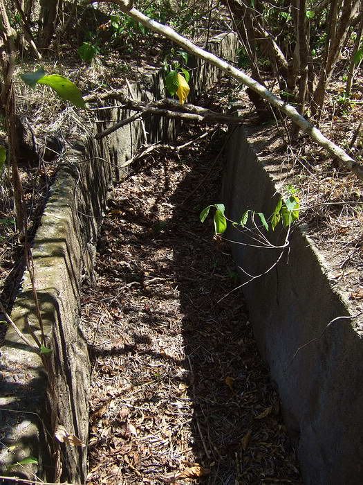
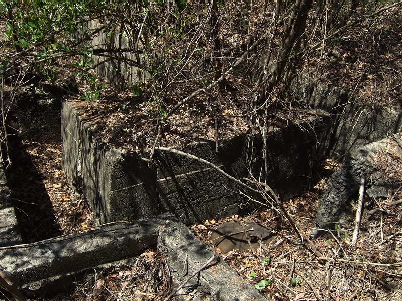
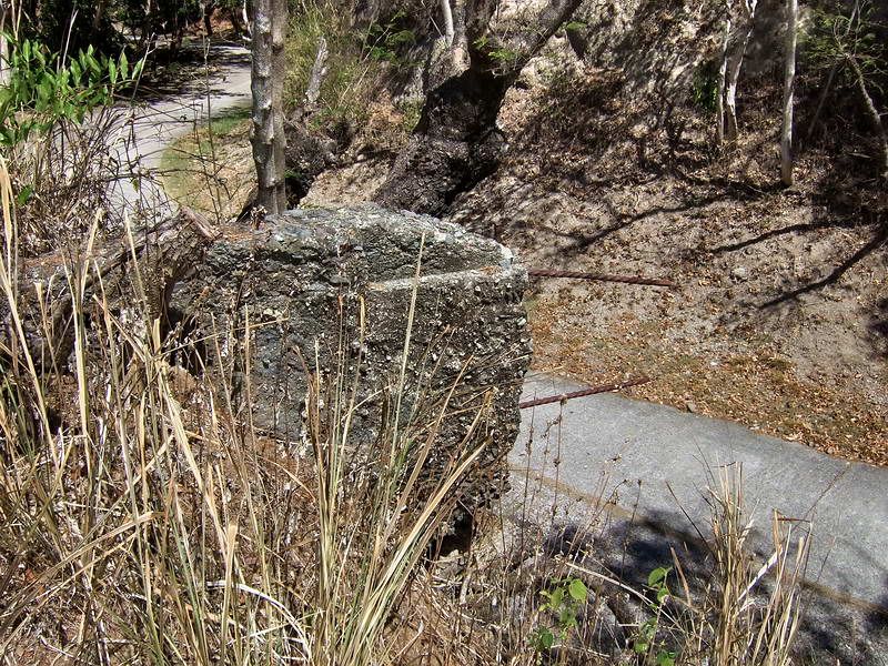
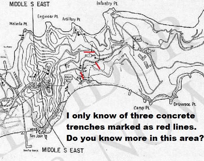 The above map is from Karl Welteke. Karl, This is the location of three of the five structures I came across a few days ago. The top one I knew of before but did not know what it was. One not one your map is a concrete trench system 38m long in three sections. It is north of the bottom one marked on your map. The second structure (small and mostly concrete ruins) is marked on the 1941 Emergency Defense map as a machine gun position. It is between the bottom one on your map and the missing one I just mentioned above. One comment about the bottom trench on your map. A section of it does go fairly north-south as you show but almost two thirds of it continues east along a ridge above the south coast. Part of this portion has a rectangular platform (possible machine gun position) and a 14m roof over part of the trench. I am almost finished some sketches of the trenches and then I will post them and a few photos. GPS waypoints were recorded and just sent to mapmaster today. He will put them on a map to show us exactly where all these positions are located. |
|
|
|
Post by The Phantom on Apr 16, 2009 4:50:55 GMT 8
Were those not the trenches that our troops fell back to in 1942? After the Japanese had taken Battery Denver and the other high ground around Water Tank Hill?
I have been to those trench locations also and think they would be another great place to retrieve from the jungles encroachment.
Done personally of course, with proper permission of course, lots of sticky thickets there, physical and political.
Hedge clippers/trimmers, not machetes, as I have been shown on this last trip, will do the trick just fine.
Done at sunrise to avoid the heat from all sides.
These historically important trenches are not far off the road the tourists travel today, but are unseen by all.
As I have seen by these great pictures, would it be now possible to get any pictures of the dirt slit trenches lined by steel barrels in Battery Denver in the summer also? So thick and dark in that area in February.
Ah, Corregidor in the summer, no better time to be up early and done quick........
A cold one and some fried bananas in the cool breeze near North Dock at noon.
Has the top entrance to Battery Denver's tunnel been found yet?
I was amazed seeing the lower bottom road entrance, and that the tunnel is cut through old Lahar, a thick gray sand, (see Mount Pinatubo eruption recently), from millions of years ago?
The tunnel goes straight into the hill and was lined with old railroad ties, some still in place. At the end the tunnel goes almost straight up to Battery Denver proper.
A ladder system long gone?
Clear evidence of Corregidor past as a volcano at one time, as we know.
Or was this Lahar from the explosion of any number of other past eruptions of the islands other volcanoes?
Mount Mariveles, Taal, Pinitubo?, to name a few close by.
This is the only big Lahar formation I have seen on the island.
The Lahar's location is on the northern backside of the Water Tank Hill area which is north of Corregidor's old crater, located between Caballo Island and South Shore Road along Malinta Hill, west to Geary Point and east to Hooker Point.
A very large crater indeed, all under Manila Bay at this time, and still peppered with pre 1942 silver coins I suspect..........
|
|
|
|
Post by Karl Welteke on Apr 16, 2009 5:10:12 GMT 8
Thanks John
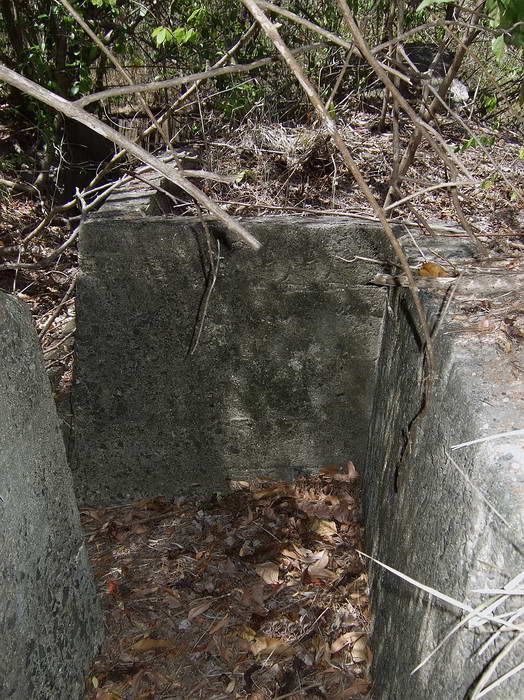
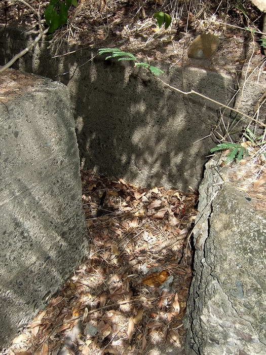
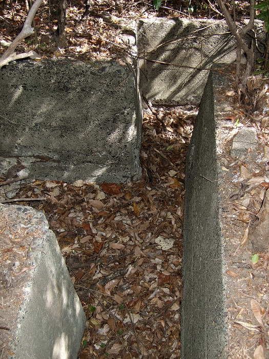
That helps, so there is a lot more in the area of my south-west one. I also noticed a roofed section on this one, the one of my three on my map which I now call the SW one. It was built with rails as support. The last trench pic on this threat looks like the south end of the roofed section I just talked about. I also found the underbrush to be a big pain in the kneck.
The SE one on my map runs prallel to the path down to the club house of the 92 Garage area.
My North one runs parallel (on east-west axis) to and south of the main North Road, just a little west of RJ (Road juncture) 43.
Karl
|
|
|
|
Post by fots2 on Apr 16, 2009 13:51:29 GMT 8
Here are sketches of the four trench systems mentioned above. (NOTE: distance figures are rough 'paced off' measurements)  Trench #1 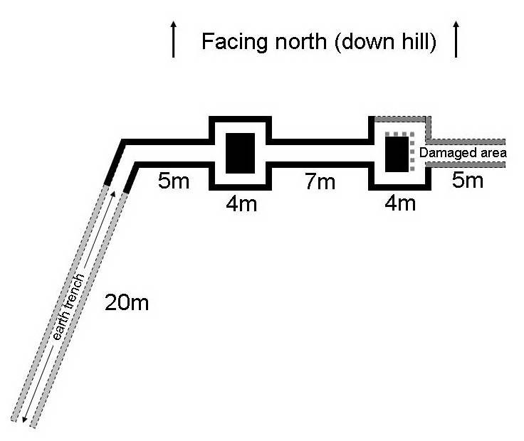 Trench #2  Trench #3 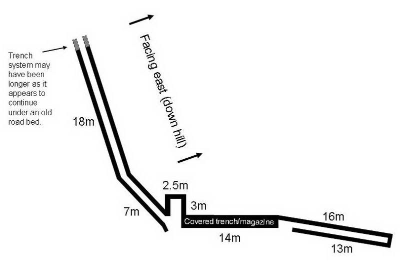 Trench #4  Eleven April 2009 GPS waypoints, by fots2, each marked by an 'X' on 1932 Corregidor map. The 1941 Emergency Defense Map positions are marked in red. A dot with arrow denotes a machine gun. A dot denotes extra machine guns. 37 denotes a 37mm cannon. Trench number 3 does not appear to be part of the 1941 defenses. Trench number 2 appears to be the 1932 mapped trench. Trenches 1 and 4 appear to be post 1932 trenches. The GPS reading and original maps concur somewhat surprisingly. |
|
|
|
Post by fots2 on Apr 16, 2009 20:14:57 GMT 8
Mr. Phantom,
If they were cleaned up, the two trenches beside the road to the Malinta east entrance would clearly be visible to the day tour crowd. It is another little bit of history they could see without even leaving their seats.
Pictures of the trenches and defenses along the ridge by Battery Denver are a good idea. I don’t think any of our group has ventured that way since out two trips there in February. There is still more to explore in that area.
Your early morning plan of attack sounds like a good one. It is certainly hot in the jungle now and you go through water fast.
|
|
|
|
Post by okla on Apr 16, 2009 22:48:55 GMT 8
hey fots....again, i say great stuff. this latest trench info just makes me all the more regretful that when the US granted independence to the PI back in 1946 that there wasnt some type agreement/treaty/etc whereas the US park service could have been in charge of corregidor and the other manila bay forts. the PI would have sovereignty and all that good stuff, but the US park service could have been in control of perserving corregidor and its remaining relics. these newly found trenches and other vestiges of that period, still hiding in the jungle, would be in full view for the "corregidor geeks", such as ourselves, and others to view and enjoy. man o man, one wonders what is still out there just waiting to be discovered by diligent souls such as yourself. good works shouldnt go unrewarded to folks like you, mapmaster, karl and too many others to list here.
|
|
|
|
Post by fots2 on Apr 17, 2009 14:14:16 GMT 8
okla, you are most welcome for any photos or info we post here. A few years ago, I still remember speaking to a day tourist while waiting for the boat back to Manila. He had had a good tour and seen everything Corregidor had to offer. I was like that on my first couple trips until I started to do some research. Today, after eleven trips my list of places to visit is as long as ever. It is great that guys such as yourself continue to add to my list. (Tailside cemeteries etc are next)  I expect you have noticed that the people who explore Corregidor and post here are a good bunch of guys. Many have varied backgrounds but have a common interest....San Miguel Beer. Well ok, that too. They are full of information and know a lot more detail of what/where things happened than me. I am more of an explorer and take my little pocket camera along to capture the area. Keep the ideas coming. Good day. |
|
|
|
Post by fots2 on Apr 17, 2009 14:42:33 GMT 8
|
|