|
|
Post by fots2 on Aug 3, 2009 17:58:24 GMT 8
This photo is labeled “Japanese soldiers batter Corregidor with captured 12-inch guns.” Is this correct or is the photo mislabeled? The gun looks the same as the ones at Smith and Hearn. Did the US have permanent pre-war 12” gun batteries on Bataan? Where was this photo taken? Is there anything left of it to see today? 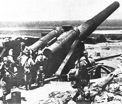 From “The Fall of Corregidor” online at: www.fourthmarinesband.com/photos_fall.htm |
|
|
|
Post by batteryboy on Aug 3, 2009 19:25:05 GMT 8
This is the photo of Battery Smith in Corregidor during the surrender of the island and was mis-labeled in some books and magazines.
The only big fix seacoast gun is the 8-inch M1888 gun emplaced at Saysain Point in Bagac, Bataan (the other half of Battery RJ-43) and a 6-inch Naval gun on Pedestal at Mariveles. Other than that Bataan had mostly 155mm GPFs and two 155mm Howtizers that served as heavy artillery.
The Japanese brought their own heavies such as the 240mm Howitzers. Some also mislabeled this as a Japanese 240mm.
Regards,
|
|
|
|
Post by fots2 on Aug 3, 2009 21:21:02 GMT 8
Thanks batteryboy.
I guessed the photo was mislabeled because it there were 12" gun batteries in Bataan I expect I would have heard about them.
Would anything remain today of the two gun emplacements at Saysain Point and Mariveles?
I never have asked you this. Other than the Death March route and the Mount Samat National Shrine, I have not explored Bataan at all. Is there anything WWII related worth visiting in Bataan?
|
|
|
|
Post by batteryboy on Aug 3, 2009 21:52:06 GMT 8
We visited Saysain Point in 2001. The owner of the land had the area bulldozed so both emplacements were under two feet of earth but we were at the exact positions. The one at Mariveles is long gone. Much has change on Mariveles. Imagine, an airfield used to be there as well.
Other than Mt. Samat which have some armaments, the old highway (route 110) leading to Bataan would have markers. For me visiting the places where the actual battles happened is worth visiting but they are devoid of any military hardware.
I will be visiting there in couple of weeks to visit the five (5) airfields there used during the war. Ofcoure they are also long gone but just to be in the location still excites me.
Regards,
|
|
|
|
Post by okla on Aug 3, 2009 22:36:10 GMT 8
hey guys....vic (vee vee) of the philippine scout site is what i would call an "expert" on the abucay line. he was there recently, as i am sure you know, and prowled all over the area with some locals. he was shown some artifacts,etc from the area. abucay area is where one has to let the imagination take charge, i would assume. i possess such an imagination, but sadly will never get to put it to use in bataan or on corregidor, but you guys and this board suffice in my old age. postscript....i would think the area containing the "pockets" fights would be of interest. i have read somewhere that the foliage,etc has all been cleared over the years and the scene of those horrific struggles looks completely different making it double tough to locate the exact locale, but with some local help can be done. another case of having to use the imagination.
|
|
|
|
Post by batteryboy on Aug 4, 2009 8:05:12 GMT 8
Hi Okla,
In the 80s, I visited most of the battles sites in Bataaan, (From Layac, to the Morong Abucay Line, Pilar-Bagac Line, Mt. Capot, Trail 2 etc.) and even to the Points and in some extent the area Pocket fights Although I am not really an artifacts guy, my colleagues have dug up a number of arctifact ranging from USAFFE gear to Japanese stuff. Even the old obstacles were there.
Regards,
|
|
|
|
Post by victor on Aug 4, 2009 8:29:55 GMT 8
Hi Batteryboy, how accessible were the points even back then? Did you have to take a banca or were there trails?
Did your companions have metal detectors?
|
|
|
|
Post by okla on Aug 4, 2009 11:01:31 GMT 8
hey batts...wonder if you would straighten me out on a small matter here. dont mean to question a feller who has beat the bushes all over bataan, but didnt the abucay line run from mt natib to abucay area on the manila bay shore on the east and the western line (for lack of a better name), stretch from the south china sea at mauban to the slopes of mt natib?  ?this being the point where genl wainwright's I corps right flank was turned and the reverse was true in II corps where parker's left flank was turned on those easterm slopes of mt natib? the way i have it morong was further to the north and actually not part of the abucay-mauban line (if that is what i might call it). just another little tidbit about bataan/corregidor that continually nag at me, but make my "golden years" more interesting and not as boring as many of my ancient buddies are experiencing. thanks for anymore enlightenment you so kindly have showered upon your inquisitive old goat of a friend way out in oklahoma. |
|
|
|
Post by fots2 on Aug 4, 2009 12:49:10 GMT 8
Salamat for the information batteryboy, okla and victor.
Perhaps the best remaining reminders of the war there are older people and I am sure they are disappearing fast too.
Even if there is not much left to see, it still would be great to see the areas where these battles occurred.
|
|
|
|
Post by batteryboy on Aug 4, 2009 13:27:46 GMT 8
Hi Batteryboy, how accessible were the points even back then? Did you have to take a banca or were there trails? Did your companions have metal detectors? It took us four days to cover all the "points of interest". We started out in bancas and made our way to the others via cut trails. In places where we believe we cannot pass via land, we go again via banca. Some of the promontories are confusing as they look alike. We had a local who knew the places like the back of his hand. Its takes a while to determine where you really are. Yes, two of them had metal detectors. On the surf and rocks, they even found several shell cartridges, and even two mortar rounds. I kept my old sketch. will post it later. |
|


 ?this being the point where genl wainwright's I corps right flank was turned and the reverse was true in II corps where parker's left flank was turned on those easterm slopes of mt natib?