Post by fots2 on Dec 24, 2009 16:16:17 GMT 8
The trek from Middleside to James Ravine following the road to the water pumping station is a very nice walk. To get to the �Bombproof Infantry Quarters� you go past the pump station. There is not much of a path and you almost have to know from experience where the tunnel is. A first timer would have a hard time finding it.
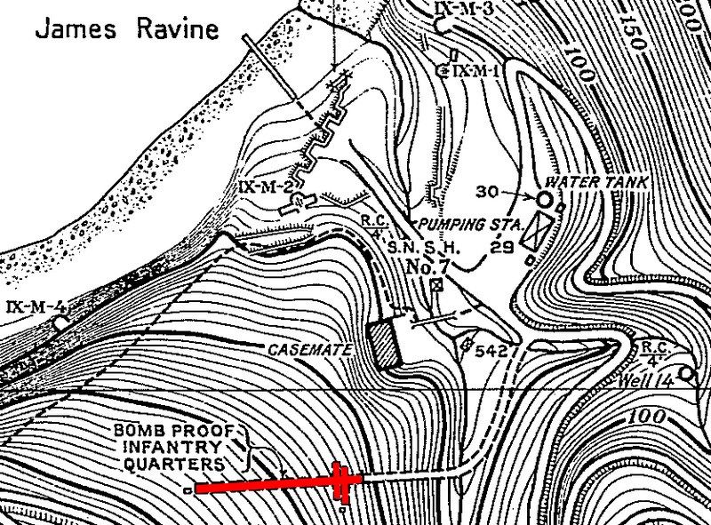
Map of James Ravine. The Bombproof Infantry Quarters is in brown at the bottom.
After crossing the bridge over a small stream, there was a long walkway with sloping concrete walls up to the entrance. Remnants of these destroyed walls are still there but the walkway is full of soil, trees, branches and vines.

As you approach the entrance you will see the concrete face of this 1918 tunnel.

Closer view of the concrete tunnel entrance.

Looking down into the tunnel entrance. Near the bottom is the metal beam across the top of the tunnel doorway. The narrow slit opening is the top left corner of the doorway therefore most of the entrance is filled with soil and rocks. Above the beam (with the vertical rebar) is an air vent.
Last year I was here with The Phantom and at that time there was too much debris in the narrow slit entrance to get in or out safely. The entrance was almost fully sealed by soil and debris and only the very top of the doorway was still open. You can see that metal rebar is sticking down and I had visions of getting stuck trying to slide through there and not being able to breathe. Not a good feeling. Self preservation kicked in so we moved on.
Last month the slit was as narrow as ever but the mud and soil was now soft due to the recent heavy rains. It took half an hour down there but I made a space large enough to get through with a six inch margin.
After looking in for slithering tunnel residents, I found none to be at home so I slid in on my back. Once you are past the beam above the doorway, you can stand up because the ceiling is very high and rounded. Walk down a rubble slope to get to the concrete tunnel floor.

View from inside the tunnel back towards the entrance. At the soil near the top of the doorway, notice the outside light shining on the centre part. This is the small area I cleared away so I could get inside the tunnel. The air vent with the vertical bars can be seen at the top.
Standing still for a moment to take it all in, you will notice that the tunnel is very humid and water is dripping near the entrance. If you lightly tap two small stones together, you will mimic the sound of hermit crabs which usually is the only sound you hear in tunnels like this. On the floor are broken pieces of concrete, lumber, bottles, metal springs and crumpled metal. Seems strange considering the humidity but I don�t remember any smell in this tunnel.

Hermit crab.
If any infantry actually did spend time living there, it must have been terrible living conditions. Even with a light breeze blowing through the tunnel when I was there, it was not comfortable at all. I imagine that it would take considerable ventilation to keep excessive humidity out of this place.
The first thing you notice looking further into the tunnel are huge damaged sections of the concrete lining. It is collapsed in places and bare rock is visible. Also, two short approximately 6 to 8 metre laterals can be seen on each side of the main tunnel. Parts of the walls are blackened as if they were burnt many years ago.
EXO tells me that 1st Platoon �E� Company was clearing James Ravine in February, 1945 and found many Japanese soldiers in this tunnel. I have also read that napalm was used in this ravine but I have no idea if it was used at this specific location. Later on you will also see blackened concrete at the rear of this tunnel where a large air shaft goes up to the surface.
You will notice that the map shows asymmetrical laterals, two on each side, directly opposite each other. My observation is that there are two nearly identical laterals on the south side however the south-east one is slightly deeper. On the north side, the north-west lateral is two or three metres deeper than the north-east lateral.

View of the two short laterals on the left (south) side. The one on the left is slightly deeper.

Straight in view of these two laterals. Note the arched rear roof of each of the laterals, the concrete wall between them has been destroyed.
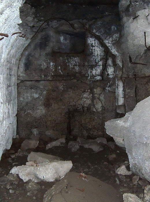
Close-up view of the south-east lateral. An air vent angles towards the other lateral.
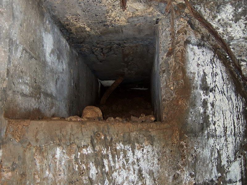
Looking into the rear air vent you can see that it is full of debris.
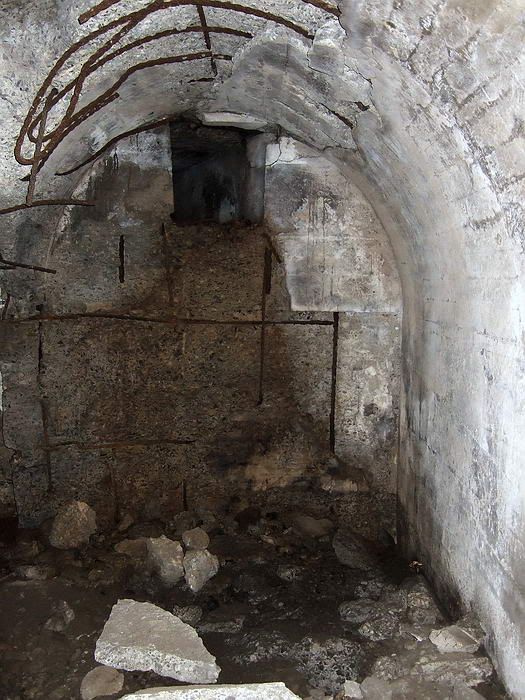
Close-up view of the south-west lateral. This air vent angles towards the previous lateral and is also sealed by debris. I assume the shafts joined at some point as a single vertical shaft is shown on the maps at the surface.
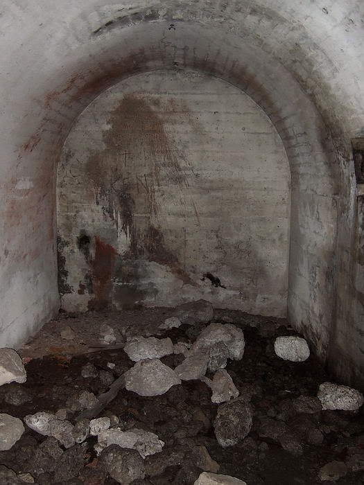
View of the north-west lateral taken from the main tunnel. Note part of a rectangular opening in the right hand wall that is a 2 or 3 metres from the rear wall.
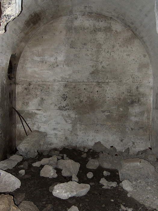
View of the north-east lateral taken from part way into it. Note the same rectangular opening, this time almost touching the rear left side wall. This lateral is shorter that the other one.
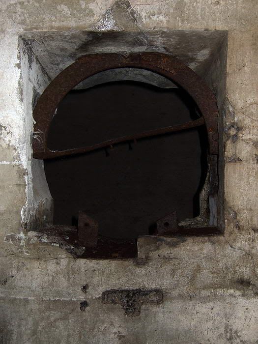
Close-up view of the rectangular opening between the two north side laterals. The bent circular metal frame suggests to me that it housed a ventilation fan.
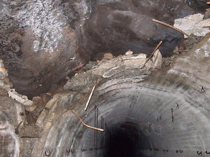
The original rock tunnel can be seen through a big space where the concrete lining is missing. The start of the south-west lateral is to the left.
The original map does not show an offset between the north and south side laterals along the main tunnel.
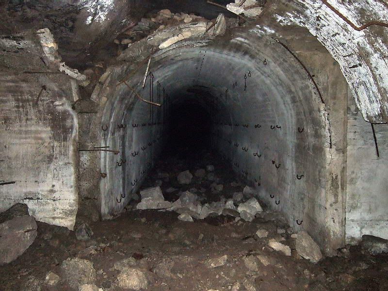
Looking further into the main tunnel, offset laterals on each side.
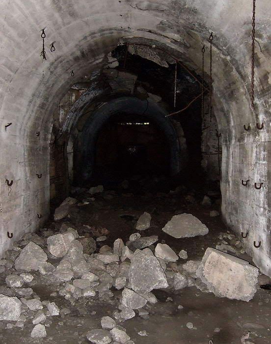
Just past the laterals I took this photo looking back towards the entrance. You can see a large piece of the tunnel roof missing above the laterals.
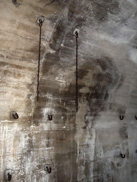
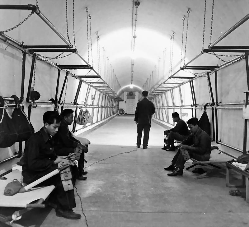
Chains and bunk hooks.
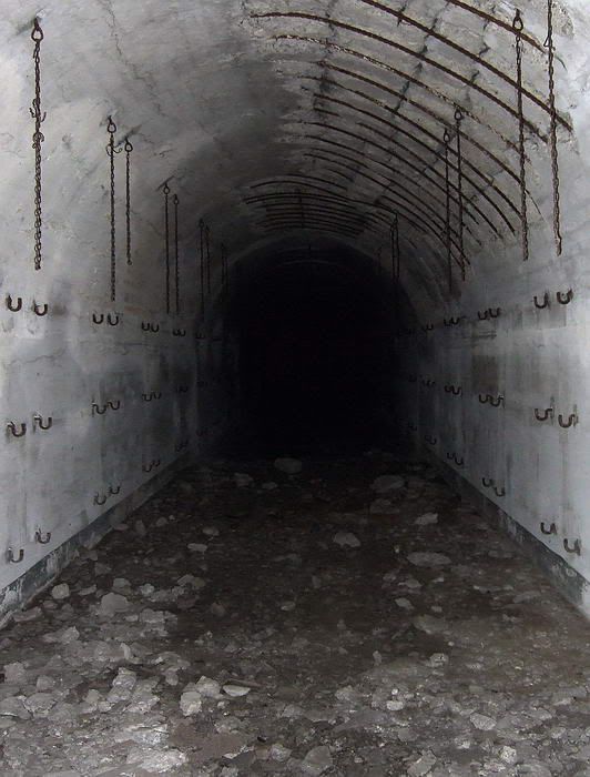
Looking down the main tunnel. On both sides chains supported three sets of bunks at each position.
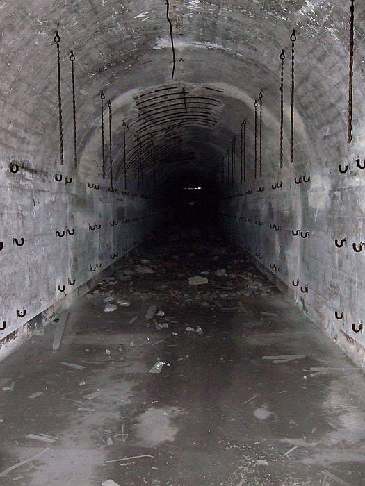
This view was taken approximately half way from the end of the main tunnel looking back towards the entrance.
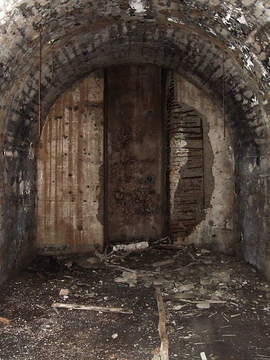
Here we see the end of the main tunnel with a vertical air shaft up to the surface. This air shaft is the same size as the ones for Malinta Tunnel. Note that the concrete is blackened in this area.
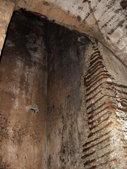
Another view of the air shaft taken at the rear tunnel wall.
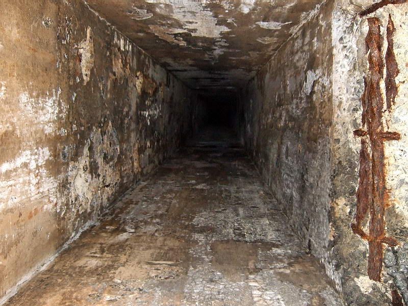
Looking vertically up the air shaft.
Using mapmaster�s 5 ft contour interval map, the difference in elevation from the tunnel entrance to the surface air shaft is 55ft plus or minus 5 ft. This photo shows no sunlight shining at the top even though I can feel a breeze coming down the shaft. At the time I thought that there must be a cap on the top of the shaft with small angled side air vents creating the breeze. Later that afternoon I saw that the top of the shaft is blown off and is wide open to the light.
Inside the tunnel the airshaft is at the rear wall but on the map at the surface, the airshaft is short distance from the end of the tunnel. There must be a horizontal section to this shaft.
On the way back out, I notice a definite slope to the tunnel floor as I head down towards the entrance. This is a common tunnel feature to assist in proper drainage.
After finishing inside the tunnel, I headed up on top of the hill to photograph the air vent. It was relatively easy to find but I missed it first try and had to backtrack for a few minutes.
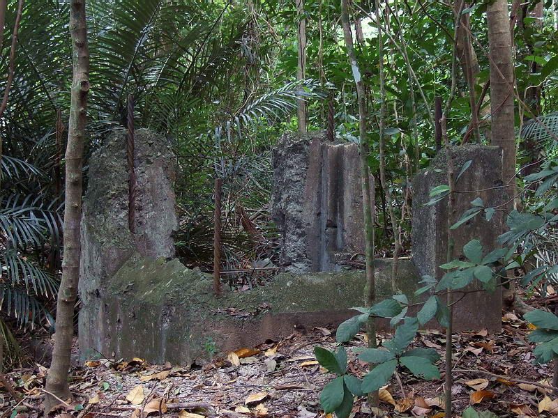
Here is the large air shaft at the surface.
The top is missing and looks like it came to a very violent end. On three sides there is an angled air vent and the fourth side has what appears to be a large hatch or doorway. I do not know the purpose of this.
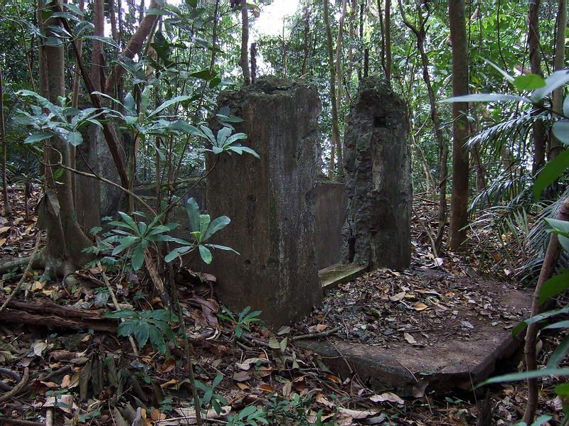
The air shaft from another angle.
Here you can see the side with what may have been some sort of hatch or door. It has a metal bars at the bottom. This side of the air shaft has a concrete platform attached to it.
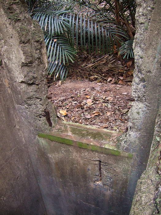
View across the inside of the vertical air shaft to the hatch/door. Note the metal bars at the bottom.

Another view of the interior of the air shaft. There are no metal rungs for a ladder down this shaft.
Time to go home. Not wanting to go down and then back up James Ravine again, the easiest way back to civilization seemed to be going south. I followed old roads to Battery Way and walked down to the hotel.

One of the 12-inch mortars of Battery Way. An October 2009 photo after a little shower.

Down to Bottomside and up the hill to the Corregidor Inn. The last few steps.

Map of James Ravine. The Bombproof Infantry Quarters is in brown at the bottom.
After crossing the bridge over a small stream, there was a long walkway with sloping concrete walls up to the entrance. Remnants of these destroyed walls are still there but the walkway is full of soil, trees, branches and vines.

As you approach the entrance you will see the concrete face of this 1918 tunnel.

Closer view of the concrete tunnel entrance.

Looking down into the tunnel entrance. Near the bottom is the metal beam across the top of the tunnel doorway. The narrow slit opening is the top left corner of the doorway therefore most of the entrance is filled with soil and rocks. Above the beam (with the vertical rebar) is an air vent.
Last year I was here with The Phantom and at that time there was too much debris in the narrow slit entrance to get in or out safely. The entrance was almost fully sealed by soil and debris and only the very top of the doorway was still open. You can see that metal rebar is sticking down and I had visions of getting stuck trying to slide through there and not being able to breathe. Not a good feeling. Self preservation kicked in so we moved on.
Last month the slit was as narrow as ever but the mud and soil was now soft due to the recent heavy rains. It took half an hour down there but I made a space large enough to get through with a six inch margin.
After looking in for slithering tunnel residents, I found none to be at home so I slid in on my back. Once you are past the beam above the doorway, you can stand up because the ceiling is very high and rounded. Walk down a rubble slope to get to the concrete tunnel floor.

View from inside the tunnel back towards the entrance. At the soil near the top of the doorway, notice the outside light shining on the centre part. This is the small area I cleared away so I could get inside the tunnel. The air vent with the vertical bars can be seen at the top.
Standing still for a moment to take it all in, you will notice that the tunnel is very humid and water is dripping near the entrance. If you lightly tap two small stones together, you will mimic the sound of hermit crabs which usually is the only sound you hear in tunnels like this. On the floor are broken pieces of concrete, lumber, bottles, metal springs and crumpled metal. Seems strange considering the humidity but I don�t remember any smell in this tunnel.

Hermit crab.
If any infantry actually did spend time living there, it must have been terrible living conditions. Even with a light breeze blowing through the tunnel when I was there, it was not comfortable at all. I imagine that it would take considerable ventilation to keep excessive humidity out of this place.
The first thing you notice looking further into the tunnel are huge damaged sections of the concrete lining. It is collapsed in places and bare rock is visible. Also, two short approximately 6 to 8 metre laterals can be seen on each side of the main tunnel. Parts of the walls are blackened as if they were burnt many years ago.
EXO tells me that 1st Platoon �E� Company was clearing James Ravine in February, 1945 and found many Japanese soldiers in this tunnel. I have also read that napalm was used in this ravine but I have no idea if it was used at this specific location. Later on you will also see blackened concrete at the rear of this tunnel where a large air shaft goes up to the surface.
You will notice that the map shows asymmetrical laterals, two on each side, directly opposite each other. My observation is that there are two nearly identical laterals on the south side however the south-east one is slightly deeper. On the north side, the north-west lateral is two or three metres deeper than the north-east lateral.

View of the two short laterals on the left (south) side. The one on the left is slightly deeper.

Straight in view of these two laterals. Note the arched rear roof of each of the laterals, the concrete wall between them has been destroyed.

Close-up view of the south-east lateral. An air vent angles towards the other lateral.

Looking into the rear air vent you can see that it is full of debris.

Close-up view of the south-west lateral. This air vent angles towards the previous lateral and is also sealed by debris. I assume the shafts joined at some point as a single vertical shaft is shown on the maps at the surface.

View of the north-west lateral taken from the main tunnel. Note part of a rectangular opening in the right hand wall that is a 2 or 3 metres from the rear wall.

View of the north-east lateral taken from part way into it. Note the same rectangular opening, this time almost touching the rear left side wall. This lateral is shorter that the other one.

Close-up view of the rectangular opening between the two north side laterals. The bent circular metal frame suggests to me that it housed a ventilation fan.

The original rock tunnel can be seen through a big space where the concrete lining is missing. The start of the south-west lateral is to the left.
The original map does not show an offset between the north and south side laterals along the main tunnel.

Looking further into the main tunnel, offset laterals on each side.

Just past the laterals I took this photo looking back towards the entrance. You can see a large piece of the tunnel roof missing above the laterals.

Chains and bunk hooks.

Looking down the main tunnel. On both sides chains supported three sets of bunks at each position.

This view was taken approximately half way from the end of the main tunnel looking back towards the entrance.

Here we see the end of the main tunnel with a vertical air shaft up to the surface. This air shaft is the same size as the ones for Malinta Tunnel. Note that the concrete is blackened in this area.

Another view of the air shaft taken at the rear tunnel wall.

Looking vertically up the air shaft.
Using mapmaster�s 5 ft contour interval map, the difference in elevation from the tunnel entrance to the surface air shaft is 55ft plus or minus 5 ft. This photo shows no sunlight shining at the top even though I can feel a breeze coming down the shaft. At the time I thought that there must be a cap on the top of the shaft with small angled side air vents creating the breeze. Later that afternoon I saw that the top of the shaft is blown off and is wide open to the light.
Inside the tunnel the airshaft is at the rear wall but on the map at the surface, the airshaft is short distance from the end of the tunnel. There must be a horizontal section to this shaft.
On the way back out, I notice a definite slope to the tunnel floor as I head down towards the entrance. This is a common tunnel feature to assist in proper drainage.
After finishing inside the tunnel, I headed up on top of the hill to photograph the air vent. It was relatively easy to find but I missed it first try and had to backtrack for a few minutes.

Here is the large air shaft at the surface.
The top is missing and looks like it came to a very violent end. On three sides there is an angled air vent and the fourth side has what appears to be a large hatch or doorway. I do not know the purpose of this.

The air shaft from another angle.
Here you can see the side with what may have been some sort of hatch or door. It has a metal bars at the bottom. This side of the air shaft has a concrete platform attached to it.

View across the inside of the vertical air shaft to the hatch/door. Note the metal bars at the bottom.

Another view of the interior of the air shaft. There are no metal rungs for a ladder down this shaft.
Time to go home. Not wanting to go down and then back up James Ravine again, the easiest way back to civilization seemed to be going south. I followed old roads to Battery Way and walked down to the hotel.

One of the 12-inch mortars of Battery Way. An October 2009 photo after a little shower.

Down to Bottomside and up the hill to the Corregidor Inn. The last few steps.


 ? I have always understood that the mortar was the last "big gun" on the "rock" to defy the Japanese invaders.
