|
|
Post by okla on Mar 10, 2012 1:05:06 GMT 8
Hey Phantom....Don't those steep flights of concrete steps follow segments of the original cable car path?  I have long visualized, in my mind, the thought of some of the Corregidor troopers, "carrying a full load on a long ago Payday Night", after missing the last trolley., trying to negotiate those stairways in their attempt to return to barracks before the morning Bugle. ;D |
|
|
|
Post by dmether on Mar 11, 2012 17:26:31 GMT 8
Is this the cable car? It's out of a corregidor photo album. Attachments:
|
|
|
|
Post by dmether on Mar 11, 2012 17:34:29 GMT 8
This also says it was taken on Corregidor. Looks like a cross on top of a building on the left. Attachments:
|
|
|
|
Post by okla on Mar 11, 2012 20:20:44 GMT 8
Hey dmether....I think that the latter photo is down on Bottomside where all the cable car routes converge, if I'm not mistaken.
|
|
|
|
Post by The Phantom on Apr 25, 2012 4:06:07 GMT 8
Okla I can only imagine having to walk up those steps with a full pack back then, or today.
Yeah it was part of the old Cable line as far as I know.
By the time the old Cable line was gone they had their new trolley lines I would imagine.
A huge work in progress for many years I suspect.
|
|
|
|
Post by The Phantom on Apr 25, 2012 4:57:14 GMT 8
dmether,
Both photo's are interesting.
The first photo looks like a regular trolley car.
I will need help from others here.
I have never seen a picture of a Cable car as they must be pulled up the steep grades with cables, I'm assuming they will be constructed differently.
The car in the picture looks like one that runs on electricity and is not pulled.
The grade at the starting point going out of Engineers ravine is very steep as in the section now being used as the steps okla mentioned.
That car could not go up those grades on electricity alone, I'm thinking.
Now the second picture is very interesting to someone who has been lucky enough to go to Corregidor.
I was exploring that area this trip trying to see how the present day location could have been what the picture shows so well.
A lot of the soil has been moved around and it appears there are still a few bomb holes in the area, some chucks of concrete.
The picture shows Bottomside as okla again has stated.
Not just anywhere on Bottomside but the main junction just below Skipper Hill,( currently southeast corner of the Hotel complex), where 2 tracks wrap around Skipper Hill going to North Dock from the area heading from Topside, and another line goes over the bridge to Malinta Tunnel.
The old church steeple is in the background. The present day church is still in the approximate location.
I can't say for sure but I think that building may be a 2 story one. It's first floor below the hill, with another set of tracks going under the bridge from North to South dock next to the first floor section.
I will have to check the map for building identification.
I have seen a picture of the building from the Malinta side in a prewar photo on this site.
In the past lots of interesting WWII artifacts were found where this building had been, ( now a stairway to nowhere made of trolley limbers).
The high concrete trolley bridge abutments still protect this area.
A battle in the location in 1945?
Also a first aid station in 1945?
Found in this small location where the building had been.
Several 50 caliber slugs-10.
30 caliber slugs- 25.
30 caliber ammunition casings exploded before being shot-12.
Fully intact Morphine bottles- 8.
Bomb fuses- 8.
Just west of this building is a set of barracks for NCO's.
Was this their work location?
|
|
|
|
Post by The Phantom on Apr 25, 2012 5:02:57 GMT 8
No not their workplace?
The building you pictured dmether is #474 on the 1932 map.
The Barrio Office.
|
|
|
|
Post by okla on Apr 25, 2012 8:30:37 GMT 8
Hey Phantom....An excellent report, as per usual. We can never learn too much about our favorite place on the planet (other than our homes and I would venture there are some among us who would question that statement). Cheers.
|
|
|
|
Post by EXO on Apr 25, 2012 9:56:45 GMT 8
my two cents worth, is that the pic is on one of those levels between the present road and the hotel; the lines going off to the left are on the down grade towards north dock; the line going off to the right will cross the bridge towards Malinta Tunnel. That, I think, makes the building the provost marshall's office. Is that image part of a larger one? POST SCRIPTMore reading: Ralph Forty has an article THE CORREGIDOR TRAMWAY at corregidor.org/chs_campbell/rails.htmTony Feredo has an article THE CORREGIDOR RAILWAY SYSTEM at corregidor.org/chs_feredo/rails.htm |
|
|
|
Post by fots2 on Apr 25, 2012 16:48:35 GMT 8
Hi dmether, Your first photo shows a trolley car that is electrically powered and not part of the earlier cable line. Photo #3 clearly shows the pole from the car up to the electrical line. 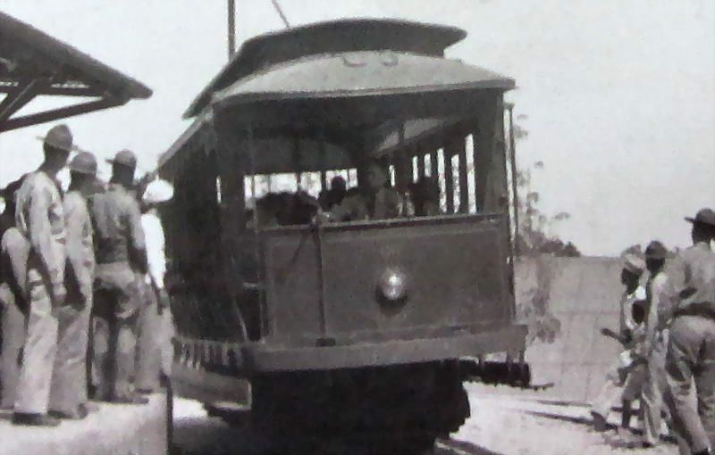 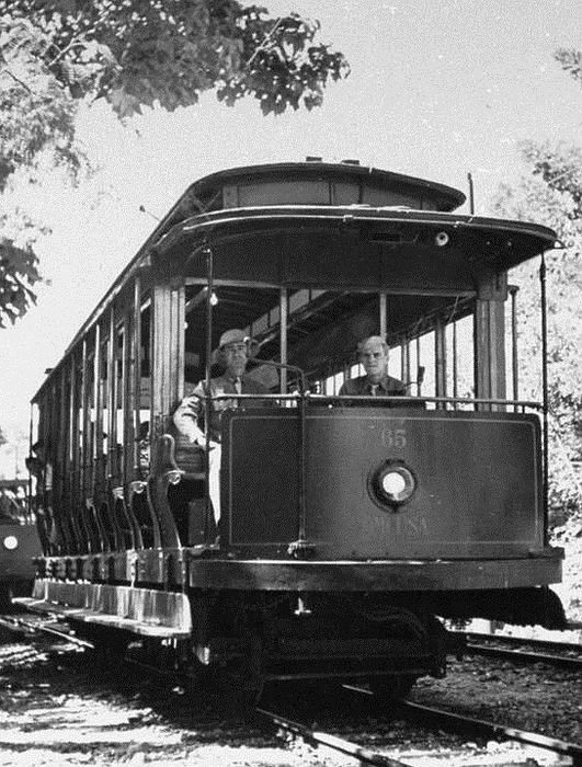  As for the second photo, I think Phantom and ExO have the location correct. Here is another photo of the same junction taken a bit further back. I expect this photo was taken years later due to all the extra trees in sight. In the two photos, note the tracks are identical and the power pole with the white (concrete) base in front of Bldg 474. In the first photo at bottom left, you can see the edge of the concrete walkway between the two sets of tracks. This is easily seen in the second photo. Even the opening in front of Bldg 474 is the same including including the ‘X’ shaped railing. 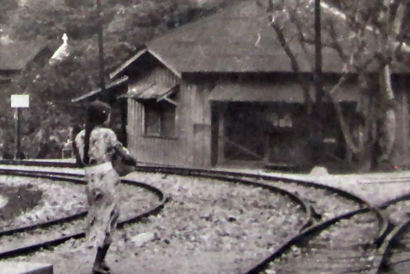 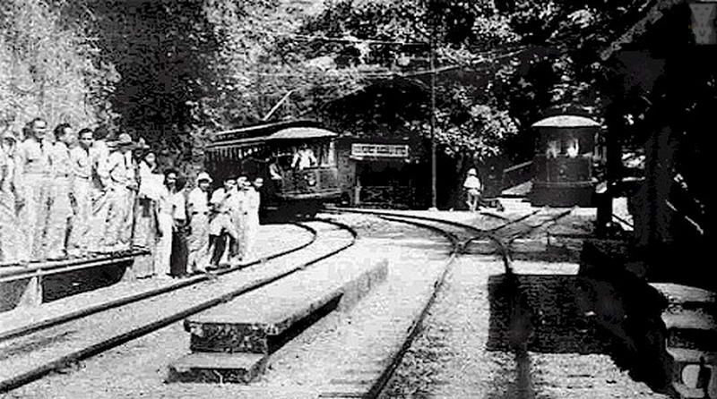 Here is a photo taken from the opposite direction showing the same trolley line junction. 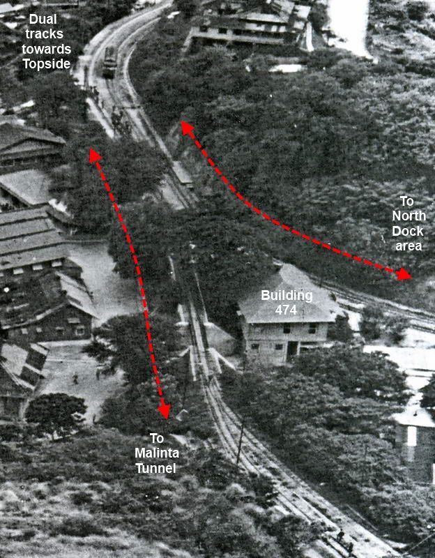 |
|


