Post by fots2 on Nov 26, 2012 14:16:17 GMT 8
On April 11, 1902, the islands of Corregidor, Caballo, Carabao, El Fraile in Manila Bay plus Grande Island in Subic Bay, were declared US Military Reservations. Included along with these islands was Olongapo in the province of Bataan and southwestern Cavite from Carabao Island to Limbones Island.

Islands of the Manila Bay US Military Reservation
The military purpose of Limbones Island was to provide ‘eyes’ 3.9 km/2.4 miles further out into the mouth of Manila Bay from Fort Frank. It had two tertiary Fire Control Stations for the 14-inch guns of Batteries Greer and Crofton. A communications cable was laid in the bay to provide direct voice contact between the Fire Control Stations and the batteries.
Limbones Island was never fortified and no one was stationed there permanently. Structures built included two concrete Fire Control Stations, a troop shelter, concrete steps from the beach up to the top of the cliffs, a concrete landing and a communications cable terminal.

Sketch made from a 1920 map of Limbones Island. (Courtesy Glen Williford)

Sketch of the two Fire Control Stations as they would have appeared in 1922. They should be simple rectangular concrete structures with a pedestal on the floor for mounting the Depression Range Finders. (Courtesy Glen Williford)
As far as I can determine, Limbones Island was not manned during WWII by either side. On January 5th 1945, B-24 Liberators escorted by P-40s bombed the island but I cannot find the reason for this attack. There is little information available about Limbones Island and it is rarely visited today.
In February of this year, Karl and I along with a group of CDSG members made everyone’s first trip to Limbones Island. We had come all the way from Corregidor and it was an expensive boat ride. Due to time limitations and some people not prepared for the dense vegetation, we turned back approximately 200 metres before reaching our goal of finding the Fire Control Stations. The trip was valuable though as it was great preparation for a subsequent trip. When the next time comes, we know where to land on the island, how to get up the cliff and in what direction to head when searching for the stations.

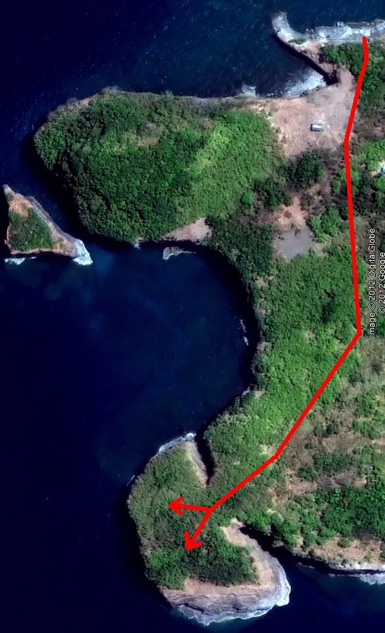
Google Earth satellite photo of Limbones Island taken in 2010. The island does not look overgrown in this view but it sure is when you are standing on it.

The island is nearly all cliffs and we only know of one easy way up…the old concrete steps. Our February hike started at the top right corner of the photo and my GPS track that day showed we made it almost 2/3 of the way there before abandoning the trip. The two Fire Control Stations are located on the bottom middle ‘arrow head’ shaped point.

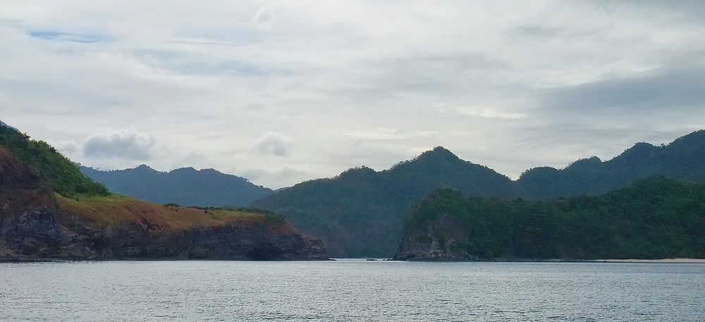
The profile of Limbones Island.
Here are some photos from the February trip:

A view of the southern end of the island as we approach Limbones.

The northern end of the island. A small house is visible above the cliffs.

The boat will drop us off here.

A closer view of the above photo showing remnants of a concrete landing, cable hut and steps up to the top of the island.

A wooden gangplank made for easy access to Limbones this day. This type of boat is not well suited for rocky coastlines, usually you get wet to the crotch getting ashore plus you have waves and slippery rocks to deal with. Factor balancing your gear into the mix and getting on and off some islands can be interesting.

Walking up the stone and concrete steps. The rectangular structure to the right is the Cable Terminal where the communications cable came ashore from Fort Frank.

Close-up view of the Cable Terminal and two conduits going into the water.

There is not much to see inside the Cable Terminal itself.

Looking back towards the boat. Bataan can be seen across Manila Bay.

The upper half of the concrete steps to the top of the island.

This is the same little house that we saw earlier from the boat.

It appears that no one has lived here for some time.
Heading inland towards the point where the Fire Control Stations are located, we passed a structure shown on the map as a Troop Shelter. The location is about correct for the shelter but this does not appear to be a 1920s era building. Obviously the new metal roof is not original.

Troop Shelter?

Interior view, note the new roof. There are no dates or other markings in the concrete walls to indicate their age.
The march from here to further inland was slow and as I mentioned earlier, it was decided to return to the boat before reaching our goal.
Preparation for a second trip to Limbones Island.
Last month Karl and I were on a three day WWII history tour. He drove and I tried not to get us lost. One “To Do” item of that trip was to drive to Santa Mercedes which is the nearest small village close to Limbones Island. There we wanted to find a man with a boat willing to take us to the island. We found him and the price was good so we exchanged contact information. Since Fort Frank is nearby we also added that to the itinerary.

Santa Mercedes is by far the most direct route for us to get to Limbones Island.
Soon the rainy season would be over and we could get serious about this trip. When a few good days in a row looked likely, we would go. Well, that time came last week. The nearest home base for us with accomodations would be Nasugbu, Batangas which is less than a one hour ride from Santa Mercedes. Nasugbu also has WWII history in that it was the location of the 1945 amphibious beach landing of the 11th Airborne Division in preparation for their drive north to help retake Manila.

Late afternoon view of Nasugbu, Batangas
Trip #2 to Limbones Island
Early last Friday morning, November 23rd, we drove to Santa Mercedes. It is a small coastal fishing village with only one partially paved road connecting it to anywhere. I get the impression that during the worst of the rainy season, by boat would provide their only outside contact. This will change soon though as a new modern two-lane road is being built in the area. The people are very nice and don’t seem to mind a couple strangers paying them a visit.

The road to Santa Mercedes is mostly good to very good but the last stretch is rough. This rock bridge is close to the village.

The village itself is at the mouth of a small river where a ravine reaches the coast.

Santa Mercedes in the distance.

Downtown Santa Mercedes.

Another view of Main Street.

Hazy early morning view looking inland.

A view of the beach.

On a point not far from Santa Mercedes we have a good view of Carabao Island (Fort Frank). Directly above Carabao you can see Topside on Corregidor through the haze. Mount Mariveles, Bataan is behind Corregidor.
The plan for today was a boat trip to both Limbones Island and Carabao Island (Fort Frank). We would allow seven hours total for both places. For some reason that I never understood, the boat departed and headed for Carabao Island. At the time it did not seem important but after spending four hours on Carabao and then travelling to Limbones, the waves were too dangerous for a safe landing. We took a good look but aborted due to concerns about the boat plus our own skins and equipment. Just four metres from the shore we decided to return to Santa Mercedes.
The seas were definitely calmer in the morning and we may have had no problem to get onto Limbones if we had gone there first. A local guy who accompanied us said mornings are better for Limbones but unfortunately this day we started in the opposite direction. Both Karl and I have been to Fort Frank several times before so that was not a priority. Although disappointing, it was the correct decision considering the crashing waves on the rocky shore.
Unfortunately this Limbones Island trip report is incomplete in that actual photos of the two small Fire Control Stations are missing. Due to the effort and expense of making a third trip to the island I may not even bother. At the moment I do not know of any other sites in the area to include in another three day trip which would justify returning. We have been told that March is a good month to go as the winds are generally light. Karl seems interested but I will decide at the time. Corregidor will always be my preferred destination, I never get tired of that place.

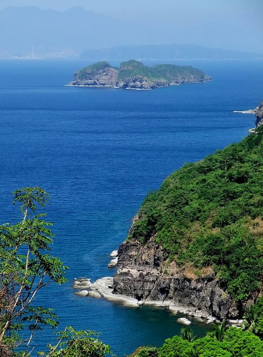
The view from Limbones Island as you look north across Manila Bay.


Islands of the Manila Bay US Military Reservation
The military purpose of Limbones Island was to provide ‘eyes’ 3.9 km/2.4 miles further out into the mouth of Manila Bay from Fort Frank. It had two tertiary Fire Control Stations for the 14-inch guns of Batteries Greer and Crofton. A communications cable was laid in the bay to provide direct voice contact between the Fire Control Stations and the batteries.
Limbones Island was never fortified and no one was stationed there permanently. Structures built included two concrete Fire Control Stations, a troop shelter, concrete steps from the beach up to the top of the cliffs, a concrete landing and a communications cable terminal.

Sketch made from a 1920 map of Limbones Island. (Courtesy Glen Williford)

Sketch of the two Fire Control Stations as they would have appeared in 1922. They should be simple rectangular concrete structures with a pedestal on the floor for mounting the Depression Range Finders. (Courtesy Glen Williford)
As far as I can determine, Limbones Island was not manned during WWII by either side. On January 5th 1945, B-24 Liberators escorted by P-40s bombed the island but I cannot find the reason for this attack. There is little information available about Limbones Island and it is rarely visited today.
In February of this year, Karl and I along with a group of CDSG members made everyone’s first trip to Limbones Island. We had come all the way from Corregidor and it was an expensive boat ride. Due to time limitations and some people not prepared for the dense vegetation, we turned back approximately 200 metres before reaching our goal of finding the Fire Control Stations. The trip was valuable though as it was great preparation for a subsequent trip. When the next time comes, we know where to land on the island, how to get up the cliff and in what direction to head when searching for the stations.

Google Earth satellite photo of Limbones Island taken in 2010. The island does not look overgrown in this view but it sure is when you are standing on it.

The island is nearly all cliffs and we only know of one easy way up…the old concrete steps. Our February hike started at the top right corner of the photo and my GPS track that day showed we made it almost 2/3 of the way there before abandoning the trip. The two Fire Control Stations are located on the bottom middle ‘arrow head’ shaped point.

The profile of Limbones Island.
Here are some photos from the February trip:

A view of the southern end of the island as we approach Limbones.

The northern end of the island. A small house is visible above the cliffs.

The boat will drop us off here.

A closer view of the above photo showing remnants of a concrete landing, cable hut and steps up to the top of the island.

A wooden gangplank made for easy access to Limbones this day. This type of boat is not well suited for rocky coastlines, usually you get wet to the crotch getting ashore plus you have waves and slippery rocks to deal with. Factor balancing your gear into the mix and getting on and off some islands can be interesting.

Walking up the stone and concrete steps. The rectangular structure to the right is the Cable Terminal where the communications cable came ashore from Fort Frank.

Close-up view of the Cable Terminal and two conduits going into the water.

There is not much to see inside the Cable Terminal itself.

Looking back towards the boat. Bataan can be seen across Manila Bay.

The upper half of the concrete steps to the top of the island.

This is the same little house that we saw earlier from the boat.

It appears that no one has lived here for some time.
Heading inland towards the point where the Fire Control Stations are located, we passed a structure shown on the map as a Troop Shelter. The location is about correct for the shelter but this does not appear to be a 1920s era building. Obviously the new metal roof is not original.

Troop Shelter?

Interior view, note the new roof. There are no dates or other markings in the concrete walls to indicate their age.
The march from here to further inland was slow and as I mentioned earlier, it was decided to return to the boat before reaching our goal.
Preparation for a second trip to Limbones Island.
Last month Karl and I were on a three day WWII history tour. He drove and I tried not to get us lost. One “To Do” item of that trip was to drive to Santa Mercedes which is the nearest small village close to Limbones Island. There we wanted to find a man with a boat willing to take us to the island. We found him and the price was good so we exchanged contact information. Since Fort Frank is nearby we also added that to the itinerary.

Santa Mercedes is by far the most direct route for us to get to Limbones Island.
Soon the rainy season would be over and we could get serious about this trip. When a few good days in a row looked likely, we would go. Well, that time came last week. The nearest home base for us with accomodations would be Nasugbu, Batangas which is less than a one hour ride from Santa Mercedes. Nasugbu also has WWII history in that it was the location of the 1945 amphibious beach landing of the 11th Airborne Division in preparation for their drive north to help retake Manila.

Late afternoon view of Nasugbu, Batangas
Trip #2 to Limbones Island
Early last Friday morning, November 23rd, we drove to Santa Mercedes. It is a small coastal fishing village with only one partially paved road connecting it to anywhere. I get the impression that during the worst of the rainy season, by boat would provide their only outside contact. This will change soon though as a new modern two-lane road is being built in the area. The people are very nice and don’t seem to mind a couple strangers paying them a visit.

The road to Santa Mercedes is mostly good to very good but the last stretch is rough. This rock bridge is close to the village.

The village itself is at the mouth of a small river where a ravine reaches the coast.

Santa Mercedes in the distance.

Downtown Santa Mercedes.

Another view of Main Street.

Hazy early morning view looking inland.

A view of the beach.

On a point not far from Santa Mercedes we have a good view of Carabao Island (Fort Frank). Directly above Carabao you can see Topside on Corregidor through the haze. Mount Mariveles, Bataan is behind Corregidor.
The plan for today was a boat trip to both Limbones Island and Carabao Island (Fort Frank). We would allow seven hours total for both places. For some reason that I never understood, the boat departed and headed for Carabao Island. At the time it did not seem important but after spending four hours on Carabao and then travelling to Limbones, the waves were too dangerous for a safe landing. We took a good look but aborted due to concerns about the boat plus our own skins and equipment. Just four metres from the shore we decided to return to Santa Mercedes.
The seas were definitely calmer in the morning and we may have had no problem to get onto Limbones if we had gone there first. A local guy who accompanied us said mornings are better for Limbones but unfortunately this day we started in the opposite direction. Both Karl and I have been to Fort Frank several times before so that was not a priority. Although disappointing, it was the correct decision considering the crashing waves on the rocky shore.
Unfortunately this Limbones Island trip report is incomplete in that actual photos of the two small Fire Control Stations are missing. Due to the effort and expense of making a third trip to the island I may not even bother. At the moment I do not know of any other sites in the area to include in another three day trip which would justify returning. We have been told that March is a good month to go as the winds are generally light. Karl seems interested but I will decide at the time. Corregidor will always be my preferred destination, I never get tired of that place.

The view from Limbones Island as you look north across Manila Bay.


