


Post by Karl Welteke on Jan 21, 2016 17:31:21 GMT 8
AERIAL SHOTS OF FORT MILLS RADIO AND NCO BARRACKS (AROUND 1930), TOPSIDE ON CORREGIDOR ISLAND AND THE CROCKETT RAVINE AREA.
These 2 high resolution images was given to me by Karl Schmidt from the Coastal Defense Study Group (CDSG.org) who got the images from NARA.
The original images where cropped and all images were snipped (Window tool) which is like taking a screen shot of the original images and you get a greatly reduced byte count but the picture still looks the same. None of the pictures in the Flickr album were reduced in size. So, it is like I zoomed in on the snipped copies.
This series of 13 shots are numbered J1a to J13 and are placed in this Flickr album in alphabetical order.
www.flickr.com/photos/44567569@N00/sets/72157658661455655
The same 13 images are presented here in the forum but are smaller:
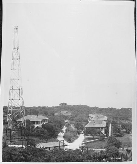
W585 (J1) a prewar image of the Fort Mills Radio and NCO barracks area, Topside on Corregidor, pre WWII. This picture was provided by Karl Schmidt of the Coastal Defense Study Group (cdsg.org) who got it from the National Archives and Records Administration (NARA).
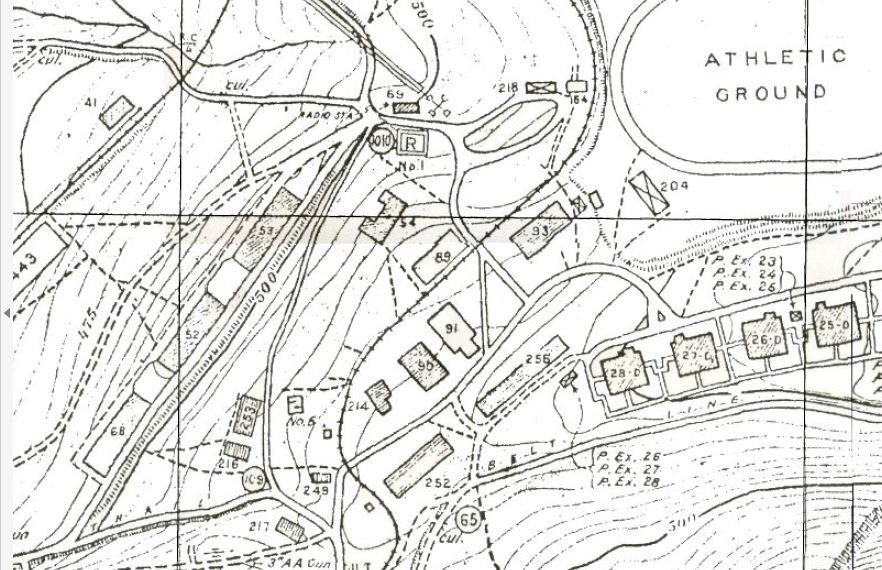
W586 (J2) map of the Fort Mills Radio and NCO barracks area Topside on Corregidor, pre WWII.
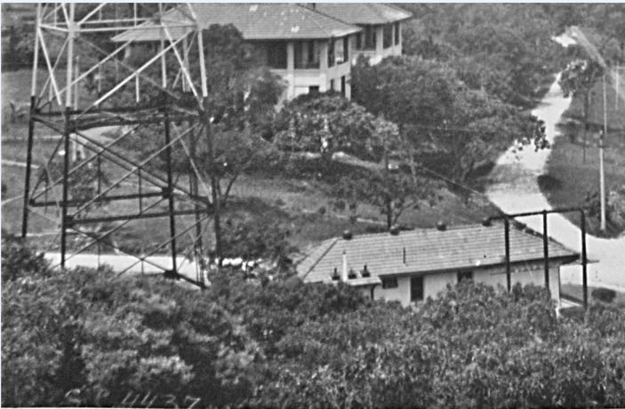
W587 (J3) close-up of the Fort Mills Radio and NCO #54 barracks, Topside on Corregidor, pre WWII. This picture was provided by Karl Schmidt of the Coastal Defense Study Group (cdsg.org) who got it from the National Archives and Records Administration (NARA).
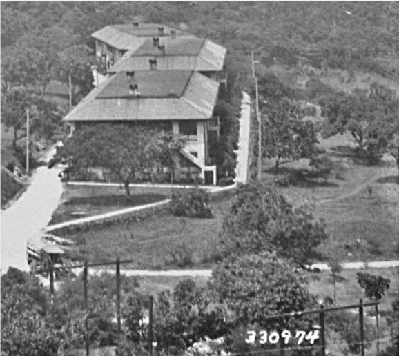
W588 (J4) close-up of the Fort Mills row of three NCO barracks, Topside on Corregidor, pre WWII. This picture was provided by Karl Schmidt of the Coastal Defense Study Group (cdsg.org) who got it from the National Archives and Records Administration (NARA).
W589 (J5) close-up of the Fort Mills #54 NCO barracks, Topside on Corregidor, pre WWII. This picture was provided by Karl Schmidt of the Coastal Defense Study Group (cdsg.org) who got it from the National Archives and Records Administration (NARA).
W590 (J6) close-up of the Fort Mills #253 and 216 NCO barracks, Topside on Corregidor, pre WWII. This picture was provided by Karl Schmidt of the Coastal Defense Study Group (cdsg.org) who got it from the National Archives and Records Administration (NARA).
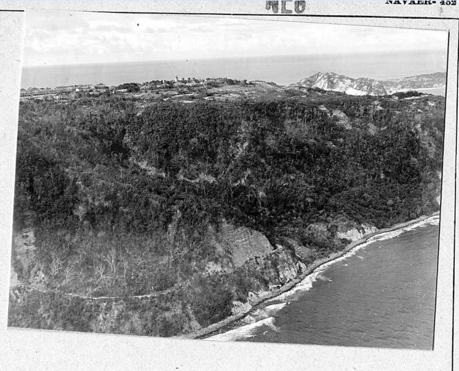
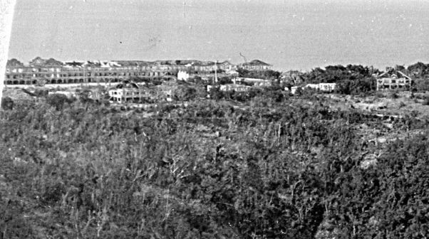
W591 (J7) an image, just prior to the assault on Corregidor, perhaps 1944 or 1945 (Fort Mills), of the general Crocket Ravine area. This picture was provided by Karl Schmidt of the Coastal Defense Study Group (cdsg.org) who got it from the National Archives and Records Administration (NARA).
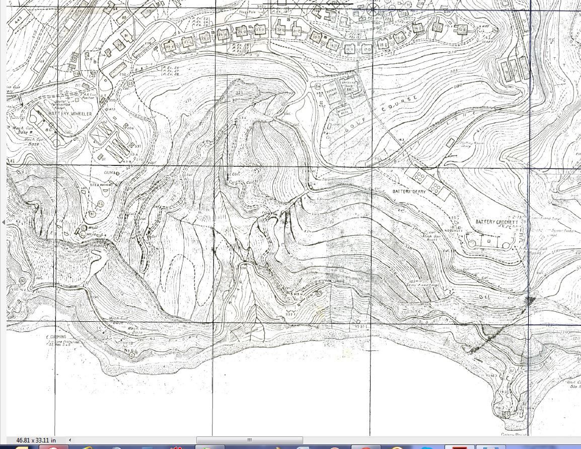
W592 (J8) section of a 1936 Fort Mills map, on Corregidor of the general Crocket Ravine area.
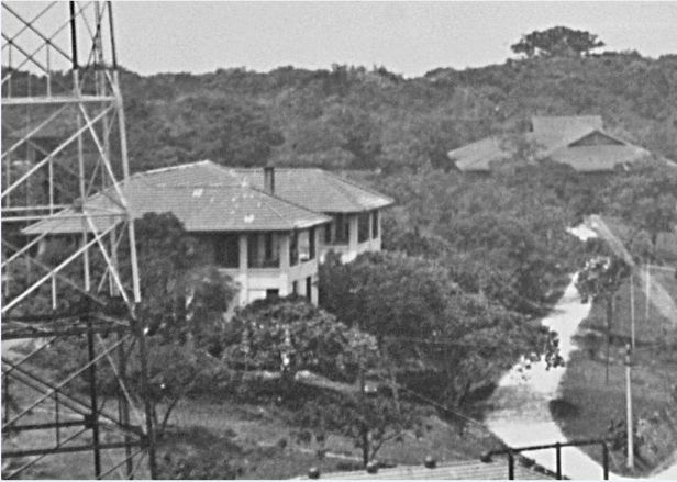
W593 (J9) close up of some of the Fort Mills Senior Officer Quarters, Topside on Corregidor. This picture was provided by Karl Schmidt of the Coastal Defense Study Group (cdsg.org) who got it from the National Archives and Records Administration (NARA).
W594 (J10) close-up of some of the Fort Mills Senior Officer Quarters and the golf course, Topside on Corregidor. This picture was provided by Karl Schmidt of the Coastal Defense Study Group (cdsg.org) who got it from the National Archives and Records Administration (NARA).
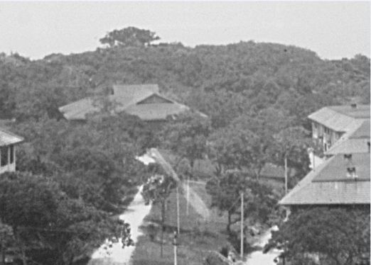
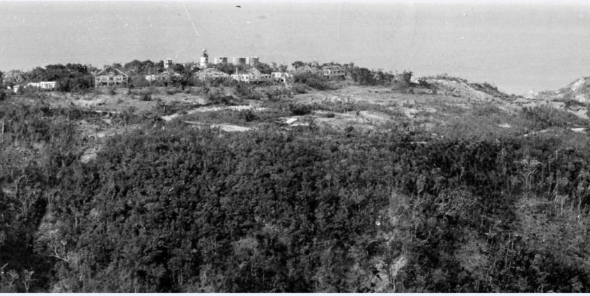
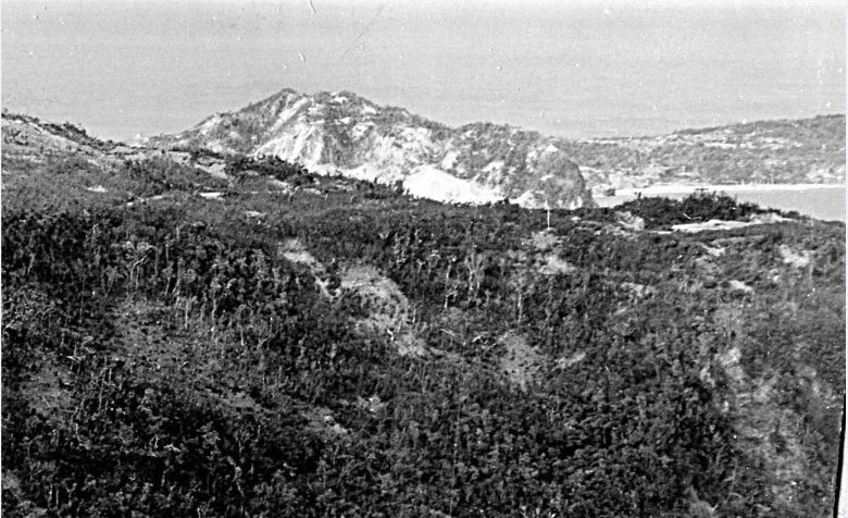
W595 (J11) this is a full view of the Crockett Ravine, Fort Mills on Corregidor Island. This picture was provided by Karl Schmidt of the Coastal Defense Study Group (cdsg.org) who got it from the National Archives and Records Administration (NARA).
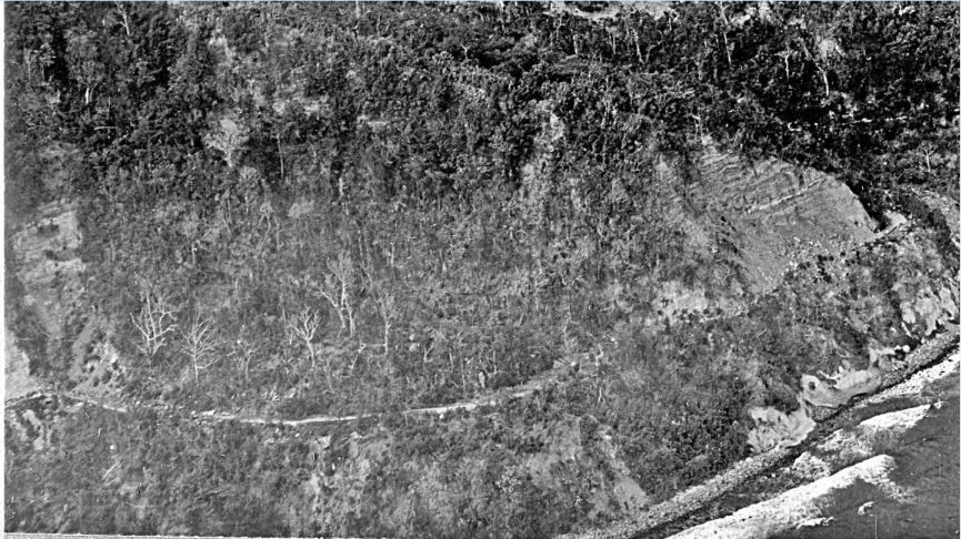
W596 (J12) close-up the South Shore Road coming out of the Crockett Ravine, Fort Mills on Corregidor Island. The road continuous to the left, towards Search Light Point. At the extreme left, I think, I see Search Light #6. This picture was provided by Karl Schmidt of the Coastal Defense Study Group (cdsg.org) who got it from the National Archives and Records Administration (NARA).
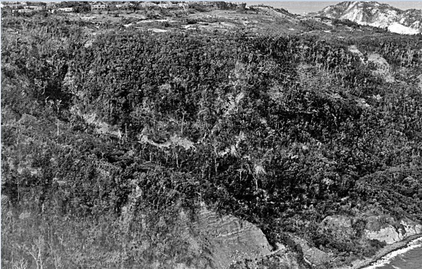
W597 (J13) close-up of the area left of Battery Crocket, Fort Mills on Corregidor Island which is at the right of this image. This picture was provided by Karl Schmidt of the Coastal Defense Study Group (cdsg.org) who got it from the National Archives and Records Administration (NARA).
These 2 high resolution images was given to me by Karl Schmidt from the Coastal Defense Study Group (CDSG.org) who got the images from NARA.
The original images where cropped and all images were snipped (Window tool) which is like taking a screen shot of the original images and you get a greatly reduced byte count but the picture still looks the same. None of the pictures in the Flickr album were reduced in size. So, it is like I zoomed in on the snipped copies.
This series of 13 shots are numbered J1a to J13 and are placed in this Flickr album in alphabetical order.
www.flickr.com/photos/44567569@N00/sets/72157658661455655
The same 13 images are presented here in the forum but are smaller:

W585 (J1) a prewar image of the Fort Mills Radio and NCO barracks area, Topside on Corregidor, pre WWII. This picture was provided by Karl Schmidt of the Coastal Defense Study Group (cdsg.org) who got it from the National Archives and Records Administration (NARA).

W586 (J2) map of the Fort Mills Radio and NCO barracks area Topside on Corregidor, pre WWII.

W587 (J3) close-up of the Fort Mills Radio and NCO #54 barracks, Topside on Corregidor, pre WWII. This picture was provided by Karl Schmidt of the Coastal Defense Study Group (cdsg.org) who got it from the National Archives and Records Administration (NARA).

W588 (J4) close-up of the Fort Mills row of three NCO barracks, Topside on Corregidor, pre WWII. This picture was provided by Karl Schmidt of the Coastal Defense Study Group (cdsg.org) who got it from the National Archives and Records Administration (NARA).

W589 (J5) close-up of the Fort Mills #54 NCO barracks, Topside on Corregidor, pre WWII. This picture was provided by Karl Schmidt of the Coastal Defense Study Group (cdsg.org) who got it from the National Archives and Records Administration (NARA).

W590 (J6) close-up of the Fort Mills #253 and 216 NCO barracks, Topside on Corregidor, pre WWII. This picture was provided by Karl Schmidt of the Coastal Defense Study Group (cdsg.org) who got it from the National Archives and Records Administration (NARA).

W591 (J7) an image, just prior to the assault on Corregidor, perhaps 1944 or 1945 (Fort Mills), of the general Crocket Ravine area. This picture was provided by Karl Schmidt of the Coastal Defense Study Group (cdsg.org) who got it from the National Archives and Records Administration (NARA).

W592 (J8) section of a 1936 Fort Mills map, on Corregidor of the general Crocket Ravine area.

W593 (J9) close up of some of the Fort Mills Senior Officer Quarters, Topside on Corregidor. This picture was provided by Karl Schmidt of the Coastal Defense Study Group (cdsg.org) who got it from the National Archives and Records Administration (NARA).

W594 (J10) close-up of some of the Fort Mills Senior Officer Quarters and the golf course, Topside on Corregidor. This picture was provided by Karl Schmidt of the Coastal Defense Study Group (cdsg.org) who got it from the National Archives and Records Administration (NARA).

W595 (J11) this is a full view of the Crockett Ravine, Fort Mills on Corregidor Island. This picture was provided by Karl Schmidt of the Coastal Defense Study Group (cdsg.org) who got it from the National Archives and Records Administration (NARA).

W596 (J12) close-up the South Shore Road coming out of the Crockett Ravine, Fort Mills on Corregidor Island. The road continuous to the left, towards Search Light Point. At the extreme left, I think, I see Search Light #6. This picture was provided by Karl Schmidt of the Coastal Defense Study Group (cdsg.org) who got it from the National Archives and Records Administration (NARA).

W597 (J13) close-up of the area left of Battery Crocket, Fort Mills on Corregidor Island which is at the right of this image. This picture was provided by Karl Schmidt of the Coastal Defense Study Group (cdsg.org) who got it from the National Archives and Records Administration (NARA).


