|
|
Post by EXO on Jul 7, 2008 21:47:58 GMT 8
Does anyone know the exact Datum Point for Corregidor?
|
|
|
|
Post by fots2 on Jul 11, 2008 10:19:41 GMT 8
Paul Is this what you are looking for? Here is a link to GPS co-ordinates for 10 locations on Corregidor. www.waypoints.ph/index.htmlType 'Corregidor' in the search box to see the locations. Click the 'Waypoint Data ' icon for each location to see the co-ordinates. John |
|
|
|
Post by Paul on Jul 13, 2008 22:55:06 GMT 8
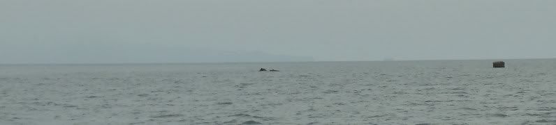
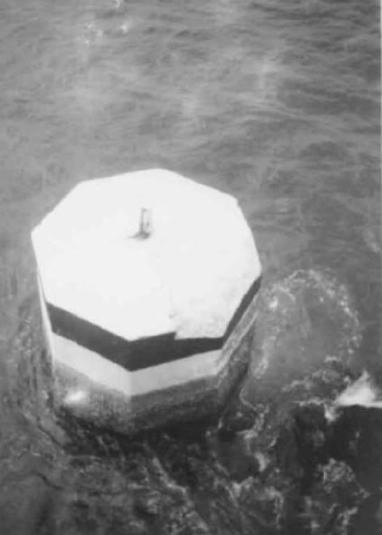
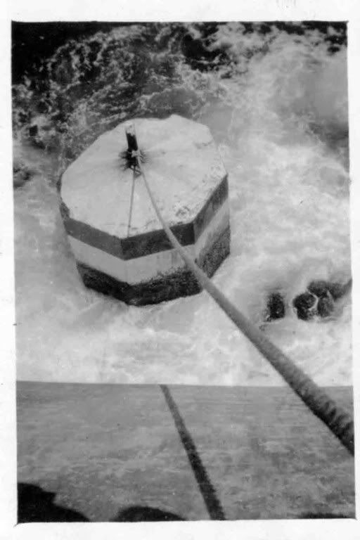
The Datum Point was the point from which artillery bearings and distances were calculated, and as Tony Feredo just reminded me, this point could even be under water - the Datum Point for Ft. Drum, for instance, is a cement block marker immediately to the east of Drum's "bow."
Thanks for finding that link - I had not realised that there is now a GPS Station BTN2 on the island at the site of the Lighthouse. I guess that those other points were just readings made by someone with a hand-held receiver.
exo
|
|
|
|
Post by fots2 on Jul 14, 2008 8:22:02 GMT 8
Station Name: BTN-2 Location: Topside, Corregidor Island Date Established: 2/17/1991 WGS84 Latitude: 14deg 22' 46.74622" WGS84 Longitude: 120deg 34' 35.41566" PRS92 Latitude: 14deg 22' 52.14724" PRS92 Longitude: 120deg 34' 30.50102" Fixing Method: Traversing Responsible Authority: NAMRIA www.namria.gov.ph/namria/prs92/website/home.asp |
|
|
|
Post by fots2 on Jul 17, 2008 1:00:37 GMT 8
BTN-2 Location:
From Pier 15 at the South Harbor, ride on a Coast Guard Sea Craft and head SW towards Corregidor Island for 2 hrs. There are 2 piers on the island, on the N side and the other pier is on the S ìside.
Upon unloading at the pier, travel W by motor vehicle going upward to Brgy. Topside, where the Vehicle Traffic Scheme (VTS) structure and the Corregidor Lighthouse are located.
Station was established on the NW corner of the overhanging flooring of the 5th floor of the VTS structure. It is about 13 m. high from the ground surface. A drilled hole 1 cm. wide and 1 cm. ìdeep, centered in a 30 cm. x 30 cm. square cement putty, and inscribed "BTN-2, 1991, NAMRIA". WGS84 COORDINATES: N 14 22 46.74622 E 120 34 35.41566 ELLIPSOIDAL HT. : 238.9611 m.
|
|
|
|
Post by Karl Welteke on Jun 29, 2012 16:09:21 GMT 8
|
|
|
|
Post by fots2 on Jun 29, 2012 16:40:34 GMT 8
Hi Karl, Regarding Fort Hughes, I think you have it correct. As we passed the island that day I remember you taking those photos. The attached map confirms that the Datun Poiint is offshore. 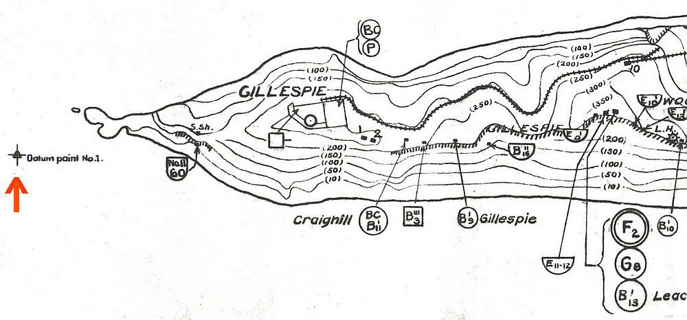 |
|
|
|
Post by fireball on Jun 30, 2012 4:56:35 GMT 8
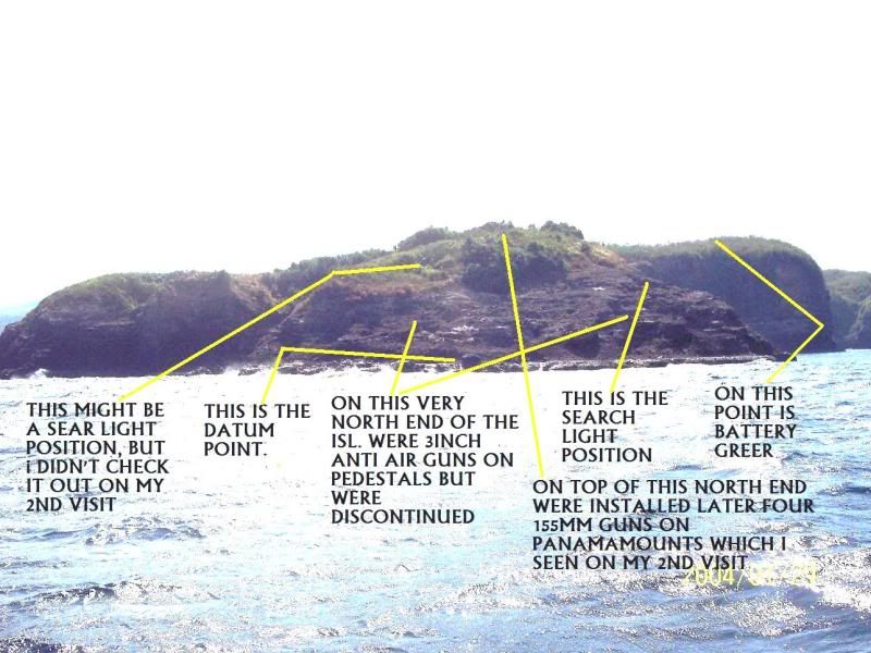
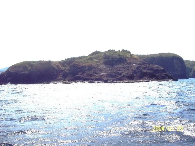
Fort Frank: Another view of the datum. The pic shows another 'thing' which I did not check but which I assumed was a survey point, but might just be an odd shaped rock (or just something else). On Karl's annotated pic of Fort Frank, yes the indent on the left is where the second searchlight shelter is located. Attachments:
|
|
|
|
Post by Karl Welteke on Jun 30, 2012 9:09:17 GMT 8
Fireball, did you go inside that left or eastern search light shelter, did you take pictures, is it similar as the right one and how did you get to that north end of the island.?
This Karl-Wilhelm went there with the only other Karl-Wilhelm (CDSG member) I know of in the whole wide world.
|
|
|
|
Post by fireball on Jul 1, 2012 5:16:37 GMT 8
Hi Karl, See pic for inside of the shelter - the access road / gully was quite overgrown and the shelter was smaller. It generally seemed to be a more basic construction than its partner to the right. From the pic you will see that there is a lot of soil spilling-in from 'bays' on both rear and lefthand side. Not sure if they were actual features of the construction which had subsequently been dug out or just a result of the search for rebar. Access to the north end was via the far end of Battery Greer - probably the same way you got there. The path is apparent but overgrown so requiring a bit of hard work for the first 50meters. A warning, there are a couple of drops to service ducts one of which I passed within about a foot of before seeing. Attachments:
|
|