|
|
Post by EXO on Jun 7, 2019 7:52:04 GMT 8
I am posting some recent images here which I have received from some of our friends, because I prefer to share them with all for comment. I encourage comments. The initial posting is from Mike Ross, who cc'd me in to some correspondence. This is what he had to say: |
|
|
|
Post by EXO on Jun 7, 2019 7:55:58 GMT 8
The mosaic image from 1962 is most interesting. I must admit to being quite supportive of Mike's idea that (in an ideal world) the trail around Kindley field would be a good thing to reopen. Its present overgrown state adds nothing to the island, and there's a great many things to be seen through that area.
|
|
|
|
Post by EXO on Jun 7, 2019 8:01:42 GMT 8
The second posting this morning are three images by Jerry R, who came upon the scene during one of his recent walks near the Hospital. This is an easy one for many of you. 
|
|
|
|
Post by EXO on Jun 7, 2019 8:16:27 GMT 8
Jerry R also did a walk around Battery Way: Comments are invited. "I had a good walk around the hill above Battery Way. Got ripped by the undergrowth bit stumbled on one of what I believe is an old radio mast and a quite large bunker system with tunnel. I tried to walk north along the Way trail to the ranges but the going was too difficult so I turned back." |
|
|
|
Post by fots2 on Jun 7, 2019 12:35:13 GMT 8
Reply to the first post. 1. The road sections labeled in yellow still exist but are all overgrown. Effort would be required to clear the road but it is doable. Starting at Kindley Field and travelling counter-clockwise, the section along the airstrip has small trees, bushes and grasses. Moving towards the hairpin turn at the eastern end of the road you see some larger trees but still lots of bushes and grass. There is a concrete rifle butt (i.e. defensive wall) to the right before the turn. In the area of the turn itself is one of the old cemeteries with some Spanish text on headstones. After the turn there are some larger trees for awhile and the road is covered with high grass. Nearing the airstrip, the trees become smaller and there is mostly large bushes and high thick grasses. Past the airstrip heading west we come to large trees again. Although the road is grassy and has lots of fallen branches etc, the road is often walkable. Along here, the two balloon hangars and Denver Tunnel can be visited. This road rejoins the main road at the Philippine Heroes Memorial. The overall terrain is generally flat and still has culverts as it was a vehicle road. This would be ideal for hiking and bicycles. Two other roads north of the airstrip which intersect the one in question could also be cleared. They take you to interesting locations along the north shore of the island.
2. The south side of Malinta Hill is a huge mass of fractured rock. The South Shore Road could be cleared but you can never guarantee that more rock will not fall at any moment making it a dangerous road to use. 3. The horses were brought to Corregidor and available for rides at the south part of Bottomside. They were never popular and eventually moved to Kindley Field where they actually became a bit wild. They would try to bite people who approached them. Fortunately they were removed from the island. 4. The Spanish cistern is still there beside the lighthouse. It is original as far as I know. That photo is from a book which is labeled below. 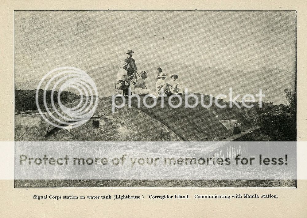 |
|
|
|
Post by fots2 on Jun 7, 2019 12:41:51 GMT 8
Reply to the second post.
This is what the Inn's guides call the "Duck Walk Tunnel" due to the fact you have to bend over in it. The location is between Battery Way and the post hospital close to where the dual trolley line passed by.
This concrete "tunnel" looks impressive but is actually just underground drainage. It is unique due to the graffiti on the walls.
|
|
|
|
Post by fots2 on Jun 7, 2019 12:50:00 GMT 8
Reply to the third post. 1. The photo of the concrete doorway going underground is shown on maps as Site "B". This doorway is one of two entrances to an underground magazine for one of the four original anti-aircraft guns (dated 1917). The gun block is approximately 15 or so meters from there but difficult to see as it is overgrown. This link will show you photos of the place. Site "B"2. The two level bunkers are battery control stations for mortar batteries Way and Geary. This area can be quite thick and thorny. 3. The "old radio mast" you saw up there was exactly that. It is one of about ten of them that ran in mostly a straight line along the ridge from Radio #2 towards the north shore of the island. FYI, Radio #2 is the structure adjacent to Battery Way. From the mortars, walk towards the toilets, go past them and you will see a concrete staircase down to it. |
|
|
|
Post by chadhill on Jun 8, 2019 10:56:59 GMT 8
Ok, here are some more from me. What's exploding, where and when?  Again, what's burning or exploding, where and when?  Where's this, what happened and when?  The winner gets one of these, compliments of the "New and Improved" CFI, Sun Cruises, and the Cabcaben Village Boat COOP.  P.S.- Hope I know all the answers...  |
|
|
|
Post by fots2 on Jun 8, 2019 12:59:44 GMT 8
Hello Chad, Psssst….did you forget to remove the photo labels?  You have been busy collecting photos. Nice job! 1. My guess is that this is the explosion of the magazine between gun #1 and gun #2 at Battery Ramsay. I have never read the exact date this happened in early 1945 but hopefully someone can answer that for us. 2. I am not sure what this explosion was. It is in the direction of Battery Cheney but that battery is intact. There are many craters in the area but I have no idea what such a large explosion would be. Any ideas? 3. Now this one is easy. (rotate the photo left). This is the 12-inch mortar which was blown inside the left-hand magazine when Battery Geary exploded. It now partially holds up the roof. Another mortar holds up the outer edge of this same roof. A photo of the opposite end of the mortar in your photo is below. 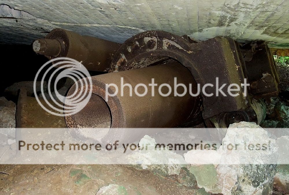 Great photos Chad. Thanks. |
|
|
|
Post by chadhill on Jun 9, 2019 2:35:39 GMT 8
It didn't take you very long, fots! Photo 1: Believe it or not, some guy on Facebook (who will remain anonymous) captioned this pic as being taken by the Japanese during the 1942 Battery Geary magazine explosion. Yes, I'm with you that it's the Battery Ramsay magazine, sometime in an early '45 bombing raid, but I don't know the exact date. Photo 2: This pic, not captioned, has baffled me for a long time. A much better reproduction of it can be found in "Rock Force" by Whitman and Metherell. Flanagan's book has a poor quality photo of a similar, though lesser rising, vertical smoke cloud, but I am not sure of the location. I agree that the vertical smoke in photo 2 seems to be in the Battery Cheney area, maybe near the top of Cheney Ravine. Recently I read that the Japanese had a storage tunnel or cave in this area. But dangit, I failed to bookmark it and have spent two hours today trying to find that source, with no luck.  Photo 3 was captioned "Battery Geary 1945", but I don't recall where I found it. It had been posted as shown, and at first I was puzzled by the sunlight being at the top. But you quickly noticed that the pic needed to be rotated 90 degrees left, good job. |
|


