|
|
Post by Registrar on Sept 29, 2008 22:26:57 GMT 8
|
|
|
|
Post by mapmaster on Oct 5, 2008 6:50:58 GMT 8
Hi All
A look at the original maps of Corregidor and other period photographs would suggest this station to be on Topside. There was a station in the north east corner of the parade ground, in front of Mile Long Barracks and across the road from the Cinema. To suggest this, there is only one place where there was a road, crossing a single track and with a station at its intersection.
The track work here is in a shallow cutting. The photograph confirms this.
Regards
mapmaster
|
|
|
|
Post by The Phantom on Oct 5, 2008 7:59:08 GMT 8
I agree that this is the station on Topside.
The trolley track bed shown in the picture exists today heading east and west. Going west it leads past the Parade Grounds on one side and the Mile Long Barracks on the other side as stated, and also goes east, past the Cinema in the other direction.....
To where?
Some of the old wooden railroad ties can still be seen in the road bed next to the Cinema.
Some old ties and spikes still exist all over the island. Some along roads or deep in the jungle.
All the steel rails were long ago taken to Japan for the war effort.
Bethlehem Steel rails ?
Who had to pull up all those steel rails for the Japanese, take them to the docks, and load them up on ships?
|
|
|
|
Post by mapmaster on Oct 5, 2008 9:24:53 GMT 8
Hi Phantom I've missed seeing the tramway formation (bed) by looking in the opposite direction during visits. It is interesting that portions of the tramway formation and relics are still visible. I cannot answer your all your return questions, but I can show where the line went, east of the subject station. It went to the golf club house and swimming pool via the Quartermaster's Storehouses. The station is numbered 88 on the attached map portion; the QM Storehouses are marked 75 to 78; and the golf club house is numbered 551. The track is marked in the same manner as on all maps.  The image is from the '35 map I'm digitising. I'm about half way through the project. Regards mapmaster |
|
|
|
Post by The Phantom on Oct 5, 2008 22:37:13 GMT 8
Your map ties things together well.
I have been to the Quartermasters warehouses from the road leading to all the Officers Quarters still buried in the jungle, south of the monument.
I have been to the Swimming pool from the main road going south.
On this next trip I would like to follow the tracks through the jungle from the warehouses to the pool.
On my last trip to that vicinity, the pool area, I found a golf ball and a very rusted golf club head, a wedge I believe.
I have seen some foundations in the jungle there, south of the pool, but it is a very thick jungle area where the golf course used to be.
There is also a very interesting small prepared concrete gun position at the turn in the road below the pool. It covers the road coming up or going down.
You can't see it unless you work a little. I have found after discovering this (Machine gun pit)? that almost every turn in the road has a prepared position or one that was hastily put together.
The picture of the trolley station on Topside is a gem, it really helps tie things together, past to present, as the scenery has changed so much on Corregidor from the prewar years.
|
|
|
|
Post by Buster on Oct 6, 2008 7:21:43 GMT 8
Another view 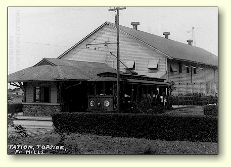 |
|
|
|
Post by mapmaster on Oct 6, 2008 8:10:15 GMT 8
Hi
Another view - another great photograph.
This shows the privately owned building #92 on the edge of the parade ground/sports ground. Originally, there was also a grandstand # 154 on the other side on the first building; perhaps still there when this photo was taken.
These buildings #92 and #154 were marked on the 1921 Corregidor map, but not on the 1932 or later maps. That fact gives some indication of the date of photography for these two photos.
Regards
mapmaster
|
|
|
|
Post by mapmaster on Jan 16, 2009 8:30:29 GMT 8
Corregidor Island - Friday 16th January, 2009Hi Here is a photo of the site and remains of the Topside Station taken two days ago. I've matched the camera position and direction as close as possible.  mapmaster
|
|
Deleted
Deleted Member
Posts: 0
|
Post by Deleted on Apr 25, 2010 8:58:56 GMT 8
As a dependent on Corregidor from 1939-41, I remember riding the trolley from Topside down to the barrio on Bottomside. Us kids used to troop all over the island, as parents knew we couldn't get too lost.
Standing at attention wherever you were when the flag was lowered. During rainy season, I was allowed to play outside with my swimsuit on. I think the Cine was a dime...or was it a nickel? Ah, memories.
Marvin Kennebeck
|
|
|
|
Post by fots2 on Apr 25, 2010 10:16:01 GMT 8
Hi Jimmy, Corregidor sounds like a unique place to be a kid. Was your family evacuated to the US before the war started? Here is a view on one of the trolley stations you would have passed through. This one is just west of Middleside and is the most intact one still existing. The upper wooden part is long gone. 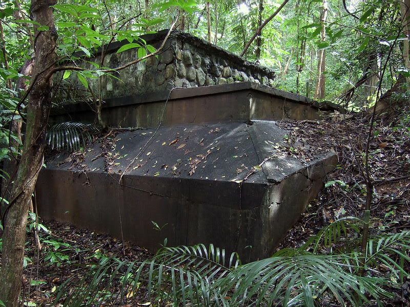 |
|


