|
|
Post by oozlefinch on Jun 19, 2012 11:57:23 GMT 8
Thanx. My last trip was in 2006 with Army Junk and CDSG; however, bronchitis limited my ability to get around. I thought I had seen most everything on my trips in '87 and '89 with Al McGrew, but ya'll keep showing me I barely tipped the iceberg.
|
|
|
|
Post by fots2 on Jun 19, 2012 17:01:02 GMT 8
In February of this year, I was with Armyjunk and CDSG again. You were in good company.
|
|
|
|
Post by beirutvet on May 9, 2015 1:13:22 GMT 8
Hello Oozlfinch GOOD CATCH! You did indeed see something, I am sure, about AA machine gun towers on Morrison Hill, so did I. Sometime last year I started a thread about "Unknown Structures" in Mile Long Barracks. Early on in the thread it was suggested that these structures might have been AA machine gun towers but it is unlikely. Then Armyjunk came up with some documents that proved there were temp AA towers placed on Morrison Hill. Here is a copy of it below, and props to him for finding it. The documents state that the tower was 28' 4". Now it is difficult to say for sure but the angle of the photo of the 3" guns firing look as though they could be of that approximate height. Granted, this does not prove that the photo was indeed Battery Chicago but lends evidence in that it proves that an elevated photo was possible in an otherwise flat piece of terrain. Fots You had mentioned that your map from 1936 did not have the towers on there. Could you check the exact date of your map? As you can see in Armyjunks document that the structure was not completed till Aug 7, 1936. Perhaps it came too late to be included on your map. As for the guns being mobile units, is it possible that for flexibility purposes they were kept on their mobile trailers and were test firing simply where they were more than likely to be fired from? As they would have surmised even in 1936, attacks would be increasingly made from the air and were simply not keeping all there eggs in one basket, so to speak. Mobile units are easily hidden and less susceptible from air attacks as fixed positions. Your thoughts, guys? ![]() 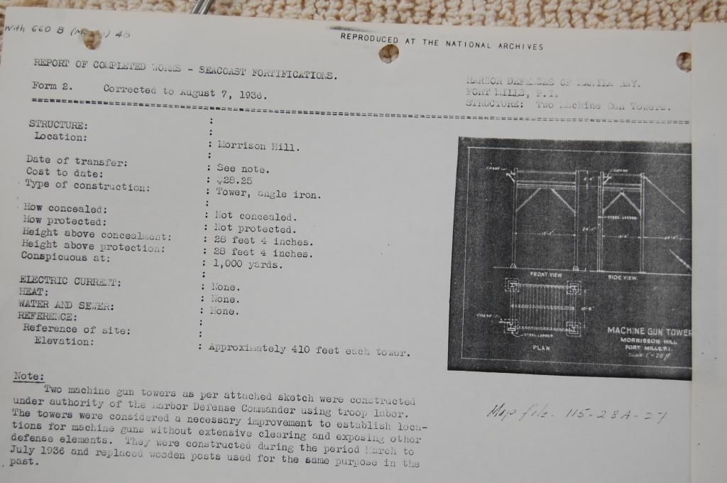 |
|
|
|
Post by fots2 on May 10, 2015 20:54:23 GMT 8
The 1936 map does not show any machine gun towers on Morrison Hill. That map was “revised to include March 31, 1936”. Note Part 2 of this report. It shows sketches of Battery Morrison drawn by a member of the battery while a POW. He shows the four AA guns in prepared positions with embankments surrounding them. They do not appear easily moveable anymore. No information I have read mentions the guns even moving at Battery Chicago during wartime. Here is a link to Part 2. Link |
|
|
|
Post by beirutvet on May 11, 2015 1:48:30 GMT 8
Hey fots2
Your link just brought me back to part 1 so I went and looked for part 2 and you are correct about the protection around each gun making moving in and out near impossible. The POW sketch however, looks like it is the hastily constructed protection of choice on Corregidor, large cans filled with gravel ring around each gun. Do you think this might be just a hastily built enclosure because they are now at war? Could they have been constructed well after this possibly peacetime photo was taken?
I also see what you mean about the road that is not visible, another reason to believe the photo was erroneously labeled as Chicago just because it had 3" guns. It would not be the first time a photo of that era was mistakenly captioned.
Something else I would like your opinion on. In the POW sketch by Sgt Howell they are clearly depicted as squared and slightly staggered. The hand drawn map of Lt Cornwall, also of Battery Chicago notes them as square but offset slightly confirming Sgt Howell's depiction. In the aerial photo and also the map from 1936, the first 4 guns are in a straight line.
2 eyewitness accounts and depictions show Square shape but the map and aerial photo differ greatly. Where do you think the error lies here?
It would be cool to find the concrete footings of the AA tower, however, with no map references and the terrain being as overgrown as it is in the photos, good luck trying to find them.
In the photo, the guns are not squared as in the sketches nor do they appear to be in a straight line (light offset). Could they have been temporarily placed in the unused area just north of the guns and being in the general vicinity of Chicago just captioned as such? If the tower were on the north side of the guns you could just turn around and photo in a 360 degree circle.
So many mysteries! This is what I love about this island.
|
|
|
|
Post by beirutvet on May 11, 2015 1:57:49 GMT 8
Fots2
I stand corrected. In the Sketch of Lt Cornwall there are 2 notations clearly labeled as MG (machine gun?). One is NW of the tunnel built in 42 and the other is just NW of the Height finder.
I realize the going cannot be easy around there but have you seen these locations yourself? Are they ground positions or could one or both be the towers referenced in Armyjunks document?
I think someday we may have to have a look.
|
|
|
|
Post by fots2 on May 11, 2015 2:46:32 GMT 8
Hi beirutvet, The link to Part 2 is now corrected, sorry about that. Thanks to the generosity of the daughter of Battery Chicago’s commander, I have some detailed information at home. Unfortunately I will not be able to access it for some time. I do know that Battery Chicago was constructed before the war started but do not know exactly when. You may be interested to read the Battery Chicago Unit History. It is here: LinkThe four AA gun blocks you see in a straight line were not part of Battery Chicago. They were some of the original pedestal mount gun blocks on the island and pre-date this battery by many years. (constructed in 1920). This was known a Site “D”. By the way, note a 5th AA gun block to the right of #3 and #4. This gun block is even older than the other four. 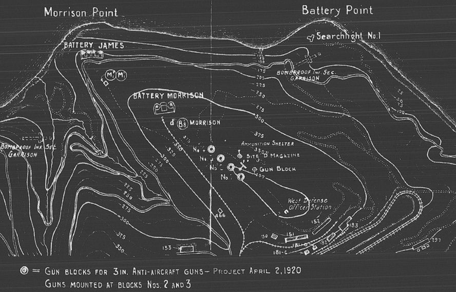 Battery Chicago had mobile 3” AA guns as you know and when it was decided to use Morrison Hill for that new battery, they chose to arrange them in the pattern shown on the sketches. I will have a look for the concrete pedestals of the Machine Gun towers someday. That area is quite thick and overgrown plus has typhoon damage in recent years. That makes even walking difficult. |
|
|
|
Post by fots2 on May 11, 2015 2:50:46 GMT 8
Hi beirutvet,
I just saw your second post.
The two MG positions shown on Lt. Cornwall’s sketch are ground positions. They are still there. Walking is not bad in this area. As you head south along Morrison Hill it gets much worse.
|
|


