|
|
Post by dmether on Aug 5, 2011 18:08:00 GMT 8
A short description of Hospital 1 Attachments:
|
|
|
|
Post by okla on Aug 5, 2011 20:46:36 GMT 8
Hey Dmether....Good stuff. What difficult circumstances those folks performed under. I just don't think they make 'em like that anymore. Many thanks for posting.
|
|
|
|
Post by JohnEakin on Aug 5, 2011 22:01:47 GMT 8
This is part of a report "The official history of General Hospital Number 1" by Col. Duckworth, Commanding Officer Thanks, dmether, that's interesting reading. Any chance you have more of this history on Hospital No. 1? Actually, while copying some text on the location of Hospital No. 2, I found the second excerpt which is mislabeled - it actually pertains to General Hospital No. 2. Here's the location of Hospital No. 2, which was very near Hospital No. 1. ********** We camped on the banks of the Real River which site was to be the location of General Hospital No. 2. A description of this area follows: The area located on the Real River approximately 2 kilometers west of Cabcabin and about the same distance south of the Cabcabin Air field. The real is a good size stream with good swift flow of clear water. It was generally on the north side of the area. National Highway No. 6 was about 1 Km to the south. The soil was a sandy loam and drained well. The area was covered with bamboo or other trees of various kinds, some being very large. Two Small streams flowed into the Real River within the hospital area from the south side. These two small streams were sluggish and muddy areas bordered them in some locations. One headed in the hospital area from a Carabao wallow. The trees, bamboo and vines afforded excellent cover. There was but one bare area near the lower end, which had been a rice patty. There were no roads; one carabao trail, ending blindly, extended into the area from the national highway at Cabcabin, crossing the Real River near the lower end of the area. One foot path crossed the area from the south. Several Filipino houses were located to the north-east of the area. There were open fields to the south, west, north-west and north-east of the area. The hospital area was approximately 2 Km X 1/2 Km in size. ************ This is from the Official History of General Hospital No. 2 which is posted in 3 parts at: bataanmissing.com/wp-includes/files/GenHosp2_History_pt1.pdfbataanmissing.com/wp-includes/files/GenHosp2_History_pt2.pdfbataanmissing.com/wp-includes/files/GenHosp2_History_pt3.pdfUltimately, after Bataan fell, the two hospitals were effectively merged and stayed in business for some time although some of the personnel made the DM and went through O'Donnell. |
|
|
|
Post by dmether on Aug 6, 2011 9:22:43 GMT 8
johneakin, looks like we have the same report on hospital 2, but your's is in better shape than mine, I couldn't scan the whole report as it was in very bad shape and barely held together by tape. Paul Whitman is coming up today, I'll give him my copy of the report on hospital 1 for him to post on this site, he can do a better job than me, I have to crop it down too much to get it to fit.
|
|
|
|
Post by JohnEakin on Aug 6, 2011 10:27:51 GMT 8
Thanks, dmether, I'd appreciate seeing whatever you have on the 1st General Hospital.
Some pages of the roster and history of the 2nd GH that I've posted are very difficult to read. If there are any pages that you are interested in I'll see if there is any way to enhance them. It really is interesting reading and gives a little insight in to the confusion of the time and place.
|
|
|
|
Post by Karl Welteke on Aug 7, 2011 9:36:03 GMT 8
Thanks dmether for making those two items of the two hospitals available. And thanks Johneakin for making the whole report available. I was surprised to read how many buildings were at the site of ‘Little Baguio’. Of course they are all gone but concrete floors, if any, still may be there. But the trouble of finding knowledgeable people is difficult for a foreigner and takes time and other efforts. Here is a thumbnail for the map of the Bataan SE corner, I uploaded it with 1.7 MB but I don’t know how big it will open for you. 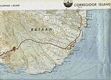 |
|
|
|
Post by fireball on Aug 7, 2011 16:57:15 GMT 8
|
|
|
|
Post by JohnEakin on Aug 9, 2011 7:42:42 GMT 8
Thanks for the reference - Montgomery's manuscript is an interesting read.
All the POW stories are basically the same, but they all have so many details that are different.
|
|
|
|
Post by Karl Welteke on Dec 16, 2015 18:11:59 GMT 8
BEST PICTURE I HAVE SEEN FROM LT EARL REYNOLDS STONE This thread is about Lt. Earl Reynolds Stone whose exact crash site has been positively located by interested and dedicated people but has not been recovered by his country’s Government, the US. His brother, also a WWII veteran, now 95 years and his daughter Elizabeth Stone are still waiting. It is true, the crash site is high on the Mariveles volcano, and to be exact it is on the Tarak Ridge. There is a place where helicopters can land within 400 meters and 200 meter elevation up down on foot to get the crash site from the helicopter landing site. This picture came this way recently via Facebook from Elizabeth Stone. David Metherell shared it. She gave me permission to post it. 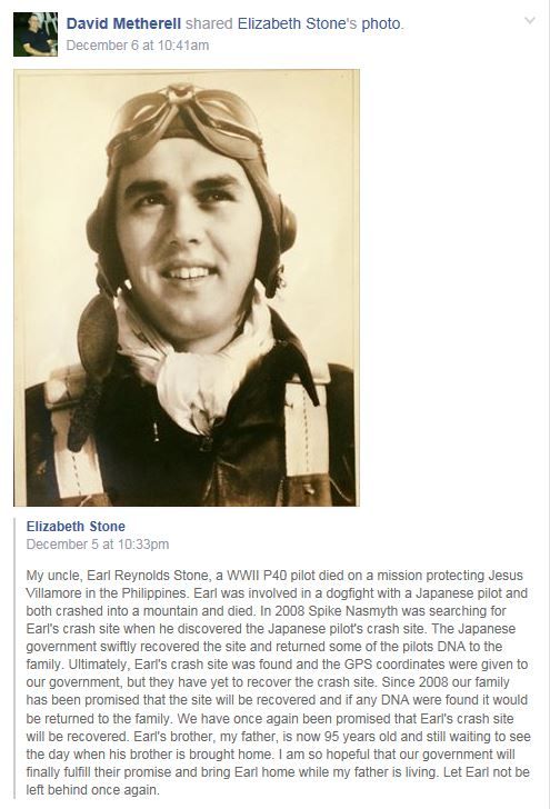 W487 Dave Metherell Facebook page on 6th Dec. 2015 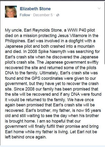 W488 Elizabeth Stone’s comments about her missing uncle Lt. Earl Reynolds Stone. My uncle, Earl Reynolds Stone, a WWII P40 pilot died on a mission protecting Jesus Villamore in the Philippines. Earl was involved in a dogfight with a Japanese pilot and both crashed into a mountain and died. In 2008 Spike Nasmyth was searching for Earl's crash site when he discovered the Japanese pilot's crash site. The Japanese government swiftly recovered the site and returned some of the pilots DNA to the family. Ultimately, Earl's crash site was found and the GPS coordinates were given to our government, but they have yet to recover the crash site. Since 2008 our family has been promised that the site will be recovered and if any DNA were found it would be returned to the family. We have once again been promised that Earl's crash site will be recovered. Earl's brother, my father, is now 95 years old and still waiting to see the day when his brother is brought home. I am so hopeful that our government will finally fulfill their promise and bring Earl home while my father is living. Let Earl not be left behind once again. 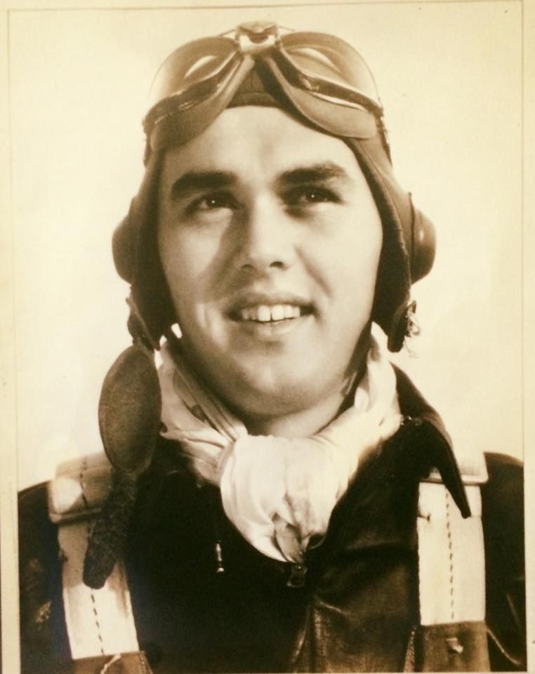 W489 the original size image from the Facebook posting of Lt. Earl Reynolds Stone by his niece Elizabeth Stone. |
|
|
|
Post by Karl Welteke on Dec 16, 2015 20:07:50 GMT 8
BEST DOCUMENTED WEB PAGE ABOUT THE SEARCH FOR THE CRASHED AIRCRAFT OF LT STONE ON THE 9TH FEB 1942 This is the URL: kevinhamdorfphotography.com/new%20images%20feb2008.htmKevin Hamdorf is an Australian photographer living in the greater Subic Bay area and is interested in history. He teamed up with Maj. Spike Nasmyth (USAF Retired) who is also a former POW in Hanoi Hilton; they organized several expeditions to find the crash site of Lt. Earl Reynolds Stone. On this expedition of the 8th to 10th Feb 2008 we failed to find the crash site of Lt. Stone but had a real close look at the crash site of his opponent. I was able to go along and got on a few pictures. Kevin and Spike organized more search trips and eventual found the crash site of Lt. Stone and reported it to the than JPAC Organization. The rumor has it that the ex JPAC may make an effort at in the dry season to find any remains of Lt. Stone. Maybe it is only a rumor, who knows? In the above URL you will see many interesting images about the search effort on this 8th to 10th Feb 2008 trip but all the pictures, including the 3 images presented here are copyrighted and all rights are reserved by Kevin Hamdorf. 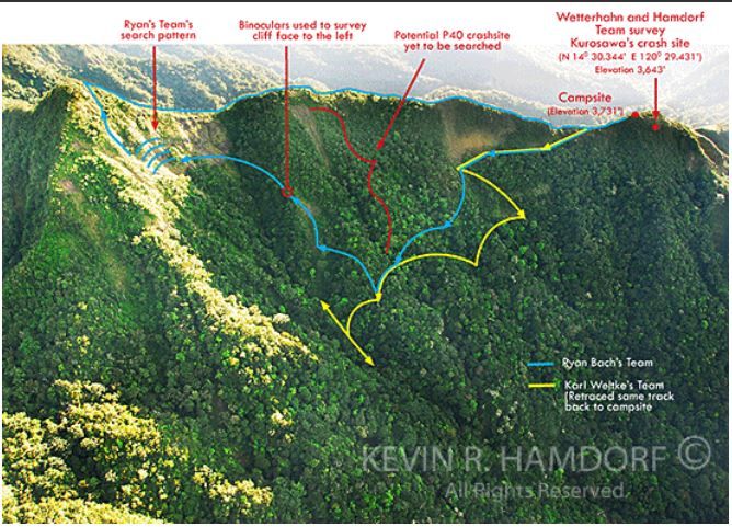 W491 search tracks of the search and Recovery Expedition February 8-10, 2008. Western slope of the Tarak Ridge, Mt. Mariveles, Bataan. Elevation: approx 3,700 feet (Aerial photo taken Jan. 9, 2008 by Kevin Hamdorf). This image is by Kevin Hamdorf and it is copyrighted; you need his written consent.Notice I lead one of those teams on this day. 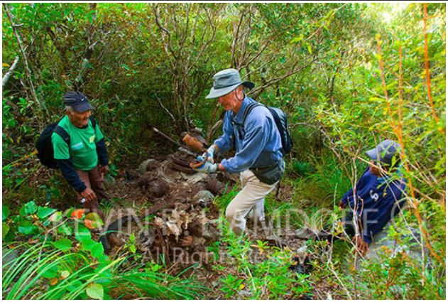 W490 Col. Ralf Wetterhahn (USAF Retired), forensic aircraft crash specialist examines one of the two recovered Type-89 machine guns with Aeta guides Gary Duera (left) and his son Noel (right). In the above URL is more information. This image is by Kevin Hamdorf and it is copyrighted; you need his written consent. The Colonel and I were the same age, 66 years young. 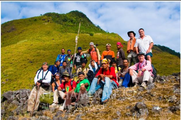 W492 members of the Feb. 8th to 10th 2008 Search and Recovery Team at the helicopter landing pad (elevation approx. 3,350 feet). In the above URL is more information. All the way to the left in a white shirt is me. This image is by Kevin Hamdorf and it is copyrighted; you need his written consent. |
|


