|
|
Post by chadhill on Mar 6, 2011 12:48:38 GMT 8
Fots, I'll bet you're "In like Flynn" ;D. Although the dates don't agree, this must be the same explosion mentioned at the bottom of dmether's map:  "Cavalry Point. Note: 500 cases 60% Dynamite + at least a doz cases {  ?} detonated by shell fire April 29th". Just as a tidbit I'll throw in this Howell book quote on page 67, written by LT COL R.F. Jenkins in 1946: "On Cavalry Point Beach there were the remains of a large store of gasoline. Japanese bombs had destroyed some of the gasoline that had been stored there in 50 gallon drums. We made tank obstacles out of some of these drums...emplacing them on the approaches from the beach". By chance did you run across any of these? |
|
|
|
Post by fots2 on Mar 6, 2011 15:54:45 GMT 8
Hi chadhill,
Yes I would bet it is the same explosion. I can’t explain a few days difference in dates though. All this information came from different people’s memories so errors are certainly possible.
I remember seeing a couple crumpled drums but they were inland closer to the airfield, nothing near the beach that I remember.
|
|
|
|
Post by okla on Mar 7, 2011 0:44:24 GMT 8
Hey Fots....Methinks that you have surely hit upon it. You have scoped the whole area as well as could be done, so this seems to be, as you state, the logical answer. I gotta say that you are about the best at this kind of thing as anyone could be. You continue to fill the void in my lonely days, lol, as well as warding off my ongoing "withdrawal" pangs. Cheers.
|
|
|
|
Post by fots2 on Mar 18, 2012 16:52:04 GMT 8
Here is a minor update that completes this trip report of what remains of all the fortifications constructed north of Kindley Field. One that was not covered in the initial report is I-M-2 (Sector 1, Machine Gun position #2). It is situated above the cliff north of the east end of Kindley Field. Earlier this month I was near Kindley Field so I decided to add I-M-2 to my list of destinations for the day. If I had known how little actually exists now, I might have not fought all the thorns, vines and grasses to get there. The position is nearly totally destroyed. I suspect it being in direct view of Japanese guns on Bataan may have been a factor. There is no way I would have found this without the GPS leading me to the correct spot. The 1936 map shows I-M-2 to consist of one gun position connected to a nearby magazine. Today the magazine is nothing but chunks of broken concrete. A small section of the gun position still exists but by far, it is mostly buried under soil, thick grasses and scrubby trees. The photos do not look like much. 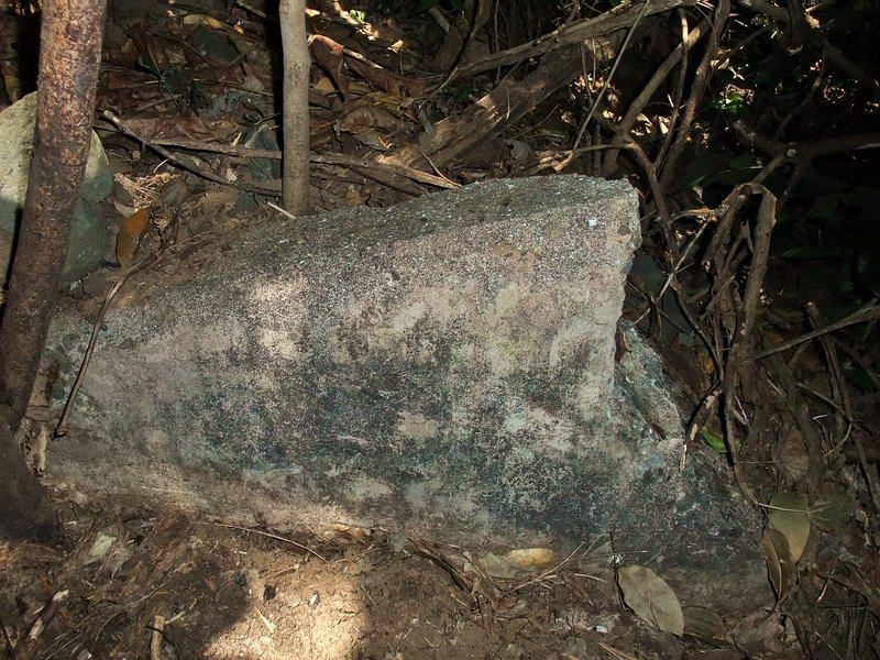 This is the only vertical piece of concrete I saw at the location of the Magazine. It is embedded into the soil beside a mound of earth. I did not bother to take more photos of broken concrete. 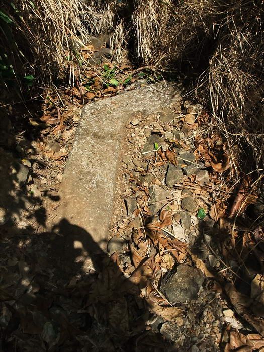 I cleared away some grass and bushes to expose a small section of the I-M-2 gun position. While in the area I remembered Victor and okla commenting on photos taken in the magazine of I-F-2, a rock looked like an old helmet. I went back to take another look and post the results here. 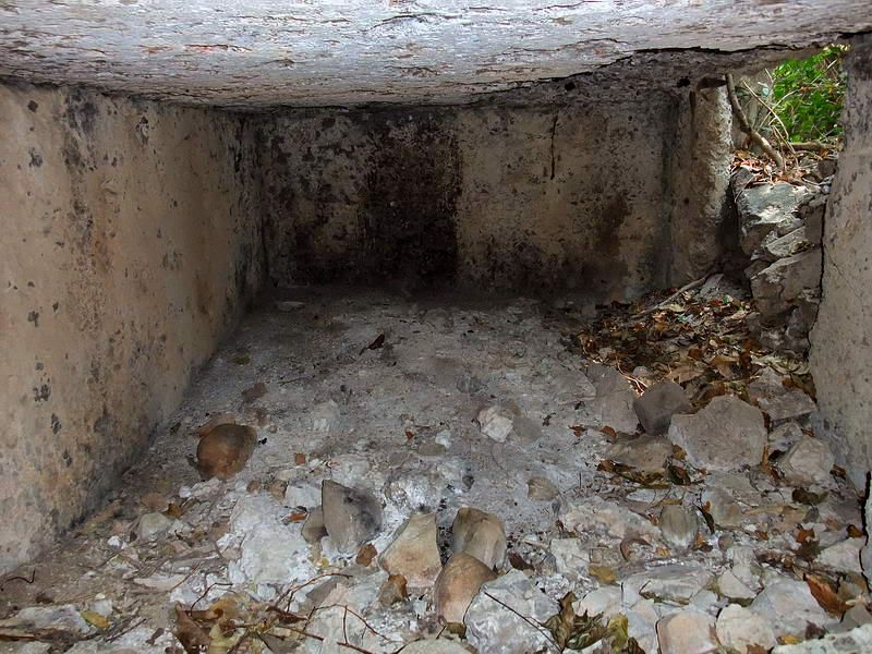 The original photo that shows what may be a helmet. 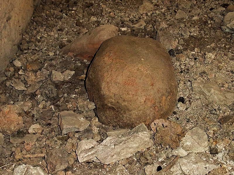 A closer view shows that it is only a rock. Although I did not see any Philippine Cobras this day, I was tramping around their prime territory. I will admit talking to them at times in an attempt to make a little extra noise.  Lack of large tree cover means walking here is very hot plus the bamboo, thorns and high grasses take the fun out of it. A few spots are not bad walking but they do not last long, the north central part is the worst. 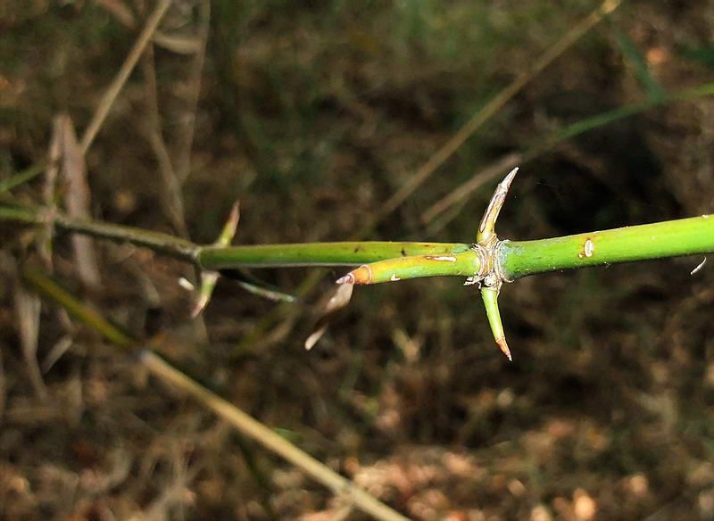 Here is a macro shot of bamboo there that has thorns spaced every foot or so. They are very strong and ripped one pant leg to shreds. I think that makes four pairs of pants I have completely destroyed on Corregidor. There are few signs of war when you can barely see your feet. Unless some very interesting information shows up which requires another visit, I doubt I will be walking north of Kindley again. |
|
|
|
Post by okla on Mar 18, 2012 18:34:57 GMT 8
Hey Fots....Thanks for posting this new stuff. This "mini" Fots Foto Tour may not depict much to the naked eye, but it ought to stir up some "ghosts" that have lurked there since May 1942. This area, to me, is much like the Little Big Horn Battlefield in Montana. Not much to actually see, but as one of the Park guys, at the Custer site, told me, "ghosts literally walk at Mid-Day" at that place. It would be the same to me if I were prowling "no man's land", north of Kindley Field, out on the Tail. That spooky spot was rather important for a few hours on that fateful day in May, way back then. This spot rated one more look, methinks. Thanks again for doing it. You might save that last pair of trousers as a relic. I realize that I have, at least in part, expressed some of these views in the past, but this remote piece of real estate has intrigued me for many, many years. I appreciate you following up with any new material. 8-)Cheers.
|
|
|
|
Post by JohnEakin on Mar 19, 2012 3:48:00 GMT 8
Fots, if this board could issue decorations you'd certainly get one for this report. I just don't know if it would be an award for merit or the cyber equivilent of a purple heart as it looks like you left bits of hide along the way. <G>
Thanks for another FFT.
|
|
|
|
Post by fots2 on Mar 19, 2012 10:18:52 GMT 8
You are very welcome gents.
Getting a few scratches on Corregidor is unavoidable, fortunately that has all it has been so far.
I have never seen any signs of any other people wandering around north of Kindley Field. Usually you can spot bolo cut branches etc but nothing at all. Okla is correct in that even though there is little to see these days, just walking among history is very interesting.
It is time to leave the area to the ghosts. R.I.P.
|
|
|
|
Post by chadhill on Mar 24, 2014 6:27:39 GMT 8
This photo of Ki-21 Sallys flying over Corregidor is from Philippine Expeditionary Force, Manila 1943.  The same photo is reproduced on page 275 of John Gordon's recent book, Fighting for MacArthur (a great read, by the way). According to Gordon the photo was taken "after the surrender...the beached tug Keswick can be seen just off Corregidor's Cavalry Point". Here is an enlarged portion showing the Keswick off Cavalry Point. Note the area of discolored cliffs just above the beach. A SWAG is that this was I-F-3 where 500-600 cases of dynamite and TNT exploded a few days before the surrender, and which fots tried to find in his post back at the end of page 1. See also dmether's map at the very top of this page.  Since it is known that the explosion occurred a few days before the surrender (April 29th or May 3rd depending on the source), I wanted to try and verify that this photo was indeed taken after the surrender, as Gordon claimed. Gordon notes that the tug, which was the USAT Henry Keswick, was beached off Cavalry Point on April 9th after being hit by Japanese artillery. It had been assisting the gunboats Mindanao, Luzon, Oahu and the submarine rescue vessel Pigeon in evacuating US Army refugees from Bataan. The Keswick's skipper, LTJG Trose Donaldson, was the last man off the tug and was hit by an artillery round which killed him instantly. The April 9th, 1942 entry in the Inshore Patrol log (16th Naval District War Diary) notes the beaching of the Keswick and the recovery of Donaldson's body at RJ 15. See entries at 2000 and 2052.   But was the Keswick still beached off Cavalry Point after the surrender of Corregidor nearly a month later? The following photo is from a Japanese newsreel taken in early-mid May. When viewed, the photographer appears to be standing near the curve in the road between RJ 15 and RJ 14. The listing ship at the top would be the Keswick. So, it would appear that the Keswick was indeed still beached at Cavalry Point after the May 6th surrender, and that the pre-surrender explosion devastation on the cliffs near I-F-3 may be seen in the Japanese aerial photo which shows the tug. I think this might confirm fots' suspicion as to why he was unable to find the structures there.  Donaldson, 27, had served with the Merchant Marine until earning a commission in the Navy on November 25, 1940. He had received the Navy Cross for heroism during the Cavite Navy Yard bombing and was posthumously awarded the Distinguished Service Cross for his efforts under fire off the Bataan coast and in evacuating his crew at Corregidor.  The history of the Henry Keswick is sketchy, at best. It was built in 1921 by Hongkong and Whampoa Dock Company, Ltd.  Under the command of New Zealander Hugh Hoskyn Williams, the Keswick left Hongkong on December 5, 1941 towing the British freighter Tantalus to Singapore. When war broke out they diverted to Manila and arrived on December 11th. On the 26th, Japanese aircraft bombed and capsized the Tantalus. The crew was ashore and escaped injury but were captured by the Japanese on January 3rd. Williams died in 1944 at Los Banos. Some British records list the Keswick as "missing" on December 29, 1941. It appears that the US Army confiscated it for service as a tug, and that the USN eventually took it over and placed Donaldson in command. This photo from the Japanese newsreel may be the Henry Keswick. Can anyone confirm this? There appears to have been more aft deck structure added since the 1921 sketch was drawn. Note the hole in the hull. The Japanese may have repaired the tug and put it back in service.  Late entry: Many thanks to EXO and victor for providing the links to view these newsreels: corregidor.proboards.com/thread/300/corregidor-siege-japanese-newsreel |
|
|
|
Post by fots2 on Mar 24, 2014 17:10:47 GMT 8
Hi Chad, Interesting research there. Good job. The ‘Henry Keswick’ story is a glowing sample of how historical information can conflict. Notice where this web site ( Link) says a Norwegian named Torvald Kibsgaard was in charge of the tug ‘Henry Keswick’ in Manila Bay and it was sunk at Corregidor’s North Dock. “Torvald A. Kibsgaard worked as able seamen on this ship, but became sick and paid off in Manila on Sept. 9-1941 where he was admitted to a hospital (from Page 2, we learn that William Strachan had arrived Manila the day before). When the Japanese attacked Pearl Harbor he and some other Norwegians were transferred to a motel in the city. After the attack on Manila they were unable to get out due to the fact that Norwegian ships were directed elsewhere, so in order to avoid internment they all joined the US Navy. Torvald, age 23 was put in charge of the tug S/S Henry Keswick and transported supplies to Corregidor; a Norwegian engineer from Bergen was also on board. On New Years Eve (after D. MacArthur had decided to withdraw) Kibsgaard was again sent to Corregidor, and from then on the 2 Norwegians transported supplies back and forth between Corregidor and Bataan. Henry Keswick was shelled and sunk at "North Dock", Corregidor, and in March the 2 shipmates were on the previously Chinese S/S You Sang. While loading bombs during the battles for Bataan, You Sang was sunk at the Bataan harbour Mariveles. After the fall of Bataan in Apr.-1942, Kibsgaard took part in the ammunition transport to the gun positions on Corregidor using trucks. The day after the invasion, on May 5, he was given a gun and ordered to the trenches with the other soldiers, but when he started to display symptoms of severe shock he was picked up and taken to a hospital at Malinta Tunnel, where he was diagnosed with shock as well as malaria.
After Corregidor had fallen (May 6-1942) he was ordered by the Japanese to clean up after the battles, remove the bodies etc. From then on he was a prisoner of the Japanese.”I think I will believe the Inshore Patrol Log. Link to Citations. CitationsIn case anyone missed it, in my first report, rain kept me from getting to I-F-3 that day. There is an update at the bottom of Page 1 where I did get there and found the big crater. There is an aerial view which appears to show the crater at the former I-F-3. 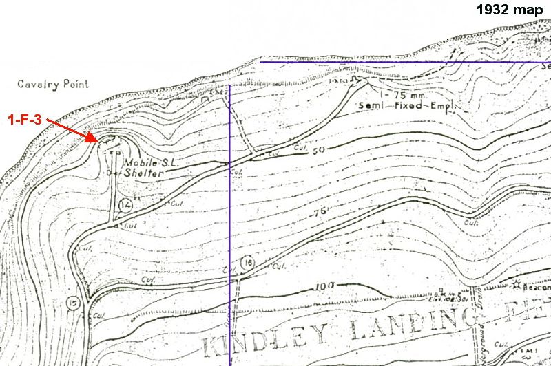 Map showing the location of I-F-3 which was located just back from the cliff at Cavalry Point. 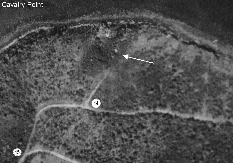 The crater looks to be full of grass and bushes by the time this photo was taken on February 6th 1945. Perhaps an aerial photo interpreter like okla can tell us what he sees. (aerial photo courtesy of Dan’s Collection). 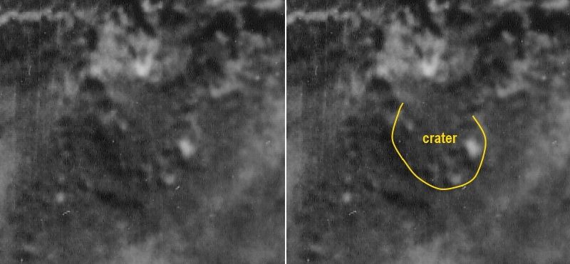 Fuzzy zoom of the crater big enough to fit a house. |
|
|
|
Post by okla on Mar 25, 2014 1:24:09 GMT 8
Hey Chad, Fots....Thanks for posting this excellent material. Lots of "digging" involved, producing "goodies" for us "Geeks" to pour over. Chad....I have a sneaky feeling that your "Commander" had a heavy hand in a good amount of your research. If so, she deserves some kudos. Cheers.
|
|


 ?} detonated by shell fire April 29th".


