|
|
Post by EXO on Jun 30, 2011 8:35:21 GMT 8
I see, or rather, I do not see any reference to it in Keith Barlow's version of " Bunker's War." The two-day period of Monday 5, and Tuesday 6 January are not present in the published manuscript. For the 7th, 8th, 9th and 10th of January, Bunker starts his diary entry with comments about "no bombs." Moore's Report of the campaign at corregidor.org/chs_moorerpt/moore3.htm#Bsays as follows: 6 January saw the fifth consecutive day of severe bombing of Corregidor. From bomb fragments assembled it appeared that 1000 lb bombs were being used, making craters 40-50 feet across.
At Battery Geary (12-in Mortars) where the assigned personnel (Battery H-59th) had been constructing a bombproof shelter, thirty-four men took cover in the incompleted shelter. Unfortunately, a large bomb hit adjacent to the structure collapsing it on the occupants. Three were gotten out, injured and shocked, but the other thirty-one were lost.
President Quezon's yacht the Casiana was bombed and sunk in Corregidor Bay that day also. |
|
|
|
Post by fots2 on Jun 30, 2011 23:09:26 GMT 8
Hi Will,
Would you also ask the veteran what happened to the shelter after the soldiers were removed from it. Was the soil on top of the concrete footing pushed down to seal the entrance?
Thanks.
|
|
|
|
Post by wwalker on Jul 1, 2011 22:22:05 GMT 8
Okay, I will be sure to ask him fots2.
|
|
|
|
Post by The Phantom on Jul 2, 2011 4:58:50 GMT 8
Good job EXO.
Finding the location of this ruined Air Raid Shelter would be important.
Duh!
It was an "Air Raid Shelter" they were building, and we are looking for, denoting fear of AIR RAIDS, bombs from above.
Maybe all the 100 degree days already here in Texas is warping what mind I still possess, 25 since May and plenty more stretching into September!
|
|
|
|
Post by fots2 on Jul 13, 2011 12:48:48 GMT 8
Good day Will,
Have you had an opportunity to speak to the second veteran yet? I am just wondering if you have learned any new information.
I was at Battery Geary last week. For now, I won't say anything as I do not want to influence any 70 year old memories.
|
|
|
|
Post by wwalker on Jul 15, 2011 5:58:33 GMT 8
Hello Fots2,
I haven't been able to get ahold of him this week, but I plan to try again this weekend. The other gentleman that I originally spoke about is in a veterans home now, I just learned. Due to his health I'm not sure I'm going to get to speak with him any further on this stuff. However, I do have a guy that I believe will know the details we need. It is the veteran that supplied me with the details of what the shelter consisted of. I haven't forgot about you guys, and as soon as I get the info I'll pass it along. I am anxious to see what you have come up with as well.
Regards,
Will
|
|
|
|
Post by fots2 on Jul 15, 2011 17:07:39 GMT 8
Hi Will,
Thanks for the bother. More information never hurts, especially from someone who was there.
|
|
|
|
Post by wwalker on Jul 19, 2011 1:59:44 GMT 8
Okay fots, I've got some information as to where this bomb shelter was located. I have been looking at the 2 clippings of maps that you posted on this thread to help guide me through the explanation that I have. The directions I am going to give are as if you are coming down the rail tracks coming to the entrance of Battery Geary. As you come into the entrance there is the mortar pit on the left. About 50-75 yards to the left of the left mortar pit was a large concrete slab perhaps 50 by 100 feet. The veteran I spoke with about this believes that at one time this was a mess hall for the battery. Battery H, 59th CAC constructed some type of cover or roof over this slab for their mess hall. The cover could have been a tent, as he doesn't remember for sure which, only that it was a covered area. This was the slab they constructed the air-raid bunker under. Before the bombardment of Corregidor started there were tents set up in the area also, and one was the CO's office. As I look at the maps you provided in an earlier post there are some structures shown on the 1921 map in this area down from Geary, kind of towards the area of Battery Crockett. This makes even more sense for me, as to the location of the shelter, because there are some men from Battery B (Crockett) 59th CAC that were awarded silver stars on January 06, 1942 for helping dig out the few survivors of the explosion at the shelter. So it would explain why men from Crockett would have arrived on the scene at the shelter, being that it was between Geary and Crockett. I hope this information helps. It seems to make sense that the location was somewhat between Geary and Crockett.
Let me know if I have confused you rather than helped.
Regards,
Will
|
|
|
|
Post by fots2 on Jul 19, 2011 9:22:28 GMT 8
Hi Will, Thanks for the information. I must admit that I am a bit confused though. Just a quick question please. Regarding your comment that the shelter was between Geary and Crockett, is this a bit of an assumption made from what the veteran said or did he specifically say this? The 1932 map has 5 ft contour interval so you can clearly see how steep the embankments are between Geary and Crockett. There is not much of a flat area on top of either ridge either. 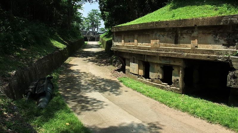 At Battery Geary looking towards Battery Crockett 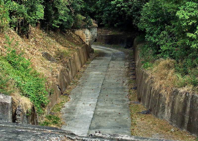 On Battery Crockett looking towards Battery Geary. The two structures you mentioned on the ridge close to Battery Crockett are small secondary Command Posts. One is a bathtub and the other one in rectangular but roughly the same size. I see no remains of concrete platforms on these ridges. From what you heard, is it possible that the shelter was 50 to 75 yards back towards the Plotting Room? Battery Crockett personnel could still come to assist as this spot is approximately 180 yards from Crockett and the ridge is easy to run along. A report of my wandering around Battery Geary is almost finished so I will post it probably tomorrow. I drew a sketch of one area and labeled it as the 'probable' location of the shelter. It still may be correct. Being generally lazy I won't change the label but you can look at the report and form your own decision. It is interesting to explore and learn new things. Thanks again for your help. |
|
|
|
Post by wwalker on Jul 19, 2011 10:46:25 GMT 8
Hey fots,
It was an assumption on my part about it being between Geary and Crockett. He is going to draw me up a mapping of the Geary area of what he remembers. Once I get this it should give us more details. I can say for certain that the location of the shelter was about 50-75 yards from the mortars in one of the mortar pits at Geary. I just need to get my direction clarified. I've never been to the Rock (although I plan to visit someday) so my perception of all this is not very good. I have been looking at maps and pictures to try to gain a better grasp of the layout of the area. Apparently I misunderstood the direction he was talking about from the mortar pits. It could be that it was towards the plotting room. Let me get my details straight, and I will get back with you.
I appreciate your help and your time.
Regards,
Will
|
|


