|
|
Post by Karl Welteke on Feb 8, 2021 6:25:24 GMT 8
Paul, thank you for all your great work. They ought to give you a award for that.
|
|
|
|
Post by Karl Welteke on Feb 4, 2021 11:17:28 GMT 8
Manila Bay Mining 14th Dec 1944. en.wikipedia.org/wiki/No._76_Wing_RAAFNo. 76 Wing RAAF Note from Karl: In case you did not take the time to read the above Wikipedia URL here is more of the text copied! No. 76 Wing headquarters was established at Townsville, Queensland, on 3 January 1944, and moved to Cairns mid-month.[1] Led by Wing Commander Reginald Burrage,[2][3] it transferred to Darwin, Northern Territory, in September to coordinate and control minelaying operations in the North-Western Area by Nos. 20, 42, and 43 Squadrons. Each of the squadrons was equipped with PBY Catalina flying boats, nicknamed "Black Cats"; No. 20 had been based in Cairns with No. 76 Wing headquarters, No. 42 had just been formed at Darwin in August, while No. 43 had been operating out of Darwin since March. Minelaying missions carried out by the RAAF over the past year had been credited with successfully disrupting enemy shipping for a much smaller outlay of operating hours than conventional bombing, and were thus considered profitable enough to dedicate a wing with three squadrons to furthering the work.[3][4] Although the Catalinas were relatively slow and susceptible to enemy fighter attack, their loss rate was no more than one per 95 sorties.[3][5] In addition to its flying squadrons, the wing controlled No. 2 Flying Boat Maintenance Unit, No. 11 Air Sea Rescue Flight, and No. 3 Mobile Torpedo Unit. All units were located in Darwin except No. 42 Squadron, which was based at Melville Bay. The Catalina squadrons were expected to carry out a total of 100 missions per month from Darwin. In their first three weeks of operation from 13 September 1944 they accomplished 98, mining targets in Celebes, Java, and Surabaya. In October, they were able to use the recently liberated island of Morotai as a forward base for operations against Balikpapan and Tarakan.[7] On 14 December, No. 43 Squadron, augmented by Catalinas from No. 11 Squadron based at Rathmines, New South Wales, mined Manila Bay to keep Japanese shipping "bottled up", thus supporting the Allied landing at Mindoro taking place the next day. Flying from Leyte, the 24 Catalinas successfully dropped 60 mines in the heavily defended target area for the loss of one of their number, and returned to base at the limit of their fuel reserves. |
|
|
|
Post by Karl Welteke on Feb 3, 2021 17:09:10 GMT 8
Australian WWII Memorial on Bataan I put this new thread in the Remembering Bataan Group. This Australian mining operation supported the Mindoro Landing which in turn supported the Paratroopers who liberated Corregidor and the Memorial is on Bataan. On this Bataan trip I visited Bob Hudson in Limay to see how he is doing. He told me that an English friend and he just by accident discovered the sign for the Australian Memorial and Bob told how to find it, and I sure took him up on it. Thanks Bob, he has an interesting personal blog: bataanson.blogspot.com/ Wikepedia has this information about RAAF mining operation all over the battle area Of General MacArthur at this URL: en.wikipedia.org/wiki/No._76_Wing_RAAFNo.76 Wing RAAF, Black Cat Catalinas On 14 December, No. 43 Squadron, augmented by Catalinas from No. 11 Squadron based at Rathmines, New South Wales, mined Manila Bay to keep Japanese shipping "bottled up", thus supporting the Allied landing at Mindoro taking place the next day. Flying from Leyte, the 24 Catalinas successfully dropped 60 mines in the heavily defended target area for the loss of one of their number, and returned to base at the limit of their fuel reserves 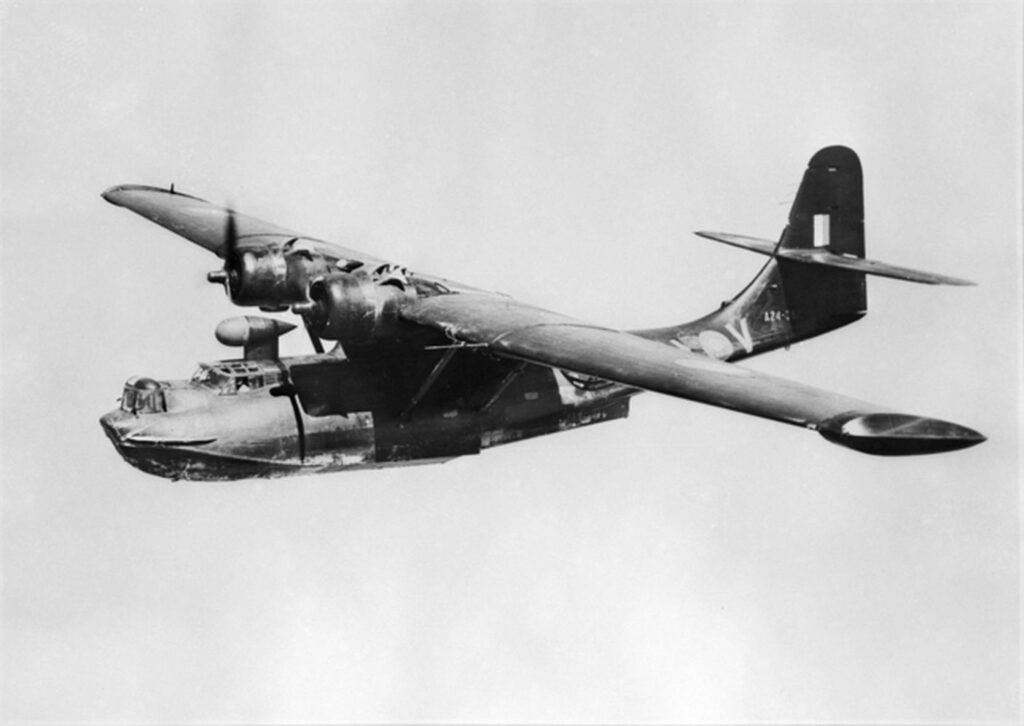 Zd901. 43_sqn_(AWM_128022) Black Cat Catalina. A Black Cat Catalina like this one is assumed to went down with the loss of the whole crew in Manila Bay.  Zd902. One of several images of the Australian WWII Memorial located just inside the Main Gate of the Maritime Academy of Asia and the Pacific (MAAP). The gate is located, right side on the long road down to Kamaya Point Piers from the Cabcaben to Mariveles Road. This is part of Barangay Alas-asin, Mariveles, Bataan. 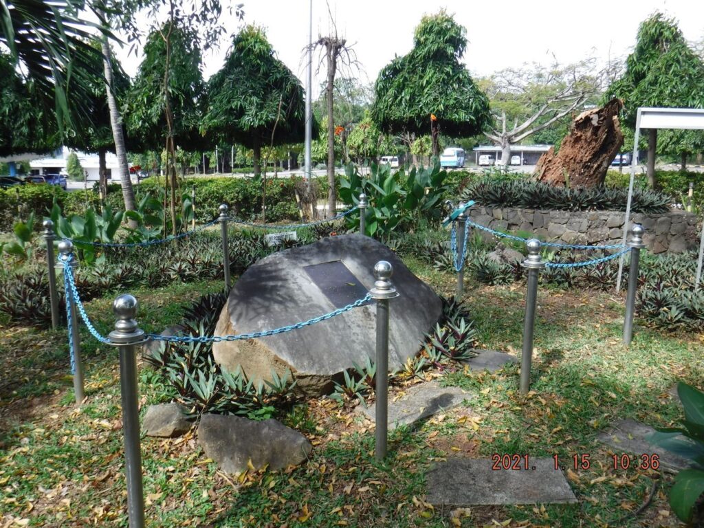 Zd903. One of several images of the Australian WWII Memorial located just inside the Main Gate of the Maritime Academy of Asia and the Pacific (MAAP). The gate is located, right side on the long road down to Kamaya Point Piers from the Cabcaben to Mariveles Road. This is part of Barangay Alas-asin, Mariveles, Bataan. 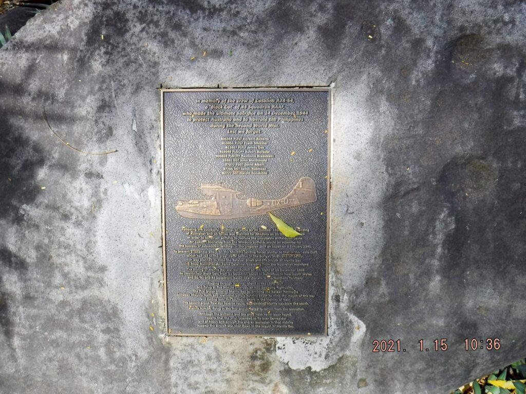 Zd904. One of several images of the Australian WWII Memorial located just inside the Main Gate of the Maritime Academy of Asia and the Pacific (MAAP). The gate is located, right side on the long road down to Kamaya Point Piers from the Cabcaben to Mariveles Road. This is part of Barangay Alas-asin, Mariveles, Bataan.  Zd905. One of several images of the Australian WWII Memorial located just inside the Main Gate of the Maritime Academy of Asia and the Pacific (MAAP). The gate is located, right side on the long road down to Kamaya Point Piers from the Cabcaben to Mariveles Road. This is part of Barangay Alas-asin, Mariveles, Bataan. 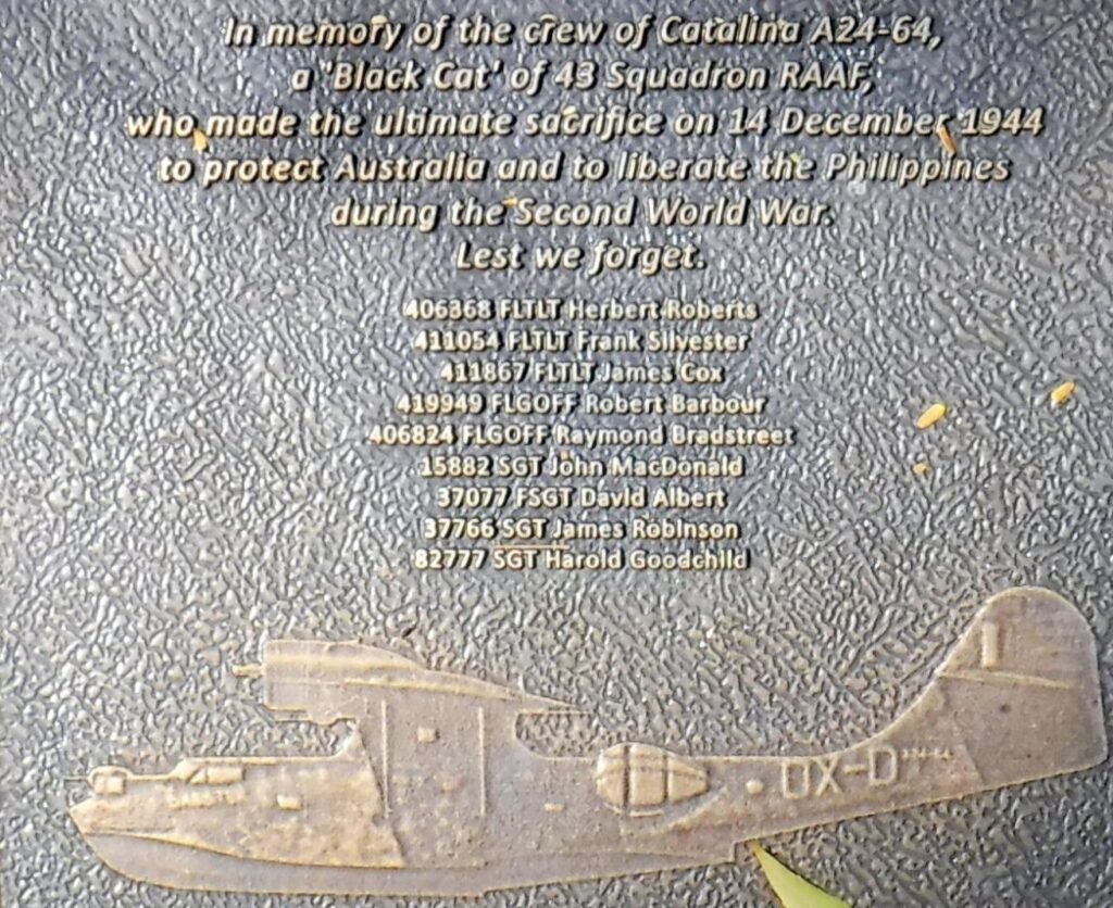 Zd906. In memory of the crew of Catalina A24-64, a Black Cat” of 43 Aquadron RAAF who made the ultimate sacrifice on 14th December 1944 to protect Australia and liberate the Philippines during the Second World War. Les we forget. 406368 FLTLT Herbert Roberts 411054 FLTLT Frank Silvester 411867 FLTLT James Cox 419949 FLGOFF Robert Barbour 406824 FLGOFF Raymond Bradstreet 15882 SGT John MacDonald 37077 FSGT David Albert 37766 SGT James Robinson 82777 SGT Harold Goodchild 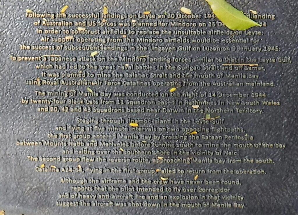 Zd907. On 14 December 1944, No. 43 Squadron, augmented by Catalinas from No. 11 Squadron based at Rathmines, New South Wales, mined Manila Bay to keep Japanese shipping "bottled up", thus supporting the Allied landing at Mindoro taking place the next day. Flying from Leyte, the 24 Catalinas successfully dropped 60 mines in the heavily defended target area for the loss of one of their number, and returned to base at the limit of their fuel reserves 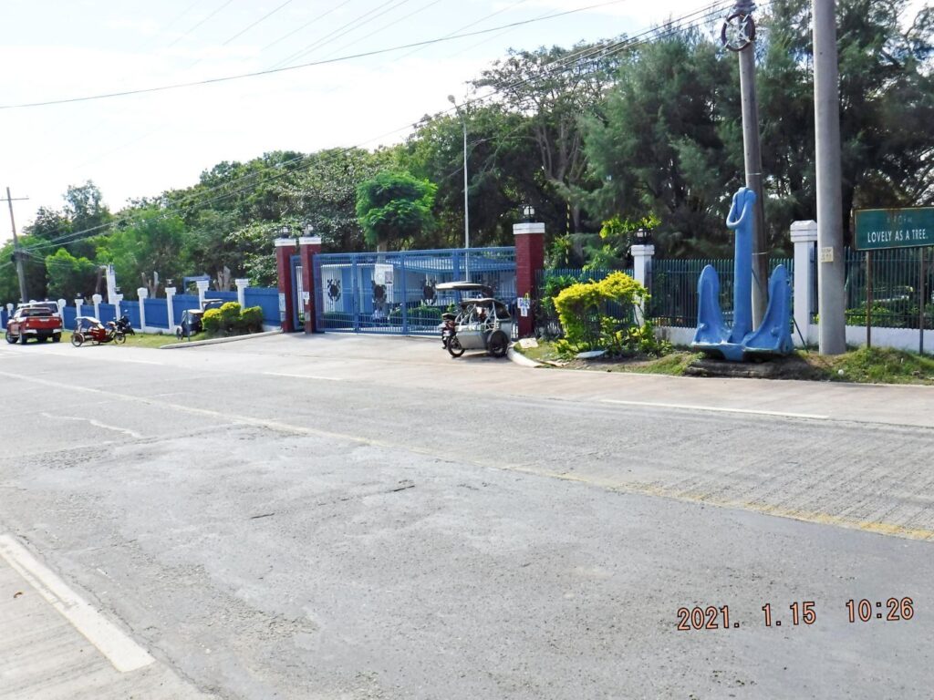 Zd908. One of 5 images of the Main Gate area of the Maritime Academy of Asia and the Pacific (MAAP). The Australian WWII Memorial is located just inside the Main Gate of MAAP. The gate is located, right side on the long road down to Kamaya Point Piers from the Cabcaben to Mariveles Road. This is part of Barangay Alas-asin, Mariveles, Bataan. 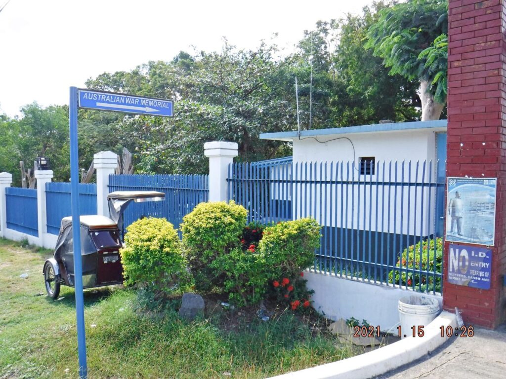 Zd909. One of 5 images of the Main Gate area of the Maritime Academy of Asia and the Pacific (MAAP). The Australian WWII Memorial is located just inside the Main Gate of MAAP. The gate is located, right side on the long road down to Kamaya Point Piers from the Cabcaben to Mariveles Road. This is part of Barangay Alas-asin, Mariveles, Bataan. 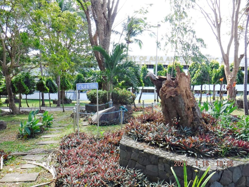 Zd910. One of 5 images of the Main Gate area of the Maritime Academy of Asia and the Pacific (MAAP). The Australian WWII Memorial is located just inside the Main Gate of MAAP. The gate is located, right side on the long road down to Kamaya Point Piers from the Cabcaben to Mariveles Road. This is part of Barangay Alas-asin, Mariveles, Bataan.  Zd911. One of 5 images of the Main Gate area of the Maritime Academy of Asia and the Pacific (MAAP). The Australian WWII Memorial is located just inside the Main Gate of MAAP. The gate is located, right side on the long road down to Kamaya Point Piers from the Cabcaben to Mariveles Road. This is part of Barangay Alas-asin, Mariveles, Bataan. 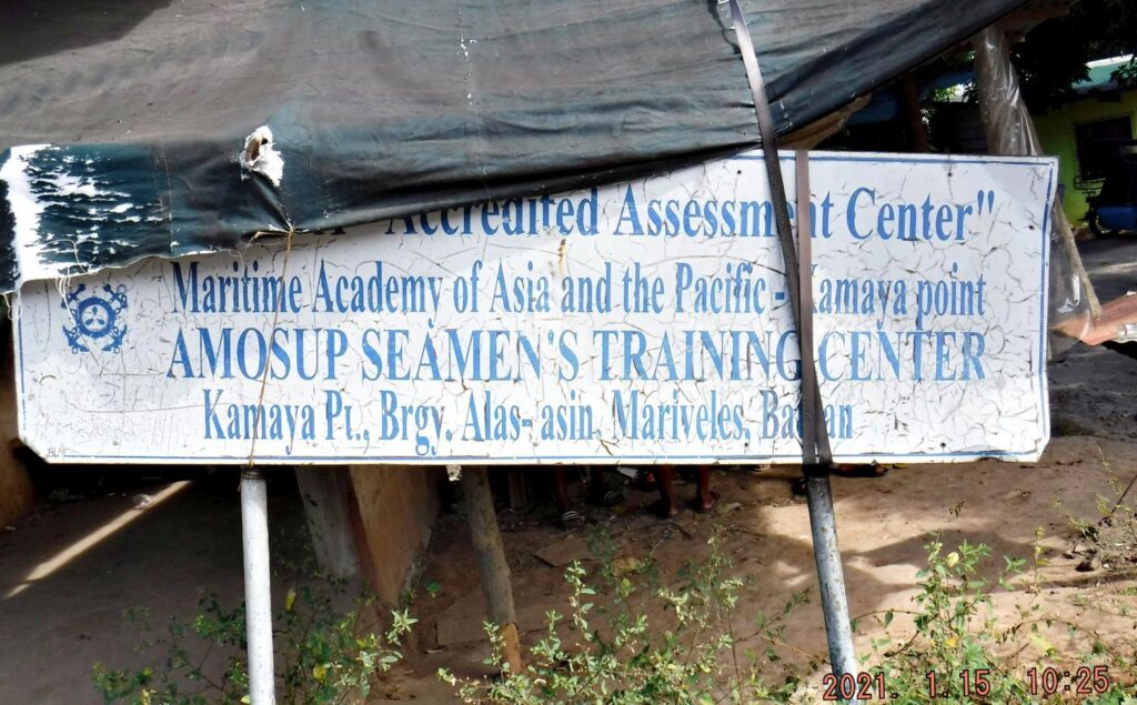 Zd912. One of 5 images of the Main Gate area of the Maritime Academy of Asia and the Pacific (MAAP). The Australian WWII Memorial is located just inside the Main Gate of MAAP. The gate is located, right side on the long road down to Kamaya Point Piers from the Cabcaben to Mariveles Road. This is part of Barangay Alas-asin, Mariveles, Bataan. This discarded sign was located at a vendors stall just across the street from the Main Gate I actually made one album with all the venues of this trip into this album, but it is a long one: philippine-sailor.net/2021/01/19/bataan-trip-21-01-15/ |
|
|
|
Post by Karl Welteke on Jan 27, 2021 16:48:37 GMT 8
|
|
|
|
Post by Karl Welteke on Jan 27, 2021 15:41:57 GMT 8
Fourth and last Segment. Grande Island, ex Fort Wint, Update Visit 2021-01-22 This section is about the Grande Island Resort. Grande Island was not used for any purpose after the Naval Base closed in 1992. In 2004 or just before that, investors got a deal with the new Subic Bay Freeport management to develop it as a resort. It opened in 2004 or shortly thereafter. Some of us had a sneak view in 2004 and that event has been presented in our forum. I’m not a businessman but I dare say that the Grande Island Resort never became a resounding success. I lot of money has been put in but I don’t think the investor got their money back. Less they have another goal? The prices quoted to me were high and I paid 3000 peso for a day visit. I think very few visitors are actually visiting. One more thing concerns me, all the Fort Wint concrete structures become more and more inaccessible do to overgrowth and the woods, off road, also become a wilderness and almost in accessible now. Here, I present 9 pictures of the resort: 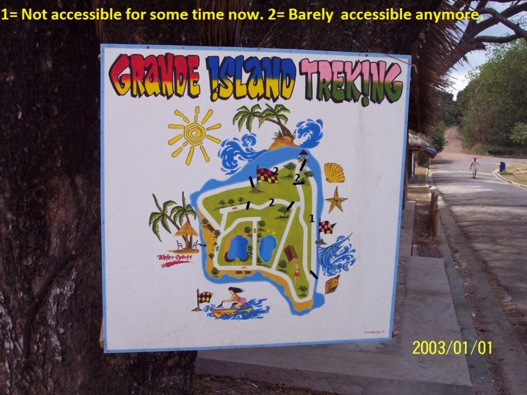 Zd881. This is an old resort map posted a few years ago, and is not available anymore. I marked it up to indicate that some roads are barely accessible anymore and one is completely grown over. 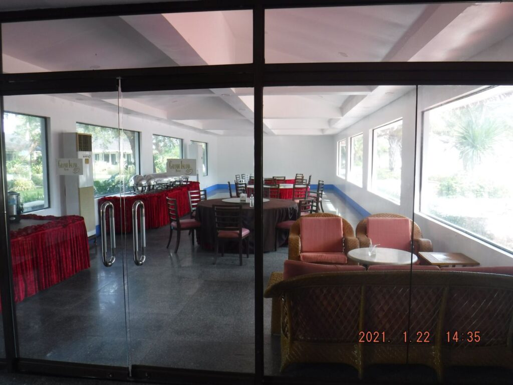 Zd882. This is the dining room in the resort main structure, it also houses the reception and a bar area. And the building has a function room and it is has mostly glass walls to the poolside. 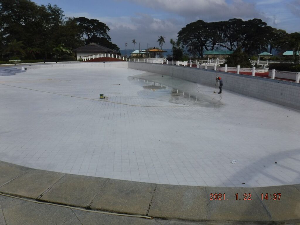 Zd883. The resort has a very large pool but it is being cleaned right now. 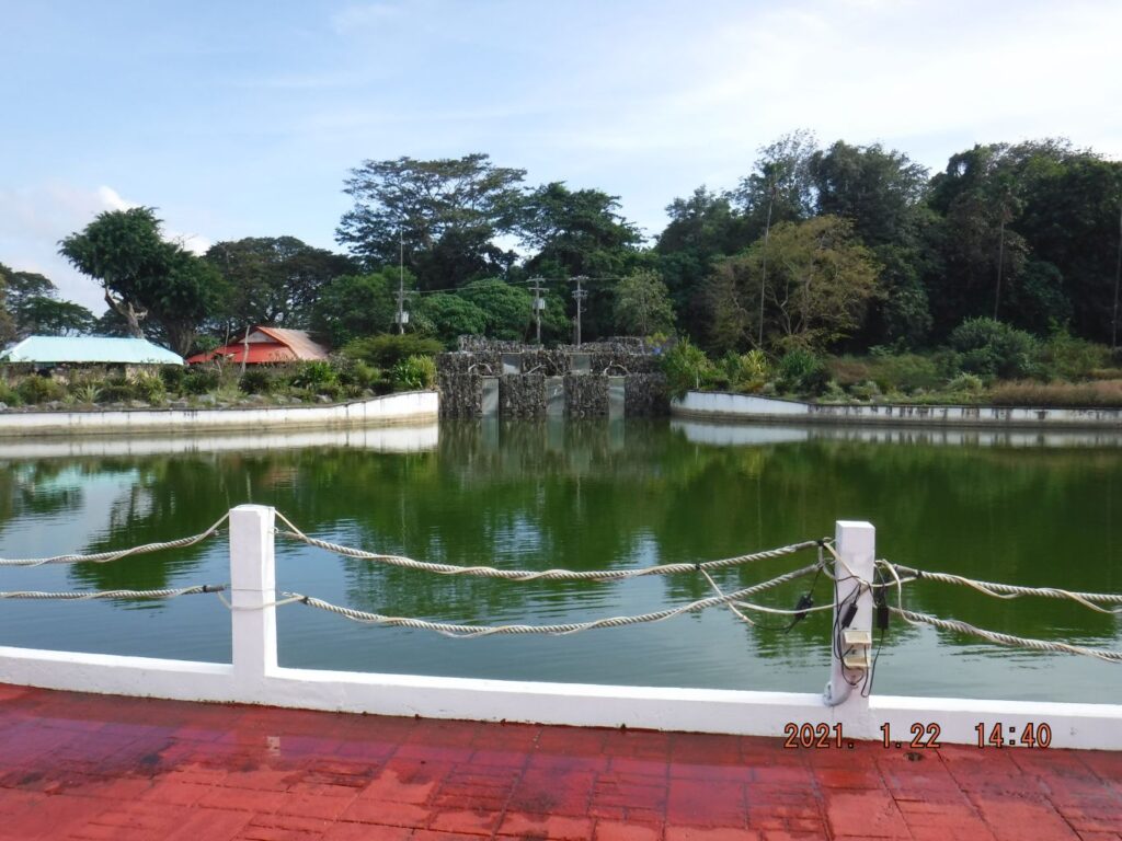 Zd884. That structure in back camouflages the wave making structure. The former Navy base ball field was converted to a lagoon but the wave making system was never used or a very short time only. 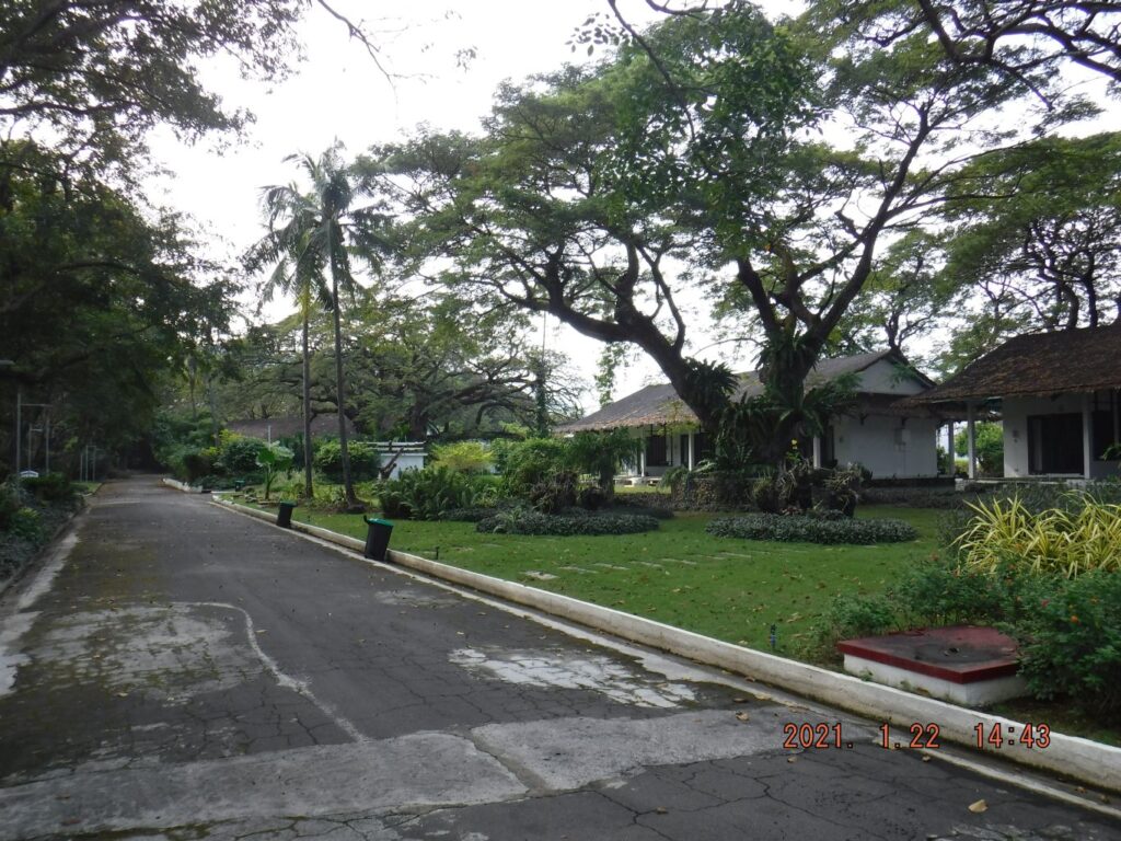 Zd885. The main features of the Grande Island Resort were these chalets, they replaced everything on the island north shore, of what the Army Fort Wint and later the Navy recreational service had there. But the large trees and other tropical landscaping are impressive. Maybe the Army planted them. 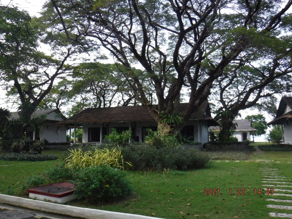 Zd886. The main features of the Grande Island Resort were these chalets, they replaced everything on the island north shore, of what the Army Fort Wint and later the Navy recreational service had there. But the large trees and other tropical landscaping are impressive. 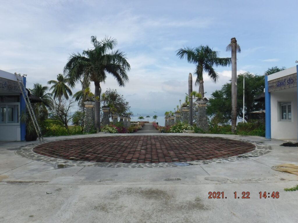 Zd887. At the round circle stood the 2004 reception structure. It was built out of native materials and apparently had to go. 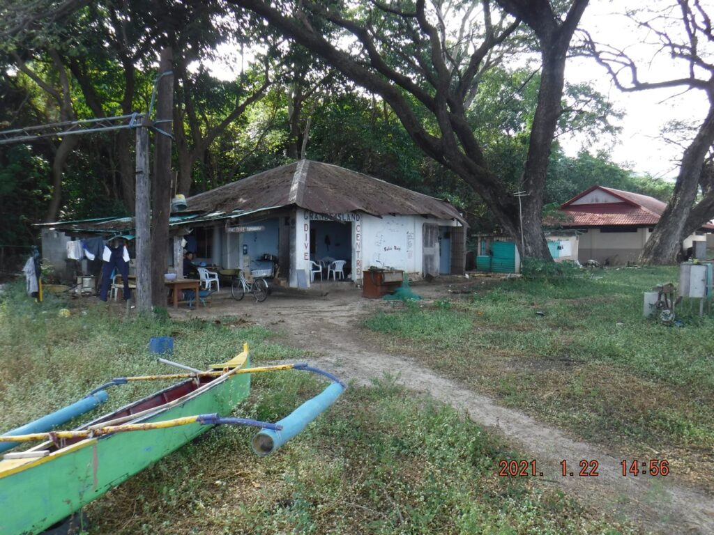 Zd888. On the east side of the island is the Grande Island Diving Locker and other structures to support recreational activities. 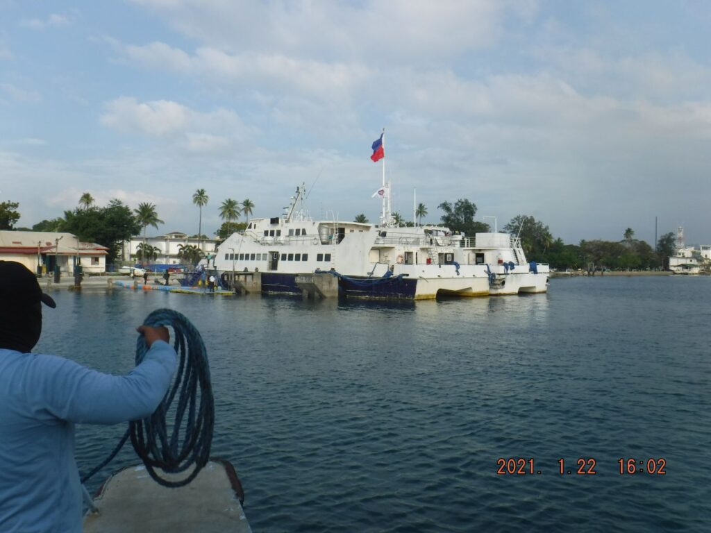 Zd889. We are about to land where we started out this morning, the former Navy officer boat landing which is now the Grande Island Resort Terminal. I enjoyed the trip. After all, that was my goal, to get an update on this historical Island in the famous Subic Bay. |
|
|
|
Post by Karl Welteke on Jan 26, 2021 18:50:38 GMT 8
Third Segment In this segment I visited 4 out of the 5 Army Coastal Gun Batteries and other military structures. As I said before this presentation is just a short overview of the visit and only few images are presented. In the future maybe I will/may present more. 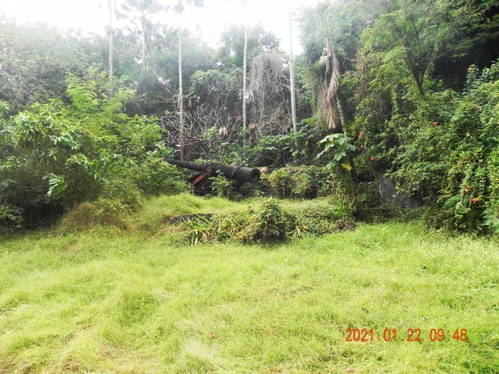 Zd871. No 1 Six Inch Disappearing Gun of Battery Hall. As I said before, the present management seems to have fewer resources in keeping the guns accessible than 2 years ago when my friend Charlie and I visited. 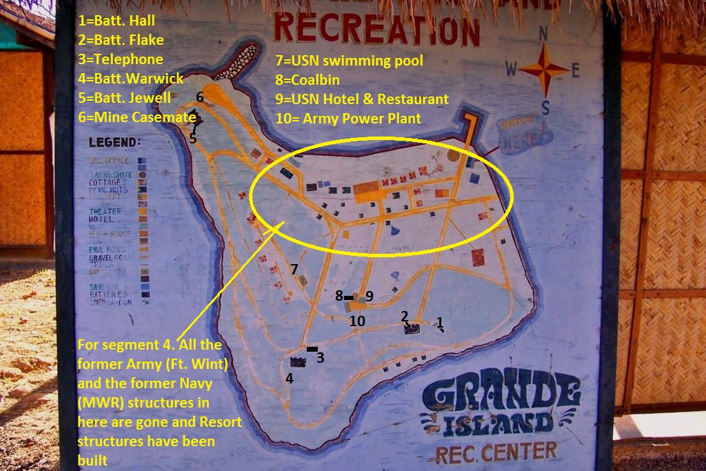 Zd871a. For this 3rd segment of 10 images, this former Navy Moral, Welfare and Recreation (MWR) map is provided. I marked on it the various venues or items of this 3rd segment. But it also has a note for the fourth and last segment. 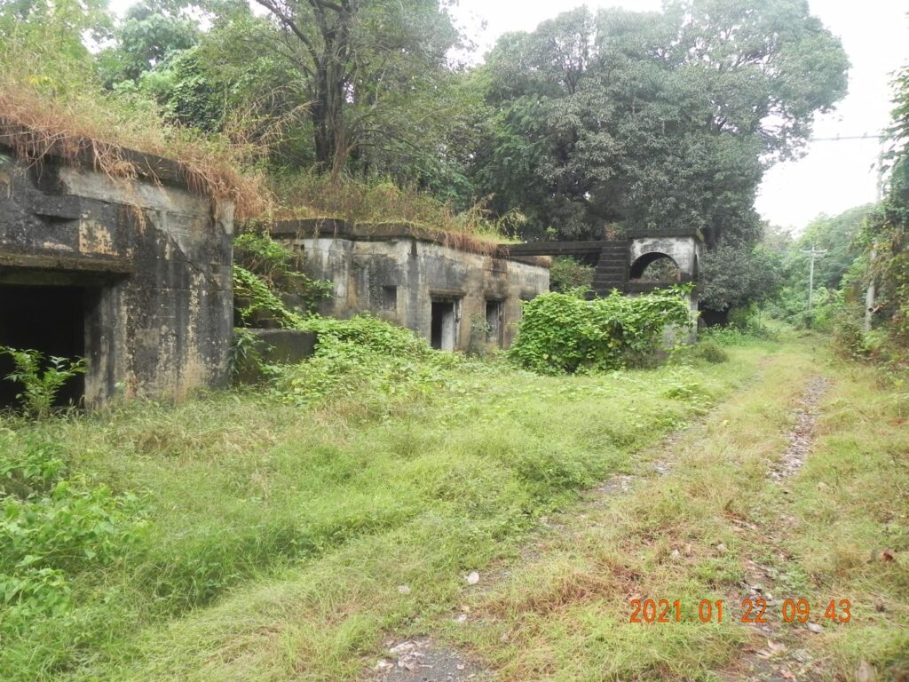 Zd872. Battery Flake and the road that leads to Battery Warwick and passé by the Fort Wint Telephone Exchange also called the SBR.  Zd873. The Fort Wint Switch Board Room (SBR), I knew the building was here since 2004, and then it could be seen from the road; but I never looked inside until this visit. It is large, has two rooms and is located behind Battery Warwick and the berm dirt of that battery is invading the SBR. 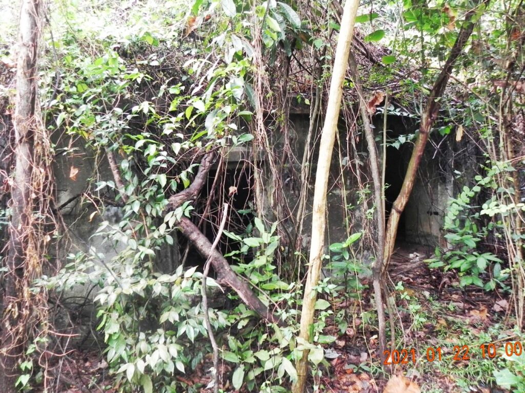 Zd874. The Fort Wint Switch Board Room (SBR), I knew the building was here since 2004, and then it could be seen from the road. So, this time I took advantage of this visit, entered and took pictures. The building is now completely hidden because of the vegetation, in the about 20 years since my first visit after the bases closed. I had to go thru bushes to get this view.  Zd875. Battery Warwick is still locked up and we can assume that the Doppler radar on top of it is being used or as at a minimum kept secure. There are personnel here and they have a vicious looking dog. I understand Terry McGovern (of CDSG Fame) was unable to enter during his 2nd Feb. 2020 visit. Battery Warwick has become personal to me. A very close friend and fellow Navy Diver (we served together in 4 different Commands) participated as paid volunteer to take the 10 inch guns apart and ship them to Washington State. I have made 2 albums about this event: ex Fort Wint on Grande Island Visit with Charlie 2018-07-20 Battery Warwick Guns are not forgotten. Click here for the 1st album: philippine-sailor.net/2018/07/22/ex-fort-wint-on-grande-island-visit-with-charlie-2018-07-20/And click here for the 2nd album: philippine-sailor.net/2018/07/18/battery-warwick-guns-are-not-forgotten/If you ever want to visit pressure the resort management to get it open or go directly to the Subic Bay Metropolitan Authority (SBMA) which manages the Subic Bay Freeport (SBF). 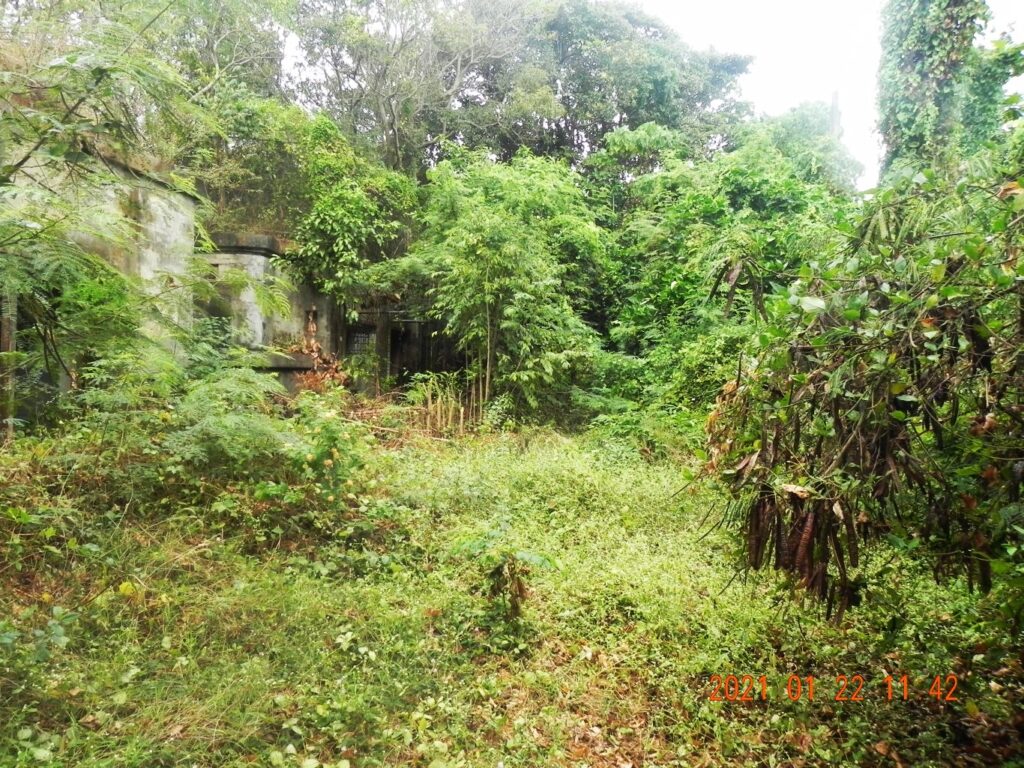 Zd876. This is Battery Jewell, in this picture the growth of vegetation looks worse than it is. But it is worse than two years ago. Here I noticed that the three Navy watch towers have be removed from the island in the last 2 years. 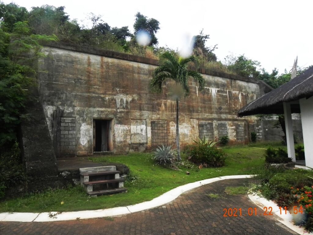 Zd877. The Fort Wint Mining Casemate, The wires to the mines run out from under this structure thru two small tunnels, I have crawled thru one of them in the past. Until two years ago all doors and windows were closed. This one door was opened in the last 2 years, thank you to the resort. Naturally I went inside to have a look. 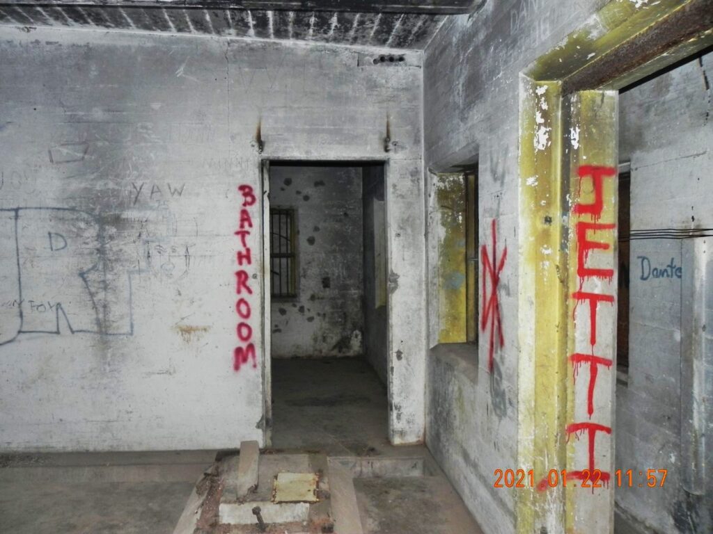 Zd878. This is pretty much the end of the right end of the Casemate. I did not have a flashlight and I promptly fell over this machinery base, in front of me here in this image and lost my virus shield. I was glad to have looked inside. Next visit, I will look a little closer! 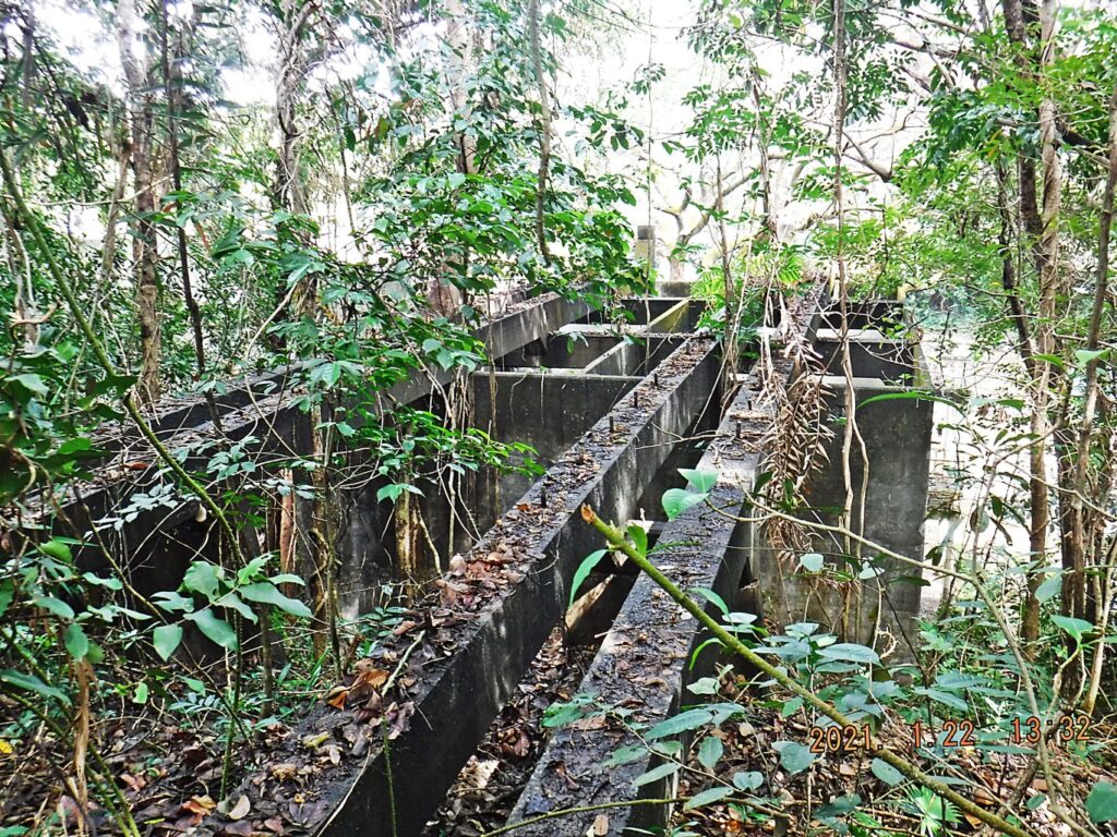 Zd879. This is one of the Fort Wint power house coal bins, this one is attached to the ex Army building, the Navy used as a hotel. I took this picture when I was searching for what might have been a Fort Wint Flagstaff. There is another coal bin at the other end of the power house. On my map I marked two buildings with the number 9. I believe those two ex Army buildings were used by the Navy as a hotel and restaurant. The resort, right now is just using them as storage and they do not look very taken care of. The flat concrete roof of the power house is pretty much shot. I would not want to go on top now, I did in 2004. 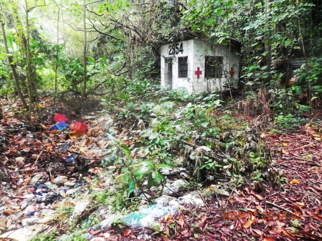 Zd880. This is the swimming pool, which, I assume, was built by the Navy. In 2004 it didn’t have water but it was clean and no trash was in it. If you look on the Navy map it is next to the road that runs parallel to the 7 cottages. I assume those cottages were built by the Navy also. Those buildings and this pool are trashed now from all the commercial activity on Grande Island since 2004. I did not look at the cottages this time, or Battery Woodruff, the Mine Control,-Radio and one Fire Control Building this time. All these structures are intermingled or are near parallel to the cottages. And we know Battery Woodruff is blown up and not very much is left. |
|
|
|
Post by Karl Welteke on Jan 25, 2021 16:30:09 GMT 8
Grande Island, ex Fort Wint, Update Visit 2021-01-22 Second Segment I had two specific goals in mind to find things and I failed.  Zd862. What was this, I wanted to try to find it? This is a cropped portion of a prior 1932 picture of Fort Wint on Grande Island in Subic Bay. This was my search item # 1 and I searched on the 22nd Jan. 2021 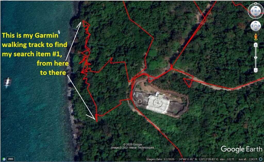 Zd863. This was part of my Garmin GPS hand held devise walking track on Grande Island the former Fort Wint to look for my search item #1. I did not find it. I was actually walking on an old road. That road is indicated on the Navy MWR map, posted earlier on this page. It was difficult to walk because of the overgrown condition but was doable. 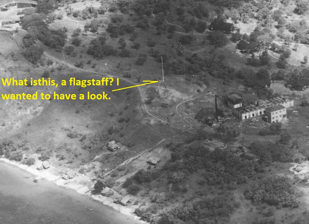 Zd864. What was this, a flagstaff (from a Spanish war ship, like on Corregidor, just yoking?). I wanted to try to find it? This is a cropped portion of a prior 1932 picture of Fort Wint on Grande Island in Subic Bay. This was my search item # 1 and I searched on the 22nd Jan. 2021 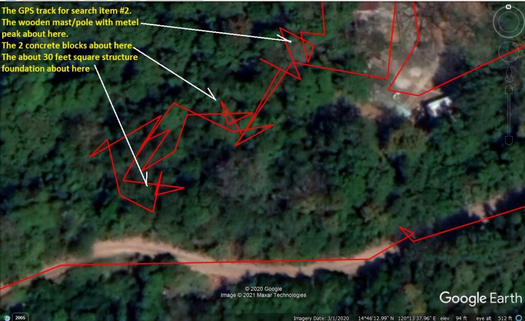 Zd865. This was part of my Garmin GPS hand held devise walking track on Grande Island the former Fort Wint to look for my search item #2. I did not find it. It was difficult to walk because of the overgrown condition but it was doable. But I did find a building foundation, made out rock and is cemented. It is about 30 feet square and the foundation is about 2 feet high. I saw two big concrete blocks (perhaps 3x4x6 feet in size) and a wooden mast, tarred, and with an about 5 feet long metal peak. 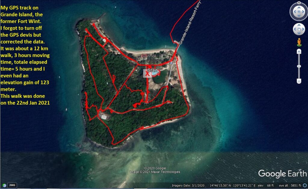 Zd866. This was my Garmin GPS track walking on Grande Island, the former Fort Wint. I forgot to turn of the device and had to correct the data. It was about a 12km walk; about 3 hours actual moving, 5 hours total elapsed time and I even had an elevation gain of 123 meters. --------------------------------- The next 4 items are great images of Grande Island in the 80s and 2 aerial shots of Fort Wint on Grande Island which were shot prior 1932. Here they are presented as whole images but are seriously reduced in resolution. Each picture will have an URL which can be used to download the picture in high resolution.  Zd867. This is an aerial photo of Fort Wint on Grande Island in Subic Bay prior 1932. Received this picture from NARA via CDSG member Karl Schmidt, he had it numbered #21. This picture can be downloaded in high resolution with this URL, click here: www.flickr.com/photos/44567569@N00/50872387308/in/album-72157715590015061/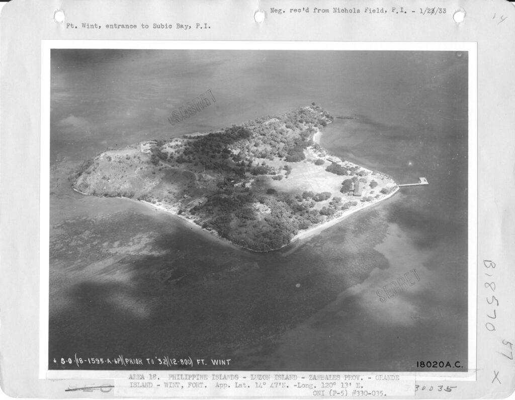 Zd868. This is an aerial photo of Fort Wint on Grande Island in Subic Bay prior 1932. Received this picture from NARA via CDSG member Karl Schmidt, he had it numbered #20. This picture can be downloaded in high resolution with this URL, click here: www.flickr.com/photos/44567569@N00/50873194197/in/album-72157715590015061/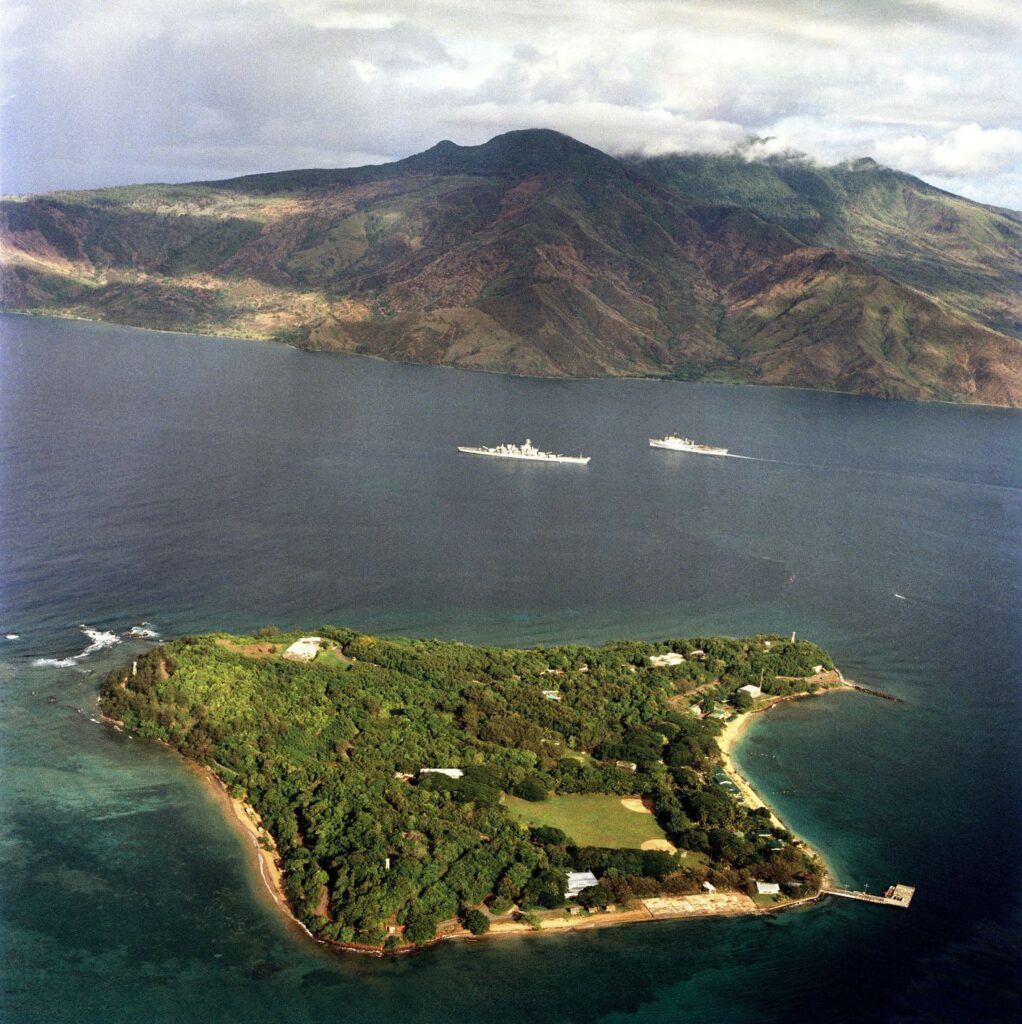 Zd869. This is a 1983-02-14 Grande Island picture from NARA via Wikipedia with Battleship New Jersey BB-62 and a LSD or LPD passing each other. Now that is a Navy picture, it makes a sailor like me, proud as heck; did diving work under that Battle wagon in Subic and served on two LSDs. This picture can be downloaded in high resolution with this URL, click here: www.flickr.com/photos/44567569@N00/50872387223/in/album-72157715590015061/ 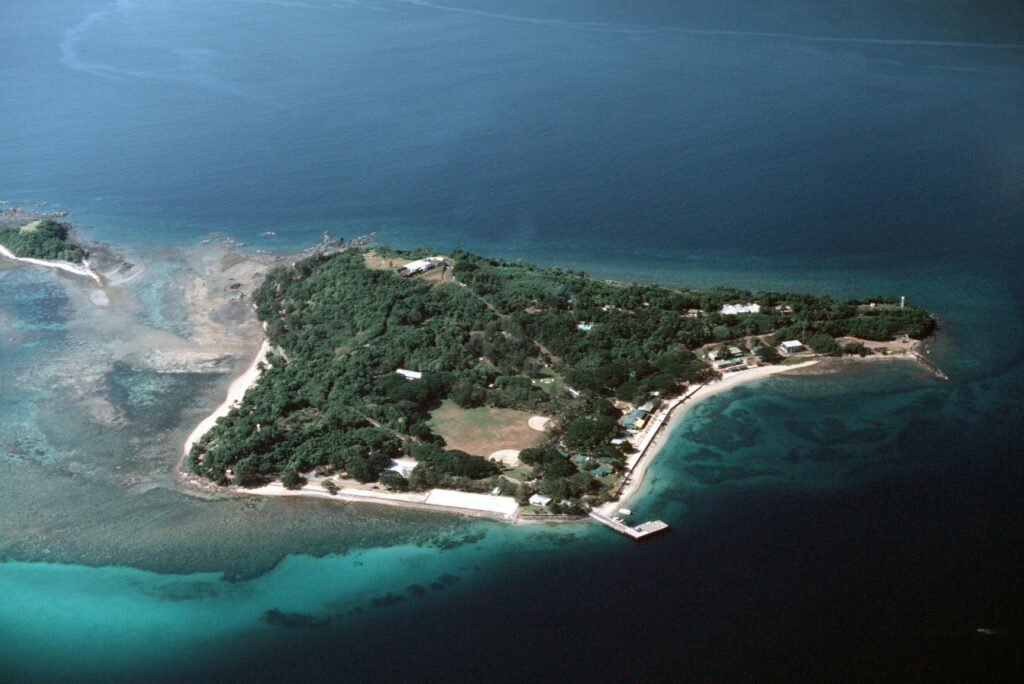 Zd870. This is a 1983-02-14 Grande Island close-up picture from NARA via Wikipedia when used by the US Navy. It has a lot of history, starting with Spanish American War, then the Philippine American war; the Marines prepared it for coastal defense and then the Army took it over and built Fort Wint, etc. This picture can be downloaded in high resolution with this URL, click here: www.flickr.com/photos/44567569@N00/50873090456/in/album-72157715590015061/ |
|
|
|
Post by Karl Welteke on Jan 24, 2021 17:14:18 GMT 8
Grande Island, ex Fort Wint, Update Visit 2021-01-22 After being absent from the Philippines for 15 months, I had the desire to visit the island again. Searching the internet and contacting old contacts, I made contact and offer this information: Facebook Page, click here: www.facebook.com/GrandeIslandResortOfficialTwo good phone numbers: 0939 128 0203 and 0965 799 6691 An email address: grandeislandsales@gmail.com it is good address and did the trick for me. They offered a day tour for 3000 peso, to include, the boat transportation and three meals. I wanted to see the island bad enough and paid the high price. The staff was very friendly, like in most local businesses. I didn’t meet any manager or investor/owner of the enterprise and don’t know anything about them. I believe this resort was opened in 2004, that the investors are Chinese, the investors or the managers may have changed hands since then, but I just don’t know! This is just a short overview of the visit and I will do it in segments, posting materials is work! This first segment has 10 images. Later perhaps, I will make more detailed presentations. 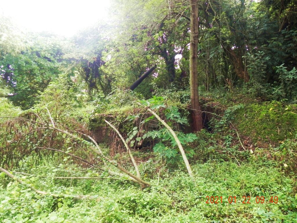 Zd856. Number 2 Gun of Battery Hall. The present management of the Grande Island Resort appears to have even less resources to keep the Coastal Defense Gun Batteries of the former Fort Wint presentable and accessible. 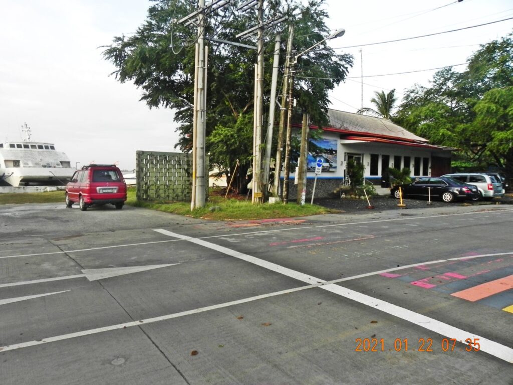 Zd857. This is the ferry boat terminal to the Grande Island Resort, built just before 2004; it is still there and serves the same purpose. I was told that the boat will pick me up here at o800 Hours. 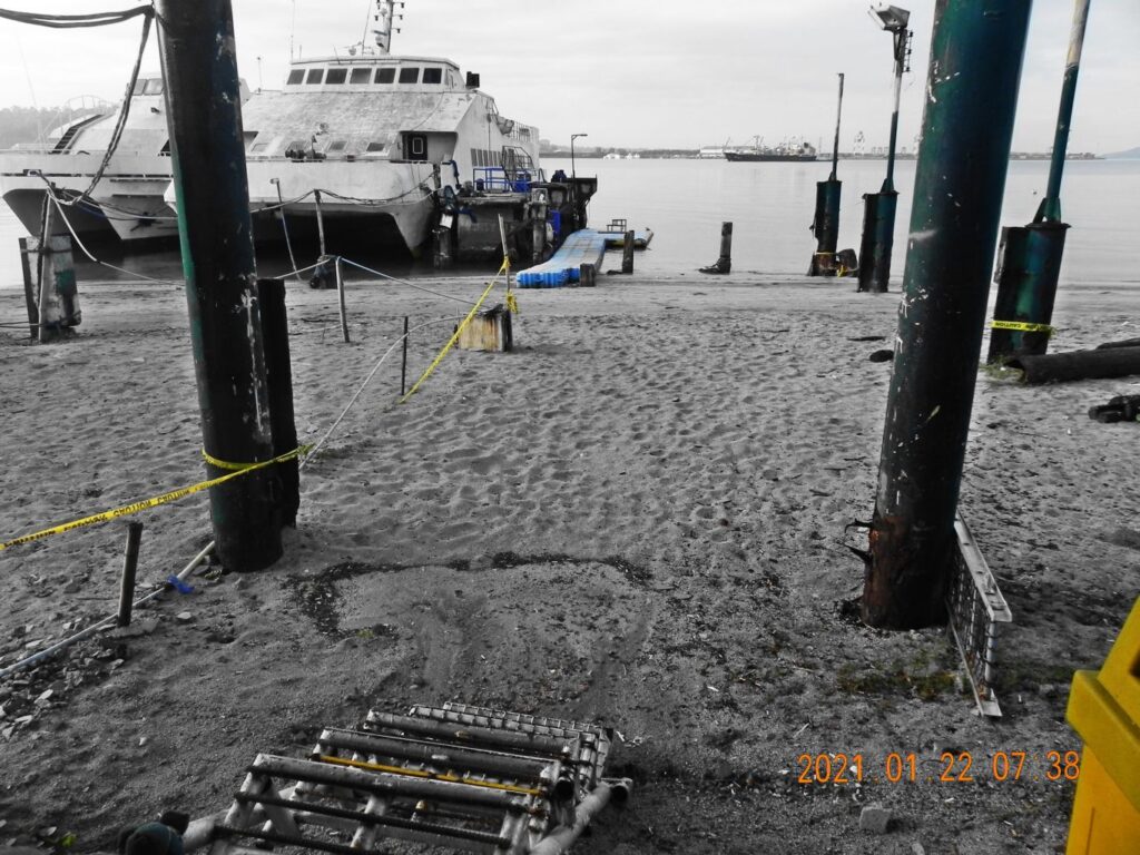 Zd858. These 2 big boats have been here since 2004, they will not be used for my purpose today. I noticed that some crew members were on board. This original 2004 boat landing was a lot more elaborate, much of has rusted too much and is torn down now. By the way, this was the site of the Navy Officer Boat Landing here. The former Navy Officer Club, now a casino, is just to the right. The Enlisted boat landing was about 100 meter to the left and I stepped ashore onto Philippine soil for the first time in 1962, and liked this place ever since. 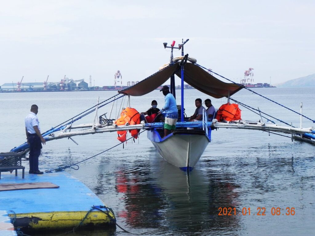 Zd859. This outrigger boat picked me up; I was the only visitor today. These out rigger boats are fine to make landings on the beach but are not so good for these types of landings. But the Subic Bay water was very calm today, as they should be this time of the year. In the background used to be the actual geographical Cubi Point, the Leyte Carrier Wharf and the Officer Beach. Today we see a large grain port and container port. 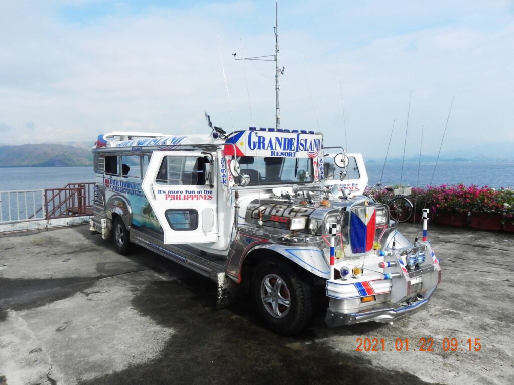 Zd860. I was surprised to see this jeepney on the old Fort Wint Pier/Wharf, which is now used by the Grande Island Resort. The resort greeted me with a welcome drink drove me to the reception. They offered to give me a ride here and there but I said: I’ll walk. 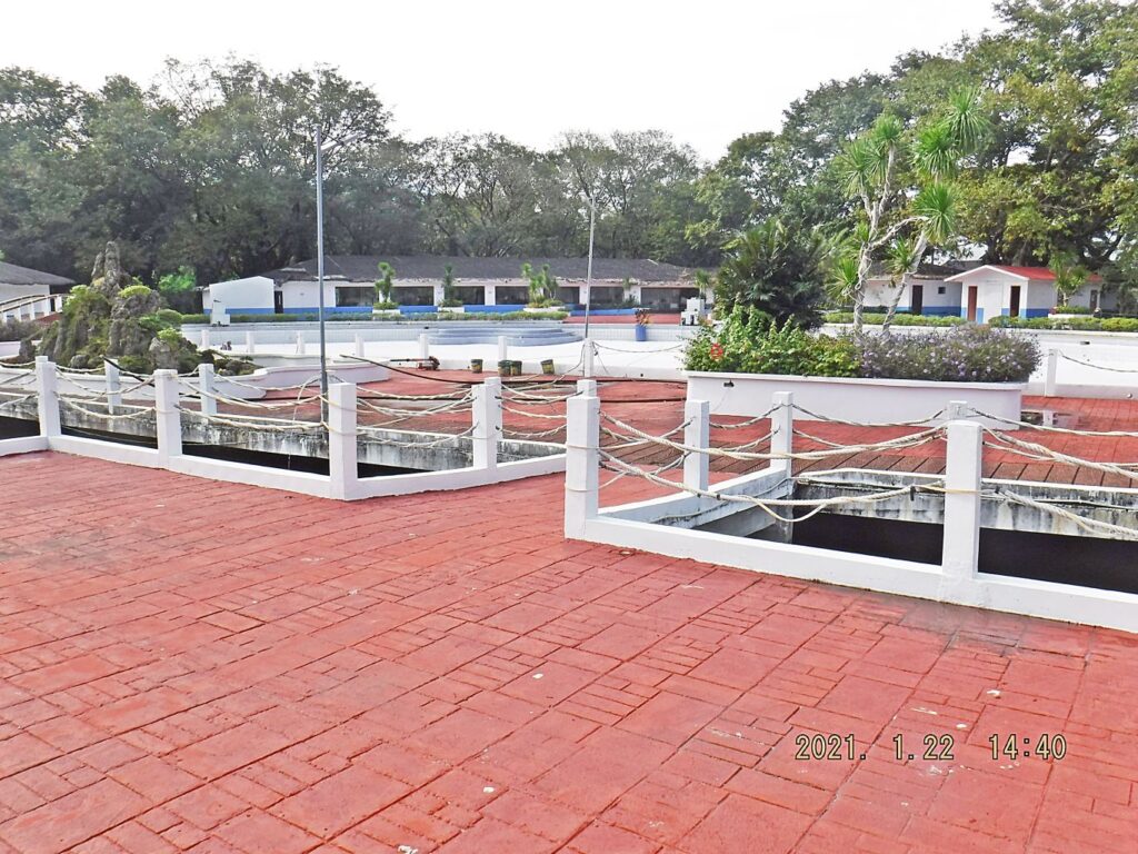 Zd861. I’m standing in the middle of the former Navy ball field on Grande Island, which are now a lagoon and a swimming pool. The building in back is the function structure, reception, dining hall etc. --------------------------------------- For your orientation I will present now some Grande Island/Fort Wint maps: 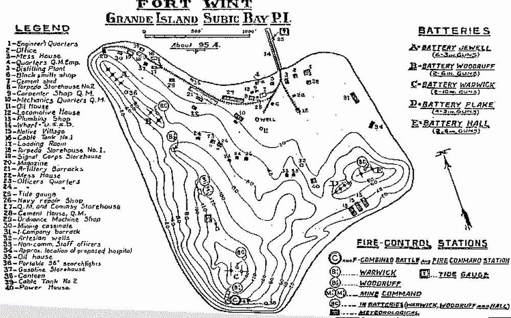 Zc294. A Fort Wint 1921 map. 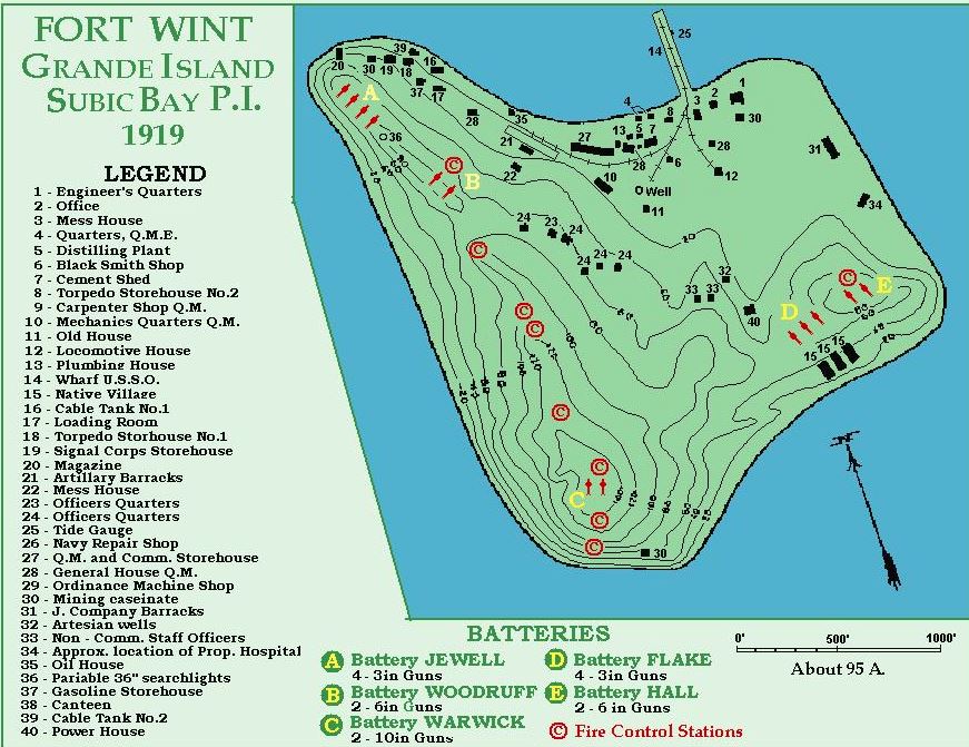 Zc285. Fort Wint-Grande Island 1919, this great drawing came from an U.S. Navy oiler ship web page. 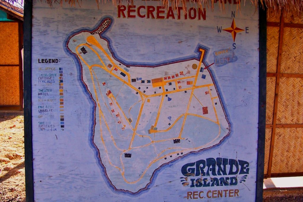 Za516. The Grande Island ex MWR map on a piece of plywood still existed in 2006. This Grande Island ex MWR map on a piece of plywood still existed in 2006. It was standing where the Navy cottages were and were the new cottages are now. But after 2006 it disappeared. MWR stands for Navy Morale, Welfare and Recreation Department. This is the unmarked copy. 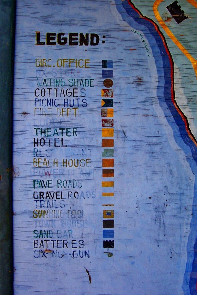 Za517. This is the Legend for the Grande Island ex MWR map on a piece of plywood in 2006. |
|
|
|
Post by Karl Welteke on Jan 21, 2021 12:29:19 GMT 8
Bataan Trip 15th Jan. 2021. The Surrender Marker of Gen. Wainwright In Cabcaben, at this spot Gen. Homma told Gen Wainwright surrender all his Forces in the Philippines or forget it; the Battle of Corregidor will continue. Gen. Wainwright had no choice; Washington had appointed him Overall Commander in the Philippines. That is exactly why Gen. MacArthur wanted to keep the Command and direct it now from Australia, so that Gen Wainwright only had authority over the Luzon Forces. Anyway, in a house at this spot, Gen. Wainwright was forced to surrender all of the Philippine Islands on the 6th of May 1942, and the painfully occupation of the Philippines begun and lasted until the so joyful liberation, about 2 ½ year later. While there, I met three young people and I asked them what they were doing. They said they were from the Provincial Government and were taking notes of the condition of the Marker/Memorial. Interesting, maybe something will come of it. The Marker/Memorial is in Filipino. This Marker/Memorial is located exactly in the fork, where the old National Road splits away from the post WWII, toll-free, Bataan Expressway to Mariveles. And it seems that the Barangay (Village) Cabcaben has split up, and now there are two Barangays now, Cabcaben and Townsite. 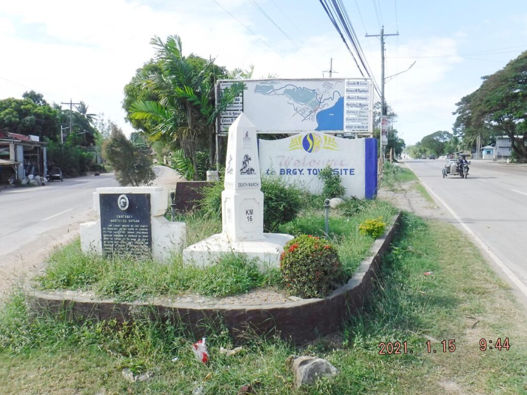 Zd851. This is one of 5 images of the Surrender Marker of Gen. Wainwright in Cabcaben/Townsite, shot on the 15th of Jan. 2021. It was built by the Philippine Authorities and is in Filipino. The # 16 Death March Marker is also located at this spot. Barangay Townsite has a welcome sign and village map on display. 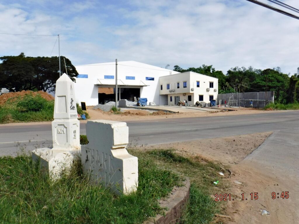 Zd852. This is one of 5 images of the Surrender Marker of Gen. Wainwright in Cabcaben/Townsite, shot on the 15th of Jan. 2021. It was built by the Philippine Authorities and is in Filipino. The # 16 Death March Marker is also located at this spot. Barangay Townsite has a welcome sign and village map on display. 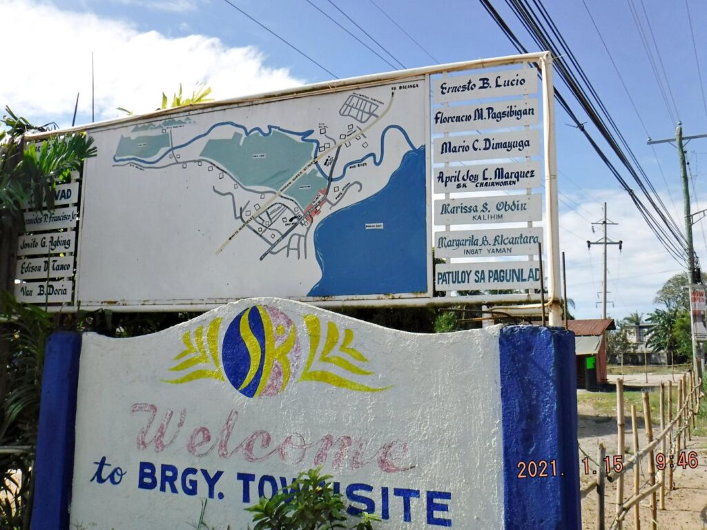 Zd853. This is one of 5 images of the Surrender Marker of Gen. Wainwright in Cabcaben/Townsite, shot on the 15th of Jan. 2021. It was built by the Philippine Authorities and is in Filipino. The # 16 Death March Marker is also located at this spot. Barangay Townsite has a welcome sign and village map on display. 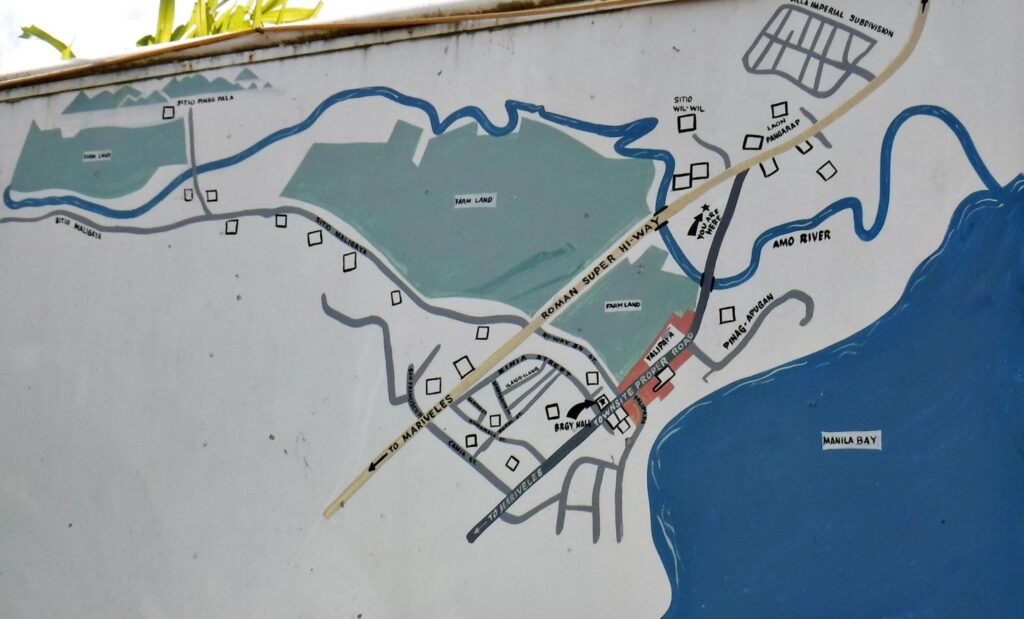 Zd854. This is one of 5 images of the Surrender Marker of Gen. Wainwright in Cabcaben/Townsite, shot on the 15th of Jan. 2021. It was built by the Philippine Authorities and isin Filipino. The # 16 Death March Marker is also located at this spot. Barangay Townsite has a welcome sign and village map on display. 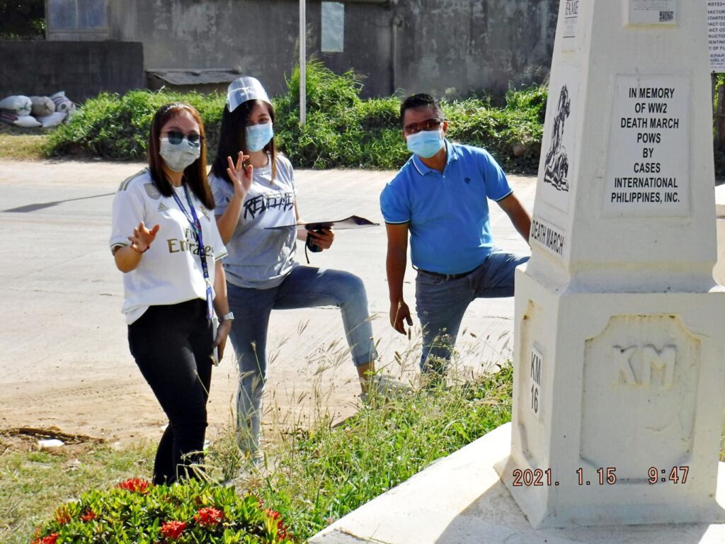 Zd855. This is one of 5 images of the Surrender Marker of Gen. Wainwright in Cabcaben/Townsite, shot on the 15th of Jan. 2021. It was built by the Philippine Authorities and is in Filipino. The # 16 Death March Marker is also located at this spot. Barangay Townsite has a welcome sign and village map on display. I actually made one album with all the venues of this trip into this album, but it is a long one: philippine-sailor.net/2021/01/19/bataan-trip-21-01-15/ |
|
|
|
Post by Karl Welteke on Jan 20, 2021 9:28:33 GMT 8
The Bataan Surrender Memorial in Lamao Bataan Trip 21-01-15. This was an exploration trip to look at changes in Bataan during the virus crisis; I had to get permission from my Barangay (Village) Captain, the Barangay Medical Department and the Olongapo Police Head Quarters. I have been absent from the Philippines for 15 months and we all have suffered from the Red China Virus for 9 months or so. What has changed in Bataan? My next stop was the municipality of Lamao I wanted to see the Bataan Surrender Memorial there. I knew that it was built by the Battlin Bastard of Bataan and they had a strong desire to build it there because that is where their General surrendered, not in Balanga! They always expressed the opinion that history shall be told accurately. I wanted to see how it looks now and it looks just fine, all the market vendors are gone and it has a secure open spot in a large sport complex in the center of village compound. I’m sure that makes the Battlin Bastard of Bataan happy, I think most of them are in Heaven now. It would be nice, if the authorities would fly both National Flags, at least on some important anniversary dates! Wikipedia says this about Lamao: en.wikipedia.org/wiki/Lamao,_Limay On April 9, 1942, under the Big Mulberry Tree in front of the old administration building, right in the heart of Lamao, Gen. Edward P. King, Jr. signed the official surrender paper of 78,000 soldiers of the USAFFE under him to Masahara Homma of the Japanese Imperial Army. Lamao is a barangay in Limay, Bataan, facing the Manila Bay in the Philippines. The population of Lamao is about 18,000, which made it the most populous barangay in Bataan. The current Barangay Chairman of Lamao is Restituto "Bart" Reyes. Lamao is the home of Camp General Antonio Luna which incorporates the Government Arsenal. 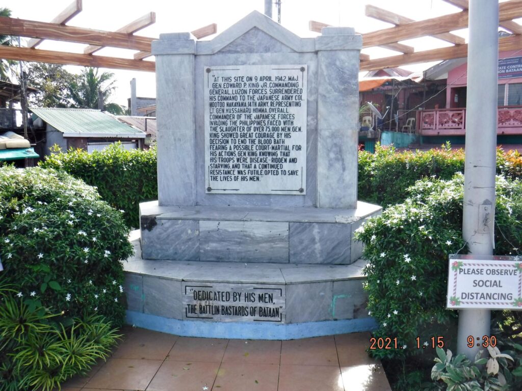 Zd847. This is one of 5 images of the Bataan Battle Surrender Memorial, in Lamao Bataan, shot on the 15th of Jan. 2021. It was built by the Battlin Bastards of Bataan with the proud consent of the people of Bataan. I started an album in my webpage but so far I only uploaded only the 6 pictures about the Subic Freeport Expressway and these 5 images about the Lamao Bataan Surrender Memorial. Uploaded to the Karl’s webpage, Central Luzon, Bataan No 1 subcategory, Bataan Trip 21-01-15: philippine-sailor.net/2021/01/19/bataan-trip-21-01-15/ |
|


