Kiangan, Ifugao, WWII History and Geography
To go there and learn about history, see the spectacular geography, know that this is the place where General Yamashita surrendered and this was the general area where the Japanese still had over 50,000 troop at the end of June 1945; THAT TO ME IS MOST INTERESTING!
Much of my presentation comes from this U.S. Army publication, below here:
Triumph in the Philippines, by Robert Ross Smith. OFFICE OF THE CHIEF OF MILITARY HISTORY. DEPARTMENT OF THE ARMY. WASHINGTON, D.C., 1993. Chapter XXIX, Pursuit in Northern Luzon.
www.ibiblio.org/hyperwar/USA/USA-P-Triumph/USA-P-Triumph-29.htmlI copied some of the paragraphs and maps from the above URL.
Sixth Army had greatly underestimated the Japanese strength left in northern Luzon, and Eighth Army's estimates, made upon its assumption of command, were but little closer to fact. Actually, at the end of June, close to 65,000 Japanese remained alive in northern Luzon, 13,000 of them in the Sierra Madre and 52,000 in the last-stand area between Routes 4 and 11. Although organization, control, and morale were deteriorating, and although most of the troops were ill armed and poorly supplied, the Japanese in the last-stand area were still capable of effective resistance when the occasion demanded. The task confronting the U.S. Army and guerrilla units in northern Luzon was of far greater magnitude than any headquarters estimated at the end of June.
On the east side of the Shobu Group's last-stand area, while the 6th Division was making its strongest effort an attack toward Kiangan, elements of the division struck north up Route 4 and reached Banaue on 20 July. Meanwhile, troops of the 11th Infantry, USAFIP(NL), had started south along Route 4 from Bontoc and on 21 July made contact with the 1st Infantry, 6th Division, at Polis Pass, five miles north of Banaue. This contact, coupled with that between USAFIP(NL) and 32d Division units on Route 11 eight days later, marked the complete encirclement of the Shobu Group last-stand area.
Throughout July and the first half of August the main effort continued to be the 6th Division's attack from Route 4 toward Kiangan. Here, all operations were virtually stopped about 1 July by incessant, torrential rains that turned the road toward Kiangan into an impassable quagmire. The problems of the 6th Division were aggravated because the Fifth Air Force, in "co-operation" with the Japanese, had made a shambles of sections of the old road, destroying all bridges and causing many landslides. Finally, rear-guard troops of the 105th Division also slowed progress.
The 63d Infantry, 6th Division, reached Kiangan on 12 July, there capturing all types of Japanese military supplies in large quantities. But then even heavier rains came down, and from 16 through 20 July the regiment was marooned at Kiangan, barely supported by hand-carrying parties. On the 24th, the 20th Infantry took over and began an advance toward Kiangkiang and the Asin River, simultaneously sending one battalion south from Kiangan toward Tubliao and the remnants of the 2d Tank Division.
Meanwhile, the Japanese had bitterly opposed the 6th Division's efforts to advance west from Kiangan toward the Asin Valley. Instead of mopping up, the division soon found itself involved in mountain fighting as rough as that experienced at any time or at any place throughout the Luzon Campaign, At the end of hostilities on 15 August the 20th Infantry, 6th Division, was scarcely three miles beyond Kiangan along the trail to Kiangkiang.
In a month and a half of bitter fighting in incredibly steep terrain and in the most miserable type of weather Fil-American forces had failed to project any strength into the Asin Valley. This last month and a half of the operation in northern Luzon had cost the forces engaged approximately 1,650 casualties, divided as follows:
Unit Killed Wounded Total
USAFIP(NL) 285 715 1,000
6th Division 45 190 235
32d Division 45 140 185
37th Division 50 130 180
Other 15 35 50
Total 440 1,210 1,650
Eighth Army estimated that Shobu Group casualties for the same period were 13,500 men killed or dead of starvation and disease.
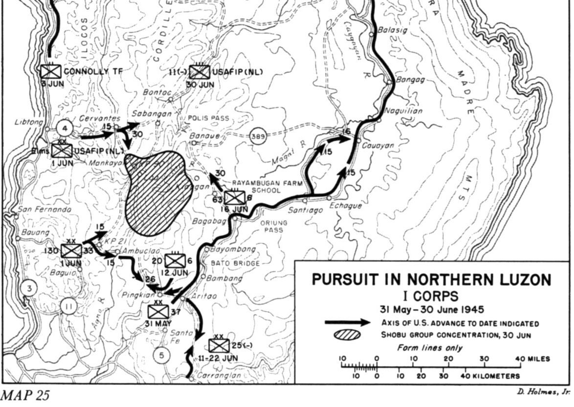
Z025. This map is from the above URL: Map 25. Pursuit in Northern Luzon. I Corps. 31 May-30 June 1945
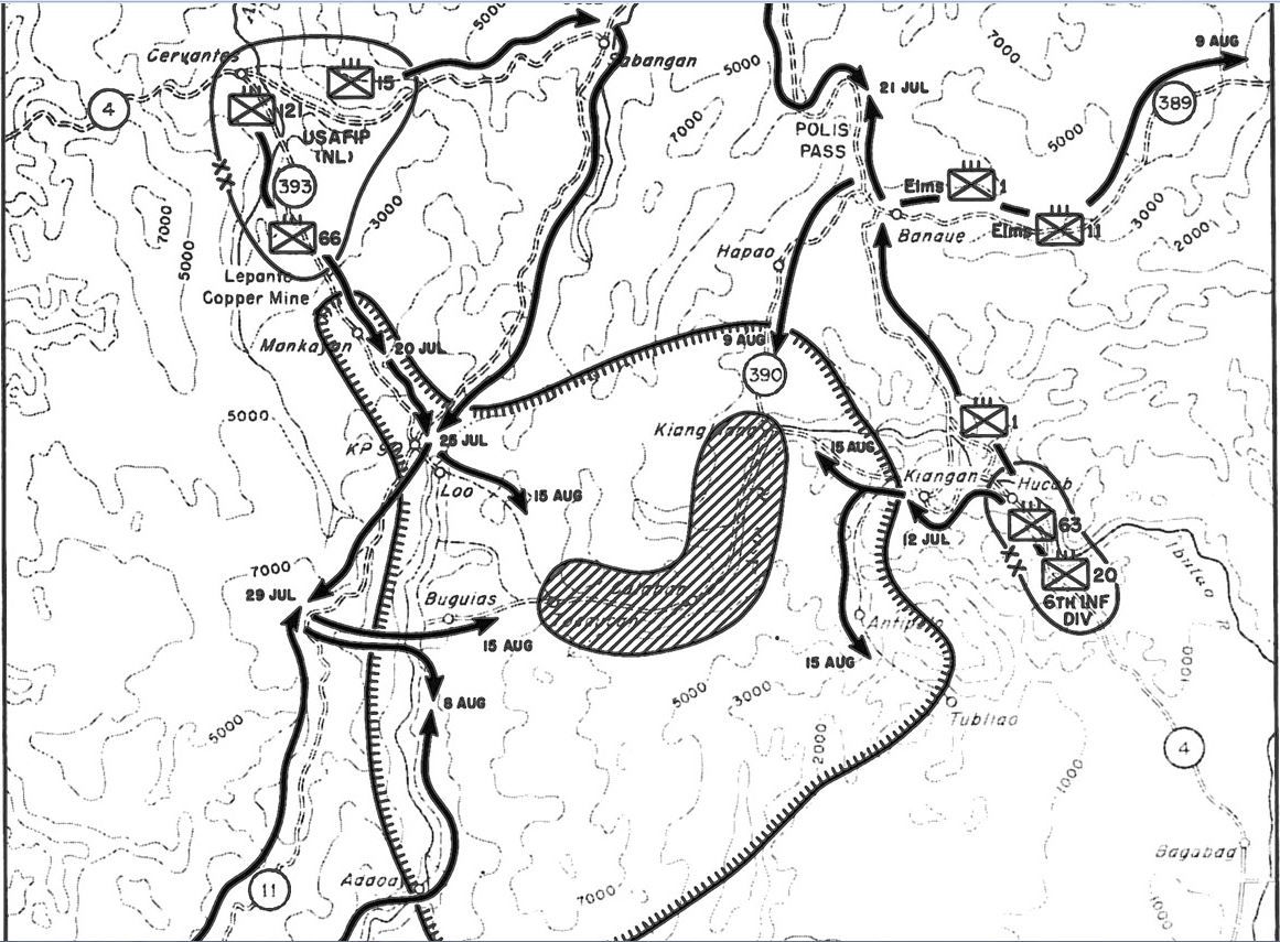
Z026. This map is from the above URL: Map 26; Final Operations in Northern Luzon; XIV Corps. 1 July-15 August 1945.
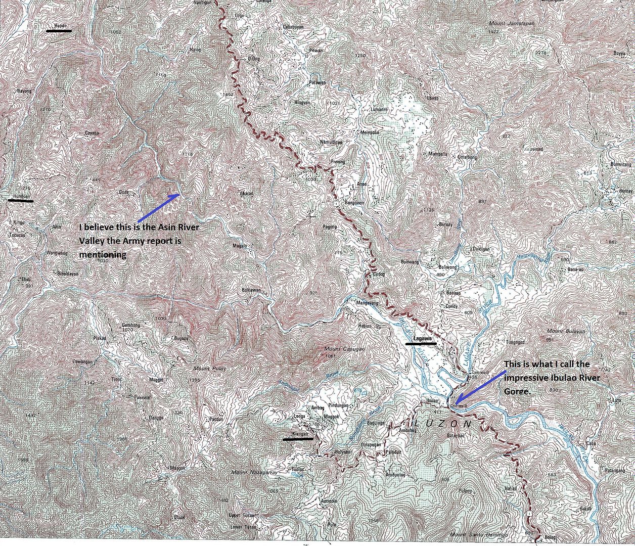
Z027. This is a section of a 1:50000 old map, No. 7276-IV. All the new roads, I traveled on, are not on it! I underlined Kiangan (surrender site), Hungduan (Gen Yamashita’s Command Post). Lagawe-because of the impressive Ibulao River Gorge and the famous Hapao rice terraces, a road goes thru it to Hungduan now.
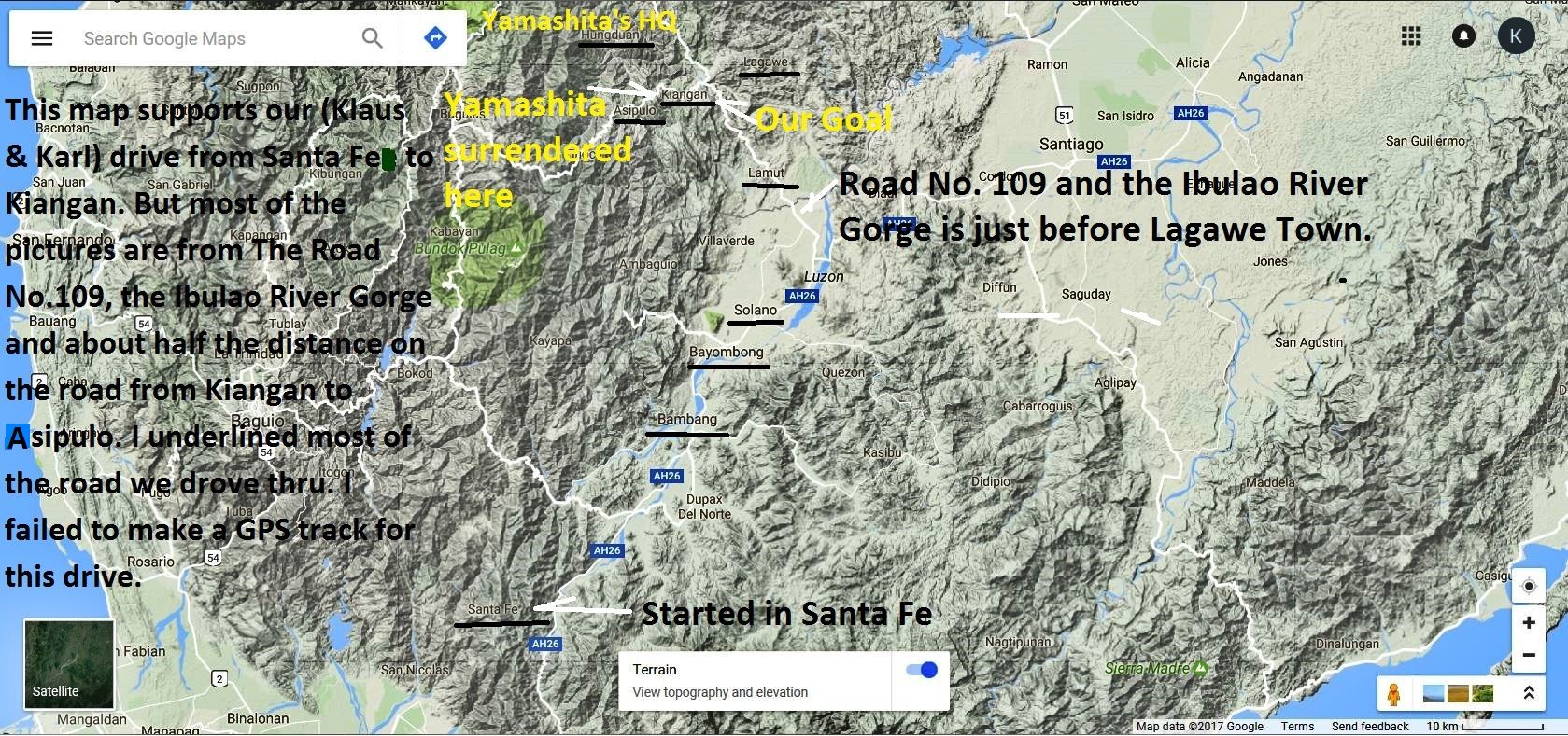
Z028. From my last visit to Kiangan I established an album. I linked it in this thread several times already. To me it is interesting because it shows how this area, how this province looks like. You may be interested to look or not, but here is the Google map for your orientation is this album URL:
app.photobucket.com/u/PI-Sailor/a/544de847-793c-40ea-8eaa-e958cb339631These 1st 12 images are vista shots on the road No. 109 towards Lagawe, we are entering Ifugao Land. The campaign picture of the Congressman caught my eye. I saw him on TV several times.
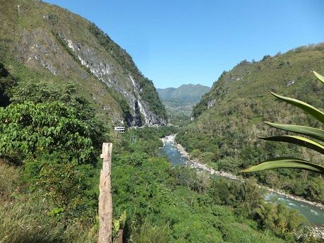
Z029. The next 6 images describe the Ibulao River Gorge, just downstream from Lagawe; these geological views always interest me. We were coming from the Cagayan River Valley.
The next 2 images; after we drove thru the Ibulao River Gorge, we did not turn right, that is the direction to Lagawe; we turned left going up to Kiangan. Looking back we have this view of the large Lagawe Basin.
The next 23 images description:
We drove thru Kiangan to explore the road further as it runs west towards Tinoc and Buguias. We did not even get to the next village Asipulo but the views were great and we took these pictures. We were on the south side of this valley so all the shots are to the north, sometime east or west. Imagine that Gen. Yamashita came from the north, from Hungduan, he cam down from somewhere up there. Just 2 sample images follow here:
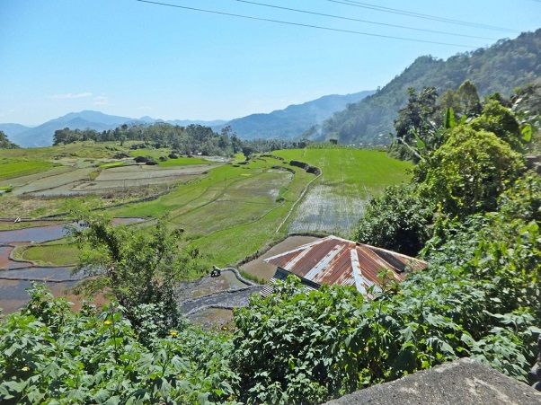
Z030.
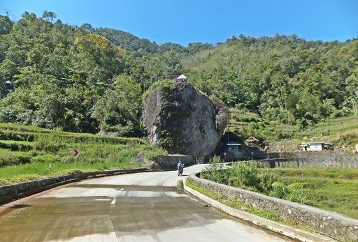
Z031.
The next 12 images description:
One of 12 pisc at the Kiangan Shrine, my friend looked around the shrine but I looked at the pictures in the Shrine Admin Building and tried to take pictures of the images displayed on the wall but I had trouble with light reflection. Presented in the thread earlier.
The next 6 images description:
One of 6 images at the actual initial, informal surrender site where Gen Yamashita appeared to give up his forces under the Emperor’s order. Presented in the thread earlier.
The last 7 images description:
One of 7 images, to look at the actual surrender site of Gen. Yamashita was the main purpose of visiting Kiangan again. It is located at the large Kiangan School compound, we got permission and had a look and took these pictures. Presented in the thread earlier.