|
|
Post by Karl Welteke on Jun 11, 2015 14:55:33 GMT 8
I hate to start too many new threads and will put any odd items into this one.
|
|
|
|
Post by Karl Welteke on Jun 11, 2015 15:42:57 GMT 8
CABLE-HUT NO 11 ON FORT MILLS, CORREGIDOR ISLAND This cable-hut is located next (SW side) of the present road to Battery Morrison and it was not too far from Barrio Lourdes. On the 13th April 2015 Glen and I were leaving Battery Morrison, riding a jeep as passengers, we seen this big concrete structure and steps leading underground. We checked it out and it was Cable-Hut #11. It is an elaborate structure which deserves some mentioning. I made an album with those pictures from that day. 12 images are in this URL: s74.photobucket.com/user/PI-Sailor/library/Corregidor%20by%20subject/Morrison%20Hill/Cable-Hut%20No%2011?sort=9&page=1or tinyurl.com/o66xb96Here are 7 sample images from that album but the images here are much smaller. 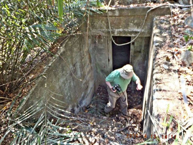 X537. This is the entrance to the Cable-Hut No. 11 next to the present road to Battery Morrison, on the former Fort Mills, Corregidor Island. 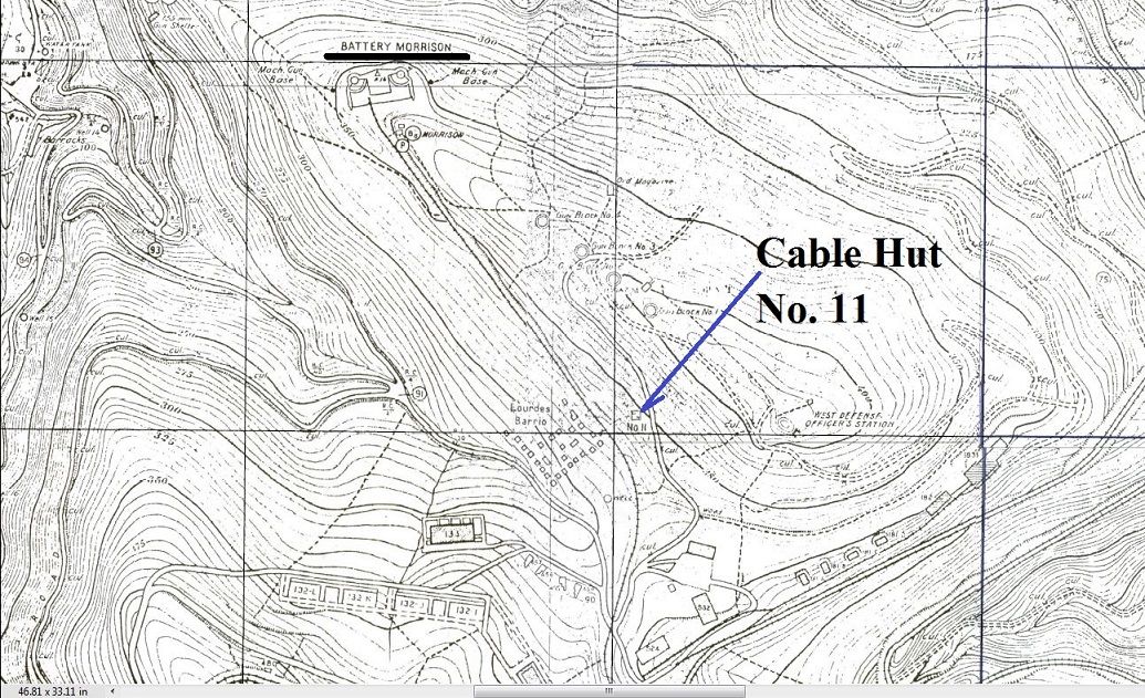 X538. A Corregidor map showing Cable-Hut #11 near the former Barrio Lourdes. It is now next to the present road (SW side) to Battery Morrison, on the former Fort Mills, Corregidor Island. 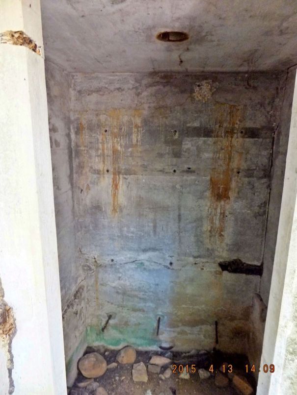 X539. This is the main room of the Cable-Hut No. 11, when you walk down the steps and enter this is what you see. 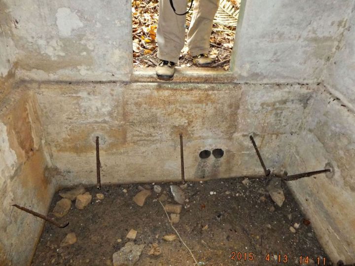 X540. This is the main room of the Cable-Hut No. 11, Glen just came down those steps to the Cable-Hut #11 next to the road to Battery Morrison, we see the two cable run holes enter the hut under the door to the main room of the cable-hut. 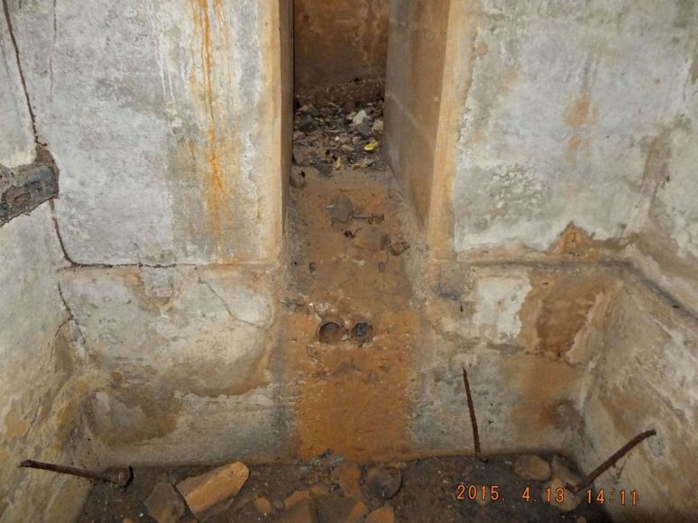 X541. From the main room in the Cable-Hut #11 a narrow small passage leads to another space towards the road. I did not try to enter; my waist or butt may have been too large. 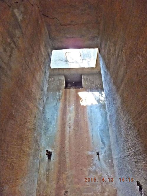 X542. This is an even closer look from the main room in Cable-Hut #11 thru the narrow passage into another space towards the road. 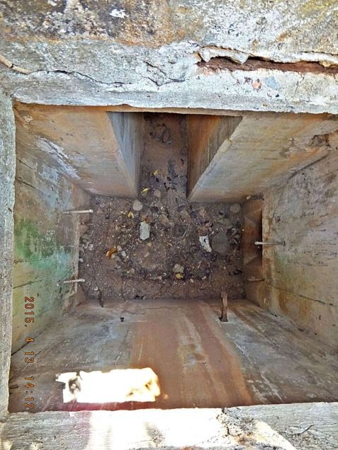 X543. The other room in the Cable-Hut #11 is closer to the Battery Morrison road and it is open on top, so this shot is straight down. At bottom right one can see where the cables continue towards the battery. |
|
|
|
Post by fireball on Jun 11, 2015 17:19:26 GMT 8
A question for you Karl as a man who must know Corregidor as well or, as I think likely, better than any other man who is not a scrapper:
Do you think there are some undiscovered structures still to be found ?
Certainly on both Fort Wint and Frank there are distinctive structures (by this i mean actual constructions rather than small indents or blocks of concrete) which exist but are not on any plans or maps and are not widely known about. Corregidor has received far more scrutiny than these two forts but then Corregidor through its size (and importance) has the ability to hide far more.
Just wondering ...
|
|
|
|
Post by Karl Welteke on Jun 11, 2015 18:14:24 GMT 8
Hey fireball
I think small structures like this Cable-Hut 11 are possible. I think I would put fots2 a couple notches higher than me. He works more thoroughly and does more planning beforehand at least on Corregidor.
|
|
|
|
Post by Karl Welteke on Nov 2, 2015 18:59:46 GMT 8
AERIAL 1923 IMAGES OF FORT MILLS ON CORREGIDOR ISLAND After I posted all the aerial shots of the other 4 forts and islands it is now Corregidor’s turn. This high resolution image was given to me by Karl Schmidt from the CDSG who got the image from NARA. This is a start only. The original image was cropped 9 times and all 10 images were snipped (Window tool) which is like taking a screen shot of the original images and you get a great reduced byte count but the picture still looks the same. None of the pictures in the Flickr album were reduced in size. So, it is like I zoomed in at 9 places on the original image. This image and the 9 crops are unloaded into this Flickr album, called: “Aerial views from NARA via CDSG”. They are numbered F1 to F10 and are in the below album. www.flickr.com/photos/44567569@N00/albumsThe same 10 images are presented here in the forum but are smaller: 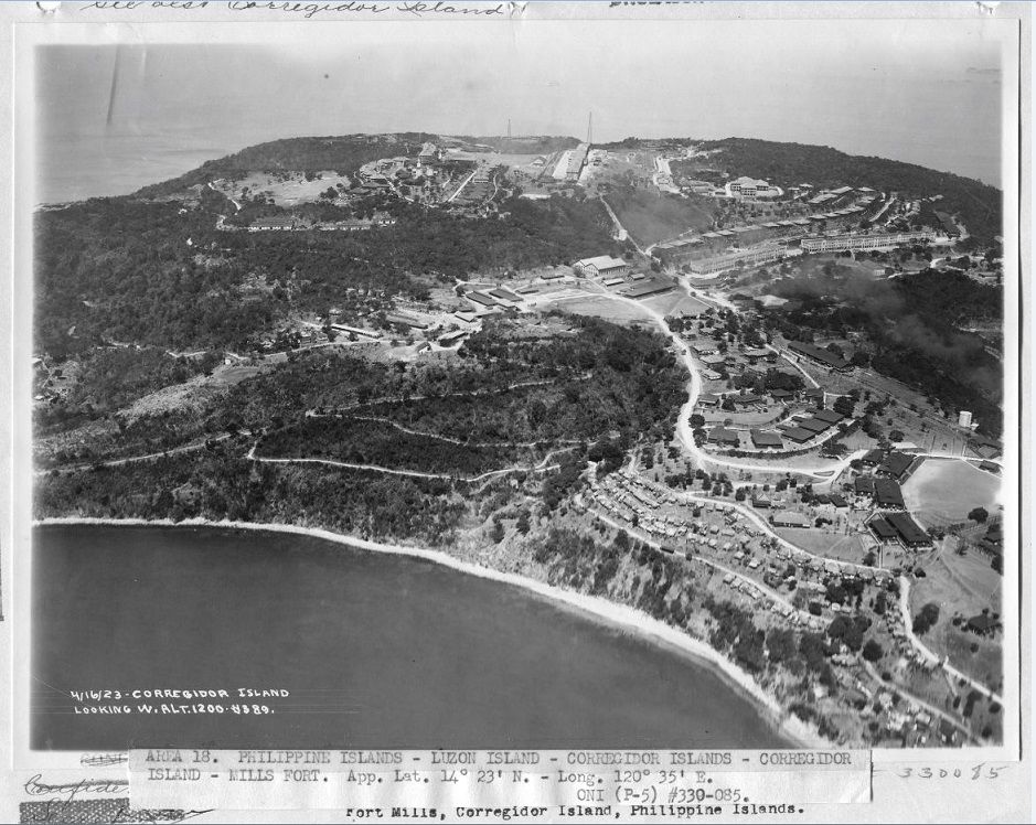 W280 (F1) US Army aerial image of Fort Mills on Corregidor Island 1923-04-16 centered on Middleside. This picture was attained by Karl Schmidt of Coastal Defense Study Group (cdsg.org) who got it from the National Archives and Record Administration (NARA). 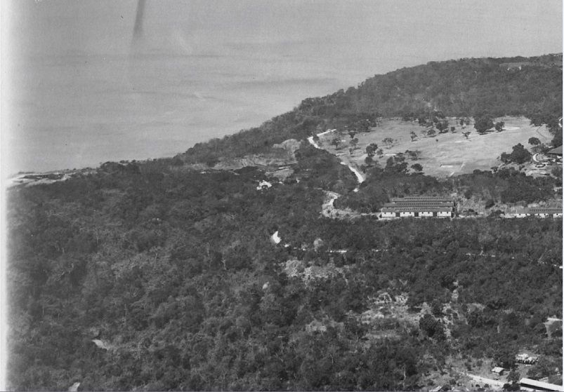 W281 (F2) US Army aerial image of Fort Mills on Corregidor Island 1923-04-16; this is the area south of the golf course. This is a cropped portion from the image F1 above. This picture was attained by Karl Schmidt of Coastal Defense Study Group (cdsg.org) who got it from the National Archives and Record Administration (NARA). 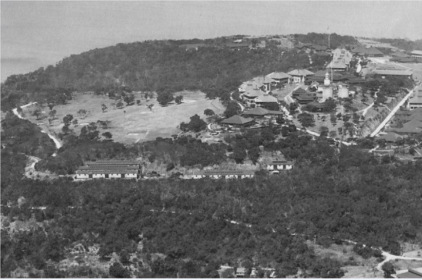 W282 (F3) US Army aerial image of Fort Mills on Corregidor Island 1923-04-16; this is the golf course Topside. This is a cropped portion from the image F1 above. This picture was attained by Karl Schmidt of Coastal Defense Study Group (cdsg.org) who got it from the National Archives and Record Administration (NARA). 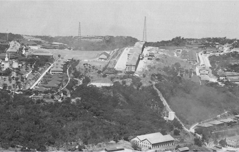 W283 (F4) US Army aerial image of Fort Mills on Corregidor Island 1923-04-16; this is the parade ground Topside. This is a cropped portion from the image F1 above. This picture was attained by Karl Schmidt of Coastal Defense Study Group (cdsg.org) who got it from the National Archives and Record Administration (NARA). 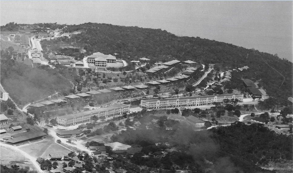 W284 (F5) US Army aerial image of Fort Mills on Corregidor Island 1923-04-16; this is the hospital between Topside and Middleside. This is a cropped portion from the image F1 above. This picture was attained by Karl Schmidt of Coastal Defense Study Group (cdsg.org) who got it from the National Archives and Record Administration (NARA). 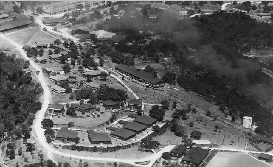 W285 (F6) US Army aerial image of Fort Mills on Corregidor Island 1923-04-16; this is centered on the Nipa Hut area on Middleside. This is a cropped portion from the image F1 above. This picture was attained by Karl Schmidt of Coastal Defense Study Group (cdsg.org) who got it from the National Archives and Record Administration (NARA). 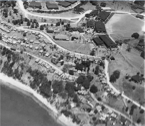 W286 (F7) US Army aerial image of Fort Mills on Corregidor Island 1923-04-16; this is the Conception Barrio and the NCO Quarters on the Stockade Level. This is a cropped portion from the image F1 above. This picture was attained by Karl Schmidt of Coastal Defense Study Group (cdsg.org) who got it from the National Archives and Record Administration (NARA). 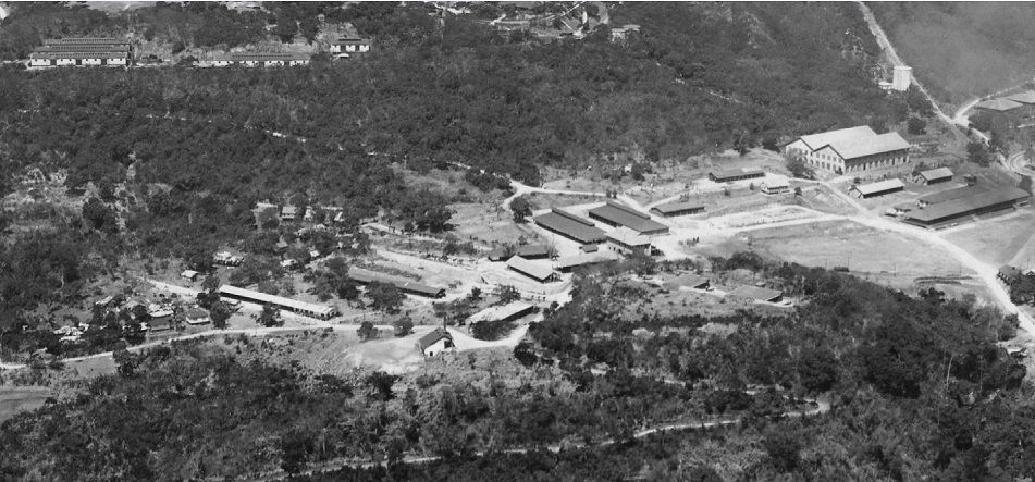 W287 (F8) US Army aerial image of Fort Mills on Corregidor Island 1923-04-16; this is the stables area on Middleside. This is a cropped portion from the image F1 above. This picture was attained by Karl Schmidt of Coastal Defense Study Group (cdsg.org) who got it from the National Archives and Record Administration (NARA). 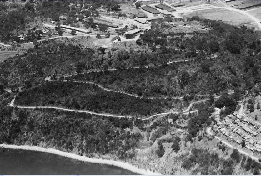 W288 (F9) US Army aerial image of Fort Mills on Corregidor Island 1923-04-16; this is below the stables and the Ramsey Ravine below Middleside. This is a cropped portion from the image F1 above. This picture was attained by Karl Schmidt of Coastal Defense Study Group (cdsg.org) who got it from the National Archives and Record Administration (NARA). 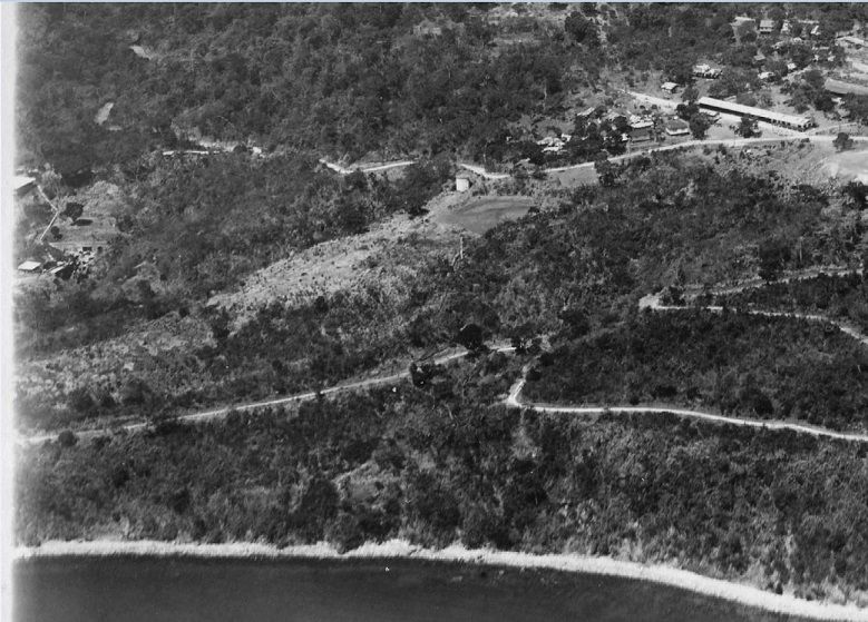 289 (F10) US Army aerial image of Fort Mills on Corregidor Island 1923-04-16; this is the Government Vault at left below Middleside. This is a cropped portion from the image F1 above. This picture was attained by Karl Schmidt of Coastal Defense Study Group (cdsg.org) who got it from the National Archives and Record Administration (NARA). |
|
|
|
Post by steveontherock on Nov 2, 2015 22:09:28 GMT 8
Karl
These are absolutely fantastic images. Having lived on Middleside for over six and a half years, it's amazing how many things were right in our neighborhood. There's a lot of evidence of some of these buildings, but it's amazing how much is gone as well. Thanks for taking the time to crop and post.
Steve Kwiecinski *formerly "Steve on the Rock"
|
|
|
|
Post by fortman on Nov 2, 2015 22:48:03 GMT 8
I agree with Steve! Looking forward to the rest.
fortman
|
|
|
|
Post by okla on Nov 3, 2015 4:05:25 GMT 8
Hey Steve....I agree that so many of the 1920s structures, facilities, etc were eliminated/removed prior to the outbreak of war. If memory serves, by the Summer of 1941, extensive "remodeling", for lack of a better word, had taken place. Maybe "stripping down" for War would be the proper descriptive word. Just sayin". Postscript...Also, by 1941, some of that 1920s vegetation could, possibly, be shielding many of the smaller structures, and they do not appear in the more modern aerial surveys taken just prior to Pearl Harbor. Again, just sayin'.
|
|
|
|
Post by okla on Nov 3, 2015 4:06:31 GMT 8
Hey Steve....I agree that so many of the 1920s structures, facilities, etc were eliminated/removed prior to the outbreak of war. If memory serves, by the Summer of 1941, extensive "remodeling", for lack of a better word, had taken place. Maybe "stripping down" for War would be the proper descriptive word. Just sayin". Postscript...Also, by 1941, some of that 1920s vegetation could, possibly, be shielding many of the smaller structures, and they do not appear in the more modern aerial surveys taken just prior to Pearl Harbor. Again, just sayin'.
|
|
|
|
Post by okla on Nov 3, 2015 4:11:34 GMT 8
Hey Karl.....Excellent material, as per usual. I, especially, enjoy "now and then" pics or shots, such as these, that can be compared with others that already appear on this Forum. Thanks for posting. Cheers.
|
|


