


Signal Hill played a role in the Battle of Bataan.
Mar 14, 2018 17:19:06 GMT 8
victor, chadhill, and 1 more like this
Post by Karl Welteke on Mar 14, 2018 17:19:06 GMT 8
Signal Hill played a role in the Battle of Bataan.
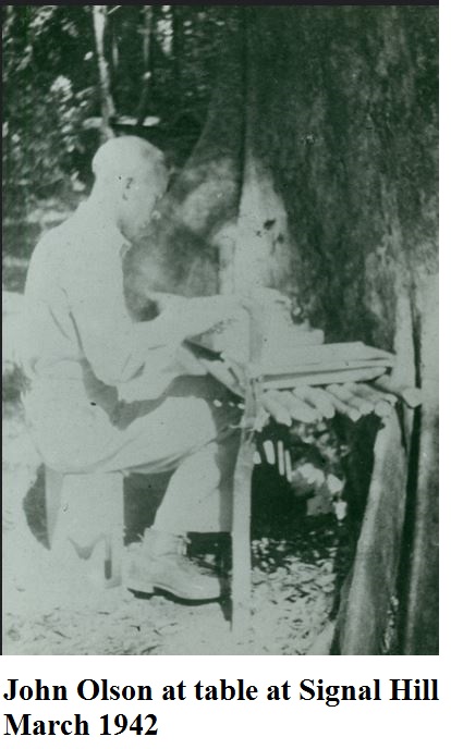
Za696. Lt. Olson at a table on Signal Hill, March 1942.
Lt. Olson at a table on Signal Hill, March 1942, maybe he held a higher rank at that time. This picture came from a Flickr album called: Colonel John Olson, West Point, Graduate
57th Regiment Philippine Scouts. This is the URL: He is also one of my heroes!
www.flickr.com/photos/american_defenders_of_bataan_and_corregidor_museum/sets/72157629786139628/
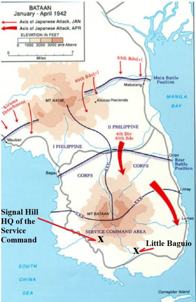
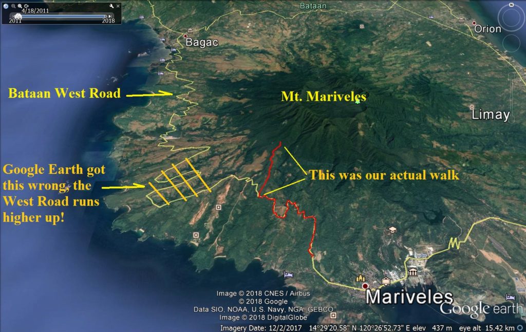
Za697. Map locations of Signal Hill and Little Baguio.
I marked in the two locations, Signal Hill and Little Baguio, because I learned that they were at those locations.
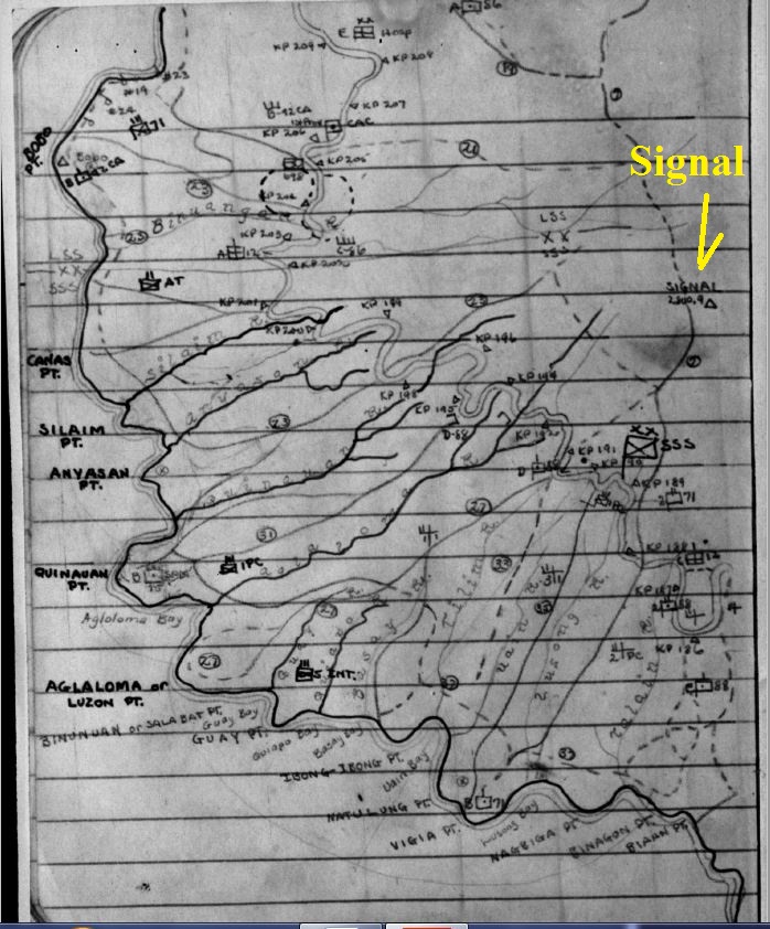
Za698. WWII SW Bataan Hand drawn map from Philippine Veterans Affairs Office (PVAO).
This confirmed that the location “Signal or Signal Hill” existed. Look close and you can see that Trail #7 starts there!
The Philippine Veterans Affairs Office (PVAO) has a Philippine Archives Collection
The Philippine Archives Collection is a group of records at the US National Archives that constitutes an invaluable source of information on the Pacific war, particularly concerning the treatment of prisoners of war (POWs); military operations in the Philippines, 1941-1942; guerrilla warfare in the Philippines; and conditions in the Philippines under Japanese occupation.
This is the URL:
collections.pvao.mil.ph/
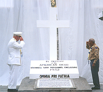
Za699. Camp O'Donnell Memorial. Maj. Richard Gordon and Phil Coon unveiling the Cross. This is a BBB image.
Major Richard Gordon is my hero and he led the Battling Bastards of Bataan (BBB) for a long time and on the above picture he helps unveil the Camp O’Donnell Memorial at the Capas Shrine. He spoke of the Signal Hill in this interview:
World War II: Interview with Major Richard M. Gordon — Bataan Death March Survivor
www.historynet.com/world-war-ii-interview-with-major-richard-m-gordon-bataan-death-march-survivor.htm
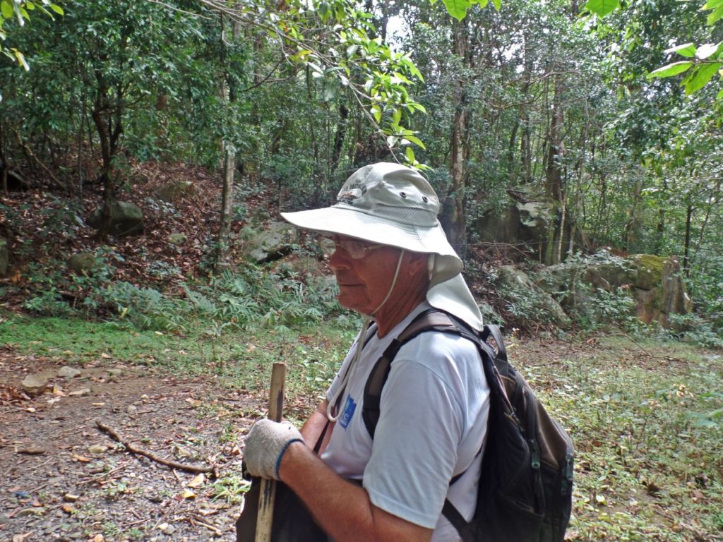
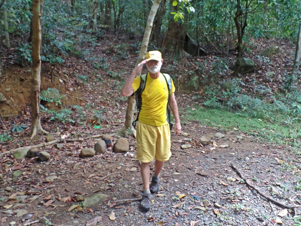
Za700. Karl-Wilhelm Welteke walking on the Signal Hill Road (SW Bataan) in 2018. Image is from Harald Klose.
Many years ago I walked in this area and I asked the locals where this road goes to. They answered: “To the Signal Hill”. That surprised me, I never heard of it but I immediately thought there must be a WWII connection.
Later I read in a WWII book that the Service Command Area Head Quarter was located here but because of the Battle of the Points it was moved to the Little Baguio Area.
Ever since then I wanted to have a look at this area and finally in Feb. 2018 friends and I did!
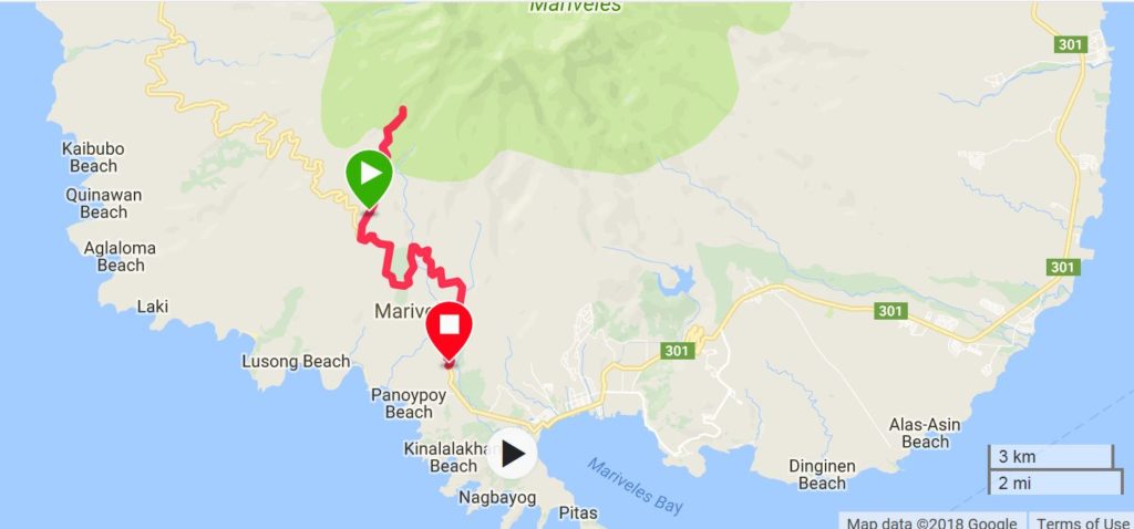
Za701. Signal Hill Road GPS track, SW Bataan, 2018-02-08
This is my GPS track of our walk on the Signal Hill Road at SW Bataan. Due to Operator error I had to restart it and I forgot to save the track until we returned down, almost back in Mariveles with our car.
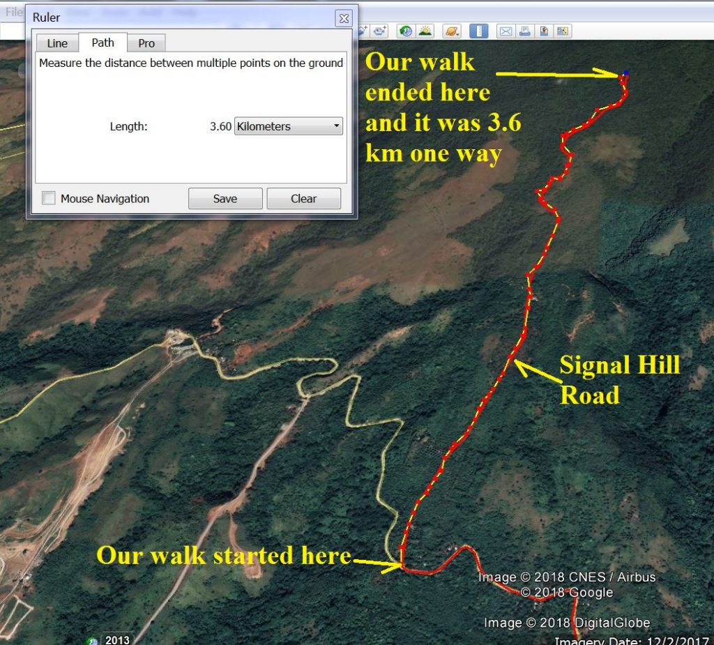
Za702. Signal Hill Road Walking GPS track, SW Bataan, 2018-02-08
I traced the walking portion of the track with Google Earth and it is 7.2 km round trip.
Za703. Signal Hill Road Walking GPS track, SW Bataan, on a Garmin terrain map, 2018-02-08.
I add this Garmin terrain map because it shows some geographic names of the Battle of the Points area. It also shows that I had to restart my GPS device again and late and that I did not turn it off until too late.
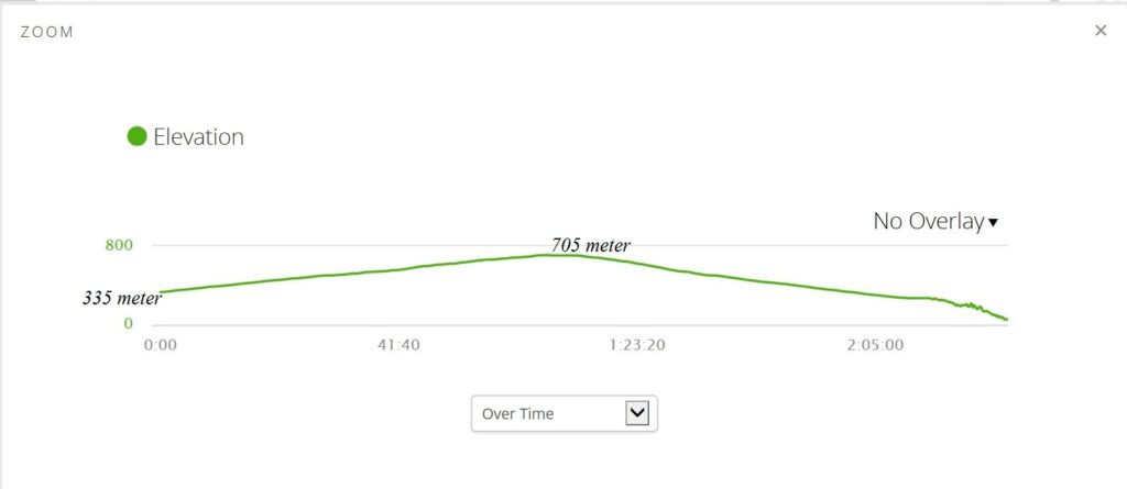
Za704. Signal Hill Road Walk GPS track and elevation profile, SW Bataan, 2018-02-08.
Za705. Kent Blythe on the Signal Hill Road, SW Bataan, 2018-02-08.
Kent was one of my partners today. He is a Naval Academy Graduate and lives, like me, in Subic Bay. He is 70 and walks circles around me, he walked backwards up the trail, run down passed me a stretch and then overtook me again, so I am way too slow for him!
My other partner was the retired Colonel of the German Army, Harald Klose, a family friend, who has explored Philippine history with me, now for the fifth year. He is 78, two years older than me, and also walks faster than me. He took the pictures and did not get on one.
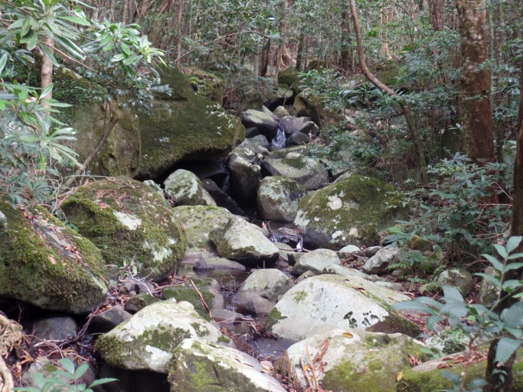
Za706. The Signal Hill Road at South West Bataan ends here at this mountain creek, photo from Harald Klose on 2018-02-08.
The road was an exceptional good gravel road and 3.6 km long. In the beginning it had concrete drain ditches on either side, later only on the south side. This same road, at the bottom where it intersects with the Bataan West Road, a few meters away the road to Lusong Beach starts. I have to walk it some time. Houses are now being build and San Miguel Corp.has a guard watching a large lot of land, I’m sure they have future plans.
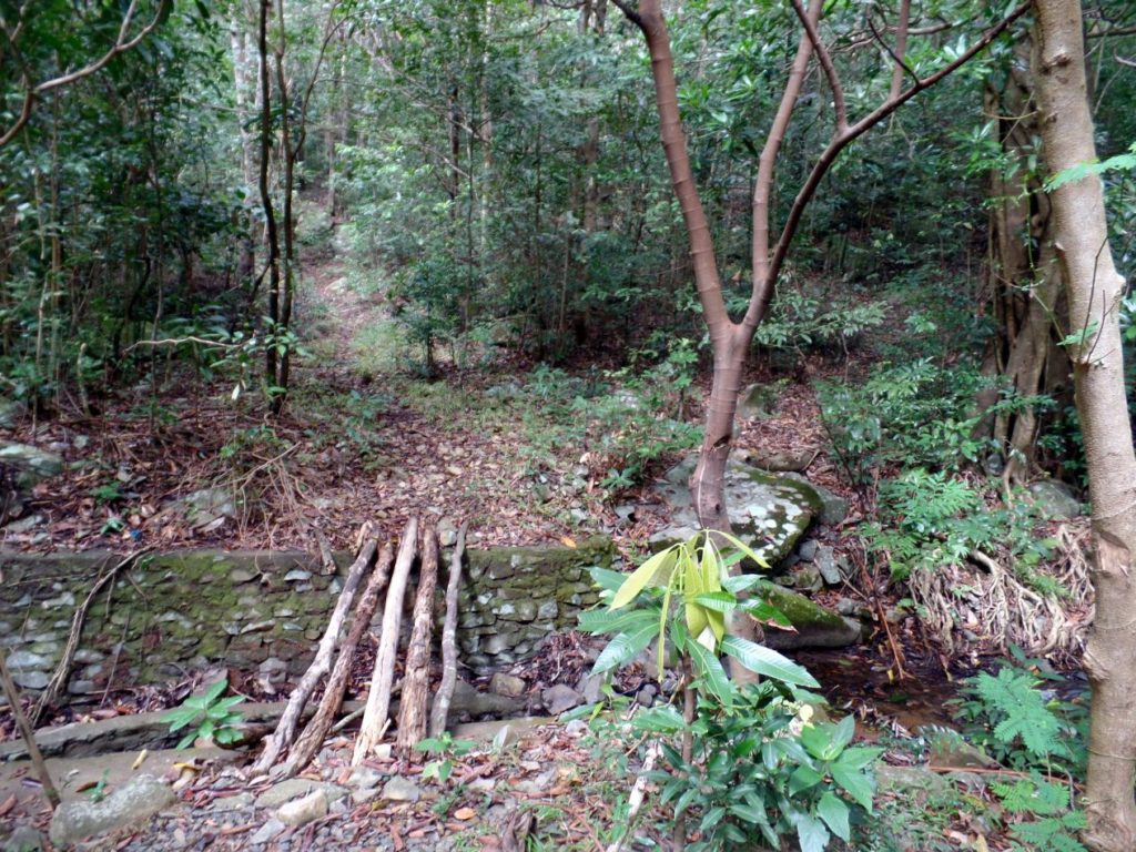
Za707. The Signal Hill Road at South West Bataan ends here at this mountain creek, photo from Harald Klose on 2018-02-08.
I am speculating that at this point Trail # 7 starts; we did not check it out. Trail #7 runs along the high slopes of Mt. Mariveles (the closest peak is called Mt. Bataan and is mentioned so in many WWII books). Trail # 7 runs all the way to the Bagac-Pilar Road.
Za696. Lt. Olson at a table on Signal Hill, March 1942.
Lt. Olson at a table on Signal Hill, March 1942, maybe he held a higher rank at that time. This picture came from a Flickr album called: Colonel John Olson, West Point, Graduate
57th Regiment Philippine Scouts. This is the URL: He is also one of my heroes!
www.flickr.com/photos/american_defenders_of_bataan_and_corregidor_museum/sets/72157629786139628/
Za697. Map locations of Signal Hill and Little Baguio.
I marked in the two locations, Signal Hill and Little Baguio, because I learned that they were at those locations.
Za698. WWII SW Bataan Hand drawn map from Philippine Veterans Affairs Office (PVAO).
This confirmed that the location “Signal or Signal Hill” existed. Look close and you can see that Trail #7 starts there!
The Philippine Veterans Affairs Office (PVAO) has a Philippine Archives Collection
The Philippine Archives Collection is a group of records at the US National Archives that constitutes an invaluable source of information on the Pacific war, particularly concerning the treatment of prisoners of war (POWs); military operations in the Philippines, 1941-1942; guerrilla warfare in the Philippines; and conditions in the Philippines under Japanese occupation.
This is the URL:
collections.pvao.mil.ph/
Za699. Camp O'Donnell Memorial. Maj. Richard Gordon and Phil Coon unveiling the Cross. This is a BBB image.
Major Richard Gordon is my hero and he led the Battling Bastards of Bataan (BBB) for a long time and on the above picture he helps unveil the Camp O’Donnell Memorial at the Capas Shrine. He spoke of the Signal Hill in this interview:
World War II: Interview with Major Richard M. Gordon — Bataan Death March Survivor
www.historynet.com/world-war-ii-interview-with-major-richard-m-gordon-bataan-death-march-survivor.htm
Za700. Karl-Wilhelm Welteke walking on the Signal Hill Road (SW Bataan) in 2018. Image is from Harald Klose.
Many years ago I walked in this area and I asked the locals where this road goes to. They answered: “To the Signal Hill”. That surprised me, I never heard of it but I immediately thought there must be a WWII connection.
Later I read in a WWII book that the Service Command Area Head Quarter was located here but because of the Battle of the Points it was moved to the Little Baguio Area.
Ever since then I wanted to have a look at this area and finally in Feb. 2018 friends and I did!
Za701. Signal Hill Road GPS track, SW Bataan, 2018-02-08
This is my GPS track of our walk on the Signal Hill Road at SW Bataan. Due to Operator error I had to restart it and I forgot to save the track until we returned down, almost back in Mariveles with our car.
Za702. Signal Hill Road Walking GPS track, SW Bataan, 2018-02-08
I traced the walking portion of the track with Google Earth and it is 7.2 km round trip.
Za703. Signal Hill Road Walking GPS track, SW Bataan, on a Garmin terrain map, 2018-02-08.
I add this Garmin terrain map because it shows some geographic names of the Battle of the Points area. It also shows that I had to restart my GPS device again and late and that I did not turn it off until too late.
Za704. Signal Hill Road Walk GPS track and elevation profile, SW Bataan, 2018-02-08.
Za705. Kent Blythe on the Signal Hill Road, SW Bataan, 2018-02-08.
Kent was one of my partners today. He is a Naval Academy Graduate and lives, like me, in Subic Bay. He is 70 and walks circles around me, he walked backwards up the trail, run down passed me a stretch and then overtook me again, so I am way too slow for him!
My other partner was the retired Colonel of the German Army, Harald Klose, a family friend, who has explored Philippine history with me, now for the fifth year. He is 78, two years older than me, and also walks faster than me. He took the pictures and did not get on one.
Za706. The Signal Hill Road at South West Bataan ends here at this mountain creek, photo from Harald Klose on 2018-02-08.
The road was an exceptional good gravel road and 3.6 km long. In the beginning it had concrete drain ditches on either side, later only on the south side. This same road, at the bottom where it intersects with the Bataan West Road, a few meters away the road to Lusong Beach starts. I have to walk it some time. Houses are now being build and San Miguel Corp.has a guard watching a large lot of land, I’m sure they have future plans.
Za707. The Signal Hill Road at South West Bataan ends here at this mountain creek, photo from Harald Klose on 2018-02-08.
I am speculating that at this point Trail # 7 starts; we did not check it out. Trail #7 runs along the high slopes of Mt. Mariveles (the closest peak is called Mt. Bataan and is mentioned so in many WWII books). Trail # 7 runs all the way to the Bagac-Pilar Road.

