|
|
Post by victor on Aug 7, 2009 9:27:20 GMT 8
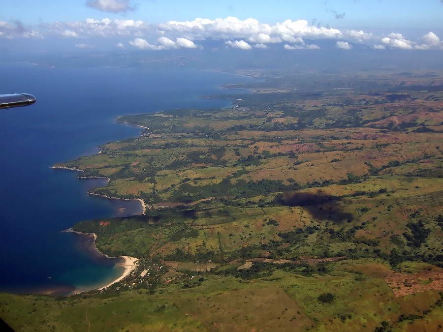
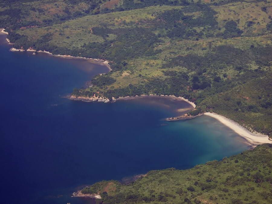
What an adventure Batteryboy! It was hard going through the undergrowth and that's without anyone shooting at you! Were the two soldiers with you armed? Were there supposed to be NPA in the area? Too bad Google doesn't have high-res satellite images of the Qinauan point area. However I'd like to borrow John Moffit's excellent aerial photos. I think Karl originally showed it to me when I asked him about his hikes on the west coast of Bataan. (Thanks for taking these excellent shots John!) In this photo I think Aglaloma Bay is the upper bay in the picture. I've had difficulty matching it with the maps.  Caibobo point to Bagac 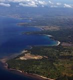 |
|
|
|
Post by fots2 on Aug 7, 2009 21:27:24 GMT 8
|
|
|
|
Post by fots2 on Aug 8, 2009 0:24:11 GMT 8
Help yourself batteryboy and Victor.
I have no idea what is where so I'll learn something too.
|
|
|
|
Post by okla on Aug 8, 2009 1:12:52 GMT 8
hey fots...when i first viewed the photo of the abandoned "nuke" facility i thought "now why would anybody build a replica of a scottish castle on the coast of bataan?  on closer look one can see its a nuclear power plant. even my old, jaundiced photo interpreter's eyes could finally make that out. i still think it would be a fabulous location for my "retirement home". who would think that this whole, beautiful coastal area was the site of such vicious fighting so long ago? |
|
|
|
Post by fots2 on Aug 8, 2009 9:56:46 GMT 8
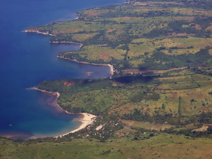
There are beautiful little beaches all along that coast with not a soul on them. That would be a retirement dream for many people. When you get that beach house okla, a boat ride would put you at South Dock on Corregidor any time you wanted.  |
|
|
|
Post by okla on Aug 8, 2009 10:09:36 GMT 8
hey fots...you really know how to hurt a guy dont you? if i could implant my wife in a retirement home in that environment with those beaches, she would let me prowl all over bataan and corregidor with no thought of divorce procedings. but alas, i am doomed to remain here in the badlands, depending on you, batts, phantom, vic and the others to keep me informed and up to date on new discoveries. |
|
|
|
Post by okla on Aug 9, 2009 22:42:35 GMT 8
hey batts....thanks a bunch for contributing your "sketches" and accompanying narratives. really good stuff. one question....do you happen to know what shape the west road is in nowadays??? i read in some book (perhaps john toland's "but not in shame") back in the 1970s that after a couple of miles north of mariveles that vehicles were out of the question. just wondering what condition this road is in 2009. for all i know there might be something akin to the pennsylvania turnpike. not really, just kidding, but in the intervening years the local bataan province officials might have seen fit to construct a passable thoroughfare going north. maybe nothing like what is available on the east shore of bataan, but a road that would serve a new batch of "sketchers". again, outstanding post.
|
|
|
|
Post by okla on Aug 10, 2009 0:18:54 GMT 8
hey batts....will be looking forward to the next edition of "sketches" as i do "fots foto" tours. what a great way to spend part of my so called "golden years", prowling bataan and corregidor in the comfort of my den chair. next best thing to actually being there. have a cool day. its 100 degrees here in the oklahoma badlands.
|
|
|
|
Post by victor on Aug 10, 2009 11:54:38 GMT 8
Fots, great pictures... you probably have the only modern day aerial pictures of the Points. What a boon to us history buffs. Batteryboy, I've dreamed of doing the same things you and your friends did 23 years ago. I'm so envious. The soldiers who escorted you probably patrolled the area a lot during those days. They seemed to know the paths well. Did you encounter any wild life? Wild boar? Deer? Snakes? Did you actually dig up those dud shells you found? Or were they just laying on top of the ground? Any pictures? Looking forward to hearing about more battlefield visits  |
|
|
|
Post by The Phantom on Aug 11, 2009 2:35:30 GMT 8
From "The Fall of the Philippines" background on the fighting in one area in question.
'ON THE MORNING OF JANUARY 18TH GENERAL KIMURA REACHED MORON AND ASSUMED CONTROL OF OPERATIONS.FOR THE ASSAULT AGAINST WAINWRIGHT'S LINE ALONG THE RIDGE SOUTHEAST OF THE TOWN. HE ORGANIZED 3 FORCES.THE 122D WAS ATTACK DOWN THE WEST ROAD; THE 3RD BATTALION, 20TH INFANTRY, WAS TO SWING EAST OF MORON IN THE ATTEMPT TO TAKE THE RIDGE POSITION ON THE FLANK.
THE THIRD FORCE WAS SENT HIGH UP INTO THE MOUNTAINS AROUND I CORPS FLANK TO CUT THE PILAR-BAGAC AND DID NOT PARTICIPATE IN THE ENSUING ACTION.
IN HIS BELIEF THAT HIS FORCE WAS NOT STRONG ENOUGH FOR A SUCCESSFUL STAND ALONG THE RIDGE, WAINWRIGHT ON THE 18TH DIRECTED THE WITHDRAWAL.
THE FIRST INFANTRY AND THE ENGINEERS FELL BACK THROUGH THE OUTPOST LINE TO TAKE POSITION ALONG THE MAIN LINE OF RESISTANCE BETWEEN THE 3RD INFANTRY AND 31ST FIELD ARTILLERY ON THE SLOPES OF MT. SILANGANAN.
THE JAPANESE FOLLOWED CLOSELY AND THAT NIGHT DROVE INTO THE CORPS OUTPOST LINE.A COUNTERATTACK THE NEXT MORNING RESTORED THE LINE BUT ANOTHER JAPANESE ASSAULT ON THE NIGHT OF THE 19TH GAVE THE JAPANESE FINAL AND PERMANENT POSSESSION OF THE OUTPOST LINE.
AS THE 122D INFANTRY CONTINUED TO PUSH AGAINST THE FIRST DIVISION TROOPS ON THE LEFT OF THE MAUBAN LINE, THE 3RD BATTALION 20TH INFANTRY, WHICH HAD BEEN SENT AROUND THE EAST FLANK OF THE RIDGE LINE ON THE 18TH SWUNG BACK SOUTHWEST INTO THE I CORPS AREA.
UNOPPOSED THE BATALLION EITHER INFILTRATED THROUGH THE I CORPS ALONG THE SLOPES OF MT. SILANGANAN OR ADVANCED THROUGH A GAP BETWEEN THE 31 ARTILLERY AND THE 1ST INFANTRY.
AT ABOUT 1000 OF THE 21ST IT REACHED THE WAST ROAD, 3 MILES EAST OF MAUBAN IN THE VICINITY OF KILOMETER POST (KP) 167, AND ESTABLISHED A ROADBLOCK BEHIND THE 1ST DIVISION
BY THIS MOVE THE JAPANESE HAD PLACED THEMSELVES SQUARLY ATHWART THE ONLY MAJOR ROAD SUITABLE FOR TRANSPORTING HEAVY EQUIPMENT AND SUPPLIES. THE DANGER TO WAINWRIGHT'S POSITION WAS A GRAVE ONE.
"THE INITIAL JAPANESE ROADBLOCK WAS ESTABLISHED BY ONLY A PORTION OF THE THIRD BATTALION, 20TH INFANTRY BUT DURING THE DAY THE REST OF THE BATTALION FILTERED INTO THE ROAD BLOCK.
AT THIS TIME THE REMNANTS OF THE 26TH CAVALRY WAS IN A DEFENSIVE POSITION ALONG THE PILAR-BAGAC ROAD."
(Over several days numerous attacks were made against the roadblock with no effect.)
"RODMAN'S INABILITY TO MAKE PROGRESS AGAINST THE ROADBLOCK WAS NOT FOR LACK OF TROOPS.
BY THE 24TH OF JANUARY HE HAD, 2ND BATTALION 92ND INFANTRY, 1ST BATTALION 91ST INFANTRY; 3RD BATTALION 72D INFANTRY; THE 2ND SQUADRON, 26TH CAVALRY; 2 BATTALIONS AND A HOWITZER COMPANY.
ALL OF THESE UNITS, IT MUST BE STATED WERE UNDERSTRENGTH, TIRED , POORLY FED, AND EXCEPT FOR THE 26 CAVALRY SQUADRON AND THE HOWITZER COMPANY HAD NO AUTOMATIC WEAPONS."
THE JAPANESE DEFENSE OF THE ROADBLOCK IN THE FACE OF SUCH STRONG OPPOSITION BASED ON THEIR SIZE AND LACK OF RESUPPLY WAS THEREFORE THE MORE REMARKABLE, EXPLAINABLE ONLY BY THE DIFFICULTY OF THE TERRAIN, WHICH FAVORED THE DEFENDER, BY TRAINING AND DETERMINATION."
The rest of the line began to collapse and retreat via the beach was necessary since the Japanese blocked the only passable road. All trucks, artillery and equipment that could not go by beach had to be destroyed.
|
|


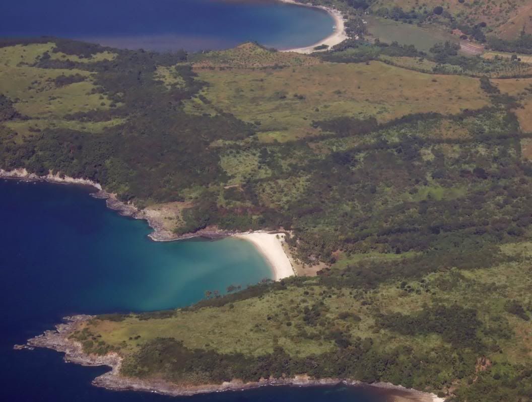


 on closer look one can see its a nuclear power plant. even my old, jaundiced photo interpreter's eyes could finally make that out. i still think it would be a fabulous location for my "retirement home". who would think that this whole, beautiful coastal area was the site of such vicious fighting so long ago?

