|
|
Post by fots2 on Aug 5, 2012 22:47:39 GMT 8
Hey Chad, when are you and your wife coming back to help with the search? We could have some fun.  |
|
|
|
Post by pdh54 on Aug 5, 2012 22:52:58 GMT 8
Fots,
I would LOVE to come back to the Philippines, older and wiser now, not a timid, shy Navy wife. (laughing)
Patty
|
|
|
|
Post by chadhill on Aug 11, 2012 9:20:39 GMT 8
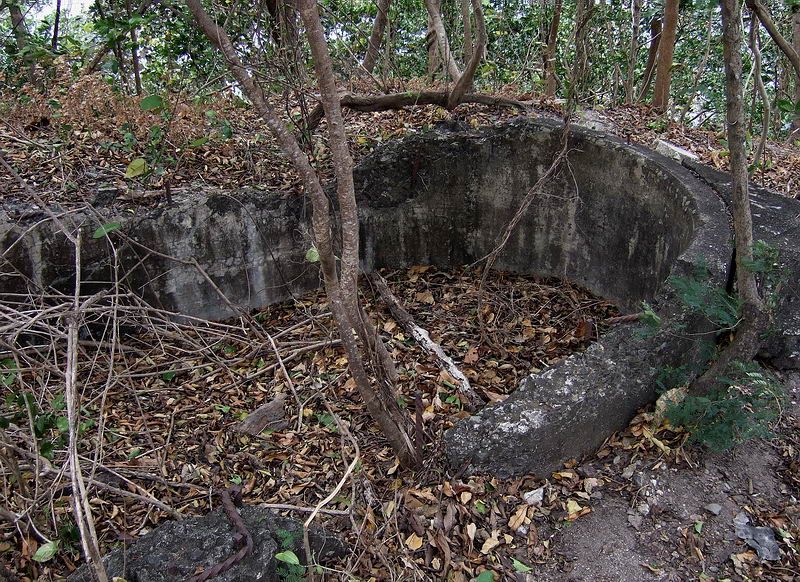
Here is a still photo from the 1942 Japanese newsreel fimed shortly after the surrender. It was taken from the "little hill" on the north side of Malinta Hill. The photographer was standing with the pom-pom gun on his immediate left. He was filming down hill from the position of the gun, and looking north.  Here is a 2009 photo (courtesy fots2) showing the ruins of the supplementary command post on the northern edge of Malinta Hill. It was shaped like a "bath tub" and known in military nomenclature as EG-IV-3.  Here is a portion of armyjunk's photo showing the location of EG-IV-3. Red notations courtesy fots2.  Now, here is the Japanese newsreel still photo again. Is the structure in the upper left corner possibly the supplementary command post EG-IV-3?  Armyjunk, if my memory serves correctly I believe that some time ago you posted a prewar interior view photo of EG-IV-3 (or maybe it was a different "bath tub"?) on another website which showed some optical instruments inside the "tub". If that is correct, would you mind sharing that with us here? It would be great for comparison and learning purposes. Thank you much in advance, Chad |
|
|
|
Post by wwalker on Aug 11, 2012 9:48:48 GMT 8
Hello Chad,
I have been following the posts about the "Pom Pom Gun" located on Malinta Hill, and thought I would pass along a source of some footage of this gun as it looked on the days after the surrender. There is a recently released documentary entitled "The Tragedy of Bataan" that can be purchased on the pbs.org website. On this disc, in the special features, there is about 30 minutes of footage from a Japanese new reel of the ruins of Corregidor in the day or so after the surrender. Some of the footage includes the POW's in the 92nd Garage Area. In this camera footage it shows the gun in question. I own the disc but have no way of copying or posting the clip.
The documentary is good, and deals mostly with the Bataan Death March. However, in the special features section there is some good interview footage of a few Corregidor survivors, and of course, the Japanese news reel footage. Perhaps this footage could help you out.
WW
|
|
|
|
Post by chadhill on Aug 11, 2012 11:46:33 GMT 8
Thanks WW, we got on line after getting the word from you and ordered it! Gracious.... Now it's clear where this corrogated sheet metal came from....photo from the top of Malinta Hill, 1987. Pieces were spread over parts of the northern ridge.  |
|
|
|
Post by fots2 on Aug 12, 2012 0:10:01 GMT 8
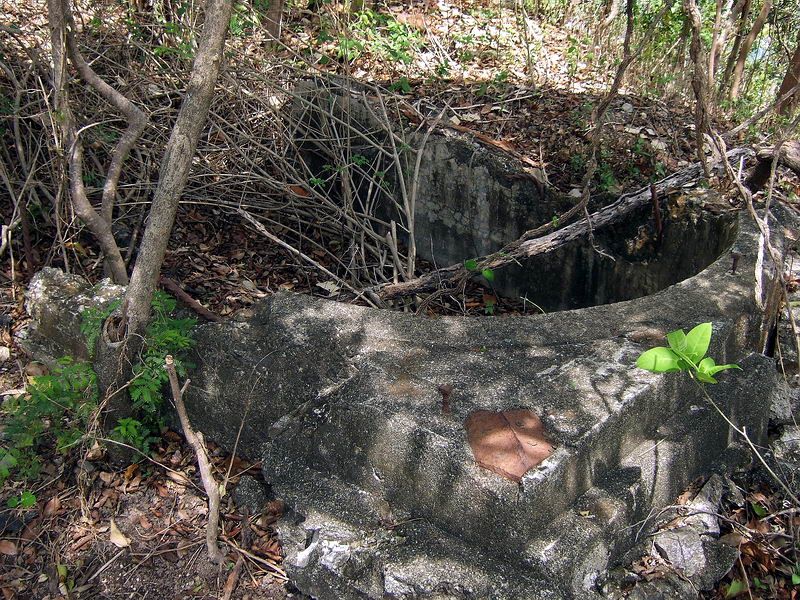
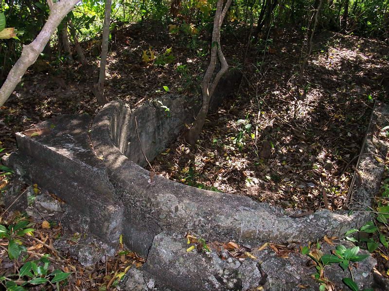
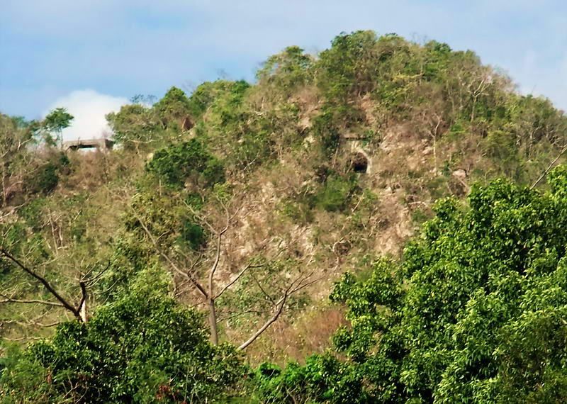
Hi Chad, I agree with your comments about the position of the 1.1 inch Pom Pom, the buildings, EG-IV-3 and SL #8. Regarding the Japanese newsreel still photo (which is looking north), the structure you point out as possibly being EG-IV-3 appears to be oriented east-west. I do not think it is EG-IV-3 due to (1) EG-IV-3 being oriented almost north-south along the same line as the ridge and (2) the bathtub shaped walls of EG-IV-3 are approximately three feet at their highest. The structure in the Japanese photo seems to be quite a bit higher than that. It may have had a wooden upper section but it is still orientated the wrong way. The N-S ridge is quite narrow at the northern end. If you stand in EG-IV-3 and walk east more than 6 paces you will end up 200 feet or so down the hill within a few seconds…it is that close to the east side cliff. From EG-IV-3 to the west side drop-off is even a bit closer. I would not call this a cliff but it is steep enough that you have to hold onto trees to get down safely. Here are a few additional photos of EG-IV-3.    This photo is looking in a south-eastern direction. You can see how close the eastern cliff is to the bathtub. The dark area in the extreme upper right corner is top of the SL #8 air shaft.  This zoomed in view was taken on Tailside looking west toward Malinta Hill. It does not look steep but it is. In the dry season you can make out the intact 75mm gun shelter and the entrance to Searchlight #8 tunnel. As you can see, it is not very far between the two points. About the corrugated metal, small sections of it are scattered all over and on both sides of the hill. Remember the newsreel photo of the 75mm gun shelter where you can see tall cylinders used as shrapnel protection? Even those cylinders can be seen in a few places. One final note, I am impressed with the quality of screen captures you get from that fuzzy old newsreel. Good job there. |
|
|
|
Post by okla on Aug 12, 2012 1:23:43 GMT 8
Hey Guys....Viewing those Japanese newsreel shots shows what a beating Corregidor took in the month preceding the actual landing. Even the guys secluded in tunnels and bomb proofs had to be "punchy", even though they were out of "harms way" from the Emperors air/artillery bombardment. Postscript....Fots/EXO--Are you guys high and dry after that deluge. The way I get it here in the parched Badlands of Oklahoma, most of the flooding is near Manila. Am I correct. Karl lives at Subic, if memory serves, so I assume he is, hopefully, above surface. Even being an ex-USN diver, I betcha he would have a gut full of dealing with unwelcome wet stuff.
|
|
|
|
Post by chadhill on Aug 12, 2012 2:36:17 GMT 8
Hello fots, thank you for your comments and for including the additional images of the "bath tub". Now, if armyjunk can come up with a photo, too... ;D  Yes, the walls of the structure in the Japanese newsreel photo appear to be too high. But your photos show bolts on the top of the tub that may well have secured an upper section. Back in Reply #71 you gave the tub's dimensions as being about 9' long (N-S) by 6' wide (E-W), and I saw from armyjunk's photo that the tub ran lengthwise N-S with the ridge. Maybe we simply see the structure's apparent orientation differently in the Japanese photo. Although it is largely concealed from view, it looks to me like it could just as easily be oriented N-S as opposed to the E-W that you see. Also, the side directly under the yellow arrow (N side) strikes me as having a shallow curve, while the W side seems straight on the top. But I admit this is certainly subjective and there is plenty of room for SWAGing here. In armyjunk's photo the stairs look to be NE of EG-IV-3 on the very narrow ridge. In the Japanese photo that would be to the right side of our unknown structure if it is indeed EG-IV-3, so it is positioned correctly in that regard. Thanks again for posting those great photos. Your points are well taken and I may just be seeing pink elephants again. The Malinta Hill pic reminded me of my climb to the top in '87...sometimes I did things the hard way in those days- |
|
|
|
Post by chadhill on Aug 12, 2012 12:09:41 GMT 8
Something oozlefinch said on another thread got me to thinking. After viewing the Japanese newsreel and seeing the corrugated roofs on the north side of the ridge, he mentioned the air shaft for Searchlight #8. First, here is an onsite photo showing the supplementary command post EG-IV-3 and how close it is to the air shaft: (photo courtesy fots2)  I studied the photo from the Japanese newsreel and came up with a couple of SWAGs (yes, two) for the possible location in the photo of the SL #8 air shaft. I may be sticking my looney-bin neck out real far with this, but here goes:  First, the red arrow on the right. It points to an uncovered (no roof) corrugated fence that seems to be round. What may be sandbags have been tossed on top of the far side of the fence. I do not recall how wide the air shaft was but think that it might fit inside this fence. The red arrow on the left points to an area that is less defined. There seems to be a depression here, but what drew my attention was what appears to be a displaced or collapsed corrugated roof on the left. Recall that on 4/29 a Japanese 240mm shell penetrated down the SL #8 air shaft and exploded in the tunnel below. That would certainly account for the roof. But frankly, I am surprised how relatively little damage this entire area seems to have had considering the bombardment that occurred on Malinta Hill. We are looking roughly north in this photo, and if the yellow arrow points to what really is the command post EG-IV-3, then it seems to me that both air shaft candidates are about on the proper bearing from EG-IV-3. Fots has said that the air shaft is about six paces from the command post but I don't have a good feel for distance in this photo. I told ya'll this was a SWAG. Could be a reeeeeal SWAG at that...  |
|
|
|
Post by fots2 on Aug 12, 2012 19:31:03 GMT 8
Hi okla,
I am high and dry in my part of the country. EXO has had problems but is fine. Karl got his feet wet getting home but is fine also.
Many people were not so fortunate and are now trying to get back to normal. News reports say 3 million people were and still are affected by the flooding. The death toll so far is 85. Another storm is on the way. Too bad we cannot send a few clouds in your direction.
Thanks for the concern buddy.
|
|