|
|
Post by Karl Welteke on Nov 20, 2009 19:48:05 GMT 8
Friends My Canadian Friend AJM and I met on Corregidor 14th Nov 2009 and we took 3 trips. We went to the points, the Tailend and ex Fort Frank. Here is the 1st of 3 installments with 50 images about going to Wheeler Point, Search Light Point and noticing a new land slide that affected Search Light # 2: app.photobucket.com/u/PI-Sailor/a/dc1a681e-789b-4f3b-9521-2f12ab937f2f?field=TITLE&desc=ascIf it does not open, copy and paste it into a browser! And as I normally do I kept a dairy, here is the entry for the first day: Corregidor Dairy 2009 Nov. 14th to 16th Day 1, Saturday, 14th Nov. 2009. Arrived on Corregidor about 8 am and dropped my gear in the MacArthur Café in a fan room for about 750 Peso a night. Had driven down to Villa Carmen in Cabcaben with my car and they had the boat ready. Met up with my Canadian friend John Moffitt, who already arrived a day earlier. He reported that he made the hole entering the 1918 barracks tunnel in the James Ravine bigger and got in and out without problem yesterday. He also discovered 3 graves with markers of Philippine Scouts from 1920s in the James Ravine – very interesting. The American couple, Steve and Marcia Kwiecinski who reside on Corregidor also met us and we all took the same boat to Wheeler Point. I showed them the way to Battery Monja and then proceeded to find #4 Search Light at the end of Wheeler Point. Based on the experience of a previous visit I decided to go on the NW side of the point and found it relative easy to walk there. On the SE side, at places it is too steep, on the top is very narrow and restricted because of vegetation. The best way to get to the search light is go the very end of the point (NW side) and then up. On the way there I found what I believe are defense positions VIII-M-3 and VIII-F.1. VIII-F-1 is fairly easy to find but is about 80% buried. VIII-M-3 is completely over grown with bamboo and I only got one image shot of concrete by lying on my stomach. The way we got up to Battery Monja is by entering the ravine (SE side) which has a little water running, about 30 feet in and then went straight up. At the very beginning a line was helpful getting up and down later. After one gets passed the about 15 feet steep stretch we headed diagonal up and west and reached the ‘Cut’. My other partners also went to see the search light #4 after they a good look at the Battery Monja Tunnel After that we went down and used the boat to get to search light #5 on Search Light Point. I didn’t go with the boat; one of my goals was to walk around ‘No Name Point’ and Search Light Point and did that. It was low tide but I still had to swim at one place on the east side of Search Light Point. We proceeded onto Search Light Point, on to S.L. #5 and found it without too much problem. I had been there before and had the impression the search light track-way sagged. We tried to find then Defense Position VII-M-4 but failed. We failed because of the grass or it is gone. After all this we were pooped and out of water, I used 3 liters. We want back to North Dock. The boat received 3000 Peso for the trip to the points and my trip to Corregidor Island from Bataan. At MacArthur Café we ate and made planes for tomorrow. The weather and North Channel were at optimal condition, sunny and light NE wind and there were no ocean swell which made the boat landings easy. On the way back to North Dock we noticed a large and new land slide at Rock Point. I’m sure it touched Search Light #2 and I believe a section of the search light track-way is hanging over the cliff now. In the evening I met two interesting men, both looked Caucasian but were Filipinos. Kent said that his boat was damaged and brought it to the 92nd Garage area to work on in the next 2 month. His partner was Charlie, husband of Patsy. This couple used to run an Inn where the Corregidor Hotel stands now. Many of the WWII veterans who returned to the Rock and were their guests always spoke and wrote glowingly about their hosts and all the other Islanders who made their stay very memorable. A veteran copied all the relevant entries of these WWII Veteran guests in Patsy’s guest Log and they got posted in the corregidor.org web pages: www.corregidor.org/503_fox/patsylog.htmEND |
|
|
|
Post by Karl Welteke on Nov 21, 2009 13:02:40 GMT 8
Friends This is the 2nd installment with trip description and 43 images. We went to Carabao Island, ex Fort Frank, but I was the only one to get on and take some images. Here they are: app.photobucket.com/u/PI-Sailor/a/56c65d28-05de-4de4-9721-b90b303ca9d6?field=TITLE&desc=ascIf this does not open, copy and paste it into a browser! Here is the dairy entry for this day: Corregidor Dairy 2009 Nov. 14th to 16th Day 2, Sunday, 15th Nov. 2009. Based on the experience yesterday (no sea swells, light NE wind and a low tide) we ordered a boat from Villa Carmen in Cabcaben to take us to Fort Frank, Carabao Island at 0830. We were planning to go under the wall at the desalination plant, west side of the island. They wanted and we paid 3500 Peso. After a little over an hour ride we arrived at Fort Frank. The wind was much stronger then yesterday and worse there were ocean swells, they came from the NW. Maybe yesterday, at the west end Corregidor, we didn’t have any swells because the land points at Mariveles were protecting us from NW swells. My 3 partners, John, Steve and Marcia, didn’t think it was safe and didn’t go. I went in with three walks to get one piece of gear at a time under the wall. I thought it was passable. I walked up the steps which were wet at places and immediately went higher over the connecting land bridge which connects Battery Crofton. One of my goals was to check the feasibility to climb up on the opposite gulch of the one with the wall where I came up. I got the impression it could be done and I let you judge by the images. Still I don’t know whether a boat can come close enough to offload people safely. And still the first climber would have to be agile coming up; much of the slope is fine gravel and need to be brushed away. If the first climber was to rig a line it should be easy to get up there. I would like to try it next time. The reason for all this is, that gulch or slip is the most calmest water around the island and one wouldn’t have to worry about the risky boarding of the island either on the west side under the wall or east side, onto the wharf because of wind, swells or tides. These are the only places one can enter Fort Frank and with Philippine Banca boats it is always difficult and risky. While I was on the island I noticed renewed digging at the desalination plant and the tunnel entrance to Battery Koehler. The trail between the Battery Koehler and Battery Greer sure needs maintenance, I constantly had to bend down under vegetation. Because of our situation I didn’t bother yet to put on boots and bolo. The trails from the upper end rail track (from the east side wharf) and it’s shortcut from there were ok. Where this trail meets the trail between the batteries I noticed another trail and followed it a little. It seems well used and it seems to run on top of the tunnel to Battery Greer. I communicated (texting) with my partners as to what to do and we didn’t come to a decision. So I saddled my gear and returned down to the wall. Down there it was obvious the swells had picked up and sometime they even looked like Waikiki breakers. Ok, we agreed to hang it up. Between the boat crew member and me swimming we got my gear and I back on the boat. I had a little trouble standing up going thru the surf because my sandals broke and slipped up my legs. We asked the boat crew to go around the island slowly so we could take pictures. The ride back took a little longer because of the NE wind generating local Manila Bay swells. They dropped us off at the Corregidor south shore at our request that saved time and water coming over the bow. We set down at the south beach watering hole and agreed to go our separate ways tomorrow. I was pooped and called it a day. We noticed the hotel rigged a sliding wire from the hotel to a solid frame near the beach but it was not yet in operation. The next day Steve and Marcia hosted a retired Lt Col of the US Army and who also is the son of a Philippine scout, who resides in the USA. His father served on Fort Frank during the war and was part of Battery ‘North’, the four 155mm guns. I told him I been at the battery once and we seen only 1 Panama mount. He then said with certainty that his father had told him there was only one, the others were in position the old field way. END |
|
|
|
Post by okla on Nov 22, 2009 2:39:01 GMT 8
Hey Karl....Really good stuff. Every time I view a map of Fort Frank I am always struck by it's proximity to the Cavite province shore. It must have been awfully creepy for those defenders to know that the enemy could be lurking in that undergrowth just a few hundred yards to the east. I am sure that they slept with one eye open (if they slept at all). I have always felt that Frank was the "forgotten" Fort of the harbor defenses with Corregidor, Hughes, and the "Concrete Battleship" getting the headlines. Do you know what the shortest distance was from Fort Frank to Cavite Province might be?  ? It has to be only a few football fields in length. |
|
|
|
Post by fots2 on Nov 22, 2009 8:35:08 GMT 8
Good guess, a few football fields is correct okla.
My topo maps shows the distance between Carabao Island and Cavite to be ~750 meters.
750m = 820 yards
820 yards / 120 yards = 6.8 football fields.
|
|
|
|
Post by Karl Welteke on Nov 22, 2009 16:15:59 GMT 8
Friends Here is the 3rd and last installment of our visit, to the Tailend of the Island and particular look at the cemeteries. There are 36 images in this album: https:// app.photobucket.com/u/PI-Sailor/a/dac4b3f8-dcfb-42ff-83f9-025f7b79ce1c?field=TITLE&desc=ascIf it does not open, copy and paste it into a browser! As before here is the dairy entry for this portion, the 3rd day for me: Corregidor Dairy 2009 Nov. 14th to 16th Day 3, Monday, 16th Nov. 2009. The Kwiecinski Family had other commitments, so John and I went to the Tailend. The hotel van dropped us off at the entrance to Kindley Air Field and we marched off. The Defense positions there and the new designated Moro Memorial have been completely grown over. We proceeded to the end of the runway, dropped down on the North-Road and found the West Cemetery without a problem. The entrance to it had a gate once and steps lead up and into it right from the North-Road so it was easy to find. We found only 5 to 6 tomb stones the rest are gone or are buried under decades of dropped leaves and branches. The cemetery is large, has a crumbled rock wall around it; but it is completely grown over with trees and bushes. It is said that many grave stones have been taken by fishermen as weights. When we were near the wall, we found what we believe was the east cemetery. We found a tomb stone and another crumbled one. This cemetery is small and has no walls around it. We continued to the Tailend, staying on top of the Corregidor Island Tailend ridge. At places we used a barely detectable trail or had to beat our way thru man high grass. Just before the dip in the ridge line we found that about 22 inches square hole in the grounds. I had seen it twice before and this time I took the time to look into it. It seems to be a 5 feet by 5 feet by 5 feet concrete cube. We did see a large monitor lizard in there. We dropped down to the beach and circled the East Point clock vice. The water was too deep to go to Hooker Point less you wanted to get your shoes wet and we didn’t want to. At the dip we hopped back to the east/north side and walked all the way into the bay, passed North- and Cavalry Point. Here we entered the bush and went inland and up to find the North-Road. On the North-Road we proceeded to the Philippine Heroes Memorial and the Japanese Peace Garden to get something to drink. I had used more than 3 liters already. Bad luck, because of the low visitor count today the souvenir shops were closed already but my buddy shared and he was almost out also. It was time to head for the nearest watering hole, MacArthur Café. On the way there John showed me a couple of things he had discovered lately. At MacArthur Café we met an American, a retired US Army Officer and a son of retired Philippine Scout who served on Fort Frank, manning the 155 mm gun battery. I told him we only seen one Panama Mount and he said determent “There is only one, the other 3 were in positions without them”. I had planned to go up there yesterday and look for more. But as you know our schedule yesterday didn’t go according to plans. I’m suffering from some kind of bug and felt bad for the last 8 days (throat, sinuses pain and nose running), so I called it a day. I feel pooped. Next morning I decided to go home and see a doctor about my sinus problem. I’m posting this on the 22nd Nov 2009, been on antibiotic medication for 4 days, the pain stopped and the symptoms have receded but I haven’t whipped the bug yet. END PS: Okla- Thanks for your comment. Fots, I think answered your distance question. |
|
|
|
Post by fots2 on Nov 22, 2009 23:23:52 GMT 8
Day 2: The wall at Fort Frank. You used up a few of your nine lives that day buddy. Here are some photos for your collection. --------------------------------------------------- These picture were replaced on the 10th Feb. 2024 because the old ones got watermarked by Photobucket 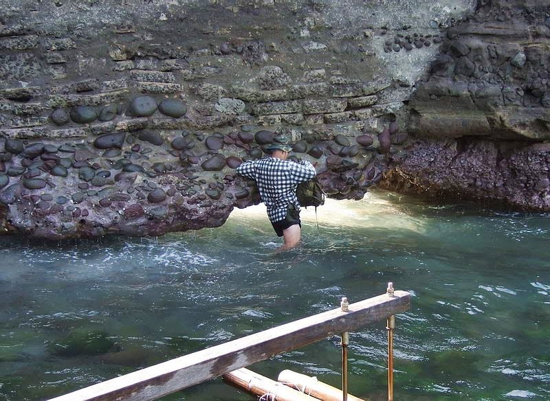 Zg673. Nov. the 15th 2009.This is how one enters Carabao Island, the ex Fort Frank, under the wall! This is a John Moffitt image. 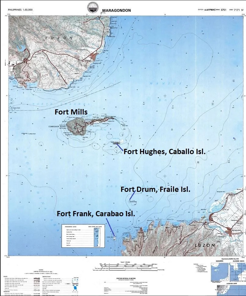 Zg674. Where is Ft. Frank? Here is a map! If you like to know the history, click here: corregidor.org/chs_bogart/bogart2.htm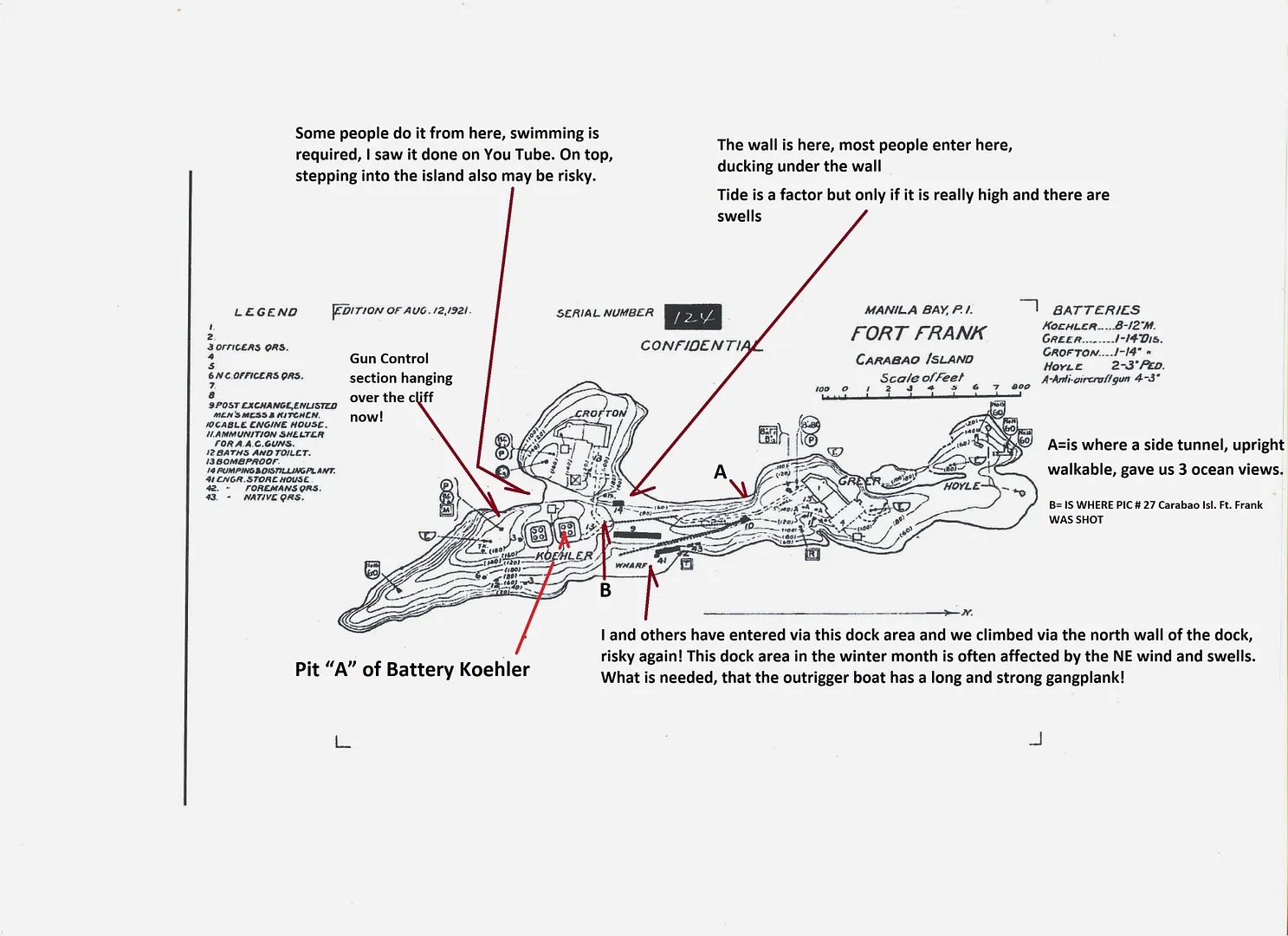 Zg675. Carabao Isl. Ft. Frank. Once, a long time ago, a confidential map of Fort Frank on Carabao Island and now marked with some factors about visiting the island. 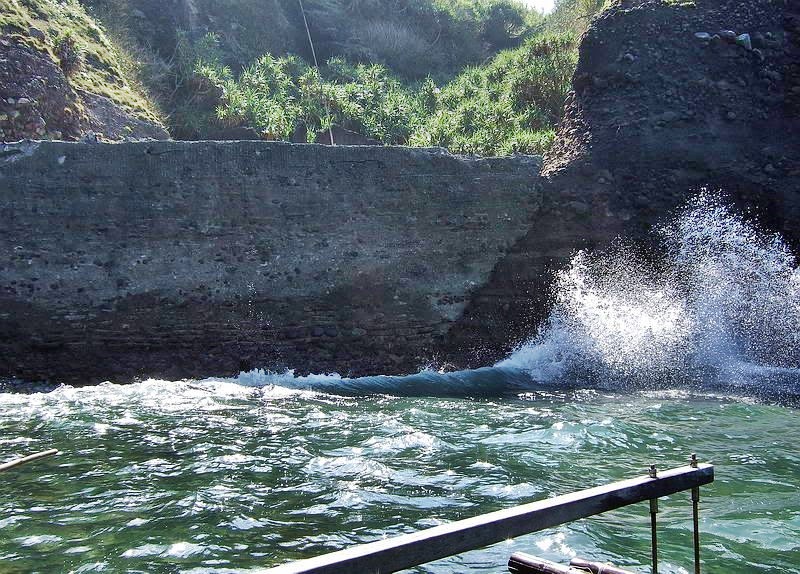 Zg676. The wall on Carabao Island, the hole under it is at right, the swell is hiding it. This is a John Moffitt image. 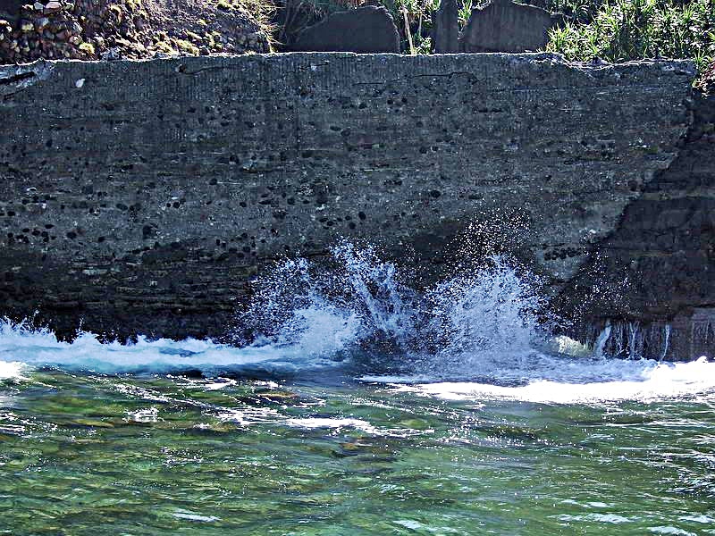 Zg677. The wall on Carabao Island, the hole under it is at right. In this picture we can see it. This is a John Moffitt image. 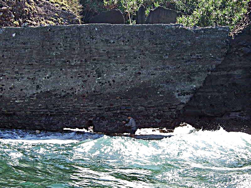 Zg678. Karl is coming and going several times under the wall, to get all my gear under the wall in a relative dry condition, camera etc. This is a John Moffitt image. 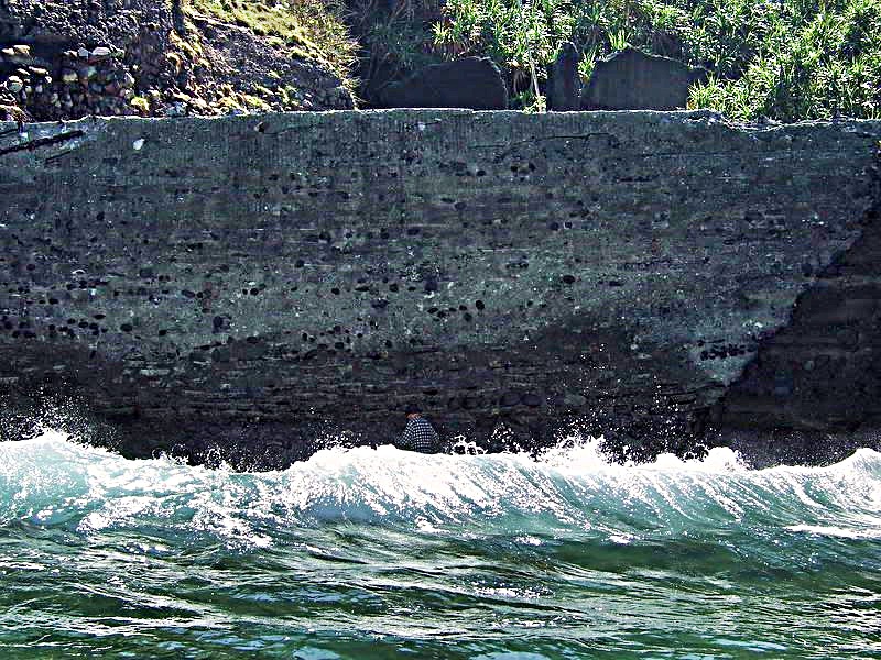 Zg679. Karl is coming and going several times under the wall, to get all my gear under the wall in a relative dry condition, camera etc. This is a John Moffitt image. 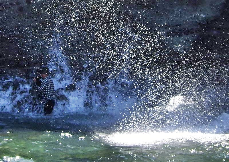 Zg680. Karl is coming and going several times under the wall, to get all my gear under the wall in a relative dry condition, camera etc. This is a John Moffitt image. 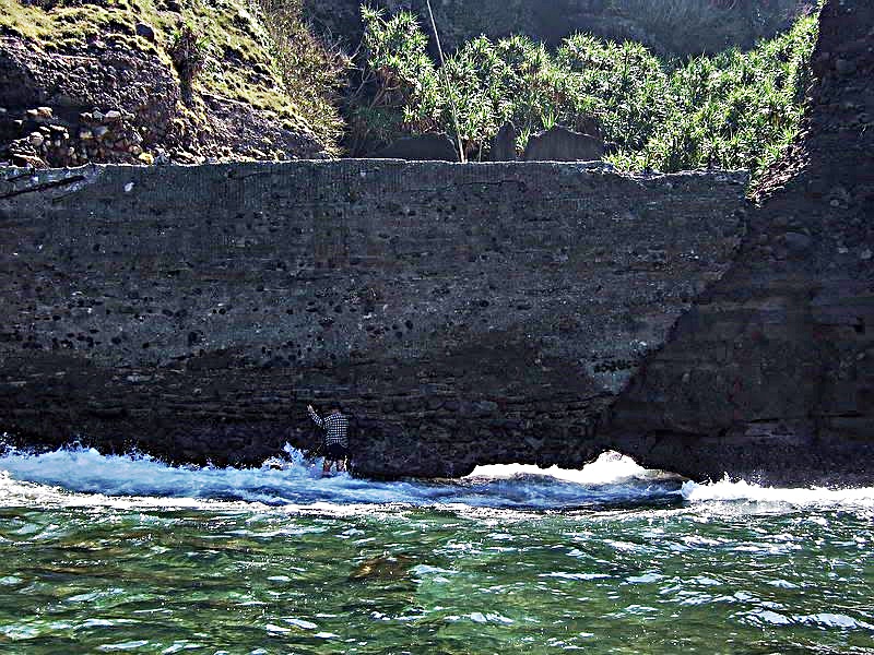 Zg681. Karl is coming and going several times under the wall, to get all my gear under the wall in a relative dry condition, camera etc. This is a John Moffitt image. 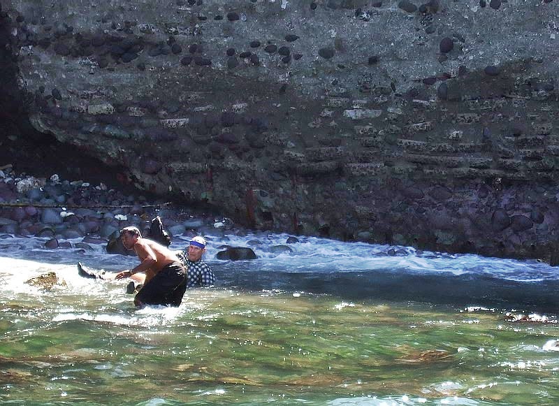 Zg682. It is not easy to walk here, because of the slippery big rocks and I made the mistake to walk with slippers. They broke and slid up my legs and I lost footage. A boat crew member came to me to get my gear. I WAS NOT WORRIED, I KNOW HOW TO SWIM GOOD, I was a Navy Diver. This is a John Moffitt image. 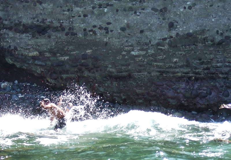 Zg683. It is not easy to walk here, because of the slippery big rocks and I made the mistake to walk with slippers. They broke and slid up my legs and I lost footage. A boat crew member came to me to get my gear. This is a John Moffitt image. 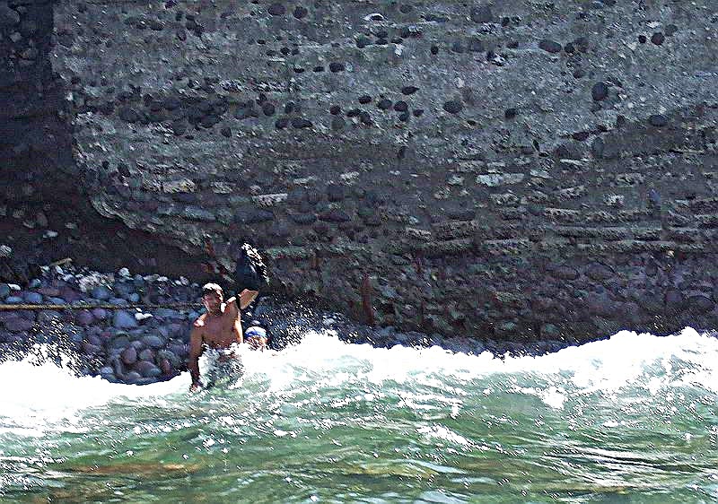 Zg684. It is not easy to walk here, because of the slippery big rocks and I made the mistake to walk with slippers. They broke and slid up my legs and I lost footage. A boat crew member came to me to get my gear. This is a John Moffitt image. 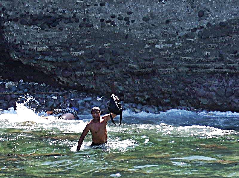 Zg685. It is not easy to walk here, because of the slippery big rocks and I made the mistake to walk with slippers. They broke and slid up my legs and I lost footage. A boat crew member came to me to get my gear. This is a John Moffitt image. 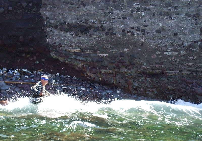 Zg686. It is not easy to walk here, because of the slippery big rocks and I made the mistake to walk with slippers. They broke and slid up my legs and I lost footage. A boat crew member came to me to get my gear. This is a John Moffitt image. 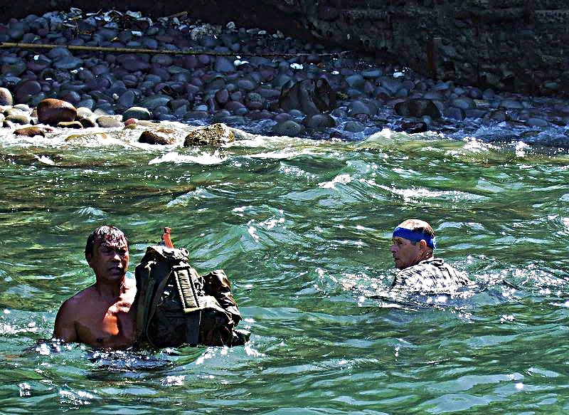 Zg687. It is not easy to walk here, because of the slippery big rocks and I made the mistake to walk with slippers. They broke and slid up my legs and I lost footage. A boat crew member came to me to get my gear. This is a John Moffitt image. |
|
|
|
Post by okla on Nov 23, 2009 0:53:23 GMT 8
Hey Guys...Many thanks for a most interesting tour of Fort Frank and the tail of Corregidor. Those two cemetery areas out on the extreme tail of the "rock" are kinda spooky. Sad, not knowing who those people are and just how many unmarked graves there might be. If the people that are vandalizing those burial sites are ever caught, they oughta be tossed into Bilibid (if it is still in use). Fots, thanks much for converting metrics to yards for this old goat. It always blew my mind when dealing with the metric system. Same thing with knots per hour instead of MPH. To this day I still use the length of an American football field to judge distance. This all stems back to when I played high school football and our coach (at the end of each practice) would line us up on one goal line and he stood at the other goal, holding a football over his head. He would drop it and we would run the hundred yards. This would go on till he was satisfied that we were worn out. I can still see him, standing one hundred yards away, holding that ball over his head. Hence, my fixation with 100 yard distances. I come pretty close to being correct when I try to judge how far some object is. One last thing.....seeing Karl wallowing in the surf at the Fort Frank wall only reinforces my feeling of what lengths a Corregidor/Bay Forts/Bataan "geek" will go to in order to feed his "addiction". What say you??? I must confess I would probably do the same thing. You hanging over the edge of cliffs could use up a few of your nine lives as well. Thanks again for your combined efforts in the latest "tour".
|
|
|
|
Post by fots2 on Nov 23, 2009 8:49:07 GMT 8
There certainly is some truth in those words okla. The addiction is strong.
I have cut back on my “nose first into tunnels” trips the past couple years. There are risks to such things that really are not worth it.
As for the cliff photos. The new cliff is curved and with a bit of camera zoom, it looked like I was right on the cliff. It was actually not too bad where I was. I must admit though, when I viewed the photos on the laptop, it scared me too.
|
|
|
|
Post by Karl Welteke on Nov 23, 2009 18:38:10 GMT 8
Thanks Fots for the great pictures. I didn’t think I was in any danger; (afterall I was a diver) my worry was to keep the cameras dry. Then later I had a hard time with my sandals, they were broke and I also couldn’t get them off. When I finally got them off I was ok, although to walk on those rocks, bare feet for an Americano, is not easy. Remember I went under that wall, back and forth about 6 times without too much problem.
|
|
|
|
Post by okla on Nov 24, 2009 2:19:25 GMT 8
Hey Karl....I figured you must have been a navy diver at one time since your avatar would suggest it. Also, you said, I believe, that you reside near Subic. If so, I have a question.....I read somewhere that at the very beginning of hostilities that several PBYs were destroyed by the Japanese while there were moored on the water at Olongapo or nearby. I was wondering during your service or even since while living in the area if you knew if the wreckage (engines, machine guns,etc) were still lying in the muck of the bay. Also would appreciate any info on the wreckage of the "hellship" Oryoku Maru that was clobbered by American planes and was either sunk or beached near the US Navy station at Olangapo, Subic Bay. I suppose there is no trace of it now. Just wondering. Little items, such as this, are always bugging me, so I just thought I would inquire of an old navy diver who holds forth at the very place where this stuff took place.
|
|


 ? It has to be only a few football fields in length.