|
|
Post by marycronkfarrell on Feb 23, 2012 9:49:11 GMT 8
Hi, This is a terrific collection of photos. I've never seen anything like it. I am writing a book for teenagers about the nurses of Bataan and Corregidor and I'm wondering if I might use a couple of the photos here? I would of course credit whoever owns them, and would also be happy to list this board as a resource. I would also be willing to share photos I've collected as well, if anyone is interested. Thanks so much! www.MaryCronkFarrell.com |
|
|
|
Post by fots2 on Feb 23, 2012 17:03:21 GMT 8
Hi Mary,
The old photos in the above posts are not mine and have been collected from various sites on the web. If I knew who to credit them to then I tried to do that.
The recent photos are mine and you are welcome to use them if you wish. No credit necessary. If you have any specific requirements w.r.t. Corregidor then I may be able to help.
(Note: This permission does not apply to everyone reading this message. Ask first please.)
I would be interested in seeing any old photos you have especially if they are Bataan or Corregidor related. Send me an e-mail at fots2 AT hotmail.com if you are interested and we can chat about it.
John
|
|
|
|
Post by fots2 on Mar 16, 2012 0:19:15 GMT 8
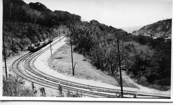
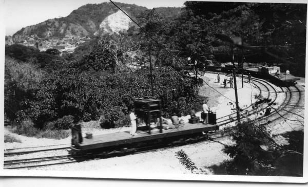
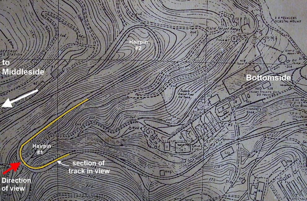
Then but no NowTwo old photos show the dual trolley lines as they snake up the hill between Bottomside and Middleside. The grade was steep enough that it was necessary to construct two hairpins along the route. Here are the two photos.  Photo #1.  Photo #2. This 1936 map shows the trolley lines coming up the hill from Bottomside. A few points are labeled.  I thought you might be interested in seeing the whole picture. There is enough overlap between the two photos so they make good candidates for stitching software. Here is a panorama of the two photos combined showing hairpin #1. Part of the bottom left side rails are cut off but that was done in the original photo.  The trolley line does not really look that steep but have a look at the ocean in the top centre of the photo. The original photos were taken tilted with respect to the horizon. Imagine tilting the panorama toward the right to level out the horizon and get a feel for how steep the trolley line actually was. Due to trees all up the hillside, there is no way I can get a current photo of the view we see here. The rails are gone but the rail beds, embankments and cut-off power poles still exist.
|
|
|
|
Post by okla on Mar 16, 2012 2:09:55 GMT 8
Hey Fots....These are great pics. If one didn't know better, and couldn't see a bit of Manila Bay in the upper center of the photo, you might think this was a view of a West Virginia coal mining operation,etc. (if the trolleys were coal hoppers). Don't you think this shot was taken during the early 1930s. I say this because Malinta Hill is "slick and clean" where the west portal of the famous tunnel would be. Surely this is soon after construction was begun, during, or soon after in 1932, etc. Not important, but you are fully aware of my rampant imagination when it kicks in full roar. Cheers.
|
|
|
|
Post by fots2 on Mar 16, 2012 19:52:34 GMT 8
okla, I do not know the date of these photos but you have good points.
Note the crew working at bottom left. Why are rails with the proper bend lying between the two sets of tracks? The electric trolley line would not be very old so I wonder why rails are being replaced.
|
|
|
|
Post by okla on Mar 16, 2012 20:57:19 GMT 8
Hey Fots...You have given us another little detail to ponder. The Belote Brothers state in their book that the Trolley system began service, running from Bottomside to the Topside Batteries, sometime around 1907,(after the completion of Malinta it was extended to Tailside, as I am sure you know) so maybe we have photographic evidence here of the ongoing replacement of the original rails. I have absolutely no knowledge of just how long steel trolley rails last before new ones are needed, but if this pic was taken in the early 1930s it would seem logical that major replacement and maintenance would be due. Those "hairpin" curves would, methinks, take more wear and tear than would the "straight-aways", thus might require more frequent replacement. I will now call on our "technical guru, Battery Boy", to shoot holes thru my drivel and give us the straight "skinny".  Cheers. |
|
|
|
Post by fots2 on Mar 16, 2012 22:50:33 GMT 8
Hi okla,
Good comments, thanks.
Corregidor became part of a military reservation in 1902. The Belotes may not have been specific but by 1907, only the cable train existed from Bottomside to Middleside. This route was different than the later constructed electric trolley line which is shown in the photos.
Rails to Doomsday states that “Congress approved the construction of a new electric line during 1907, several years before the heavy construction was completed. Construction commenced in 1909â€. A 1911 map does show the electric line as existing at that time.
We do not know the date of the two photos but you may be correct in why we are seeing maintenance being done on the trolley lines.
|
|
|
|
Post by The Phantom on Mar 17, 2012 4:20:09 GMT 8
Note the original cable Line Route on the above map---- shown coming out of Engineers Ravine, (across building Q on the 1936 map), then going under the bridge for the duel trolley tracks shown in the pictures. ( still in existence but both sides show a great deal of war damage, one side even laying against the other.)
The original cable lines ran next to building #533, Ammunition Magazine.
Having just been to the Ammunition Magazine, huge and blown to hell from the Bataan direction, it all clicks.
The old Cable route is pretty much gone, Except some small concrete towers on either side of the dug out trench where the cable line ran.
This visible section is between the Ammunition Magazine and just below the Salt Water Tank.
From the Ammo Magazine the route passes Building # 220 a recreation room--- then # 21 an oil house--- then #47 a salt water pumping station--- then #22 SALT WATER TANK.
( Which is today's fresh water tank)
The route follows the sidewalk short cut that goes in from the main road of today, the sidewalk entrance starts just past the Water Tower and ends just below the sports fields in front of the YMCA.
The map ends the Cable route just below the end of Middle-side Barracks, a bit below the YMCA and the portable Search Light shelters #530 and #531.
And across the present day road from the huge water storage ground tanks on Middle-side.
At the end of the Cable line the end is noted by a small unnamed structure but there is an arrow pointing to the structure from a box with a 2 inside? and No. 5 outside.
The buildings described above may be post cable line construction. A few are only on the cable line which leads me to wonder how long it operated in some restricted areas?
Did the cable line run to Topside at one time?
|
|
|
|
Post by okla on Mar 17, 2012 6:22:20 GMT 8
Hey Phantom....Does the sidewalk short cut include those steep cement steps. I have read somewhere, maybe on this forum, that those steps are located on the old cable route that was used in hauling construction materials to Topside. After there was no need for that operation, the steps were supposedly built for foot traffic. If memory serves, I asked this question a while back, or at least considered asking it. At damned near 80 years of age, I find this to be a frequent happening these days. Cheers.
|
|
|
|
Post by fots2 on Mar 17, 2012 18:16:45 GMT 8
Thanks to a generous person who gave me the book ‘Rails to Doomsday’, I can tell you that the cable line tracks did go up to Topside where steam locomotives then took over the job.
Phantom, our little hike two weeks ago from the Stockade level down to Engineer Ravine following the cable line was an interesting trip.
Okla, as far as I know the upper steps (known as the 300 steps) was the upper section of the cable line from Middleside to Topside. The lower concrete walkway from Middleside to the Stockade level does not follow the cable line but is parallel to it.
|
|