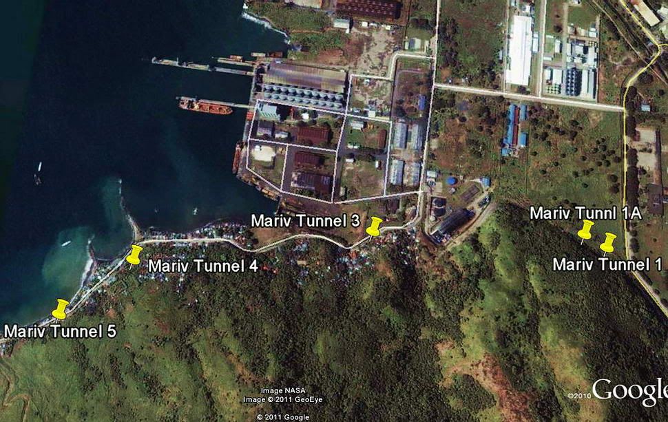
Mariveles Navy Tunnel #1 UpdateOne week ago, Navy Tunnel #1 was reopened again. The entrance had collapsed recently due to heavy rains which is common at this time of the year. Fireball had made the arrangements and the work was completed a few days later. There has not been much good weather recently but we decided to make a trip back there for another look around anyway.
Outside the entrance and the above cliff face actually looked quite normal. The collapse had occurred down inside the entrance where there is loose rock and now lots of mud. It was a bit narrow getting down into the tunnel and through the soupy mud but not difficult at all. It did not look dangerous at the time or I would have aborted the trip.
There is no breeze inside the tunnel and no air shafts are visible anywhere. It is hot and humid. The air is fine but seems a bit thin. The bats don't seem to mind though.
My last visit to this tunnel was in January which is in the dry season. The only differences I notice now are a couple shallow pools of water along the main shaft and the crystal clear waters of the deeper pools are now a bit cloudy. Generally the tunnel floor is dry and dusty.
I recently bought a much more powerful LED light (800 Lumens) that I was anxious to try out in the tunnels. I can now see a fly on a camel's ass while it is still in Africa (or something to that effect).
At the end of the main shaft across the deep hole, we had been wondering if the tunnel actually continued further past what appears to be a collapse. Fireball had brought a small boat and was over there at the collapse a few days earlier. From what he saw then and what I could see now, we both feel that the tunnel may not go further past the fallen rock. Of course, we cannot be 100% sure of this.
It was interesting to learn that fireball had discovered the depth of the water filled rectangular shaft at this location. Why someone would dig such a shaft (9 metres/30 feet deep) is still a mystery. Is the broken rock at the end of the tunnel just some of the rubble from when this shaft dug? We don't know.
The other water filled shaft (2 metres/6 feet deep) is at the end of the first left side lateral as you enter the tunnel. Now you will see a plastic water pipe lying on the tunnel floor from here heading back outside. Norlito, the owner of the land outside the tunnel, is now getting his drinking water from here.
A look at the stacked rocks and solid end to the tunnel above them gives us the impression that this lateral does not go further either. I had planned to clear some of the rocks away to find out for sure but cannot get near them now as I would definitely screw up Norlito's water supply.
As you enter the main tunnel, the second lateral on the right has always been of interest to those who visit here. A narrow slit at the end has bats flying in and out so we knew for sure that the tunnel goes further.
It is an awkward feeling to be kicking your legs to help slide through a rock opening where both your shoulders and butt are just scraping the top. Also, keeping your face down so as to not end up nose to nose with a speeding bat is a good idea. This is the tightest of any location I have passed through and hopefully never again.
The first mini chamber is low but you can sit up. A similarly low area is further ahead. Fireball went first and emerged into another chamber. Through the rock slit, I could see him surrounded by numerous unhappy bats. He had a look around and said that he could see a complete collapse at the end of the chamber and could go no further. I saw no point of following him in there and we decided that there was nothing else we could do here today.
When you view Karl's tunnel map of Tunnel #1, I would estimate this lateral be almost twice as long as he shows it to be. This lateral still could have extended to a parallel tunnel but we cannot prove it.
There was no new earth shattering discoveries but it was still an interesting day. After this we went over to Mariveles proper to have a look at possible locations of the two Air Corps tunnels adjacent to the old airfield. I had plotted the four corners of the airfield into my GPS as a guide.
The air strip is totally covered by buildings today. I did not even see any remnants of it such as the metal interlocking plates they used to put on unsurfaced ground. In some places these plates are still used by people as fencing etc.
To the east of the air strip is a significant hill which certainly seems like a potential location of the tunnels. To examine the hillside would require walking along and through densely packed private property and houses. This can be done but doing it in good weather during the dry season might be a good idea. Vegetation is thick in the area now too.
Perhaps another trip to Mariveles someday would prove interesting.
* My camera was out of service for awhile so no photos were taken this day.
