|
|
Post by fots2 on Nov 15, 2011 9:31:56 GMT 8
Hi okla, I did some searches on the internet. It appears that the answer to our 1946 question is a bit of both scenarios. Some ships were sunk by storms and others were scuttled. I assume the scuttled ships were declared surplus at the end of the war and it was decided to dispose of them that way. 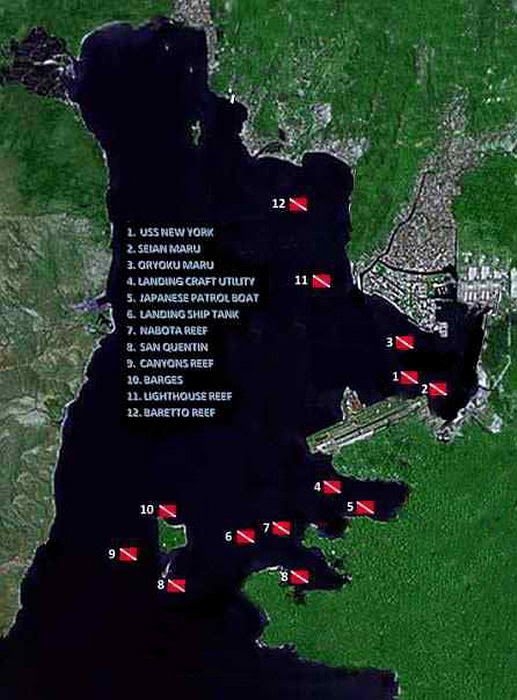 Here is a Subic Bay Dive Map of what wrecks recreational divers can visit. The map is from this web site: www.scubatechphilippines.com/scuba_diving_subic_bay.html It has lots of other good information also. |
|
|
|
Post by okla on Nov 15, 2011 10:27:54 GMT 8
Hey Fots....As I have said before, "you continue to amaze me". This is flat out, good stuff. The story of the "Rochester" will not be eating on my over active imagination. I had no idea that this vessel was the original USS New York. If memory serves(and it probably doesn't), the second USS New York missed being one of the Pearl Harbor targets when she, along with the Mississippi and Idaho were transferred back to the Atlantic Fleet. She also took part in shore bombardment on D-Day at Normandy. This is of secondary importance though, since our primary focus is, of course, the PHILLIPINES, and collateral matters. Thanks again for taking time to dig this info up. Cheers.
|
|
|
|
Post by fireball on Nov 15, 2011 12:40:00 GMT 8
Rumours of Submarines: Saw this in a trip finder review: (the staff) "Toured us for free around sites of interest, including old gun emplacements and submarine, yes thats right, submarine facilities entrance, al-be-it blocked because of danger and no, i do not think that that was a P'noy hyper-bole!" The mine casement: 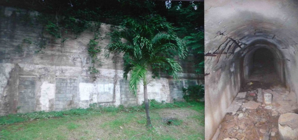 and from the resort website, along with baby sea turtles in their natural environment of the bamboo tray and 'creature' (2 birds facing each other), they do mention the military past:  But don't be put off this is a great place for a daytrip and I found all the staff when I visited very helpful and easy going (essential when wandering around ruins) |
|
|
|
Post by chadhill on Nov 15, 2011 15:25:58 GMT 8
The USS Rochester (CA-2) was scuttled on Christmas Day 1941 by a demolition crew led by Captain (later Major) Francis H. Williams of the 4th Marines.  Here is a photo taken in October 1941 of the Rochester moored on the north side of Rivera Point in Subic Bay. The arrow in the water is a fish trap. Photo courtesy corregidor.org.  The seaplane ramp used by the PBYs of PATWING 10 was on the south side of Rivera Point. On December 12, 1941 seven of the PBYs were floating near the ramp. They were surprised, strafed and sunk by Zeros. While I was stationed at Subic in the mid-late 1980s, it was rumored that the wreckage of the aircraft were still there. Unfortunately, diving in the area was prohibited. We were told that a diver had gone solo inside the Rochester, became lost, ran out of air and drowned. Thank you for the interesting histories of the Rochester and the Lanakai, fots. The image you posted of Subic Bay, with the location of the wrecks, caught my eye:  Notice the location of wreck # 8, identified as the "San Quentin". It is just south of Grande Isle. The San Quentin was a Spanish gunboat scuttled in 1898 during the Spanish-American War. Interestingly, it is not shown on nautical charts of Subic Bay I have from the 1980s, though many of the other wrecks from my previously posted list (reply # 33) and from fots' image are. In fact, there are no wrecks south of Grande Isle depicted. Now, here is a map from page 57 of the original 1944 hardcover edition of "The Dyess Story". Ed Dyess was CO of the 21st Pursuit Squadron, flying P-40s out of Bataan.  On March 2, 1942 Dyess led a much celebrated attack on Japanese shipping in Subic Bay. He is long believed to have sunk a tranport ship he estimated at 8000 tons, which exploded just south of Grande Isle, as shown on his map. According to Bill Bartsch in his book "Doomed at the Start", a navy observer on Signal Hill confirmed that a 10,000 ton vessel had blown up, two other large vessels had been set on fire, and two 100 ton motor cruises were sunk. Japanese records, however, admitted only to one 385 ton converted subchaser being either "sunk or damaged" (page 462, note 3). Is anyone aware of any known Japanese shipwrecks just south of Grande? Another one of the mysteries of war? |
|
|
|
Post by fots2 on Nov 15, 2011 18:22:10 GMT 8
Hi fireball,
The only thing that is submarine that I am aware of is the AC power cable coming from the mainland. Let me know if you stumble over any conning towers. ;D
Also the resort has done a little creative accounting. There are only two guns left on the island, #2 and #3 on their web site show the same gun.
Battery Flake’s “Tower†are actually magazines and storage rooms.
I agree, I found the staff to be a very nice bunch of people. Two guys I spoke to who offered to be guides know how to find many things but are unaware of their original names or purposes. I chose to explore alone as usual. It was a nice day trip to Grande Island.
|
|
|
|
Post by fots2 on Nov 15, 2011 18:23:48 GMT 8
Hi chadhill,
On the dive site map that we posted, I just noticed that there are two #8s. One south of Grande Island and one further to the right just off the mainland. The San Quentin was said to have been scuttled in 1898 at the mouth of Subic Bay. Of the two #8 locations, the one south of Grande Island matches this description the best. Subic Bay dive operator web sites say they dive on the San Quentin south of Grande Island in 6 to 18 meters of water so I guess that settles the issue.
I did not find any reference to Japanese ships being sunk south of Grande Island.
|
|
|
|
Post by okla on Nov 15, 2011 23:50:27 GMT 8
Hey Chad...Thanks for posting the photo of the Rochester/New York,etc. She was a fine looking vessel for her day, wasn't she?  . My mom's older brother served in the USN during the days of the "Great White Fleet", ending his service, as I understand it on the "China Station". It is probable that his earlier service was on such a ship as the New York/Rochester. I have a photo of him, in uniform, standing on the deck of one of his ships and from the "gear" behind him, it is obvious that his vessel wasn't some "rust bucket/tub". A ship of the line, she was, it would appear. Cheers. Again, I say, "welcome back". |
|
|
|
Post by chadhill on Nov 16, 2011 0:22:16 GMT 8
Hello fots2,
Agreed--the second, erroneously ID'ed shipwreck "# 8" that is east of Grande, in Ilanin Bay, is probably the El Capitan. It is wreck # 15 on the 1980s list I posted in reply 33. The correctly ID'ed # 8, the San Quentin, is indeed south of Grande. No dispute here.
The Japanese transport seen by multiple witnesses to explode, rather than just simply sink intact, would likely leave a widely scattered debris field. Coincidently, it would appear to be in the rough vicintity of the San Quentin, a well-dived wreck site these days. I am surprised none of the Japanese ship's debris has been discovered (yet).
|
|
|
|
Post by chadhill on Nov 16, 2011 7:07:16 GMT 8
Here is a portion of the 1986 DMA map for Subic Bay.  Of note is Rivera Point, on the north side of which the USS Rochester was moored. The seaplane ramp, which PATWING 10 used for its PBYs, was along the southern shoreline. The penciled numbers that are circled correspond approximately to the coordinates given in the shipwreck list in reply #33. They are: 10. USS Rochester 11. Seian Maru 12. Lanakai 13. YMS 14. Oryoku Maru 21. Army tug I don't know what year the lats/longs were taken in the shipwreck list of reply #33. That could play a small factor in the accuracy of the positions since there are periodic adjustments in magnetic variation (and don't ask me about that--I don't remember!). The circled positions numbered 10, 11, 12 and 13 all closely match wrecks or obstructions depicted on the chart. But #14, the Oryoku Maru, is slightly east of an "Anchorage Prohibited" zone. At that time, the Oryoku Maru was a protected War Graves site and I would assume it fell in the protected area. There is also a question of exactly how precise navigation measurements were in decades past. As I recall our navy dive masters relied more on visual triangulation to pinpoint known wreck sites, using portable omega units only to reach the general area. |
|
|
|
Post by fots2 on Nov 16, 2011 18:01:42 GMT 8
Hi chadhill,
That is an interesting chart with very good detail. I had the impression that those wrecks would be further out into the bay. What are the blue numbered circles?
|
|


 . My mom's older brother served in the USN during the days of the "Great White Fleet", ending his service, as I understand it on the "China Station". It is probable that his earlier service was on such a ship as the New York/Rochester. I have a photo of him, in uniform, standing on the deck of one of his ships and from the "gear" behind him, it is obvious that his vessel wasn't some "rust bucket/tub". A ship of the line, she was, it would appear. Cheers. Again, I say, "welcome back".