Since I have got some time and have not had a beer with my fellow Corregidor addicts for months, here is a continuation of this topic so anyone can participate if they want.
-- -- -- -- -- -- -- -- -- -- -- -- -- -- -- -- -- -- -- -- -- -- -- -- -- -- -- -- -- -- -- -- -- -- -- -- -- -- -- -- -- -- -- -- -- -- -- -- -- -- --
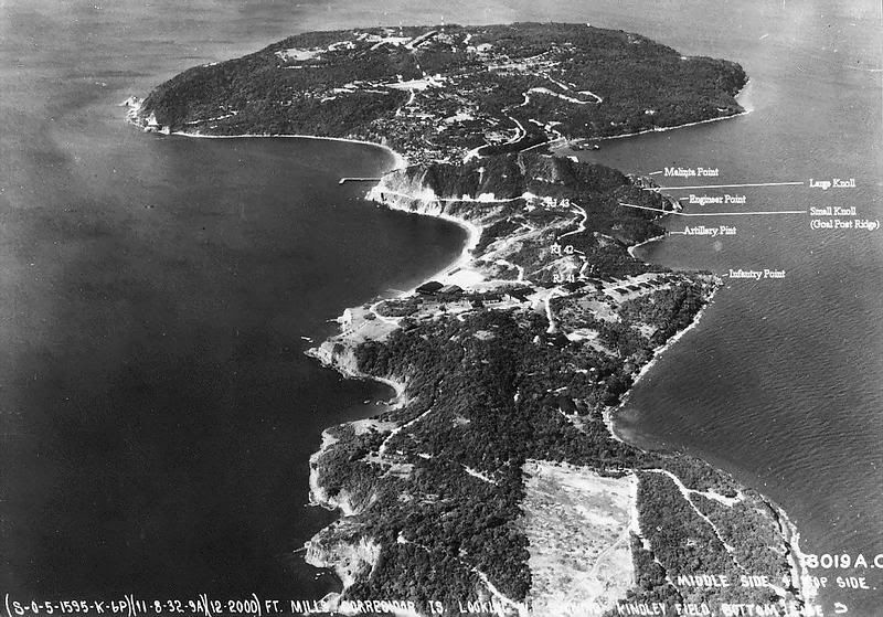
Efforts to determine the exact location of Goal Post Ridge (also called ‘Goal Past Hill’) beyond any doubt has not been successful. Let’s try a stab at logic and opinions for a moment. I will write some comments from the perspective that Goal Post Ridge is between Malinta Point and the top of Malinta Hill.
Note 1: When considering the following points, keep in mind that to get from Bottomside up to Goal Post Ridge is relatively easy, even today. You do not have to go up to the top of Malinta Hill and back down. You do not even have to go around Malinta Point first and then up the ridge.
Start at RJ70 on Bottomside and follow the road to the low section of the ridge adjacent to (SE of) Malinta Point. Swing to the right skirting the little cliff and scramble up to the ridge. Once here it is non-stop to Goal Post Ridge a couple hundred feet further.
Note 2: With the exception of some snipers early on, the western slope of Malinta Hill is under US control. Movement was dangerous for awhile but soldiers went up and down the hill numerous times.
If Goal Post Ridge was between Malinta Hill and Malinta Point:1. Goal Post Ridge looks directly down onto Bottomside. Reinforcements could get up here from Bottomside quite easily so why was it said to be isolated? (The elevation here is half of what it is at the top of the 395ft hill).
2. Why drag a wounded man up to the top of Malinta and then bring him down the same side of the hill again to medical care on Bottomside? Bring him down directly...shorter trip, faster and easier.
3. After ‘I’ Company relieved ‘K’ Company on the top of Malinta Hill, a body recovery team of ‘K’ Company soldiers went back to Goal Post Ridge. Why did they go to the top of Malinta Hill first and then back down to Goal Post Ridge instead of taking the much shorter route directly from Bottomside?
4. At times the Japs occupied Goal Post Ridge and could fire directly down onto nearby Bottomside which was in clear view. The US soldiers there facing west towards the Ice Plant would have their backs to the Japs and be easy targets. The US soldiers would be right under their noses. As time progressed Bottomside would be loaded with ripe targets of more troops, supplies and vehicles that continued to come ashore.
The Japanese were aggressive as demonstrated in other attacks at the time! Hundreds of them flooding down onto Bottomside from Goal Post Ridge would have caused havoc. Do you believe that they looked directly down onto Bottomside and never took advantage of that situation?
5. The 175 ft hill has numerous foxholes (by far, most are facing east toward the tail of the island). Goal Post Ridge has none. Why?
6. Why can you not see goal posts in any of the 1945 hi-resolution invasion day photos? They should be clearly visible since they were sticking up 10 to 12 feet above the barren hillside.
7. As you descend the ridge from the top of Malinta Hill, it soon levels out for about 150 feet. From then on the ridge continuously slopes down to Malinta Point. Some sections are steeper than other parts but it is always a downhill walk. There are no higher and lower hills as the written accounts describe. Note the 5ft. contour interval maps to confirm this.
8. Two old maps show US penetration on invasion day to be as far as the 175 ft ridge. No maps show the penetration that day to be no further than Malinta Point. Why?
9. Comments about them getting sniper fire “from Infantry Point 150 yards NE of his position” must be wrong.
10. 3rd Platoon was positioned up on top of Malinta Point. They had an excellent view looking east along the northern side of the ridge between them and the top of Malinta Hill.
When contact was established with them a few days after the battle started, did they report seeing dozens/hundreds of Japanese troops on the ridge (Goal Post Ridge) between them and the top of the hill or just say they only had two attacks which resulted in three walking wounded? They said they were having fun picking of some Japs trying to fill up their water jugs from a distant spring.
Let’s keep an open mind for a moment. Re-read the above points considering that Goal Post Ridge was located on the 175ft hill. How many points fit that location?
Karl, some of the tunnels Valtin mention cannot be the Navy tunnels. On embarking from the landing craft, the soldiers dashed a couple hundred yards directly across the island before starting to ascend Malinta Hill. Third Platoon was sent further north toward Malinta Point.
The Navy Tunnels, as you know, are along the SW side of the island. I cannot believe that the soldiers tasked with getting to Malinta Point headed back toward the south, walked by the tunnels and then walked by them again heading north to get to Malinta Point. This makes no sense. Photos from 1945 show these tunnel entrances buried anyway.


Note that the 5 Navy tunnels are all buried in February, 1945.
An aerial photo taken that morning shows soldiers simultaneously heading up Malinta Hill AND heading towards Malinta Point, not back towards the Navy tunnels.
Normally this would be the end of today’s discussion. How much further can we go since no matter what we read, none of us were there at the time.
We cannot ask Col. Bunker about his tunnels. We cannot ask Gen. MacArthur about his orders but guess what? We CAN ask Paul Cain about Goal Post Ridge! He is alive and living in Urbana, Illinois.
I got his home telephone number, fired up my SKYPE program and within one minute I was talking to the former commander of ‘I’ Company, 34 Inf Regt. Finally, here was an opportunity to speak to a man who was not only there, but an officer making command decisions on top of Malinta Hill at the time in question.
We had a chat for a bit and I explained my interest in Corregidor focusing on his experiences at Goal Post Ridge. Quite understandably, some of his memories are very strong and others range from a bit fuzzy to non-existent.
So that there would be no misunderstanding, I sent Mr. Cain a map with some numbered areas. I asked him what number corresponded to the location of Goal Post Ridge. His answer: he remembered it being located on the ridge between the top of Malinta Hill and Malinta Point. Now we know for sure. End of story and mission accomplished.
Fortunately or unfortunately, however you look at it, I decided to take this opportunity to ask more questions. Everything was going well until a big red flag went up. I asked him what he could see going on down at Bottomside from there. His answer, “We could
not see Bottomside from up on Goal Post Ridge”.
How could he be mistaken about this? He had fought from Black Beach across Bottomside to the North Dock area before being ordered up onto Malinta Hill to relieve Company ‘K’. He had lost men down there! Wouldn’t you think that he would remember seeing where he had just come from?
Digging further, I asked him what route he took when going from the top of Malinta Hill down to Goal Post Ridge. The answer was “several routes” but he does not remember the details. “Several routes” could apply to the 175ft hill but not down the narrow ridge towards Malinta Point. Other answers to my questions could apply to either location.
Mr. Cain is confident that Goal Post Ridge was down Malinta Hill towards Malinta Point but also adamant that he could not see Bottomside from there. It is not possible for both statements to be correct at the same location. I was a bit disappointed that this issue was not going to be resolved beyond any doubt.
It was quite interesting though to hear about some of his experiences during that time on Corregidor. He has stories that are not included in his account of events that we have read.
A big thank-you to Paul Cain for speaking with me and sharing his memories from so long ago. He is doing quite well these days for a 96 year old gentleman and a great guy to talk to. Since the first conversation we have spoken a couple other times and exchanged quite a few e-mails. I have sent him war-time and recent photos of the area where he spent nine dangerous and exhausting days in February of 1945.

(Paul J. Cain - Drafted a Private in 1940, commissioned a 2nd Lt. in October 1942, joined ‘K’ Company 34th Inf Regt 24th Infantry Division on Oahu in November 1942, transferred to ‘I’ Company 34th Inf Regt as Commanding Officer in November 1944. After Japan’s surrender in August 1945, he was relieved and returned to the States in November 1945).
(Paul’s own description of his service record: “
I was drafted for one year in February, 1940. Pearl Harbor kept me with the Army. Was a mess Sgt. followed by Infantry OCS. Joined the 24th Inf. Div in Oahu then to Australia, New Guinea, Biak, Leyte, Luzon, Subic Bay, Corregidor and fighting in Mindanao when the Japs surrendered. Took part in 5 beach landings, 3 in the assault wave. Awarded a Silver Star, and 3 Bronze Stars”.
‘
Valtin’ VS ‘Cain and company’
I
do think Valtin believed that Goal Post Ridge was up from Malinta Point. Since his book published in 1946 was one of the first (or the first) post war account of that fighting, subsequent authors have quoted him. Right or wrong, history has been guided along his path.
A 1947 advertisement for his book has the following description:
“Valtin was granted access to the official field reports, and to the material which he and his fellow soldiers of the 24th Division Public Relations Office gathered by themselves. Out of this material he has woven a remarkable story of the men of an infantry division in combat”. ($3.00 Order Today). Yes it is a good story and interesting reading.
The Acknowledgement by Valtin at the front of his book states
“I have made use of notes generously supplied to me by my fellow combat reporters in the 24th Infantry Division. I herewith express my appreciation to… (he lists 8 men) … , all of whom risked their lives to gather the factual raw material for this book. Acknowledgement is also made to Lt. William D. J. Gordon for detailed first-hand data on the Division’s operations on Bataan and on Corregidor”. (Many names are mentioned in both battle accounts but none of them match anyone listed in this Acknowledgement.)
When I re-read his book about the action in question I see lots of “
we did this” or “
we saw that” etc. The accounts of the action on Corregidor are written in the way a football fan who never leaves the La-Z-Boy talks about how his team won the championship. Offline discussions and searches cannot confirm that he was even on Corregidor at the time.
On the other hand we have the account of a Company Commander who was on the Malinta Hill during this battle. Twenty years ago in 1991, he along with “
several others who were on Corregidor with us at the time” created their own written record of those events. This was a collaboration of ‘first person’ accounts. It is not as detailed as Valtin’s text but I know which document I consider to be more credible.
Valtin’s text is like a jig saw puzzle with the pieces out of order. Using such a book to answer our questions is impossible if irrefutable accuracy is our quest.
Final comment: Valtin primarily wrote about ‘K’ Company. Paul Cain was the commander of ‘I’ Company. The two companies certainly did interact on Malinta Hill (and most likely before and after Corregidor). Paul Cain never heard of PFC Richard Krebs aka Jan Valtin during the war.
Conclusion:
The objective of the 34th was to create a line across the island from North to South to prevent the Japs from getting reinforcements from the east to Bottomside and further west. At no time did I read that they failed in this task.
The US troops on the southern part of Malinta Hill seem to have experienced little action when compared to their counterparts further north. Soldiers on the top of Malinta fought off numerous attempts by the Japs to occupy the hill and they held the line. Soldiers on Malinta Point fought battles and also held the line. A pocket of soldiers in the buildings just east of Malinta Point stood firm too.
The only spot which exchanged hands a couple times was Goal Post Ridge. If Goal Post Ridge was between Malinta Point and the top of the hill when the Japs occupied it, then the 34th’s line would have been broken. If the line was broken, even temporarily, then I expect this significant event would have been noted in the books and by Mr. Cain.
Being in such a strategic position, did the Japs pour down the short distance to Bottomside? No. Did they at least ambush the US troops in plain view down there? No. Why? Could it be because the Japs were not there due to this NOT being Goal Post Ridge?
Previous to this exercise I was open to the possibility of Goal Post Ridge being at either location. That has not really changed. With the two old maps, a bit of logic and (some of) Paul Cain’s comments etc, I think the likelihood that Goal Post Ridge was the 175 ft hill is still quite possible. At this location, the hill’s occupation by enemy troops would not have been a breach the 34th’s North-South line. Still, I cannot say with any certainty exactly which of the two locations was Goal Post Ridge.
The Japs generally fought at night, the 34th moved in the daytime. I think it is believable that pockets of US soldiers were isolated for a few days past Malinta Point at the group of buildings and at times on a hill further east. These groups would certainly be in ‘Indian territory’ until the US attack in force that finally cleared the area. Was the furthest of those two hills in this area the actual Goal Post Ridge? The jury is still out.
If anyone else wants to take a crack at this, help yourselves.