|
|
Post by okla on Apr 10, 2011 20:37:20 GMT 8
Hey Fots...According to the black and white photo, that cemetery is much more extensive than we originally thought. This whole cemetery area intrigues the he11 out of me. Is it the "official" Corregidor Cemetery for Scout dependents, or any civilians living and working on the "Rock"  I have never understood the status of "civies" located on Corregidor. Could just anybody living in Manila, Mariveles,etc just pick up and relocate to the Island and look for work,etc??? Also the man sitting adjacent to the grave looks to be military to me. Do I detect chevrons on his sleeve?? Maybe my too vivid imagination is taking charge in this regard, but those are certainly GI mess utensils at his side. Interesting photo this. Lastly, the photo of Fort Hughes is rather eye catching. Odd how, sometimes, shooting maybe the last shot on the film roll is the best one of the bunch. Betcha this photo of Caballo was just that. Shoot it and get the roll processed. Good stuff as per usual. Cheers. |
|
|
|
Post by fots2 on Apr 11, 2011 8:30:51 GMT 8
Hi okla,
You have some very good questions there, I wish I could answer them for you. Perhaps others can help us know more about these Tailside cemeteries. That certainly looks like a soldier sitting there to me.
|
|
|
|
Post by The Phantom on Apr 12, 2011 5:11:43 GMT 8
Okla, there were other Cemeteries on the island, a few already mentioned.
A civilian cemetery was in San Jose near South Dock prewar.
It was east of the present Hotel run beach/ bar/ restaurant,( close to the south dock itself), 50 yards from the ZIP LINE.
There are no markers or any trace of this location.
I have looked for it several times but the whole area was bulldozed after the war, and a lot of earth from Malinta Hill was pushed down hill covering part of it.
There was a Crematorium at the extreme eastern end of the cemetery, that part is under 30 feet of debris as mentioned above.
None of the PRESENT DAY workers knew of the cemeteries location so close to where they now work.
On the 1921 map, THANKS MAP MASTER, this crematorium is labeled CREMATORIUM, BARRIO.
(This cemetery is still posted on my 1936 map also in it's same location.)
As are 2 highly identifiable, bordered, cemeteries on the tail, with some distance in between them.
One of these cemeteries is inside the road system which loops around the tail here, it is the northern most cemetery.
The second, more southern cemetery is assessable only down a path/dirt road.
The cemetery above, and east, of 92nd garage area is not noted with boundaries as all the others mentioned are.
It simply says CEMETERY over a indistinct area on the map.
This is an area fots and I explored extensionally but found no signs of a cemetery.
As fots previously noted, we did find many hastily prepared gun positions facing the beach area of 92nd Garage area, all along the top of the hill in pretty deep brush.
Old paths and sidewalks down to 92nd were also noted as mentioned by fots.
I poured over my 1936 maps and find no other cemeteries noted, although I saw someone has found another?
There were unofficial American and Filipino cemeteries all over the island in 1942 as the Japanese had the Americans bury them where they found them, (or burn the bodies where they were found depending on who you read or talk to.)
Note: flash point issue.
The hole in the middle of the cemetery, more interesting all the time.
What did they bury there, 12 ft down, long recovered?
|
|
|
|
Post by okla on Apr 12, 2011 6:03:26 GMT 8
Hey Phantom....Thanks for the info. I assume that any military (American) deaths prior to the War were usually interred at Fort McKinley. I would also assume that some of the deceased were returned to the USA under certain circumstances. Wartime deaths, as you stated, were handled in a chaotic manner, i.e, burning, buried on the spot,etc. As I have stated, all these civilian burials have me puzzled. Are they Scout dependents only, residents employed by the military, domestics, shop owners, laborers, Bilibid prisoners,etc. As I mentioned to Fots, I have never really understood the status of civilian residents of the "Rock". Was official permission required to live and work on Corregidor or could folks just come and go as they pleased. The island was a Military Reservation, but San Jose was a Barrio with, as I understand it, civilian run (owned???) dance hall, bars, market,etc. I wonder if these establishments were licensed or "free lance" operations that could be established, bought, sold, traded, etc between civilian business people. Little things about Corregidor gnaw at me and there seems to be no end to new stuff popping up. I hope they continue to surface so Fots, you and others can keep my "addiction" fed. Thanks again for the new poop. Cheers. Postscript...That 12 foot pit does raise questions, doesn't it.
|
|
|
|
Post by beirutvet on Jul 25, 2014 11:30:20 GMT 8
Hey Fots2
In your Field Notes section you asked about the translation of one of the headstones, you wanted to know what S.L.N. meant. It stands for Suma-Langit Nawa, inTagalog it stands for May Your Soul Go To Heaven. It is their version of Rest In Peace.
The last two lines are ALA-ALA NG IYONG ASAWA AT MGA ANAK, Which means "In Memory Of You From Husband and Children". So the woman buried there was both wife and mother to MORE than one child.
Hope that helps
|
|
|
|
Post by dmether on Jul 26, 2014 16:11:27 GMT 8
These are 1937 numbers: 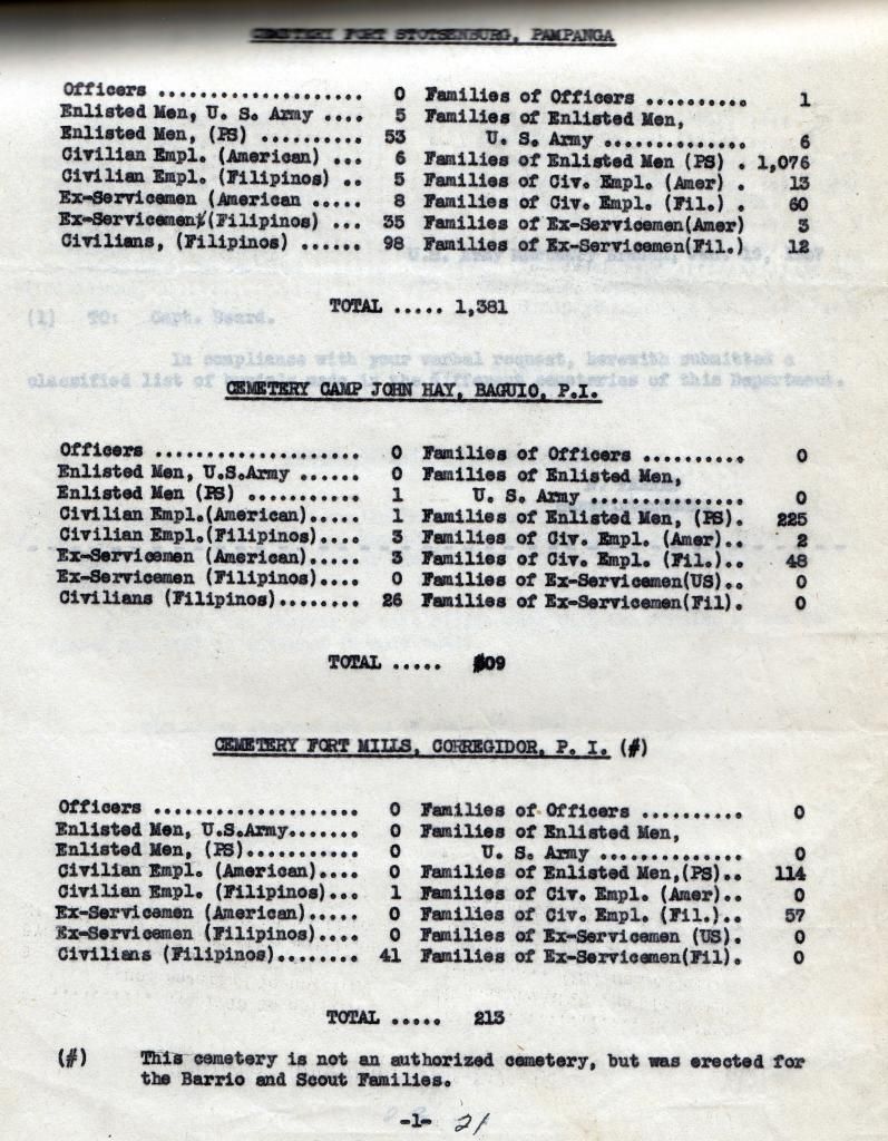 |
|
|
|
Post by fots2 on Jul 27, 2014 2:04:01 GMT 8
Thanks beirutvet for the info and thanks to Dave, I have not seen that list before.
|
|
|
|
Post by The Phantom on Jul 27, 2014 7:34:17 GMT 8
dmether, an interesting typewritten list.
Do you know its origins?
Do we know which Cemetery on Corregidor it refers to?
There was a Cemetery, probably the first on Corregidor, in Barrio San Jose for a time, on the southeast corner of Bottom-side, (with it's own Crematorium for a time), This cemetery probably originated with a Spanish Convent that was on Corregidor in early Spanish times located in that same area.
Corregidor was also used as a recovery area for the convalesce of Spanish troops with malaria and other tropical issues.
Those that died may have been buried there early on or cremated and sent home?.
This cemetery was moved and there is no trace of it today.
The present day concrete roads from South Dock to the north of Bottom-side runs right though it old boundaries.
There was a Cemetery next to the 92nd Scout Barracks above 92nd Garage beach area on the eastern bluff, in the turn of the road out from 92nd Garage beach area.
There was a path from the shoreline, going behind the hangers, that went up the hillside on the east slope, and into that Cemetery. This was a possible a way to get to that cemetery by banka without going onto the military reserve.( This pathway up the hill is mentioned in books as the way some troops from the south east beach defenses, went to surrender after the white flags were flown on top of Malinta Hill)
This Cemetery was also moved.
There were 2 separate and distinct Cemeteries on the Tail near its end also ,shown on the 1936 map as crosses.
Were the graves from the previous mentioned cemeteries moved to the Tail-side existing Cemeteries before the war and at what time, does anyone know?
There is also talk of another unauthorized Cemetery by Barrio Lourdes..........a former scout Barrio.
The U.S. Army Crematorium was located below Battery Ramsey, and was a substantial structure.
And was there cold storage for the dead, developed after refrigeration, and was it located for U.S servicemen, to be shipped home, under Skipper Hill?
|
|
|
|
Post by dmether on Jul 27, 2014 16:48:13 GMT 8
Phantom: I went to the US National Archives to research AGRS in the PI in WWII, this was found in one of the boxes, really no other info other than what the list shows.
|
|
|
|
Post by beirutvet on Jul 28, 2014 4:37:36 GMT 8
Hello Fots2
Looking at that headstone mentioned above, I do not think it says Trinidad Reyes USA. If you look at the "A" in Trinidad, you will see a dramatic slant in both left and right sides of the letter. The "A" in "USA" does not have the slant on the left side, it is fact straight up and down. If it were an "A" wouldn't you think it would be identical to the "A" in the rest of the name? It seems also to have a tail at the top left similar to that found in the "E" of "Reyes".
Take a close look at that area and it looks like a chunk of the stone has been removed (battle damage, perhaps?). If it does have a piece of the stone missing, we may never know the full name of the woman who rests there. Do you have another picture of the stone, perhaps at a slightly different angle? If you do, we may be able to surmise which letter it is after the "Us". Sometimes light and shadow from different angles can give us a different perspective and reveal things previously hidden.
Your thoughts, please.
|
|


 I have never understood the status of "civies" located on Corregidor. Could just anybody living in Manila, Mariveles,etc just pick up and relocate to the Island and look for work,etc??? Also the man sitting adjacent to the grave looks to be military to me. Do I detect chevrons on his sleeve?? Maybe my too vivid imagination is taking charge in this regard, but those are certainly GI mess utensils at his side. Interesting photo this. Lastly, the photo of Fort Hughes is rather eye catching. Odd how, sometimes, shooting maybe the last shot on the film roll is the best one of the bunch. Betcha this photo of Caballo was just that. Shoot it and get the roll processed. Good stuff as per usual. Cheers.


