|
|
Post by okla on Oct 3, 2010 23:41:54 GMT 8
Hey Chad...Many thanks for posting those pix of the "Pockets" area. That's gotta be Trail 7 as you so stated. It would appear from the third pic that there has been extensive clearing over the years by the locals. John Toland stated in his 1960s book, "But not in Shame", that he had great difficulty, even with native guides, in locating the Tuol River since the landscape was so different from 1942. Such a large number of enemy troops infiltrating our positions had to be attributed to dense undergrowth and this stuff helped the Japanese survivors to retrace their steps in escaping the allied counter attacks. I have read/heard the the fighting here was close quarter, "belly to belly" stuff, but our guys prevailed. The "Pockets" battle doesn't get near the print that Abucay and the "Points" have received, maybe for that very same reason. Nothing unique or dramatic about it, just close up, cutting and slashing, eye ball to eyeball. Thanks again for the pix. Postscript....Isn't that Mount Bataan looming in the mist in the last pic?  |
|
|
|
Post by chadhill on Oct 4, 2010 0:04:11 GMT 8
Okla, Mount Bataan sure is looming back there. I'm glad you mentioned Toland's book. That reminds me of a question that I've had for years about the Abucay Line. Can anyone answer it?
The late John Toland visited Bataan while researching his 1961 book "But Not in Shame". On page 411, in the notes for Chapter 12, Toland writes "I traveled the entire length of the Abucay Line on Bataan by truck and foot. The long trench, reminiscent of World War 1, is still there. Several farmers have built their nipa shacks directly over it".
Is this massive trench still there? I did not see it in the 1980s.
|
|
|
|
Post by okla on Oct 4, 2010 4:35:30 GMT 8
Hey Chad....Till you mentioned it, I had forgotten about Toland mentioning the "trench". Wonder in which Regimental sector this feature was located. Vic, the Philippine Scout Website "honcho" has prowled the Abucay Line about as much as 'ole Fots has crawled around Corregidor. If anybody would know the location of the trench, it would be Vee Vee. After this many years (especially with people building living dwellings,etc over it) I can see it having disappeared, but on the other hand the Western Front in France still has very visible evidence of trench works. I guess it would depend on how extensive a fortification it was,i.e. whether it was sandbagged, how deep it was,etc. That Toland book (as are all his efforts, in my humble) was a "goodie". I have read it several times and go to it often to refresh my memory on certain things. Cheers.
|
|
|
|
Post by victor on Oct 4, 2010 9:48:39 GMT 8
I'm guessing the trenches would be closer to the barrio of Mabatang if farmers built nipa shacks over them. The MLR paralleled a road that leads to Mabatang. (click for bigger)  It might also be around the 41st Division's (PA) area. I remember reading a book about the 41st Division written by one of their officers who later became the Phil. Army chief of staff in the 1960's. He mentioned having to recommend building trenches instead of foxholes after the initial engagements because it improved the morale of the soldiers to be in the same hole as some of their comrades. I have some pictures of the Mabatang area here: pinoyhistory.proboards.com/index.cgi?board=photos&action=display&thread=143 |
|
|
|
Post by chadhill on Oct 29, 2010 10:28:12 GMT 8
This photo of Japanese troops on Bataan is from "Philippine Expeditionary Force", by Gasei, published by the Japanese in occupied Manila in 1943. The translated caption says, "The extensive battlefields includes such places as bamboo groves, rivers, ravines, and mountains. The operations on Bataan took place in such surroundings. Where there are no roads guns are disassembled and carried to the front, through jungles so thick that one cannot see thirty feet to the front"...  |
|
|
|
Post by okla on Oct 29, 2010 22:56:20 GMT 8
Hey Chad...When viewing this photo I couldn't help but wonder if this might be a shot of Japanese troops flanking the original MLR, either on Wainwright's right or Parker's left. But since those events were early in the actual Bataan Campaign the Japanese PR folks may not have really been "into it" yet, thus, methinks that this pic is more likely from the Samat breakthru,etc. Hell, since the foe was so good at "recreations" etc, in producing propaganda films and such, this photo may have been taken on a training exercise up in Formosa or some such locale. Here I go thinking too much again. It is an interesting photo though. Keep the good stuff coming. Cheers.
|
|
|
|
Post by victor on Nov 23, 2010 23:21:54 GMT 8
|
|
|
|
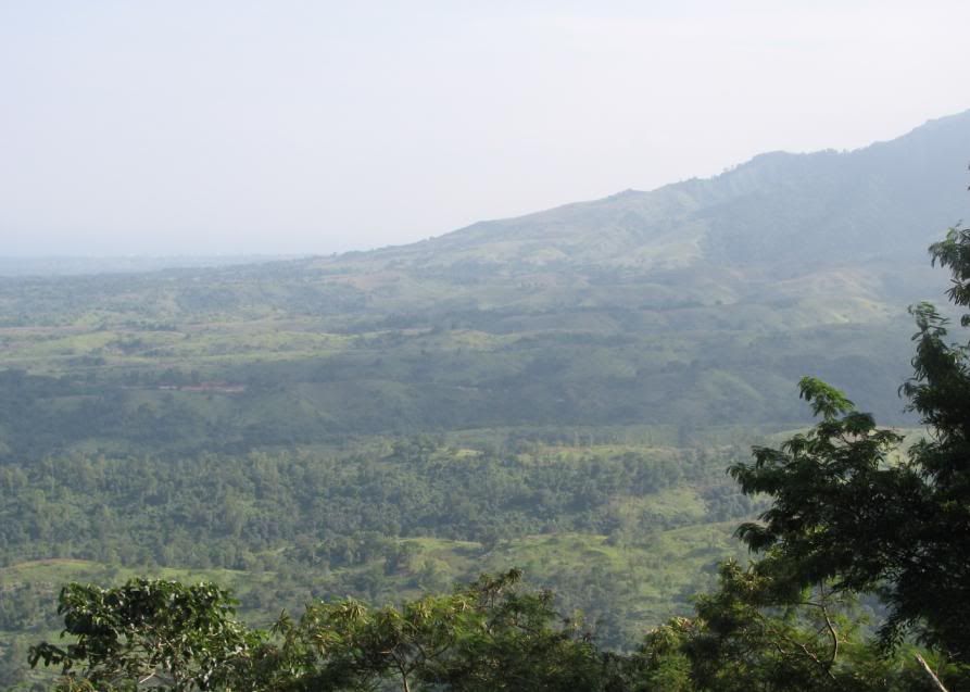
Post by fots2 on Nov 24, 2010 0:56:32 GMT 8
Hi Victor, Here are a few photos from Mount Samat looking in the same direction as your 1941 scanned photo. Captain Olson may have been further to the right than I was but the view is similar. We are looking almost south towards Mount Limay. Part of Manila Bay can also be seen towards the left. I’ll add a few more photos panning left to show more of the bay.  1 - Your scanned photo darkened a bit.  2 - Similar view of Mount Limay without the peak covered in clouds. Unfortunately at the time I was taking photos of the guns and not more of the valley.  3 - Looking a bit towards the left. It was hazy and cloudy at times that day. I took this and the next photo at a slightly different location than photo #2.  4 - More to the left.  5 - Mount Limay. |
|
|
|
Post by okla on Nov 24, 2010 4:13:41 GMT 8
Hey Fots...Thanks for posting these pix. They just reinforce my mental picture of just how rugged the terrain was on Bataan. What a great defensive position it was. Makes one wonder just how long our guys could have held out with adequate food, medical supplies,etc. Forgive me, it's the imagination stirring. Cheers.
|
|
|
|
Post by chadhill on Nov 29, 2010 6:00:37 GMT 8
|
|