|
|
Post by fots2 on Jul 15, 2012 17:01:24 GMT 8
Hi Chad,
I agree, that is a late morning photo. I should have known better as shadows appear on the east side of Malinta Hill in the afternoon. I’ll stick with the rock story though until evidence of something else shows up. I can see what you see but I think it is just the poor quality photo. What we need is a high resolution 1932 or shortly after photo of this area. There are no remnants of concrete pedestals of any sort at this location but 80 years and a world war since the photo was taken, that is not conclusive.
These details are interesting to ponder though, thanks for the ideas.
|
|
|
|
Post by fots2 on Jul 14, 2012 22:15:46 GMT 8
Hi Chad, To my knowledge there never was any tall object on the beach. In fact there is very little beach at all as the south side Malinta Hill cliffs go directly into the water. Moving eastward there is a narrow beach but I see nothing in old photos there either. From the shadows on Malinta Hill I can tell that this old B&W photo (looking in a westerly direction) was taken in the afternoon. That would put the sun shining down from the upper left corner of the photo. I have a feeling that what appears to be a tall object is actually a shadow behind a piece of jagged rock. Of the four air vents inside the Malinta tunnel complex, three are still concrete lined. However, the fourth is bare rock from inside the tunnel all the way up to the surface. The story is that this is the air shaft that in 1945, US soldiers dumped gasoline and hand grenades down the shaft in an attempt to get the Japs out. The resulting explosion and fires destroyed the concrete lining. The whole area near this shaft is still rough and charred. Have a look at the photo below and see if it brings back any memories. You cannot see sunlight when standing on the floor inside the tunnel. I have never been up the shaft but there appears to be a bit of a ledge approximately 20 feet up. From there the shaft turns right somewhat and I bet you can see the surface from there. (I say this because when looking down, it looks straight until a turn near the bottom). There is also some twisted rebar inside the shaft near the surface that you may have been able to see. 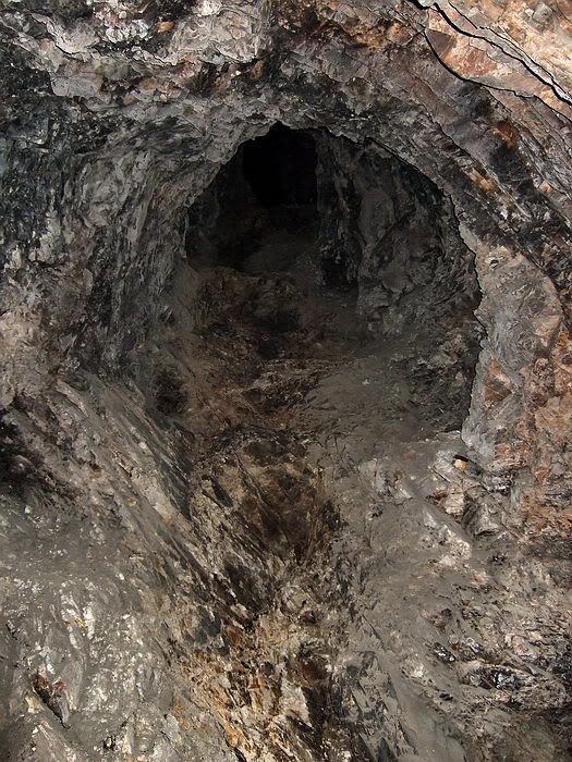 Standing on the tunnel floor and looking up the air shaft. I always thought that with a rope it would be no big problem to pull myself hand over hand up this air shaft. The distance from the ledge to the surface would be much longer than the first 20 feet though. This air shaft is probably the one you are thinking of. It is the SW air shaft so not in the eastern part of the tunnels. I wouldn’t be concerned about that though, your memories from a onetime visit 30+ years ago are very good. In Reply #147, on the map you show a red arrow that is supposed to be at the East entrance. The arrow is on the South Shore Road and should be a further East where the single line (the main tunnel shaft) touches the road and trolley line. i.e the South Shore Road passes over the top of Malinta Tunnel at this location. Your tunnel length figure (close but not exact) should be coming tomorrow. |
|
|
|
Post by fots2 on Jul 14, 2012 19:11:59 GMT 8
Armyjunk, I have not seen this blueprint before, very interesting. Like La Monja Island, it seems there were big plans for Malinta Hill at that time. That would have been fun exploring for sure. On the Corregidor 1936 (5’ Contour Interval map), the top of Malinta Hill is within a circle labeled 400’. The sketch shows 401.3 ‘ (or .9) so it is certainly believable. The East and West entrance elevation figures disagree a bit but we do not know what is actually correct. I played around with contrast etc on the blueprint and added some clearer labels for you. Thanks for posting this. 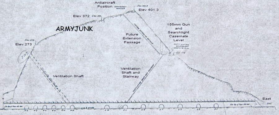 |
|
|
|
Post by fots2 on Jul 14, 2012 2:42:29 GMT 8
For okla and anyone else interested, I made a rough video as I walked through part of the Malinta Hospital tunnels to give you an idea of what it is like in there. The map shows the route that I recorded. 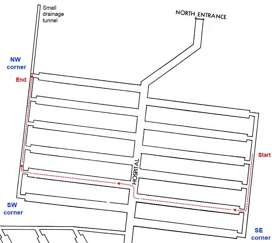 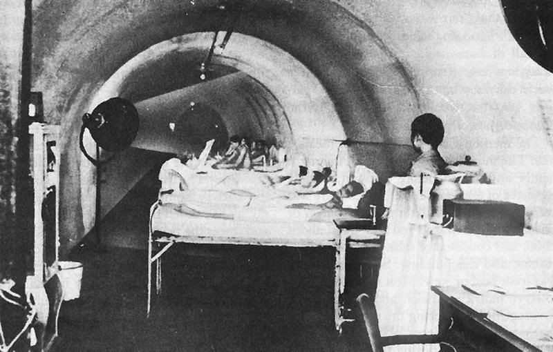 1942 photo of the hospital in operation. (armyjunk and Chad, I will reply to you soon) |
|
|
|
Post by fots2 on Jul 13, 2012 7:35:31 GMT 8
Chad, You are probably as close as we are going to get with those elevation figures. Accurate elevation measurements can wait until you and okla arrive to take them. ;D It would be great to wander around with you guys.
All air vents have a similar angle up to the surface.
It is 7:35am here so I will head over to the tunnel now. I will get back to you later.
|
|
|
|
Post by fots2 on Jul 13, 2012 0:52:47 GMT 8
Hi Okla, Since we both have the same Corregidor addiction then it make sense that we share an inability to write about it at times.  Occasionally I do make fun of the day tour crowd. They enjoy doing what they want though and I do the same. Actually considering many places I visit on the island, I rarely see them during the day. If our paths cross, I just wait 10 minutes and they are gone. ;D |
|
|
|
Post by fots2 on Jul 13, 2012 0:07:42 GMT 8
Hi Chad and okla,
Getting accurate height/altitude measurements of the east and west portals is beyond my capabilities here. Last year I bought a new GPS so I took some updated waypoints today. Old GPS, new GPS, the 1936 map and the “The Hard Way Home” map readings of the three portals vary so much that I won’t even suggest what may be correct.
As I was walking today I thought of one error I told you in my post #141 where I said “When I walk from the East portal to the North portal I do not feel a change in elevation at all however the maps show a difference of 10 feet”. (An example of thinking one thing and typing something else I guess).
What I should have said is I do not feel any change in elevation when walking from the main East-West tunnel at Lateral #1 to the North portal. Note that from this intersection I am not counting the distance (and slope) from the East portal and the Lateral #1 intersection. When you consider this, the North portal definitely is lower that the East portal.
I have also read the Malinta Tunnel length figures you mentioned but do not have the actual figure recorded. Tomorrow morning I will walk over to the tunnel and get you a ‘reasonably’ accurate length of the main east-west tunnel.
This afternoon I made it down off the hill in time to see the final “day tour” crowd pass through Malinta Tunnel before being dumped back on the ferry. After that, the tunnel was mine so I spent 2 ½ hours wandering around.
The 4’x6’ ventilation passageway numbers shown on the map are closer to what you see in the East-West shafts at the ends of the main tunnel laterals. Often though, a height of only 4 feet is quite common. The ventilation passageways at both ends of the Hospital laterals are huge compared to this which makes the map incorrect.
Here are some estimated heights/widths in the Hospital for you.
Main North-South tunnel = 12’ high x 12’ wide. (concrete lined)
Laterals = 8’ high x 9’ wide. (concrete lined)
Ventilation Passageway (West side) = 15’ to 25’ high x 18’ wide. (unlined rough rock)
Ventilation Passageway (East side) = 20’ to 25’ high x 18’ wide. (unlined rough rock)
There are only four air shafts as mentioned earlier. The NE corner air shaft is one straight shaft up to the surface at approximately a 60 degree incline. I can see sunlight at the top. No “V” shape.
I cannot find evidence to support the second map showing so many washrooms.
Whenever I get around to it I will make a trip report on Malinta Tunnel, for some reason that place fascinates me. No ghosts or snakes today but I did have an Alfred Hitchcock moment. I walked around a corner and my flashlight startled about a thousand swallows building nests. There are bats in the nearby Gasoline Tunnel but I have never seen so many birds in the laterals before.
|
|
|
|
Post by fots2 on Jul 12, 2012 10:40:51 GMT 8
Hello Chad,
You have an amazing sense of timing. I am on a short 3 day trip to Corregidor and as I am writing this message, I see Malinta Hill outside my window just 400 feet away. In an hour or so, I will be on top of the hill.
Thank-you for posting “The Hard Way Home” map. I have not seen air shafts shown on any map before either. Here are a few comments about the map:
- It is correct in that there are only four airshafts total for the whole tunnel complex. Their placement on the map is also correct.
- The east and west ventilation passageways of the hospital do exist but are much larger than the 4’ x 6’ dimensions quoted.
- The NE corner air shaft shows a “V” shape on the map but this makes no sense to me. From this corner, you can look straight up a single (estimated 60 degree incline) concrete shaft.
- The Malinta Gasoline Tunnel portal is quite a bit longer than the Malinta West Tunnel portal. They are shown of equal length on the map. The east portal sticks out further than the hospital laterals so the map may just be cropped to fit on the page.
Regarding the second tunnel map you posted showing two additional air shafts (Lateral #2 and #3), they do not exist. There is nothing but solid rock at the end of these shafts. The only way to determine how many air shafts there are is from inside the tunnels. There are only four.
Unless everyone is wrong, the Nurses Quarters was not in the location shown (end of Lateral #1). Today I cannot determine if there are any washroom pipes in this corner as the control room for the Sound and Light Show is located here. Actually I am surprised at all the washrooms shown on the map.
In my humble opinion, the elevations shown at the North portal (83.7ft), the East portal (93.7ft) and the West portal (60ft) are ridiculous. (okla is right on the money again) One author got it wrong and the second one copied the errors. As you walk in the tunnels, you will notice a downward slope (for drainage) as you walk from east to west. In the main east-west tunnel and the hospital laterals this is noticeable.
When I walk from the East portal to the North portal I do not feel a change in elevation at all however the maps show a difference of 10 feet. I have a bit of proof that I am not totally crazy in that I have GPS waypoints of the two entrances. (From what I read, unlike locations, GPS elevation readings are not real accurate but certainly not too far off either). The GPS difference in elevation between the East and North portals is 3 feet.
That is all I can think of at the moment. Malinta Hill is beckoning me so I had better saddle up. If I have time I will refresh my memory on parts of Malinta Tunnel on the way back.
|
|
|
|
Post by fots2 on Jul 6, 2012 22:03:36 GMT 8
Hi Patty, That text is interesting for sure. One thing that comes to mind is Amea Willoughby’s description of the location of the Philippine Treasury building. When someone mentions the Treasury as having been located at Middleside, most people scratch their heads in confusion. We have to remember that there were no defined boundaries to Topside, Middleside, and Bottomside. Personally I consider these three areas to have limits and everywhere else is “none of the above”. In my view, saying that the Treasury was on Middleside is a bit of a stretch but then it certainly is not Topside and certainly is not Bottomside. If we have to pick one, as Willoughby did, then by the process of elimination it is on Middleside. The Philippine Treasury Building is shown on US Army maps to be located in the Insular Government Reservation. To drive here from Malinta Tunnel, you would go up to Middleside and then continue a bit further. Driving time would be about five minutes as she stated. If you were standing at the Treasury building, “a bit higher up on the same hill”, there is a twelve-inch mortar battery. It is named Battery Geary and the straight line distance between it and the Treasury is only 370 meters. There is no question that Battery Geary was a “favorite shelling target” of the Japanese. When Willoughby says the Treasury was not bombproof, we cannot argue with that statement either. In 1945 it took a direct hit and virtually disappeared. Today chunks of broken concrete are all that remains of that building. They drove “to a charming little green bower (a shady, leafy recess) where the vault was snugly hidden under leafy luxuriant foliage”. Here is a pre-war photo of the Philippine Treasury that seems to fit Willoughby’s description quite well. 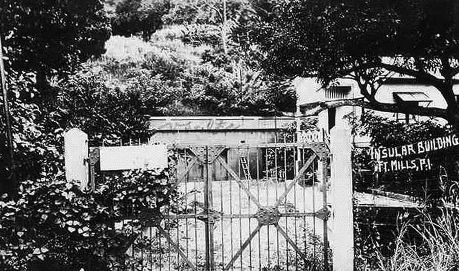 This trip report will show you what the area we are discussing looks like today. corregidor.proboards.com/index.cgi?board=threads&action=display&thread=728Text in the book describing the treasury confirms that is was located where we think it was and that this location was considered to be part of Middleside. Thanks for the post. |
|
|
|
Post by fots2 on Jul 5, 2012 8:17:16 GMT 8
Hi okla,
Happy Independence Day to you and all my State side buddies. The corresponding day here in the Philippines is celebrated on June 12th.
I may be on a first name basis with many of those varmints but it is not a name that should be said in public... ;D
|
|


