|
|
Post by okla on Oct 17, 2010 23:29:34 GMT 8
Hey Fots...Thnx for cluing me in on the correct location of the Officers' Swim Area. Somewhere I had picked the erroneous notion that the brass took their "dips" in the 92nd Garage Area. There's always something new to learn about our "rock". One thing that always jumps out at me, when viewing pix of present day Corregidor from the air or atop elevated areas, is how green the place is as compared to the "moonscape' scenes from 1945. One would never know what devastation was the norm in '45 until eyeballing the "then and now" photographs. Gotta confess I prefer the "nows", don't you. Cheers.
|
|
Deleted
Deleted Member
Posts: 0
|
Post by Deleted on Oct 18, 2010 5:41:17 GMT 8
Hi Fots and All - Thanks for displaying these shots. Paul Cornwall would be proud to know they are being shared! Karol
|
|
|
|
Post by chadhill on Oct 18, 2010 10:30:04 GMT 8
Fots, great view of the barrel damage there. Is that rifling we see inside?
|
|
|
|
Post by fots2 on Oct 18, 2010 16:14:37 GMT 8
Yes it is. When standing there you can easily see the spiral when you look closely at the damaged area.
|
|
|
|
Post by okla on Oct 18, 2010 23:44:02 GMT 8
Hey Fots...I am still perusing these latest "now and then" pix. I am back to Enlisted Men's Beach and have one more comment. Did you notice how today's beach is more rock and pebble strewn as compared to the shoreline shown in the "then" views?  ? I am certainly no Geologist, but I do wonder why the "sandy" composition has given way to the more rugged appearance. Some type of erosion effect over the years, I suppose. Swimmers today had best be wearing flipflops or tennies lest those "bloodstones" have real blood on them. With queries such as this, is it any wonder that Wife thinks that I am about over the edge??? Cheers. |
|
|
|
Post by batteryboy on Oct 22, 2010 12:25:12 GMT 8
This reminds me of a story of bloodstone story:
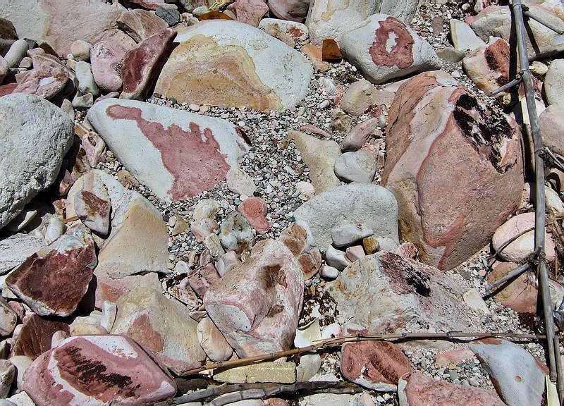
Somewhere in the 1990s a famous tourguide (whom I will not name) emphasized on the bloodstone found in the southern shores and also emphasized the black stones found on a specific location by the north dock. He made this a part of his spiel to the point he mentions that these form part of the mysteries of Corregidor.
Here's the logical explanation:
The blood stained stones are part of the volcanic rocks (not lava) that were discolored due to the earth's own cooking pot. Note that the southern shores of Corregidor and the island of Caballo were part of a caldera of volcano
The black stones found on the north dock were the tourguide pointed a specific location used to be the coal filled basin for the steam ships. Naturally, through the years, the remaining coal blended with the rocks and discolored the location in a sooty black grime. Thus the legend of the black stones.
FWIW,
|
|
|
|
Post by tomasctt on Oct 22, 2010 13:45:38 GMT 8
OT... BB: a few years ago, I was once surfing the net on volcanoes in the Philippines, and I was surprised that Corregidor was listed as such. Further digging in the article (forgot the link already, it was years ago) revealed that Corregidor was the tip of a caldera. Which got me thinking: that has got to be a massive volcano.  I wonder if there are underwater maps (or bathymetric [?] soundings...?) of Manila Bay. I'm terribly curious how it looks like - was Corregidor a separate volcano, or the whole Manila Bay.  |
|
|
|
Post by fots2 on Oct 22, 2010 14:48:57 GMT 8
Okla, batteryboy and tomasctt, Sorry okla, I missed your response. I have never tried but I expect if the rocks were removed today you would find sand. In the past I lived in a house on the beach for a year. I was amazed that sand levels would go up and down by at least three feet due to normal wave action and especially during storms. The occasional visitor wouldn’t notice this. Lack of beach maintenance is just showing uncovered rocks. Factor in 60 to 70 years of erosion and that is probably why we see the beach looking like that now. Here are some of the south shore blood stones that batteryboy speaks of. These ones are dry. When wet, the red becomes a deep crimson blood-like color.  This is a map and not a chart but it seems to show a caldera between Corregidor and Caballo Islands.  |
|
|
|
Post by tomasctt on Oct 22, 2010 19:58:00 GMT 8
This is a map and not a chart but it seems to show a caldera between Corregidor and Caballo Islands.  AHA! Thank you! I see it clearly now. Considering that Mt Mariveles was a volcano before.... Man, I'd love to have a plate tectonic graphic to see if that was a former hot spot (Corregidor first, then Mariveles, then Pinatubo). Looking at it, I'm getting goosebumps. |
|
|
|
Post by okla on Oct 23, 2010 0:03:25 GMT 8
Hey Guys...Always picking up new info on this forum. I didn't realize that "bloodstones" were found only on the South Shore, but this explanation certainly makes sense. From the geological layout of the area, it is a wonder that earthquakes (or the threat thereof) over the years haven't made all that construction on the "rock" a rather risky endeavor. Since the place has survived without any serious incident from mother nature over the years, it would appear that my fears have no basis. Thanks again for the new "poop". Cheers.
|
|