|
|
Post by Karl Welteke on Jul 11, 2020 5:38:44 GMT 8
A Japanese ship under attack in this very clear picture of NAVAL STATION Olongapo on the 19th Nov. 1944. 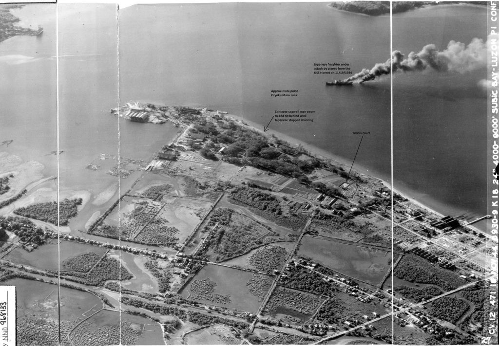 Zo801. A Japanese ship under attack in this very clear picture of NAVAL STATION Olongapo on the 19th Nov. 1944. This picture is curtesy of Tim Hampton, CV-12 Hornet Air Group Eleven archivist. This picture is also uploaded in high resolution in my Flickr album at about 4,000KB, if you like to download it. This is the URL of the image, you got to follow the Flickr steps to download: www.flickr.com/photos/44567569@N00/50098462156/in/album-72157674621084888/It was made available to me thru the Army Lt. Chester K. Britt Research Team: First is Dave Britt, LTC USAF (Ret), son of Chester K Britt, Vickie Graham CMSGT USAF (Ret), and John Duresky. They all graduated from Logan High School in La Crosse, Wisconsin in 1967, and are doing it as a team. Chester Britt graduated from Logan in 1933 and his mother Grace in 1934. Dave wrote most of the manuscript, John editing what he wrote and doing most of the research, and Vickie is the final editor with about 20 years of professional writing in her resume, largely with Airman magazine. You can learn more about the research team project from this URL: corregidor.proboards.com/thread/2275/army-chester-britt-ship-oryokuThis attacked ship is not the infamous Oryoku Maru, it looks more like freighter and it was attacked on the 19th Nov 1944 and not in Dec. 1944 when the Oryoku Maru was attacked and sunk in Olongapo. The Corregidor forum has a very interesting page about the Oryoku Maru, in pictures about the last few days of the ship before it got sunk: corregidor.proboards.com/thread/1601/oryoku-maruOn my hard drive, I have this picture at 23,000 KB, tell if you like a copy. |
|
|
|
Post by Karl Welteke on Oct 11, 2020 2:59:54 GMT 8
Philippine Scouts, Maquinaya Artillery Range, Barrio Barretto, Subic Bay. 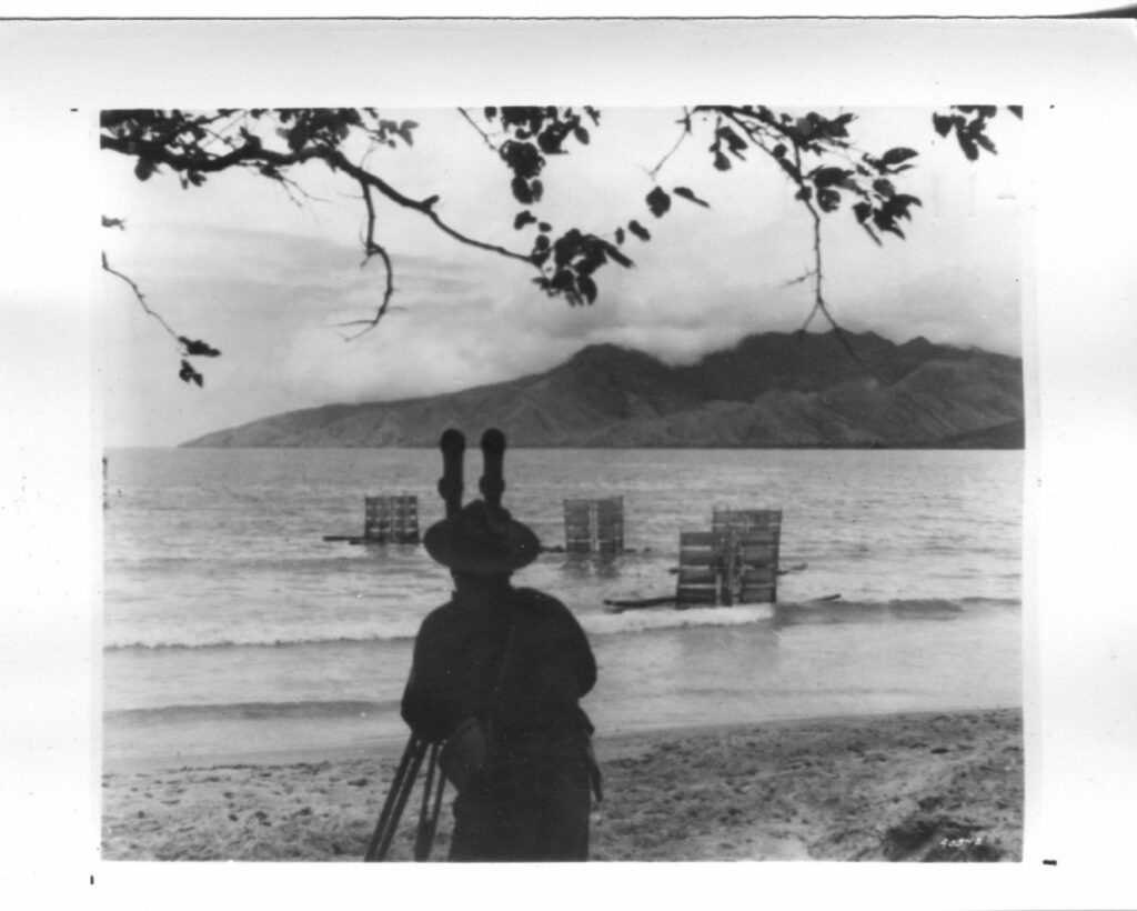 Zd188. Flickr 045. SC-118540. Olongapo, P.I. Sept. 1940. Activities of the 24th Field Artillery (P.S.) during target practice. This picture is from my CDSG Friend Karl Wilhelm Schmidt. Note from Karl: The picture did not have a number but I’m sure the description on another picture jives with the geography. This is what I’m sure of: The picture is not shot from Ft. Wint which was manned by the Philippine Scouts at that time. It is shot from the area that is Barrio Barretto now (Olongapo City), where I live now, and what used to be the Marine Corps Rifle Range, called Maquinaya, the river still has that name. The range was also used for light artillery. I’m 100% sure, the peaks in the distance are from the mountain Cinco Pecos on Redondo Peninsular, separating Subic Bay from the South China Sea. Fort Wint, Grande Island is left and off the picture. This area was turned back to Philippine Authorities, about 1949. In front, at the beach is what looks like target sleds which perhaps are towed by boats. Targets for the Battleships, Cruisers etc. were bigger and were towed by ships like I served on, ARS, ATA etc. The Maquinaya area was also used as the Naval Supply Depot from 1945 to about 1949 and we have 2 picture albums about this area and history: philippine-sailor.net/2018/09/12/barretto-maquinaya-wwii/philippine-sailor.net/2019/12/27/the-u-s-m-c-maquinaya-firing-range-1902-to-1910-bo-barretto-now/ |
|
|
|
Post by Karl Welteke on Dec 20, 2020 8:55:37 GMT 8
The Main Gate Bridge in the SBFZ, the former Subic Bay Naval Base, 2020.  Z04. The Main Gate Bridge of the Subic Bay Freeport Zone(SBFZ) has been closed for vehicle traffic for years, it was apparently unsafe for vehicle traffic. Finally, the Subic Bay Metropolitan Authority (SBMA) came up with the money to build a new one. The project seemed to be stalled but is now finally taking shape as a wide new bridge. Left is the nicely covered walkway for all workers and visitors streaming on and off the former Subic Bal Naval Base, in numbers exceeding the count during our Naval Base time. Photo is courtesy of my long time brown-shoe friend Carlito Pickering. He always reminds me of a scene in the movie Officers and Gentlemen, one of the fathers of the Gentlemen hanging around in Olongapo City. A Shoemart Mall (SM) has risen of the former Lot 21 just on the Olongapo side of the bridge, about 7 stories high, where this photo was shot from. |
|
|
|
Post by Karl Welteke on Jan 19, 2021 13:13:20 GMT 8
Bataan Trip 21-01-15 This was an exploration trip to look at changes in Bataan during the virus crisis, I had to get permission from my Barangay (Village) Captain, the Barangay Medical Department and the Olongapo Police Head Quarters. I have been absent from the Philippines for 15 months and we all have suffered from the Red China Virus for 9 months or so. What has changed in Bataan? 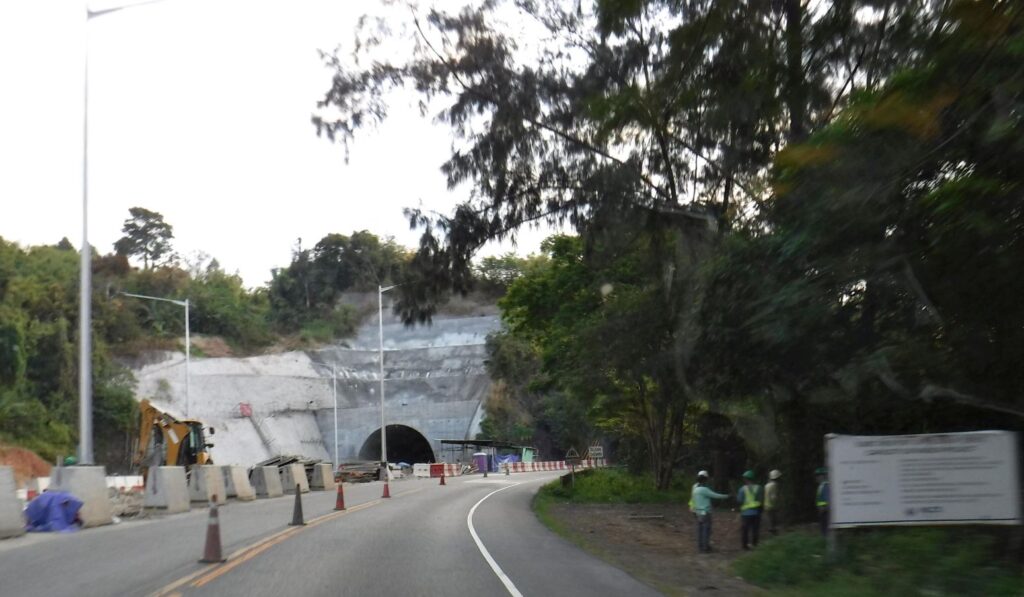 Zd843. This is one of 6 images of the Subic Freeport Expressway on the 15th Jan 2021. Both tunnels are in sight. I used the Subic Freeport Expressway (SFEX), formerly referred to as the Subic–Tipo Expressway to leave the Subic Freeport Zone, the former Naval Base Subic Bay. Wikipedia says this about the Subic Freeport Expressway: en.wikipedia.org/wiki/Subic_Freeport_ExpresswayThe Subic Freeport Expressway (SFEX), formerly referred to as the Subic–Tipo Expressway and NLEX Segment 7, is an 8.8-kilometer (5.5 mi) four-lane expressway that connects the Subic–Clark–Tarlac Expressway to the Subic Freeport Zone in the Philippines. Its alignment traverses the provinces of Bataan and Zambales. I believe the highway is considered over 90% finished and for the recent holydays it was open on all 4 lanes most of the way. There was an accident at the new/2nd bridge over the Jadjad River and maybe slowed down things. I started an album in my webpage but so far I only uploaded the 6 pictures about the Subic Freeport Expressway. Uploaded to the Karl’s webpage, Central Luzon, Bataan No 1 subcategory, Bataan Trip 21-01-15: philippine-sailor.net/2021/01/19/bataan-trip-21-01-15/ |
|
|
|
Post by Karl Welteke on Feb 28, 2021 19:25:12 GMT 8
Just two February observations in the SBFZ.  U775. (#31). The US Navy has not been visiting Subic Bay because of the Virus Crisis. However I have noticed three Philippine Navy modern war ships. I believe the Philippine Navy has acquired several modern units in the last few years and they seem to be home ported here in Subic Bay.  U776. (#32). Left we see the Leyte Wharf, the former US Navy Carrier Pier; it has become a grain port. Right is Cubi Point and was the location of the Navy Officer Beach; it is now a container port. There were no ships in port on that day. |
|
|
|
Post by buster on Mar 1, 2021 9:39:32 GMT 8
Karl, Good spotting the two Del Pilar-class frigates of the Philippine Navy. These frigates were previously Hamilton-class high endurance cutters of the US Coast Guard. Early in 2011, the Philippine Navy announced the acquisition of ex-US Coast Guard Hamilton-class high-endurance cutters under the "Ocean-going Escort Vessel" project through the US Excess Defense Article program. Three were acquired. USCGC Hamilton (WHEC-715), renamed BRP Gregorio del Pilar (PF-15), commissioned 14 December 2011 USCGC Dallas (WHEC-716), renamed BRP Ramon Alcaraz (PF-16), commissioned May 2012 USCGC Boutwell (WHEC-719), renamed BRP Andres Bonifacio, commissioned July 2016. The Hamilton-class is a cutter that was in service with U.S. Coast Guard and was designed to perform anti-submarine warfare, with the capability to find, track and destroy enemy submarines. Speaking of submarines, the CCP has an underground submarine base on Hainan Island on the South China Sea. The South China Sea has become a hotspot for military tensions in recent years. Beijing claims almost all of the 3.4 million square kilometres South China Sea, and since 2014 it has built up tiny reefs and sandbars into man-made artificial islands, fortified with missiles, runways and weapons systems - antagonizing regional governments with overlapping claims. The oil reserves in the area are said to rival those of the North Sea. We can expect the CCP keeps a close eye on the comings and goings involving Subic Bay. I would not be at all surprised that "unannounced" visits there and in Manila Bay have occurred from time to time. That sort of thing happens when the doors are left unlocked and the welcome mat put out.
 How James Bond'ish this is! How James Bond'ish this is! |
|
|
|
Post by Karl Welteke on Mar 14, 2021 19:33:06 GMT 8
Nazasa Ridge Crossing, north one, views from As you know, I like to hike; I’m convinced, that helps me stay young (healthy). I done this hike 5 days after my 79th Birthday, cloudy day, and this time of the year is a perfect time to hike! I thought, I do something different, instead of uploading all the 82 pictures I shot, I just show these two, plus a Google Earth map for your orientation. It was a Sunday, some things I learned on this hike: a) the last community at the end of the Cawag Valley seems to be San Martin, b) at the Cayuag River, near my starting point is a swimming area and about 100 people were doing it, c) before the trail really went up someone built a large swimming pool but nobody was using it, d) the Cawag concrete road is going about 3 km past the Cawag Elementary School and I parked there and that seems to be San Martin, the purpose of my hike was to check the Nazasa Bay Trail, it was over 6 years since I walked it, it is in great shape. 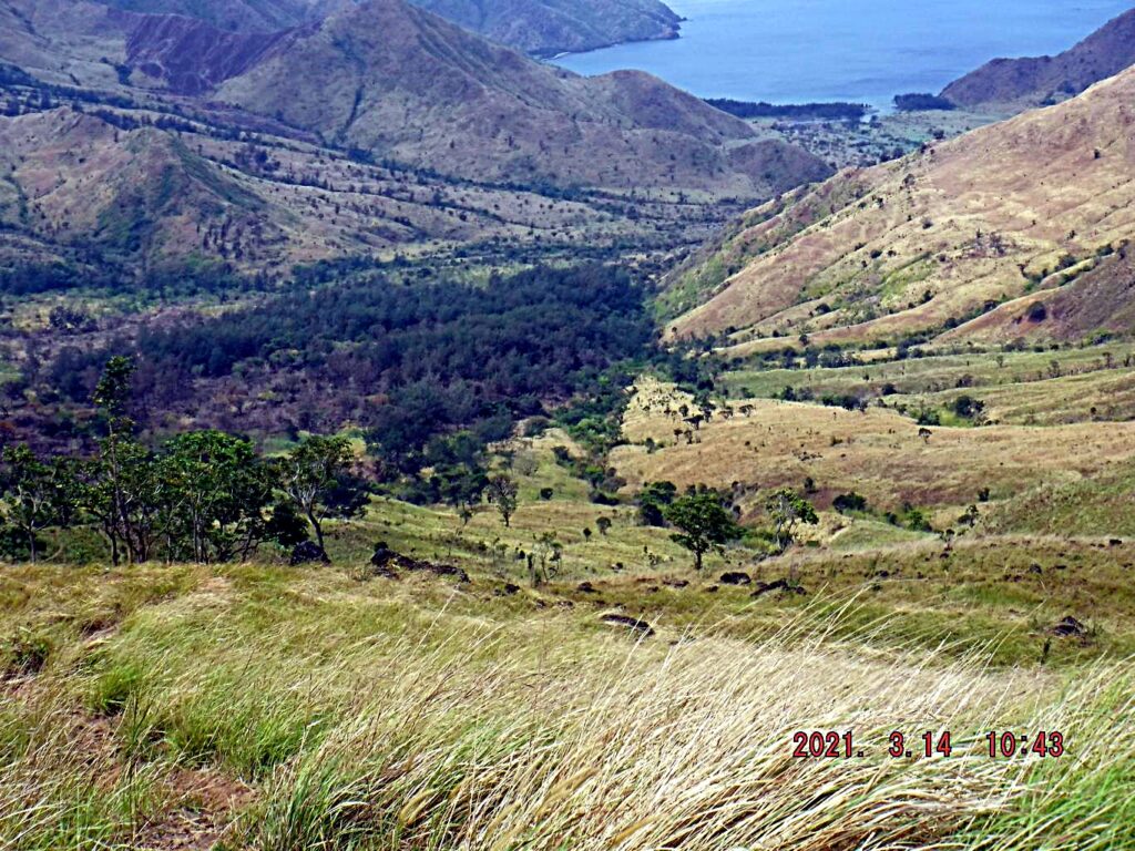 Zd971. Nazasa Bay viewed from the Nazasa Ridge, north crossing point. I walked up here in 2 hours and 50 minutes. I’m a slow walker, stop often to take pictures; also I stop often when going up a hill to slow down my heart beat and breathing rate. The trail is in perfect condition but today I turned around because that was all I wanted to do today. I want to walk it soon all the way to the bay, which should take another two hours to go down. Then, I either take a boat to Pundaquit or stay overnight and walk back. Anyone would like to join me? I walked to the Nazasa Bay several times in the past, using either this crossing or the south one. This valley was used as a bombing range and strafing range by the US Navy in 1945 and maybe later. A friend and I came across vehicles in this bay valley that were used as targets. 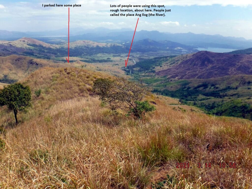 Zd972. The Cawag and Cayuag River Valley viewed from near the Nazasa Ridge Trail crossing. You should be able to identify the north end of the bay of Subic Bay. 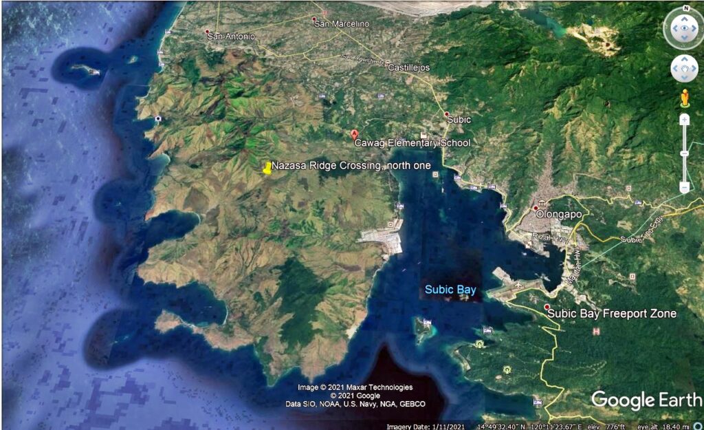 Zd973. A Google Earth image is provided for your orientation of the Subic Bay area with the location the Nazasa Ridge North Crossing indicated. |
|
|
|
Post by Karl Welteke on Mar 15, 2021 11:35:19 GMT 8
SBMA welcomes a probe into the Grande Island deal The Subic Bay Metropolitan Authority (SBMA) welcomes a probe into the Grande Island Investment Deal. The subicnewslink.blog reported this with this URL: subicnewslink.blogspot.com/2021/01/sbma-welcomes-probe-on-grande-island.htmlThese two pictures were attached to the above URL link 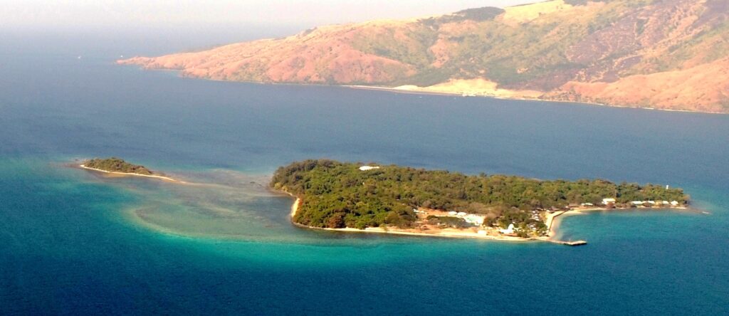 Zd974. Grande Island (the former Fort Wint) and Chiquita Island. Photo credit, it is from the above URL link. 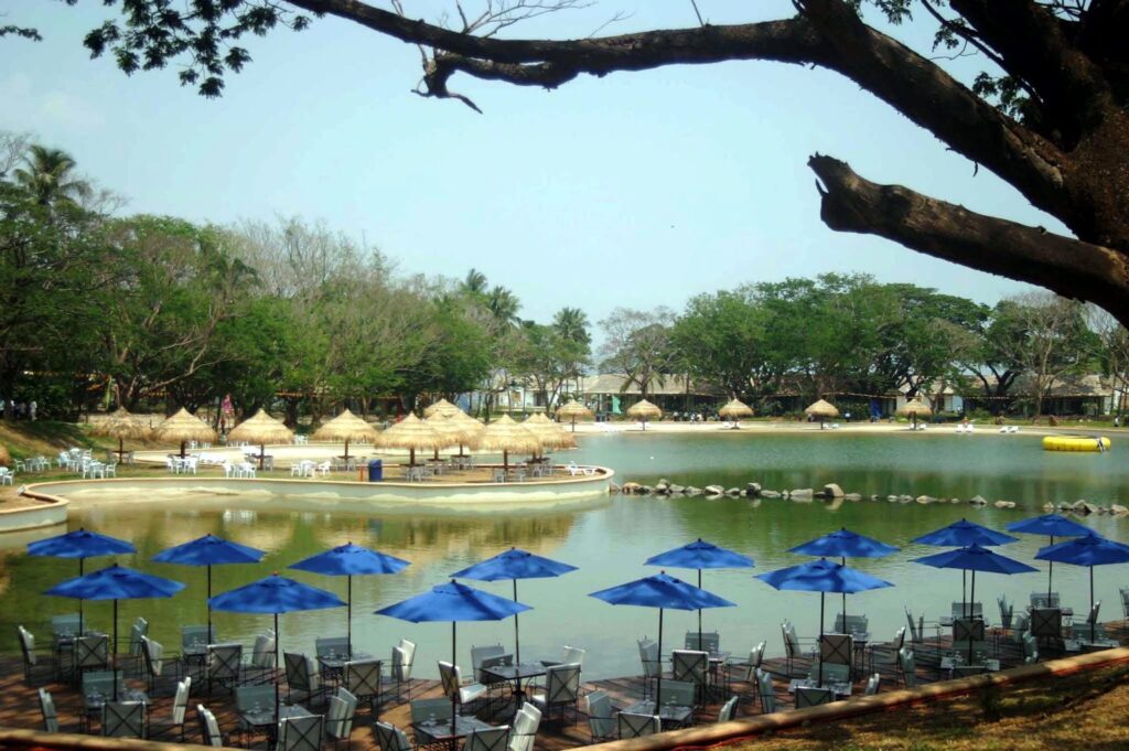 Zd975. The pool area of the Grande Island investment deal. Photo credit, it is from the above URL link. This is an old picture, today; in 2021 it does not look like this anymore. During the Navy time this was a ball field. 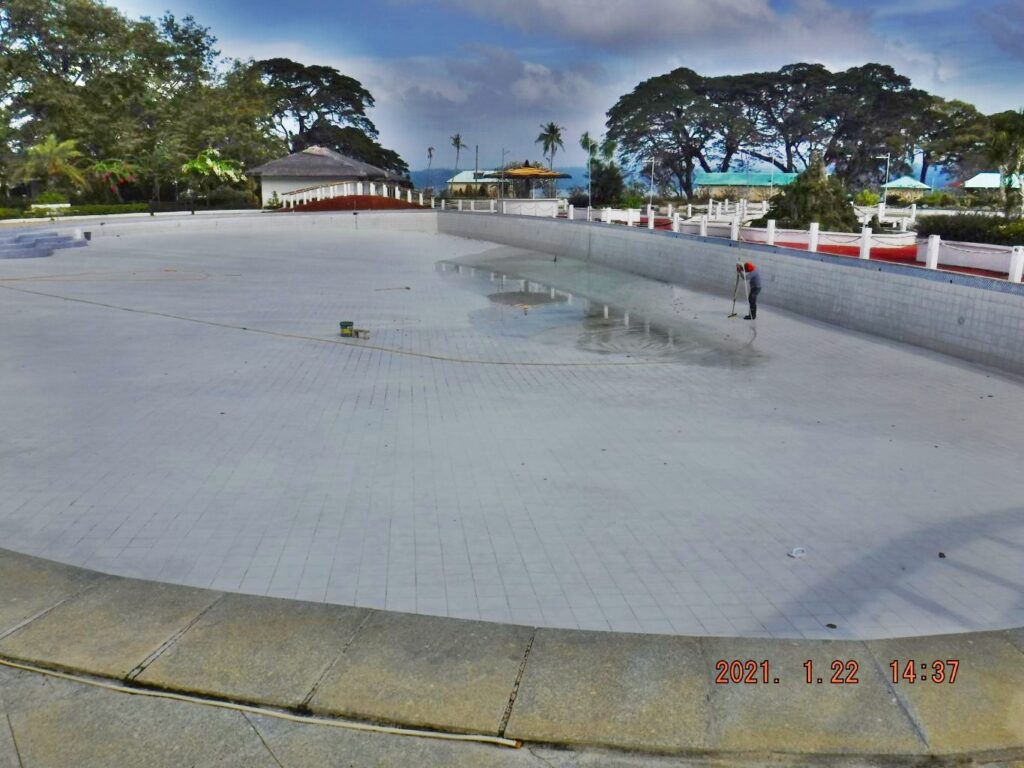 Zd976. This is the big pool in the Grande Island Resort, during my visit in January this year it was empty and was being cleaned. During the Navy time this was a ball field. 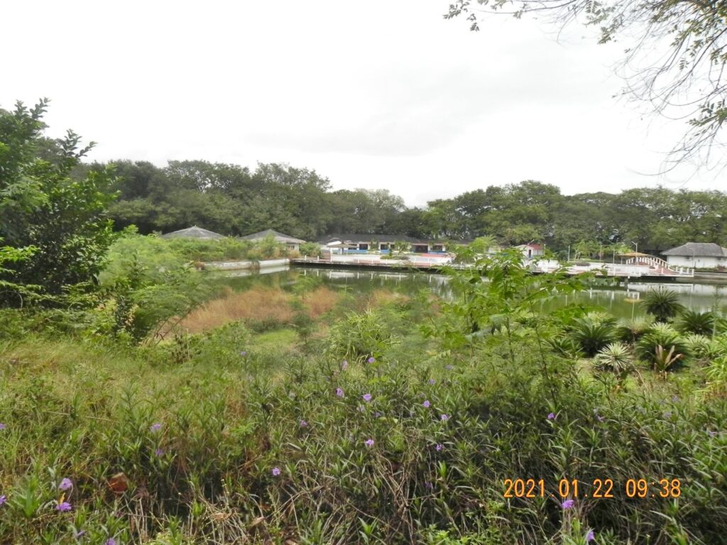 Zd977. This is a shot of the Grande Island Resort recreation area, shot from the area of the former Navy hotel and restaurant. The direction of this shot is similar as the image Zd975 but is from a farther distance. During the Navy time this was a ball field. If you like to know more about Grande Island and Fort Wint, check out these pages: URLs FOR FORT WINT AND GRANDE ISLAND IN CORREGIDOR.ORG AND IT’s FORUM A list of URLs in our forum that deal with Fort Wint in Subic Bay and Grande Island where Fort Wint was located, Fort Casey in WA is added: Ex FORT. WINT, GRANDE ISLAND SOURCES ON CORREGIDOR FORUM This is not the only URL or page that deals with this island or the fort. This is what is available in this forum or the web pages: -This is the history page about Fort Wint in the Corregidor.org web pages: corregidor.org/chs_bogart/bogart1.htm-This is a shorter history page about Wint in the Corregidor.org web pages: corregidor.org/chs_munson/wint.htm-This is the earliest visit to Grande Island after the Naval Base Closer, it was not open to the public but in 2003 an enterprise won the right to develop Grande Island. In 2004 some of us got a preview as to what was to see. corregidor.proboards.com/thread/113/pictures-grande-island-fort-wint-This is the 2nd visit to Grande Island in Sep 2004: corregidor.proboards.com/thread/111/follow-visit-grande-island-2004-The 3rd visit to Grande Island at 2006 with CDSG; corregidor.proboards.com/thread/114/visit-grande-island-2006-cdsg-This is the most comprehensive coverage we have in the forum about the island and the fort; much is about the Army on the island, building and running the fort. corregidor.proboards.com/thread/987/fort-wint-subic-bay-Was a 3” gun at Battery Flake (Fort Wint) spiked? corregidor.proboards.com/thread/1845/battery-flake-fort-wint-spiked-This URL touches on a possible CIA connection to Grande Island in the early 1950. corregidor.proboards.com/thread/1171/grande-island-The Philippine Red Cross President has Grande Island on his mind as a quarantine station for people infected with Ebola . corregidor.proboards.com/thread/1712/corregidor-grande-island-ebola-quarantine?page=1-I have actually 13 Fort Wint/Grande Island albums established in my Photobucket image sharing account; here is the URL with the 13 albums: app.photobucket.com/u/PI-Sailor/a/eeaa19d8-e98b-44e4-a464-395a72f66068-FORT WINT CONSTRUCTION ON GRANDE ISLAND IN SUBIC BAY These images show various batteries etc in Fort Wint on Grande Island in various stages of construction. The pictures were shot mostly from 1908 to 1910. These images were given to me by Karl Schmidt from the Coastal Defense Study Group (CDSG.org) who got the images from the National Archives and Records Administration (NARA). www.flickr.com/photos/44567569@N00/albums/72157664071460320-Fort Casey was visited by Randy Anderson in 2019, in the forum: corregidor.proboards.com/thread/2209/fort-wint-guns-casey-Fort Casey pictures from Randy Anderson of 2019 in his Flickr album: www.flickr.com/photos/39180497@N05/sets/72157708768194876/-Here is a group of Web Pages Karl has started about Fort Wint: philippine-sailor.net/category/manilabay/grandeisland/-Karl visited Grande Island on the 22nd of Jan. 2021 to get an update and established this forum page: URLs FOR FORT WINT AND GRANDE ISLAND IN CORREGIDOR.ORG AND IT’s FORUM A list of URLs in our forum that deal with Fort Wint in Subic Bay and Grande Island where Fort Wint was located, Fort Casey in WA is added: Ex FORT. WINT, GRANDE ISLAND SOURCES ON CORREGIDOR FORUM This is not the only URL or page that deals with this island or the fort. This is what is available in this forum or the web pages: -This is the history page about Fort Wint in the Corregidor.org web pages: corregidor.org/chs_bogart/bogart1.htm-This is a shorter history page about Wint in the Corregidor.org web pages: corregidor.org/chs_munson/wint.htm-This is the earliest visit to Grande Island after the Naval Base Closer, it was not open to the public but in 2003 an enterprise won the right to develop Grande Island. In 2004 some of us got a preview as to what was to see. corregidor.proboards.com/thread/113/pictures-grande-island-fort-wint-This is the 2nd visit to Grande Island in Sep 2004: corregidor.proboards.com/thread/111/follow-visit-grande-island-2004-The 3rd visit to Grande Island at 2006 with CDSG; corregidor.proboards.com/thread/114/visit-grande-island-2006-cdsg-This is the most comprehensive coverage we have in the forum about the island and the fort; much is about the Army on the island, building and running the fort. corregidor.proboards.com/thread/987/fort-wint-subic-bay-Was a 3” gun at Battery Flake (Fort Wint) spiked? corregidor.proboards.com/thread/1845/battery-flake-fort-wint-spiked-This URL touches on a possible CIA connection to Grande Island in the early 1950. corregidor.proboards.com/thread/1171/grande-island-The Philippine Red Cross President has Grande Island on his mind as a quarantine station for people infected with Ebola . corregidor.proboards.com/thread/1712/corregidor-grande-island-ebola-quarantine?page=1-I have actually 13 Fort Wint/Grande Island albums established in my Photobucket image sharing account; here is the URL with the 13 albums: app.photobucket.com/u/PI-Sailor/a/eeaa19d8-e98b-44e4-a464-395a72f66068-FORT WINT CONSTRUCTION ON GRANDE ISLAND IN SUBIC BAY These images show various batteries etc in Fort Wint on Grande Island in various stages of construction. The pictures were shot mostly from 1908 to 1910. These images were given to me by Karl Schmidt from the Coastal Defense Study Group (CDSG.org) who got the images from the National Archives and Records Administration (NARA). www.flickr.com/photos/44567569@N00/albums/72157664071460320-Fort Casey was visited by Randy Anderson in 2019, in the forum: corregidor.proboards.com/thread/2209/fort-wint-guns-casey-Fort Casey pictures from Randy Anderson of 2019 in his Flickr album: www.flickr.com/photos/39180497@N05/sets/72157708768194876/-Here is a group of Web Pages Karl has started about Fort Wint: philippine-sailor.net/category/manilabay/grandeisland/-Karl visited Grande Island on the 22nd of Jan. 2021 to get an update and established this forum page: corregidor.proboards.com/thread/2309/fort-wint-grande-island-update |
|
|
|
Post by Karl Welteke on Mar 19, 2021 18:12:35 GMT 8
Subic Freeport Expressway (SFEX) The 8.2-kilometer expansion project for the Subic Freeport Expressway (SFEX) was formally opened on Friday, Feb. 19. 2021. The day I returned from Corregidor the expansion was inaugurated and I noticed it as I drove bye. The story and the 2 pictures are from this subicnewslink.blogspot web page: subicnewslink.blogspot.com/2021/02/new-subic-freeport-expressway-now-open.htmlThe 8.2-kilometer expansion project for the Subic Freeport Expressway (SFEX) that was designed to provide better, faster and safer access to the Subic Bay Freeport Zone was formally opened on Friday, Feb. 19, by the project developer and high-ranking government officials. The project, which began in July 2019, was inaugurated by Executive Secretary Salvador Medialdea, Public Works Secretary Mark Villar, Transportation Secretary Arthur Tugade, Presidential Spokesperson Harry Roque, Subic Bay Metropolitan Authority (SBMA) Chairman and Administrator Wilma Eisma, Metro Pacific Investment Corporation (MPIC) President Jose Ma. Lim, Metro Pacific Tollways Corporation (MPTC) President Rodrigo Franco, and NLEX Corp President J. Luigi Bautista. Bataan 2nd District Representative Joet Garcia, Hermosa, Bataan Mayor Jopet Inton, and MPTC spokesperson Romulo Quimbo Jr. were also present in the occasion. The expressway project, which was touted to further accelerate economic growth in the Subic Bay Freeport and surrounding communities, was built at a cost of P1.6 billion. Chairman Eisma, who welcomed guests in the inauguration rites, acknowledged the heavy support of the national government in Subic’s development as a premier investment and tourism center and said that the project is another testament of President Duterte’s “strong support and love for the Subic Bay Freeport Zone.” Eisma thanked Medialdea and the other top officials in the Duterte Cabinet for further pushing development here. She also requested support for a proposed interchange that will benefit three industrial parks at the Tipo area, pointing out that these industrial projects signal the continued trust of foreign investors in the Philippines under the Duterte administration. The SFEX capacity expansion project entailed the construction of two additional expressway lanes, two new bridges at Jadjad and Argonaut Road, and a new two-pane tunnel. NLEX Corporation President Bautista said this will increase road capacity from one lane in each direction to two lanes in each direction, and thus will accelerate business activities and facilitate the flow of goods and services in and out of Subic. “One of the key drivers of economic growth is a network of high-quality roads. The NLEX Corporation through NLEX, SCTEX, and the soon-to-be expanded SFEX not only intends to accelerate development, but also hopes to encourage travel convenience and road safety,” Bautista added. Meanwhile, Presidential Spokesperson Harry Roque described the SFEX expansion as one of the key projects under President Duterte’s Build-Build-Build program and a testament that, under the Duterte Administration, the government is working non-stop to provide essential services to the people. Thanking the MPTC for initiating the project, Roque said the SFEX expansion has significantly hastened travel from Manila to the Subic Freeport and provided motorists an alternative and faster route in and out of the Subic Bay Freeport Zone. The SFEX, which is also known as the Subic-Tipo Expressway or NLEX Segment 7, connects the Subic Bay Freeport to the 94-kilometer Subic-Clark-Tarlac Expressway (SCTEx), which in turn links with the Tarlac-Pangasinan-La Union Expressway. (MPD-SBMA) PHOTOS:  U811. [1] An NLEX Corporation bus breaks the ceremonial ribbon during the formal opening of the newly completed 8.2-km Subic Freeport Expressway (SFEX) on Friday, Feb. 19.  U812. [2] Top-ranking government officials led by Executive Secretary Salvador Medialdea, Public Works Secretary Mark Villar, Transportation Secretary Arthur Tugade, Presidential Spokesperson Harry Roque, and SBMA Chairman Wilma Eisma headlined the opening of the newly completed 8.2-km Subic Freeport Expressway (SFEX) on Friday, Feb. 19. |
|
|
|
Post by Karl Welteke on Mar 24, 2021 19:06:48 GMT 8
2 Naval Station Olongapo images Found at the National Archive Files  U820. No. 1 pic. 2 Naval Station Olongapo images in WWII and or before, the pictures were provided by the Army Lt. Chester K. Britt Research Team. Read the team’s comment re the Oryoku Maru POW survivors when it was sunk in Dec. 1944 in Subic Bay. The people of the Army Lt. Chester K. Britt Research Team are: First is Dave Britt, LTC USAF (Ret), son of Chester K Britt, Vickie Graham CMSGT USAF (Ret), and John Duresky. They all graduated from Logan High School in La Crosse, Wisconsin in 1967, and are doing it as a team. Chester Britt graduated from Logan in 1933 and his mother Grace in 1934. Dave wrote most of the manuscript, John editing what he wrote and doing most of the research, and Vickie is the final editor with about 20 years of professional writing in her resume, largely with Airman Magazine. They are planning to write a book about Army Lt. Chester K. Britt soon!  U821. No. 2 pic. 2 Naval Station Olongapo images in WWII and before, the pictures were provided by the Army Lt. Chester K. Britt Research Team. Team member Duresky wrote this about this picture: Found the photo of the tip of Olongapo here catalog.archives.gov/id/80668972 Aftermath of all of the attacks by the USS Hornet and USS Cabot. Photo taken March 3, 1945, four days after the men reached Moji. Dock on shore is where Chester and Grace would have gotten off by shuttle from Fort Wint many times. Walkway to the right would have taken them to the Officer's Club at the naval base. Last is that wire photo I bought a few months ago. The people of the Army Lt. Chester K. Britt Research Team are: First is Dave Britt, LTC USAF (Ret), son of Chester K Britt, Vickie Graham CMSGT USAF (Ret), and John Duresky. They all graduated from Logan High School in La Crosse, Wisconsin in 1967, and are doing it as a team. Chester Britt graduated from Logan in 1933 and his mother Grace in 1934. Dave wrote most of the manuscript, John editing what he wrote and doing most of the research, and Vickie is the final editor with about 20 years of professional writing in her resume, largely with Airman Magazine. They are planning to write a book about Army Lt. Chester K. Britt soon! The two pictures are available in high resolution in the Flickr album: Uploaded to Flickr High Resolution Album No. 2: www.flickr.com/photos/44567569@N00/albums/72157715590015061 |
|


