|
|
Post by Karl Welteke on May 3, 2021 20:53:24 GMT 8
Scott Paul’s 2021-04 images of Subic Bay The present Subic Bay Hash House Harriers have been active here, almost for 30 years. A present very active member posts pictures every Month. The pictures show people, foreigners and locals doing their thing, their life styles and Subic Bay Scenery. This is the URL but the pictures don’t have descriptions: sway.office.com/JQJIJsuvM6sijTln?ref=LinkI took the liberty and chose 20 sample pictures, wrote descriptions and posted them in my Facebook page: The Subic Bay Hashing Group got started right after the Subic Bay Naval Base was turned over to the Philippines. Several of the original members are still around. If you want to know more about the Hashers in general, worldwide, Wikipedia has an article: en.wikipedia.org/wiki/Hash_House_HarriersThree (3) sample images are attached. .jpg?width=1920&height=1080&fit=bounds) U849. This is Subic Bay, Barrio Barretto; life goes on, in spite of the virus from Red China. In back is Grande Island, the former Fort Wint.  U950. Subic Bay Hash House Harriers (SBH3) on the trail; this is Barrio Barretto in front and Subic Bay.  U851. Subic Bay Hash House Harriers (SBH3) on the trail; this is Barrio Barretto, the job of widening the National Road is almost finished. |
|
|
|
Post by Karl Welteke on Jun 1, 2021 14:08:23 GMT 8
Two ex Roads to the Dizon Mine This is about geography in the greater Subic Bay area. I only attached 5 of the 9 images available in the 2 links below! But I left all 9 picture description in this presentation. The roads, tracks to the Dizon Mine from the in Subic Town and the Kalaklan Ridge road from Olongapo were once useable but are now grown over. Friends and I considered this a long and challenging trail and used it several times until about 10 years ago. A lot of people are surprised that this large gold and copper mine existed just over the hills behind Olongapo. The normal route of communication from and to the mine was via the Mapanuepe River Valley, thru the San Marcelino area and to the Dizon Port located at the end of Baloy Beach in Olongapo. The heavy rain in 1997 shut down the Dizon Mine, the open pit terraces collapsed and buried the open pit dewatering equipment, facilities. The mine was also severally affected by Mount Pinatubo in the early 1990s. The Marella River which comes from Mt. Pinatubo blocked the Mapanuepe River Valley exit and so a large lake formed. This new Mapanuepe Lake buried several communities in the Mapanuepe Valley, including Dizon Mine facilities. The Dizon Mine operator built a new road on the south slopes of the Mapanuepe Valley which is still used today! Just this year I made it my goal to find the Dizon Pass again. I tried it 2 weeks ago and I failed. On the 25th of May 2021 I tried again, with new calculation based on the previous try, and succeeded. So, I’m happy that archived it, it was challenging. I like to share this walk, hike. 9 pictures only have been uploaded to these two choices, take your pick: Uploaded to my Facebook Uploaded to Karl’s web page, Central Luzon, Zambales #1: philippine-sailor.net/2021/06/01/two-ex-roads-to-the-dizon-mine/Zf164. The Rocky, Monolith Peak or Peaks of Mount Balakibok. This peak or these peaks are prominent visible from just about anywhere in Olongapo. The Kalaklan Ridge leads to the peaks and a road and power lines to the Dizon Mine run along the ridge. The power lines are gone now and the road is now impassible at the upper end. My friend Carlito Pickering said, when he was stationed here in the 1980s he drove along this road, passed the peak to its left and then descended to the Dizon Mine Pass about 1 km or so. I walked this trail to about 10 years ago and 5 years ago when I tried it again I lost the trail, it was completely overgrown. 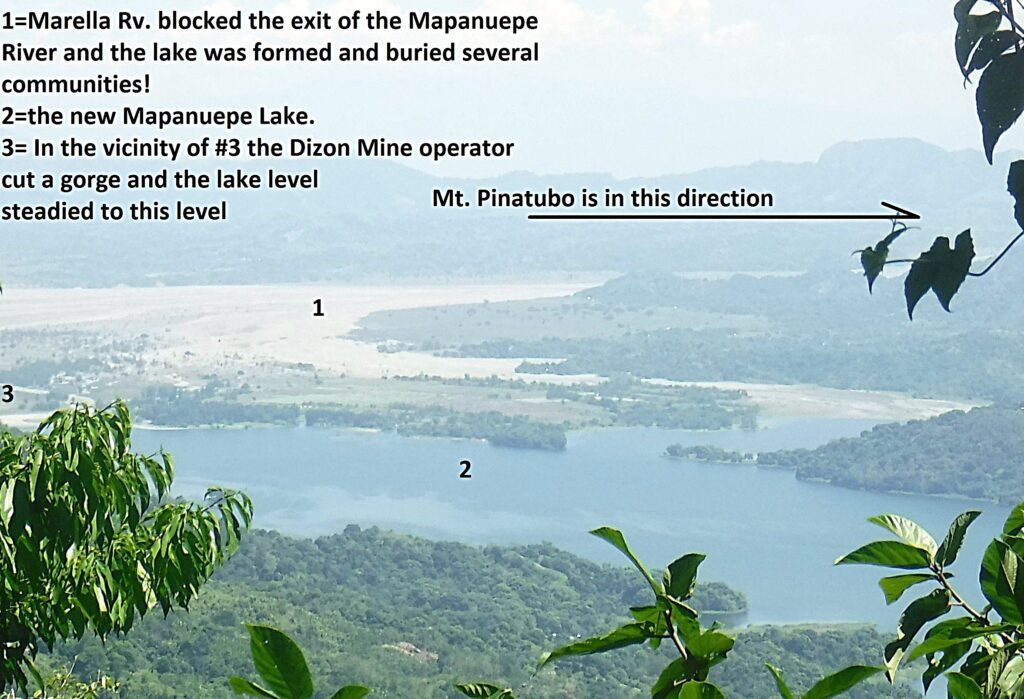 Zf165. After I reached the pass, I followed a trail up the ridge to the left and followed the road down to the Dizon Mine but it was so grown over that I could not go further without a bolo or machete. Only once was I able to get a glance of the Dizon Mine, Mapanuepe Lake and the Marella River Mt. Pinatubo Lahar area, this is one of those shots. 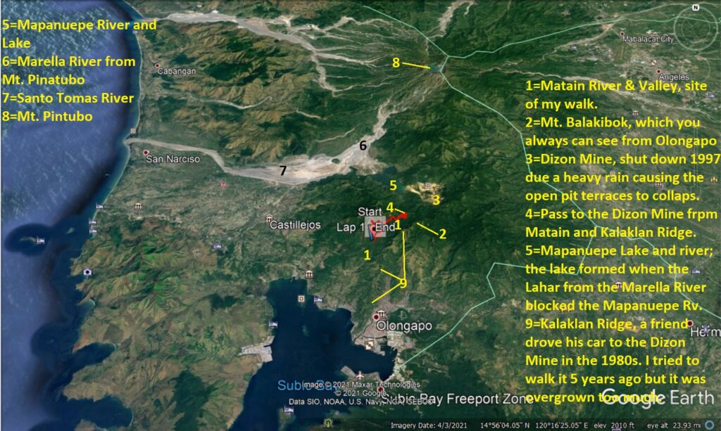 Zf166. This Google Earth image gives the big picture how my walk and views relate to the bigger geographic area. I think pictures without subscriptions are not very interesting most of the time. 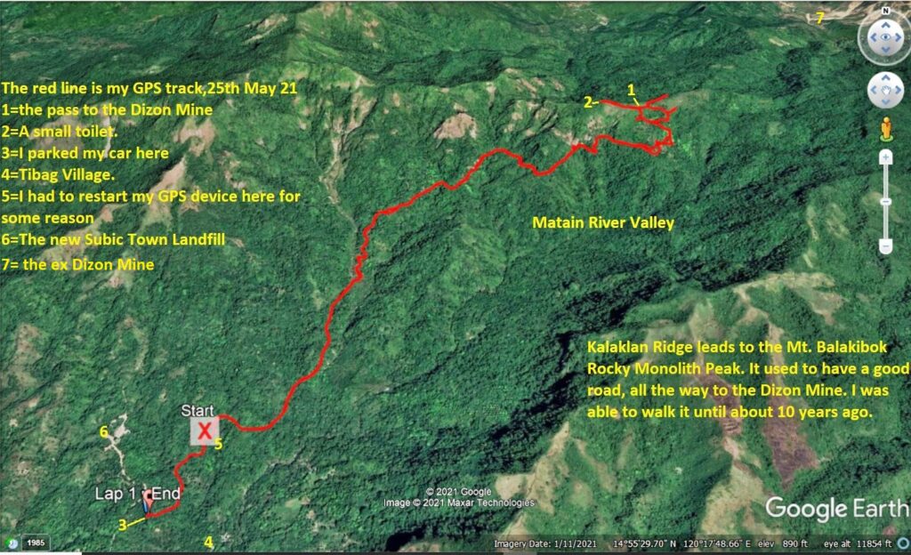 Zf167. My track in the Matain River Valley to the Dizon Mine Pass zoomed in. In the valley the trail was a pretty good trail, easy to follow. But near my goal the tracks became many and were confusing. There was much animal activity (tracks or disturbed soil, grounds) on top, under the pass but on this side only. And the former road had completely disappeared. About 1994 the Dizon Family built a new road at along the track I walked today. They wanted an alternat5e road to their mine. But the Benguet Corporation never used it and it is pretty much grown over now. 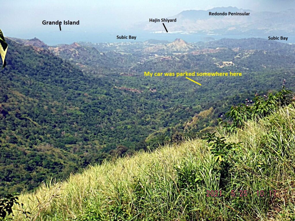 Zf168. A view down-river the Matain River Valley and we have the grand Subic Bay Vista. On this side, several times, did I have this view or the Kalaklan Ridge across the valley. Zf169. This is the actual Dizon Mine Pass, looking toward the mine direction. The Dizon Mine road veers immediately to the right and runs down just parallel under the ridge line, on the Dizon Mine side. 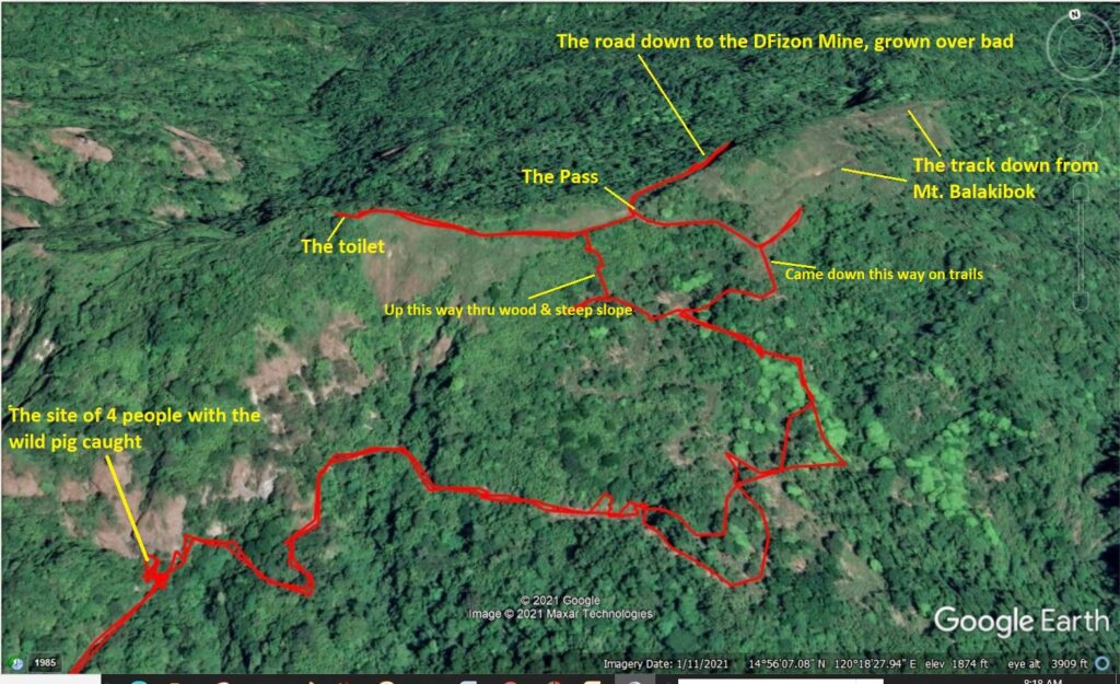 Zf170. This is the Dizon Mine Pass area zoomed in. I remembered a road that went up the ridge to the left and that was the trail I first came across and I followed it up. It did have an end and there was a small toilet. I assume it was used as a lookout point during the 1990s Lahar Crisis. In this picture, I share with you, is where I came across a party of 4 men who just killed a wild female big that was caught in a trap set the day before. On my way back they had it roasted. I asked them whether I could take a picture and they said no! The old road that connected to the pass, I did not find anymore and so I decided I got to go straight up, wherever I could go thru and hang on to trees or scrub. Well, I did come across the old road, now a trail to the lookout and toilet station. From that point it was easy just follow the trail and that is how I came down and meet up with my track coming up. Zf171. Here is the toilet station, the throne lying outside, though. I assume it was used in the early 90s as an observation point to watch for the Mt. Pinatubo Lahar rushing down the Marella River. Zf172. Total elevation gain for this walk, hike was 527 meter, not bad for this 79 year young stud and it is hot here, especially this month! |
|
|
|
Post by Karl Welteke on Jun 17, 2021 16:02:28 GMT 8
March-May 2021 Subic Bay Random Shots Although we still suffer under the rules of the Virus from Red China Pandemic, we are able to walk around. Many small businesses are open and everybody follows the antivirus protocol, masks, shields, register etc. I walk a lot and sometime I take a picture that tells a story about Subic Bay. I posted 55 pictures in this Flickr album in high resolution, each picture has a description: www.flickr.com/photos/44567569@N00/albums/72157719403065131/with/51242577624/For this forum presentation, I chose these 3 images; they have descriptions but are in a smaller size!  U864. 210303 Barretto, By the Sea Hotel and the Central Park Reef Hotel are open now! Guests do arrive from maybe as far as Manila.  U865. 210303 Barretto highway widening; this is the National Highway to Zambales, thru Barretto, it has been widened. And often the traffic is heavy and fast, it is sometime dangerous to cross the highway. Behind the yellow building is the Del Pilar Street to the former Marmont Hotel. I can state that I saw or see massive infrastructure work all the time, lots of concreting, widening of roads and bridges.  U866. 210521 Barretto Beach, south winds returned a; the rainy season is about to start and it did start, exactly on schedule on the 1st of June 2021. This is a view of Barretto Beach. |
|
|
|
Post by Karl Welteke on Oct 2, 2021 16:57:32 GMT 8
Hanjin Shipyard North Wall trip. 31 Aug. 2021. I wanted to explore around the Hanjin Shipyard, closed now in bankrupt procedures. The place has guards but I detected no other activities! Parked at the bus parking, saw 2 buses there, touched base with the gate guards, and told them, I will walk along the wall outside. Found the trail that led to the old road to the wall and followed it to the end. Saw a horse and rider coming my way; saw 3 houses on the other end, inland end. Continued walking, Hanjin Wall had expanded since my last visit, many years ago but I could not find a good trail going to the south river and a way to the ridge with road cuts across the ridge to the next valley. So, I gave up and returned. Made a Facebook entry with 14 images if you are interested, click here for the URL: Two sample images: 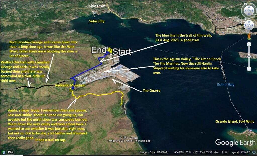 Zf306. 02 210831 Hanjin Shipyard North-Wall, Subic Bay, Google Earth big image. 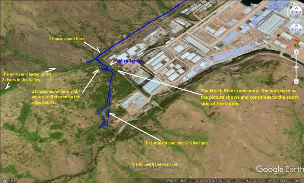 Zf307. 08 210831 Hanjin Shipyard North-Wall, west-end, Google-Earth image. |
|
|
|
Post by Karl Welteke on Dec 5, 2021 19:07:11 GMT 8
A new Bridge over the Baquilan River 30. Oct. 2021 This bridge is part of the new Botolan to Capas Road being build, however so slowly. This day, 30th Oct. 2021, several families and mine decided to make a picnic trip to Camp Kainomayan Resort. This camp is located where the Bucao River Dike starts near the Baquilan Resettlement Village. This is my WALKING AREA, I have been here many times. So, I took advantage of this family trip and explored the Baquilan River mouth to see whether there is any progress in the construction of the Botolan-Capas Road. Well, a new bridge is being constructed! Some 90 images of this exploration trip where uploaded with high resolution into this Flickr album, click here: www.flickr.com/photos/44567569@N00/albums/72157720204111213Here are some sample images: 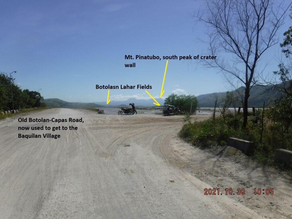 Zf383. One of 7 images of the Bucao River, where the Bucao River Dike hits the Bucao River reinforced embankment under the Baquilan Resettlement Village. We have views of the Bucao River, the Balin-Buguero River, Mt. Pinatubo and the unique irrigation intake, buried by the Mt. Pinatubo Lahars, but it still works great. We also see a recent irrigation improvement project. 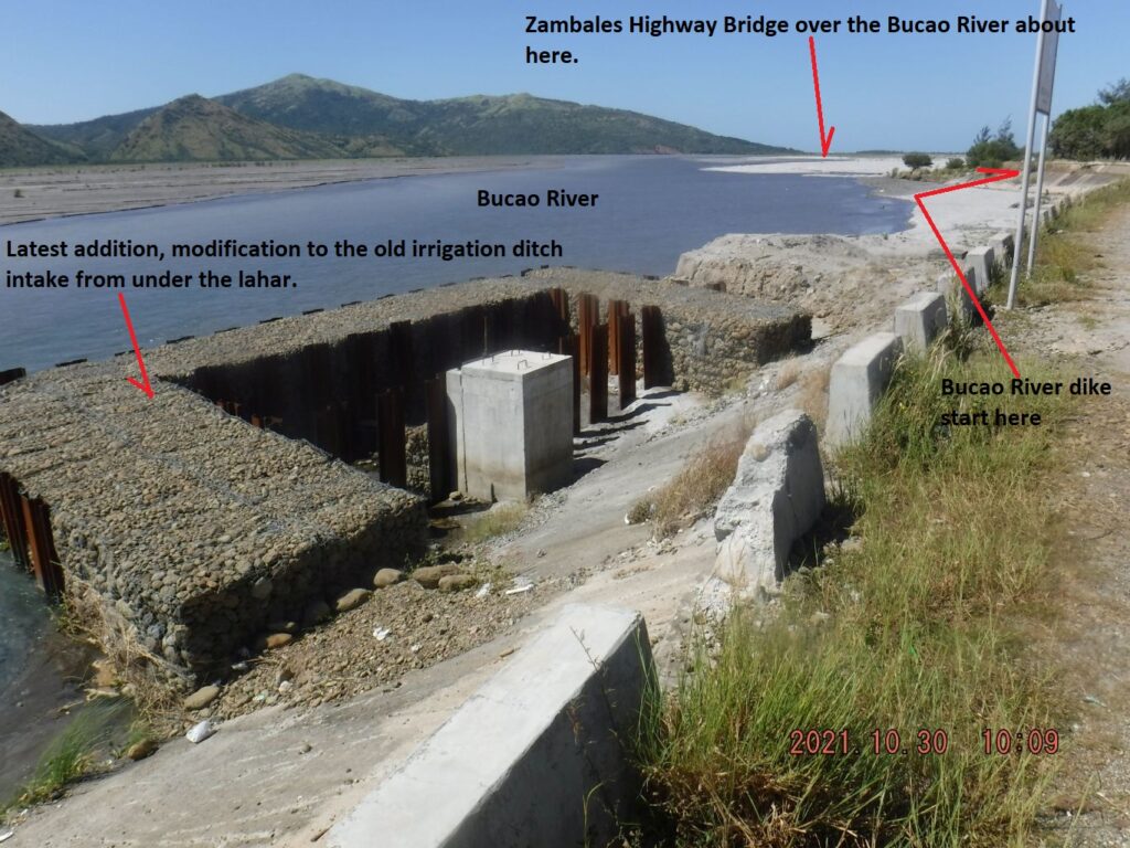 Zf384. One of 7 images of the Bucao River, where the Bucao River Dike hits the Bucao River reinforced embankment under the Baquilan Resettlement Village. We have views of the Bucao River, the Balin-Buguero River, Mt. Pinatubo and the unique irrigation intake, buried by the Mt. Pinatubo Lahars, but it still works great. We also see a recent irrigation improvement project. 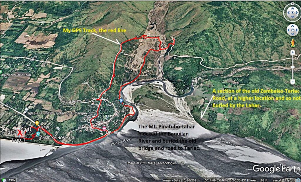 Zf385. One of 8 map or data images of the area of the Baquilan River Mouth. It shows roads that are being used now and roads to be used when the Zambales-Tarlac Road is finished. The maps also show my GPS track. The pictures show the Baquilan Resettlement village, the irrigation intakes and the irrigation ditch, the embankment reinforcement at the foot of the Baquilan Village location. The maps show the water flows of the Bucao and Baquilan Rivers. We also see the location of the Bucao River Dike and Camp Kainomayan. This is my GPS track of the 30th Oct. 2021! 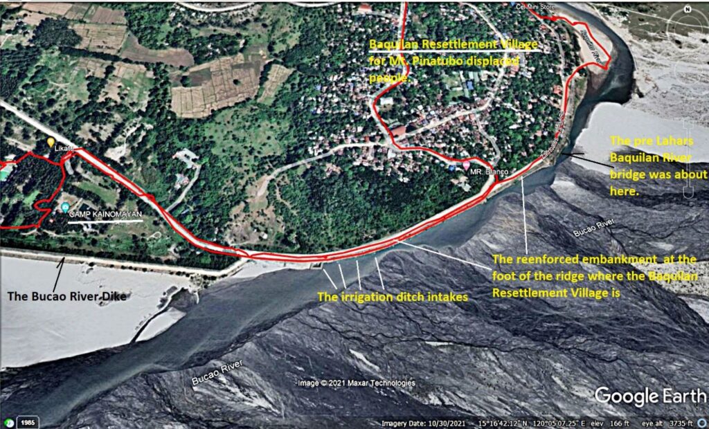 Zf386. One of 8 map or data images of the area of the Baquilan River Mouth. It shows roads that are being used now and roads to be used when the Zambales-Tarlac Road is finished. The maps also show my GPS track. The pictures show the Baquilan Resettlement village, the irrigation intakes and the irrigation ditch, the embankment reinforcement at the foot of the Baquilan Village location. The maps show the water flows of the Bucao and Baquilan Rivers. We also see the location of the Bucao River Dike and Camp Kainomayan. 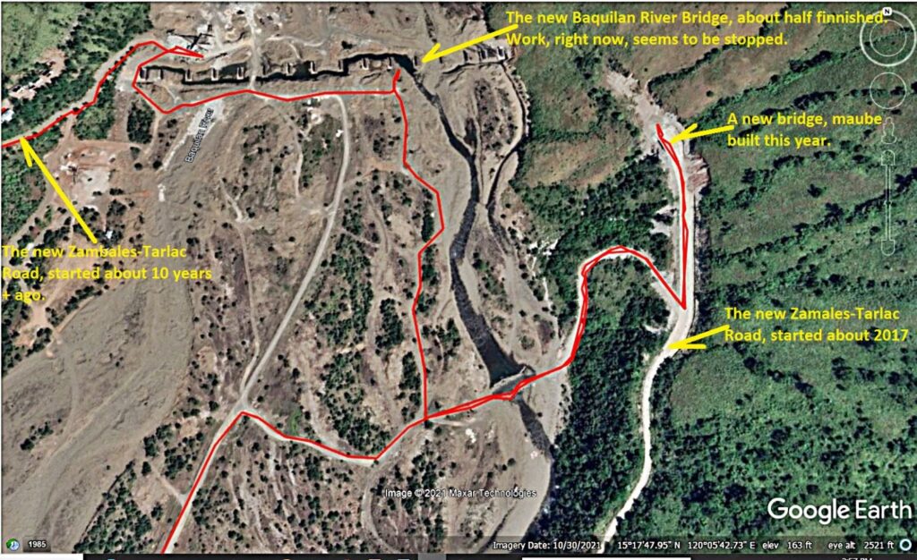 Zf387. One of 8 map or data images of the area of the Baquilan River Mouth. It shows roads that are being used now and roads to be used when the Zambales-Tarlac Road is finished. The maps also show my GPS track. The pictures show the Baquilan Resettlement village, the irrigation intakes and the irrigation ditch, the embankment reinforcement at the foot of the Baquilan Village location. The maps show the water flows of the Bucao and Baquilan Rivers. We also see the location of the Bucao River Dike and Camp Kainomayan. This is my GPS track in the vicinity of the two bridges on the 30th Oct. 2021! 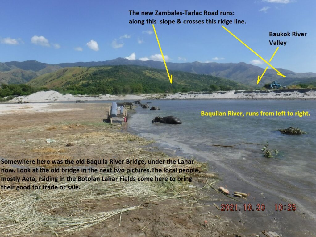 Zf388. One of 23 images of the Baquilan River Mouth area (including 2 pics from 2002), the first few pictures show the Bucao River embankment at the foot of the Baquilan Resettlement Village Ridge, under/down from the village. This is also the old Zambales to Tarlac Road, this is the area where the Bucao River Lahar blocked the Baquilan River and buried the old road and bridge. This is the place where the people from the Botolan Lahar Fields, the NW area from Mt Pinatubo, bring their material for sale or trading. The last pictures show us going upriver where vehicles cross to get to the new Botolan-Capas Road. 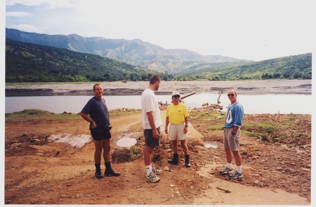 Zf389. One of 23 images of the Baquilan River Mouth area (including 2 pics from 2002), the first few pictures show the Bucao River embankment at the foot of the Baquilan Resettlement Village Ridge, under/down from the village. This is also the old Zambales to Tarlac Road, this is the area where the Bucao River Lahar blocked the Baquilan River and buried the old road and bridge. This is the place where the people from the Botolan Lahar Fields, the NW area from Mt Pinatubo, bring their material for sale or trading. The last pictures show us going upriver where vehicles cross to get to the new Botolan-Capas Road. This is a 2002 image from my friend Joss, this former Baquilan River Bridge is now deep under the Lahar. This is a 2002 image from my friend Joss, this former Baquilan River Bridge is now deep under the Lahar. 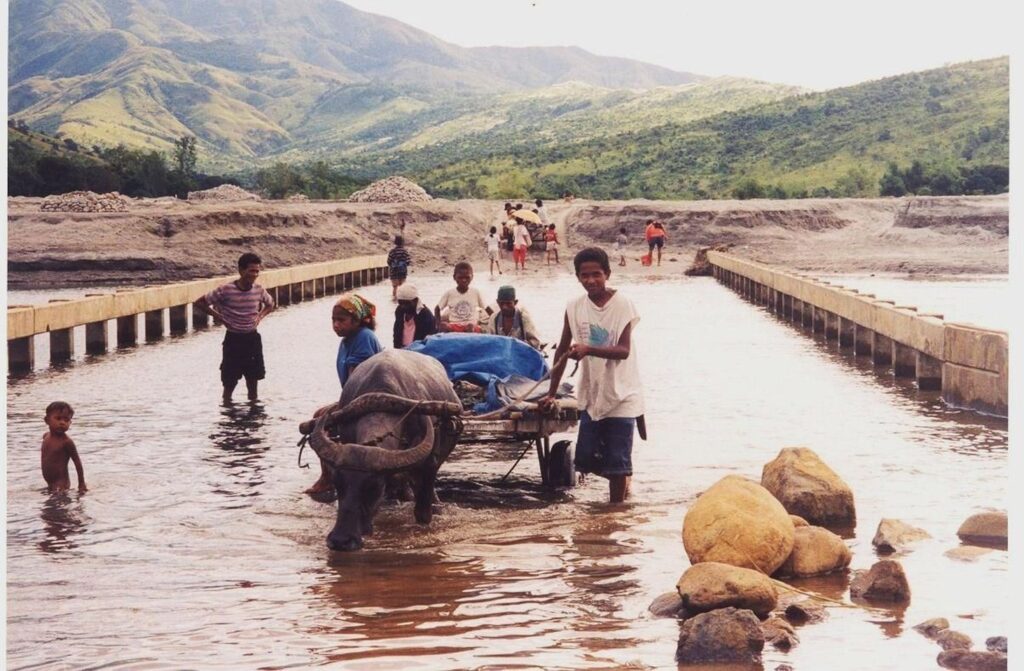 Zf390. One of 23 images of the Baquilan River Mouth area (including 2 pics from 2002), the first few pictures show the Bucao River embankment at the foot of the Baquilan Resettlement Village Ridge, under/down from the village. This is also the old Zambales to Tarlac Road, this is the area where the Bucao River Lahar blocked the Baquilan River and buried the old road and bridge. This is the place where the people from the Botolan Lahar Fields, the NW area from Mt Pinatubo, bring their material for sale or trading. The last pictures show us going upriver where vehicles cross to get to the new Botolan-Capas Road. This is a 2002 image from my friend Joss, this former Baquilan River Bridge is now deep under the Lahar. 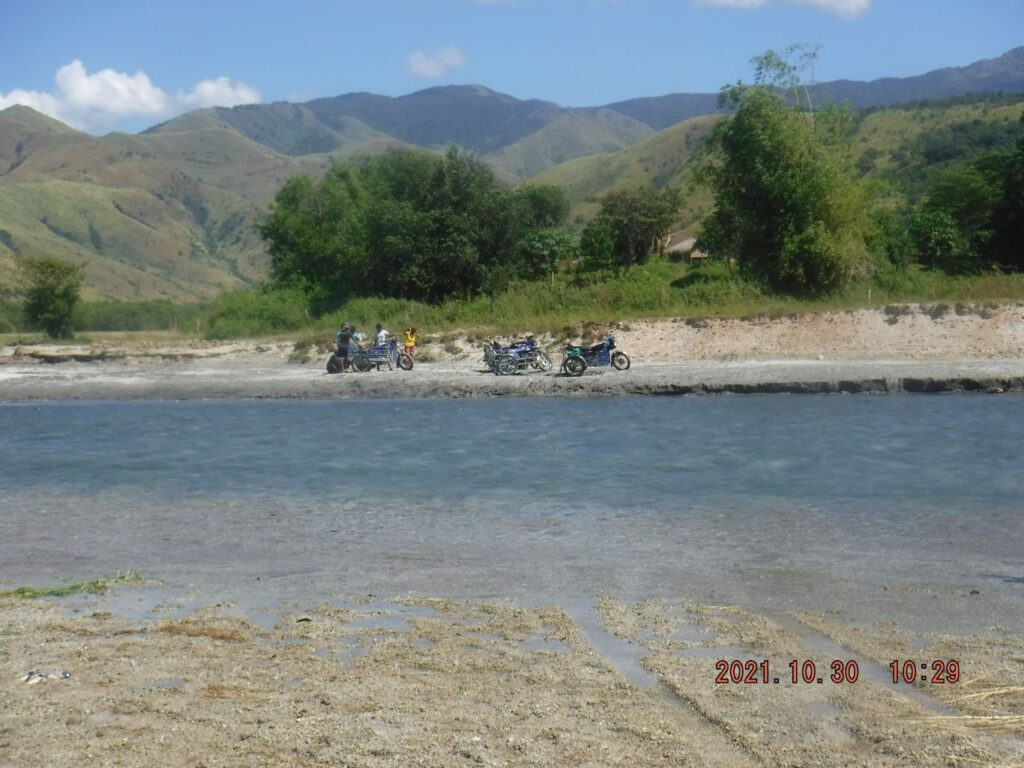 Zf391. One of 23 images of the Baquilan River Mouth area (including 2 pics from 2002), the first few pictures show the Bucao River embankment at the foot of the Baquilan Resettlement Village Ridge, under/down from the village. This is also the old Zambales to Tarlac Road, this is the area where the Bucao River Lahar blocked the Baquilan River and buried the old road and bridge. This is the place where the people from the Botolan Lahar Fields, the NW area from Mt Pinatubo, bring their material for sale or trading. The last pictures show us going upriver where vehicles cross to get to the new Botolan-Capas Road. This is a 2002 image from my friend Joss, this former Baquilan River Bridge is now deep under the Lahar. There was considerable motor bike traffic ON THE OTHER SIDE OF THE Baquilan River, maybe one day I catch a ride with them. 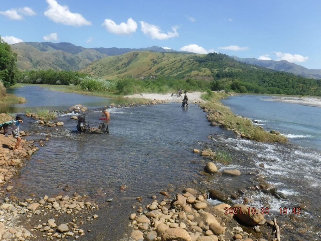 Zf392. One of 17 images of crossing the Baquilan River to get to starting point of the new Zambales-Tarlac Road that got started about 2017. I have walked that new road and reported about in our forum in this URL: corregidor.proboards.com/thread/1655/excursions-philippines?page=5I noticed considerable motorbike and tricycle traffic. Plus the river was used by many, mostly young people, for recreation. The new road is going into the Baukok River, which water is also draining into the Baquilan River. The last picture of this 17 image section is from that 2017 forum presentation. 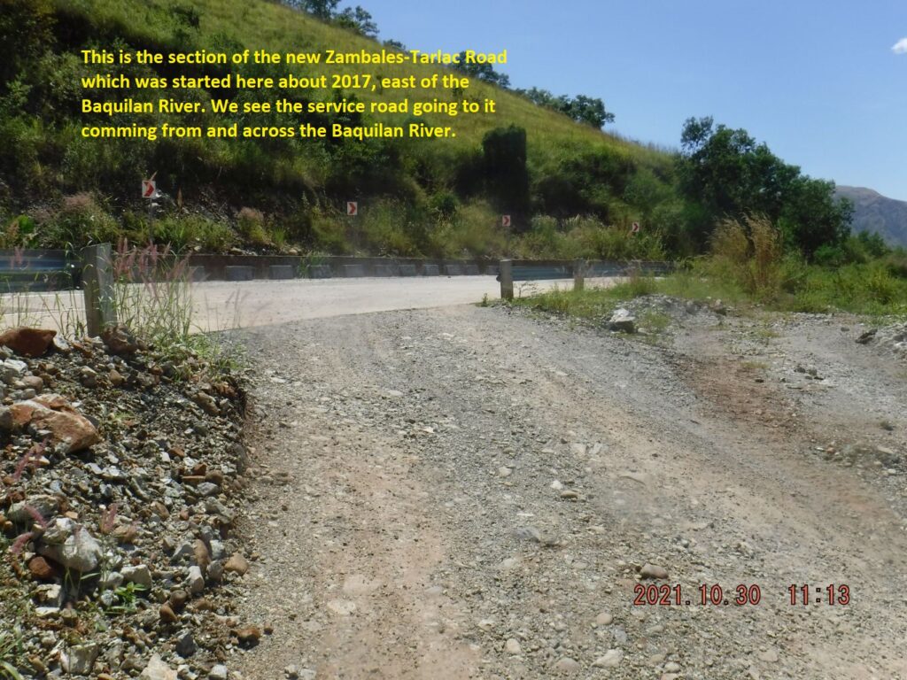 Zf393. One of 17 images of crossing the Baquilan River to get to starting point of the new Zambales-Tarlac Road that got started about 2017. I have walked that new road and reported about in our forum in this URL: corregidor.proboards.com/thread/1655/excursions-philippines?page=5I noticed considerable motorbike and tricycle traffic. Plus the river was used by many, mostly young people, for recreation. The new road is going into the Baukok River, which water is also draining into the Baquilan River. The last picture of this 17 image section is from that 2017 forum presentation. 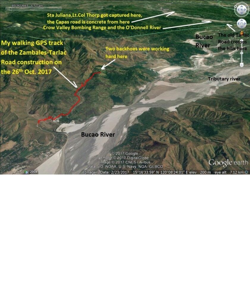 Zf394. One of 17 images of crossing the Baquilan River to get to starting point of the new Zambales-Tarlac Road that got started about 2017. I have walked that new road and reported about in our forum in this URL: corregidor.proboards.com/thread/1655/excursions-philippines?page=5I noticed considerable motorbike and tricycle traffic. Plus the river was used by many, mostly young people, for recreation. The new road is going into the Baukok River, which water is also draining into the Baquilan River. The last picture of this 17 image section is from that 2017 forum presentation. 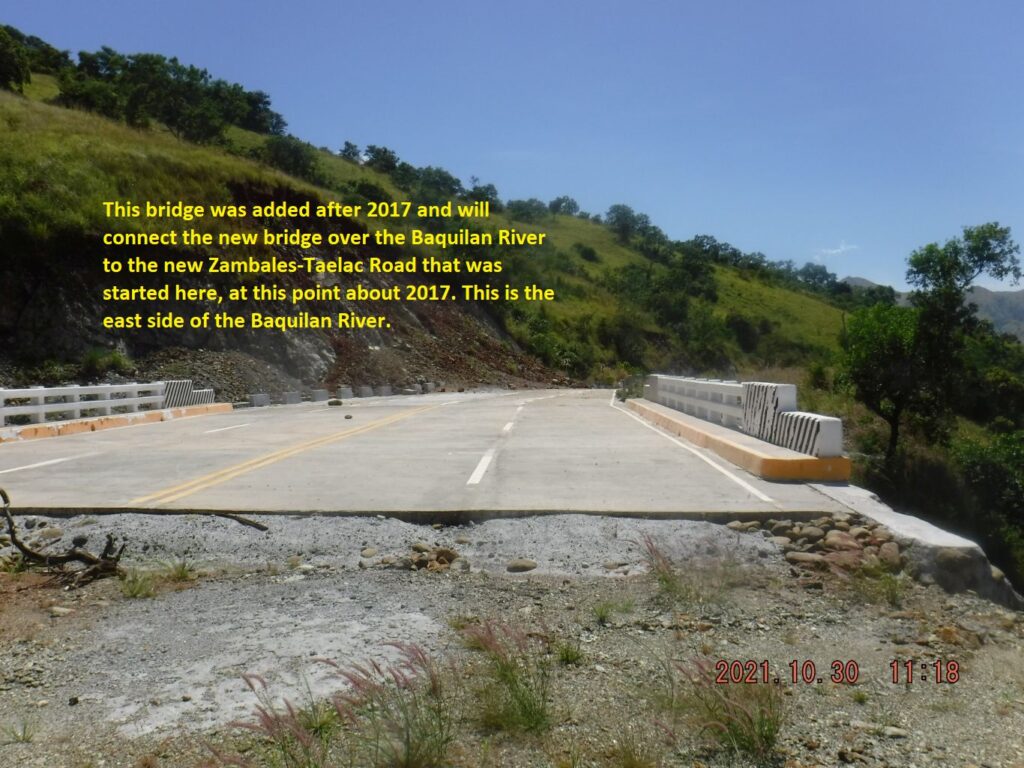 Zf395. One of 19 images of the area where two new bridges, cross the Baquilan River and connect the Zambales-Tarlac Road sections, west and east of the Baquilan River. The main river bridge is maybe 50 % finished but it seems work has stopped. A new bridge also was built on the east side of the Baquilan River to connect the river bridge with the new road on the east side. Here I crossed the Baquilan River again to return to my starting point. 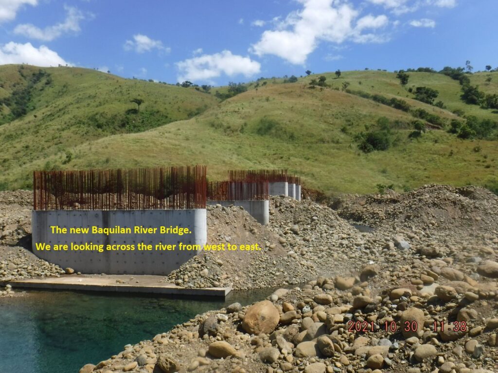 Zf396. One of 19 images of the area where two new bridges, cross the Baquilan River and connect the Zambales-Tarlac Road sections, west and east of the Baquilan River. The main river bridge is maybe 50 % finished but it seems work has stopped. A new bridge also was built on the east side of the Baquilan River to connect the river bridge with the new road on the east side. Here I crossed the Baquilan River again to return to my starting point. 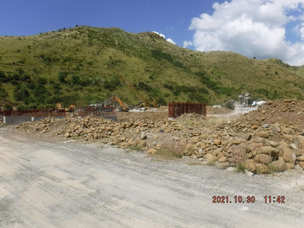 Zf397. One of 19 images of the area where two new bridges, cross the Baquilan River and connect the Zambales-Tarlac Road sections, west and east of the Baquilan River. The main river bridge is maybe 50 % finished but it seems work has stopped. A new bridge also was built on the east side of the Baquilan River to connect the river bridge with the new road on the east side. Here I crossed the Baquilan River again to return to my starting point. 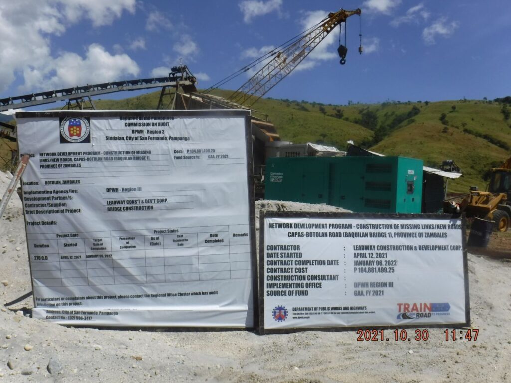 Zf398. One of 19 images of the area where two new bridges, cross the Baquilan River and connect the Zambales-Tarlac Road sections, west and east of the Baquilan River. The main river bridge is maybe 50 % finished but it seems work has stopped. A new bridge also was built on the east side of the Baquilan River to connect the river bridge with the new road on the east side. Here I crossed the Baquilan River again to return to my starting point. 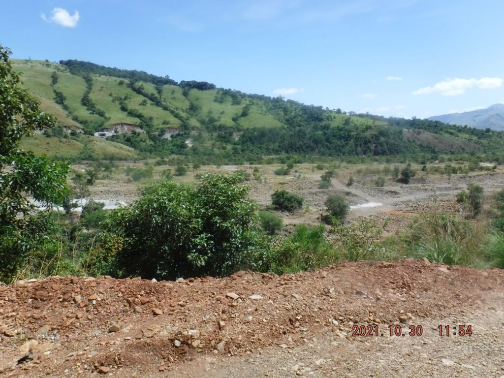 Zf399. One of 15 images of my walk from the new Baquilan Bridge, back to and down thru the Baquilan Resettlement Village. I enjoyed views of the new Baquilan River Bridge, the Baquilan River and Valley, the Baukok River Valley which the new Zambales-Tarlac Road goes into and leaves over a ridge. The mighty Bucao River came back into sight. In this picture we can see the new bridge on the east side of the Baquilan River. 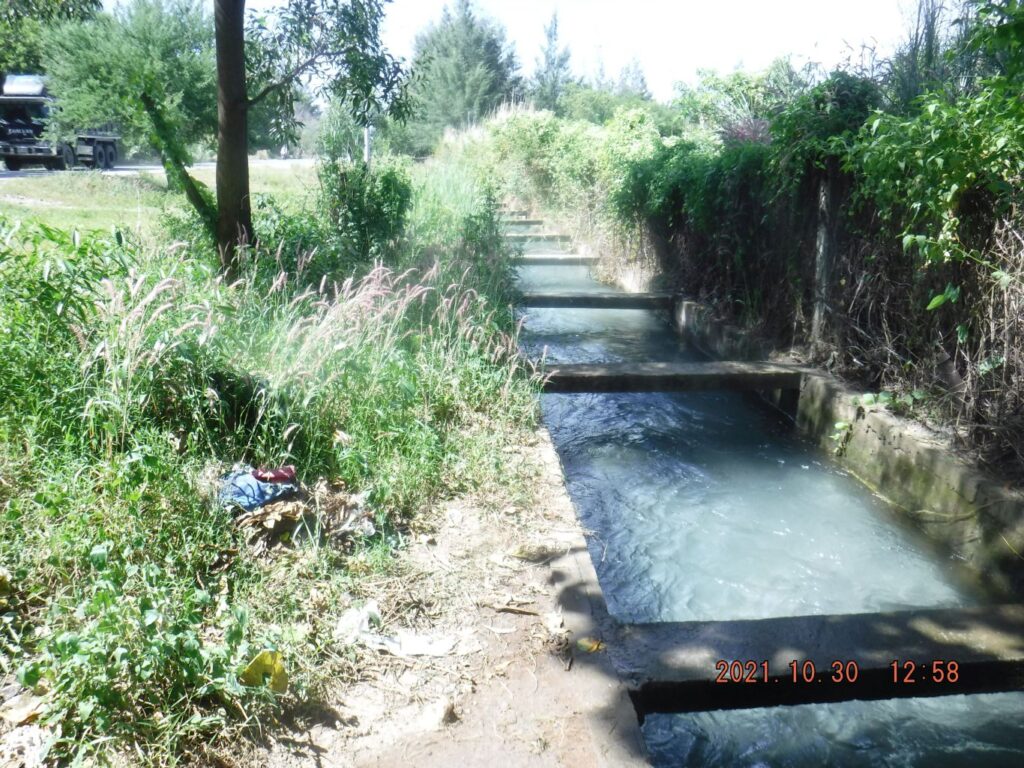 Zf400. One of 4 images of the Km Stone #202, which is 1 Km from Baquilan Village and 6 Km from Botolan, It is very close to the entrance of Camp Kainomayan. I find the irrigation system also very interesting it is taking in water from the Bucao River, runs under the Bucao River Lahar, under the Bucao River Dike, feeds some water into the stream in Camp Kainomayan and feeds an irrigation ditch with lots of water. 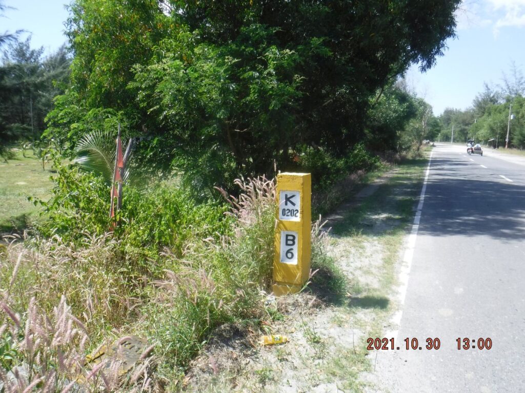 Zf401. One of 4 images of the Km Stone #202, which is 1 Km from Baquilan Village and 6 Km from Botolan, It is very close to the entrance of Camp Kainomayan. I find the irrigation system also very interesting it is taking in water from the Bucao River, runs under the Bucao River Lahar, under the Bucao River Dike, feeds some water into the stream in Camp Kainomayan and feeds an irrigation ditch with lots of water. |
|
|
|
Post by Karl Welteke on Jan 30, 2022 17:37:55 GMT 8
Barretto to Olongapo Short Walk 2022-01-29 Barretto to Olongapo over Kalaklan Ridge and back, Short Walk. Started from Abra Street, up the diagonal trail to the Barretto Ridge, crossed it and down to the houses by the Kale Beach Valley Waterfall, straight up to Kalaklan Ridge, crossed it and down to Upper Kalaklan, near the bridge to Olongapo Rotunda. Walked south and checked the new bridge for tricycles and motor bikes only. Then up a trail to Kalaklan Ridge starting behind the big Iglesia ni Christos Church. Checked out the new Magsaysay election sign on top. Walked up Kalaklan Ridge about 3 km and down the diagonal trail down the Rizal Extension Street and home. An album with 58 images of that walk was established in this Photobucket album, click here: app.photobucket.com/u/PI-Sailor/a/ca3607a7-a6ad-4f0d-ba04-e84e9f2116c7A shorter version with 12 images were posted in Facebook, click here: 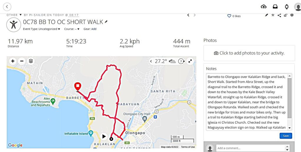 Zf525. (05b). From my Garmin account, track records! This is one of 7 images from my Garmin and Google Earth accounts that show my GPS track, elevation graph and my walking data etc, some are zoomed in. 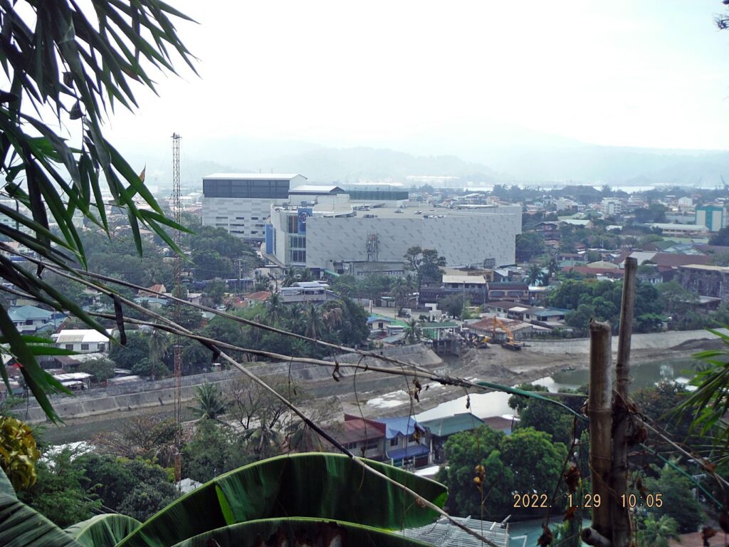 Zf526. (10). Our 3rd and new mall in Olongapo, the SM Central. It was build at the site of the old Olongapo Quonsets Huts Hospital! This is one of 9 images of Olongapo City views during my descend from on top of Kalaklan Ridge down to near the bridge that leads into Olongapo and the Rotunda. Some shots are views of Olongapo and one shows the rear of the Victory Liner Station, the new SM Central Mall and the area of Kalaklan Ridge where I will walk up again, behind that Iglesia ni Christo Church. 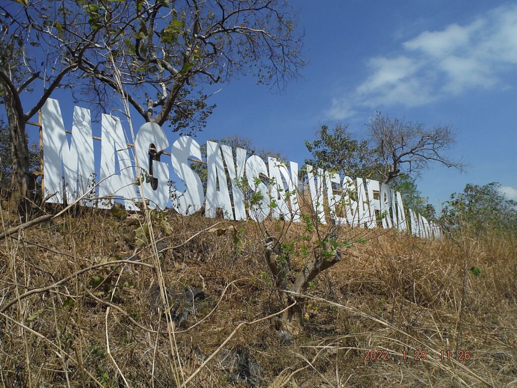 Zf5527. (34). This is one of 17 images of my climb/walk back up to Kalaklan Ridge to where the Magsaysay, and others, political campaign sign was erected. It sure reminded me at the Olongapo Sign that was located here many decades ago. Other campaign signs are pictured, in May will be the National Election for a new President etc. The trail started behind the big Iglesia ni Christ Church here, it went passed many houses on the slope. This group of pictures also includes views of Olongapo. There are 2 pictures of me with an Army shirt; hold your horses with your critique, I love the Army, they are my brother and this is a good shirt, it says: I’m military! Came across some kids, coming up with me and they were shoveling Mt. Pinatubo Sand for a family home project. 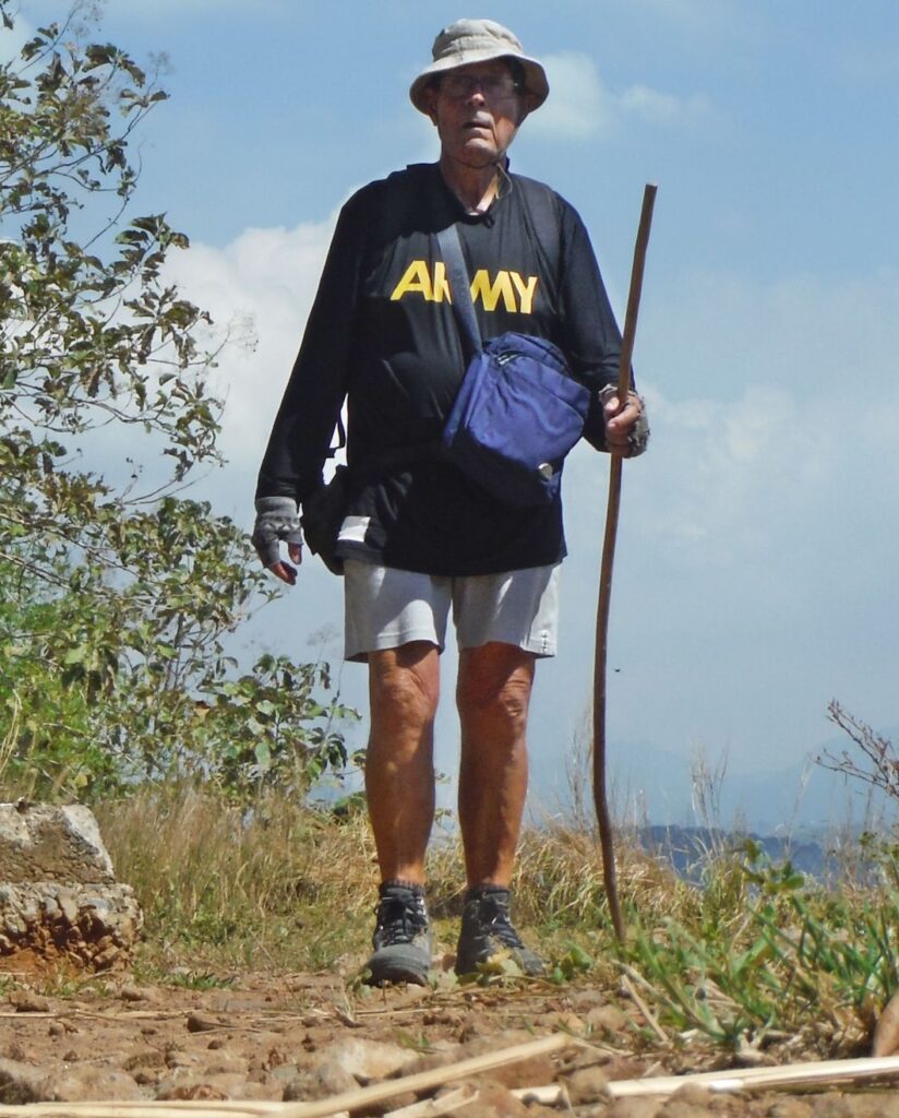 Zf528. (41). Will be 80 in March, not bad; when a Filipino asks me how old I am, I answer “binata pa” (still a youngster)! A new campaign sign, on top of Kalaklan Ridge, overlooking Olongapo! This is one of 17 images of my climb/walk back up to Kalaklan Ridge to where the Magsaysay, and others, political campaign sign was erected. It sure reminded me at the Olongapo Sign that was located here many decades ago. Other campaign signs are pictured, in May will be the National Election for a new President etc. The trail started behind the big Iglesia ni Christ Church here, it went passed many houses on the slope. This group of pictures also includes views of Olongapo. There are 2 pictures of me with an Army shirt; hold your horses with your critique, although ex Navy I love the Army, they are my brothers and this is a good shirt, it says: I’m military! Came across some kids, coming up with me and they were shoveling Mt. Pinatubo Sand for a family home project. 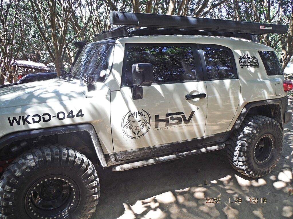 Zf529. (49). Mysterious vehicles at large lot with a pool, which catered to visitors, as late as a year ago. The pool was closed because of the virus from Red China. Very, very seldom does one see vehicles on Kalaklan Ridge because the road is bad. But because of the electrical work here an old trail from Gordon Heights is now usable for vehicles. This is one of 7 images of my walk, uphill along the Kalaklan Ridge, about 3 km up to the 235 meter level. I took two pictures of the new electrical lines. A work team has been up here for weeks and replaced all the electrical wires and fittings. I wanted to check out the swimming pool but it was not only closed, special vehicles were parked there and a man with 2 radios in his hand told me “bawal- in German verboten”. So, I moved on to my descend point the diagonal trail down to the Rizal Extension in Barretto and home. |
|
|
|
Post by Karl Welteke on Feb 6, 2022 18:07:04 GMT 8
High voltage line across Mt. Kalaklan in Olongapo This is the CASTILLEJOS-HERMOSA 500 KV TRANSMISSION LINE PROJECT. It is an important and big project and I decide to upload it high resolution, into this Flickr album. In Olongapo drove to Gordon Heights to the end of Waterdam Road and another 1/2 km on the extension road and parked. Checked with people about parking and got a Ok. I ask and a young boy showed the start of high voltage line service road over Mount Kalaklan but anyone can find it without a guide. It is steep going up and it reaches the top where a cement ranch house is, abandoned, nobody there now. The road continues around the head of the big ravine. I stopped at the last tower before the line goes down to the Sta. Rita River and then I returned. Saw interesting things, bull taken down for slaughter, bunch of carabaos and saw a few possible trails 12 sample images in low resolution have been posted in Facebook, this is the URL, click here: www.flickr.com/photos/44567569@N00/albums/7217772029648291432 images have been uploaded into my Flickr album in high resolution; this is the URL, click here: www.flickr.com/photos/44567569@N00/albums/72177720296482914 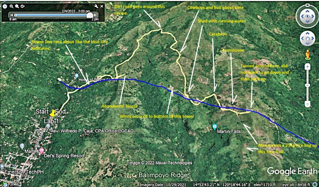 Zf535. This is one of 5 images about my walk along, under the High Voltage Transmission Line across the Mount Kalaklan at Olongapo. The pictures provide my GPS track, data of the walk and show you on maps where this project is and where the walk was. 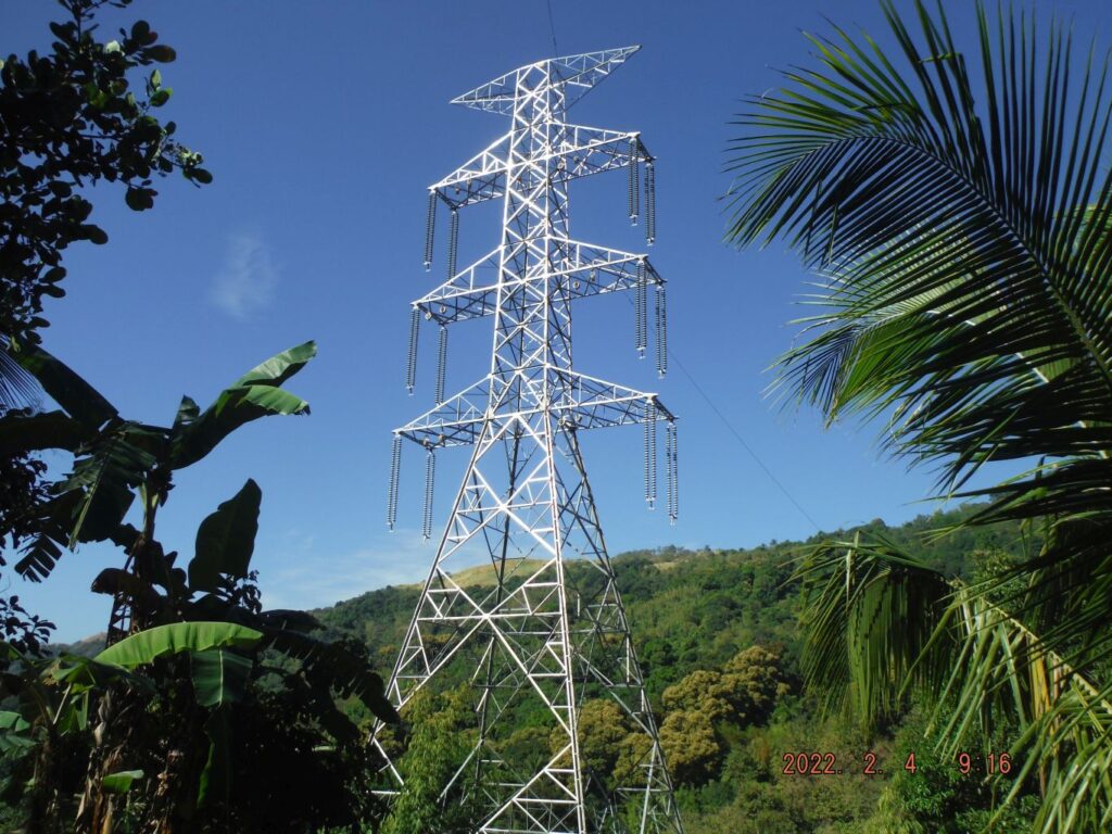 Zf536. This is one of 6 images walking up to the first ridge of Mt. Kalaklan, starting at the Gordon Heights Valley in Olongapo. The line makes it up with three towers. It was easy to cross the Mabayuan River coming out of the Gordon Heights Valley. An 11 year boy had showed me the start of this new power line service road and then hitched up with me. On top is an abandoned ranch house, I was familiar with area of this house but it is abandon now. I convinced the young boy to return that my walk was too long, too far away from his family. There is a nice view of a deep and long ravine, not visible, at the end is the Sta. Rita River and Barrio Tabacuhan. 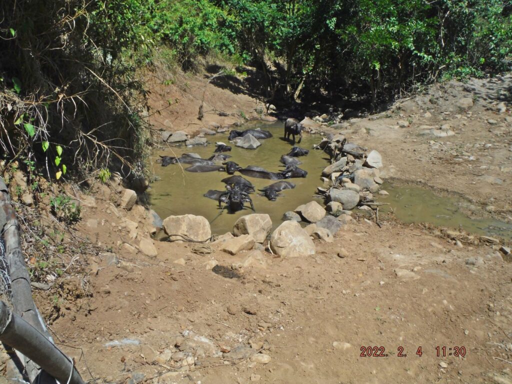 Zf537. This is one of 6 images as I walked to my turnaround point where I could see the new power line crossing the Sta. Rita River and coming/going across the PLDT Mountain. I saw 11 Carabows in their wet element, the manned farm/ranch house, view towards the north, east and south. I saw a trail, I still looking for new trail up to this Kalaklan Mountain. 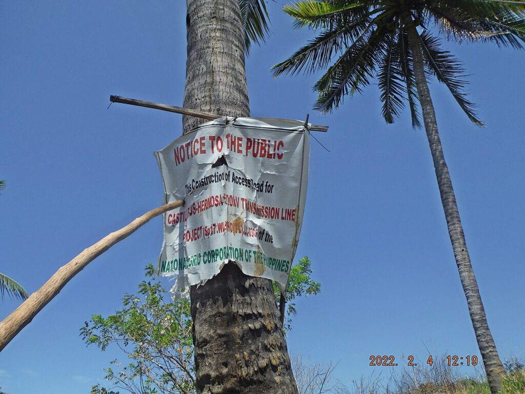 Zf538. This is one of 7 images of my return walk; the pictures are in this order: -1= a view to the ridge where I came up on and a large and short ravine between and a short ridge between those. -2= a sign of this project, CASTILLEJOS-HERMOSA 500 KV TRANSMISSION LINE PROJECT. -3= a man at the small ravine where the carabows were, getting ready for lunch, this is also near the farm/ranch house. -4= the shed with running water in troughs and I saw other animals besides cattle and carabows, there were horses and goats. -5= the bull is temporarily tied up, the cowboys are trying to catch one more. -6= the gate next to the tight-up bull and this is also the area where I bypassed or over hauled this catch the cattle event. The reason I show this is that it seems this whole Kalaklan Mountain is divided in about 4 grazing areas with fences and gates separating them. -7= came across my cowboy friends again who said that another bull or piece of cattle got away from them and they returning to the first bull. |
|
|
|
Post by Karl Welteke on Mar 6, 2022 17:08:57 GMT 8
Botolan Tarlac Road as of 3rd March 2022. On the 3rd of March 2022 I Inspected the Zambales-Tarlac Road again. A tricycle gave me a ride and I saved approximately 6km of my walk. The concrete seems to be going all the way to the Balintawak River at the Poonbato area. I only went to the 400 meter level where the road descends down to Poonbato and returned. I noticed 6 new bridges done or in progress. But work on the road seemed to be stopped. Also it is not clear to me how the road route will connect to the road coming from Tarlac. I have reported before on the Botolan-Tarlac Road condition in 2017 in the Corregidor Forum, starting at this Page and it continues into the next one, click here: corregidor.proboards.com/thread/1655/excursions-philippines?page=4For this 2022 walk, 34 images have been posted in my Flickr account in high resolution, click here: www.flickr.com/photos/44567569@N00/albums/72177720297153851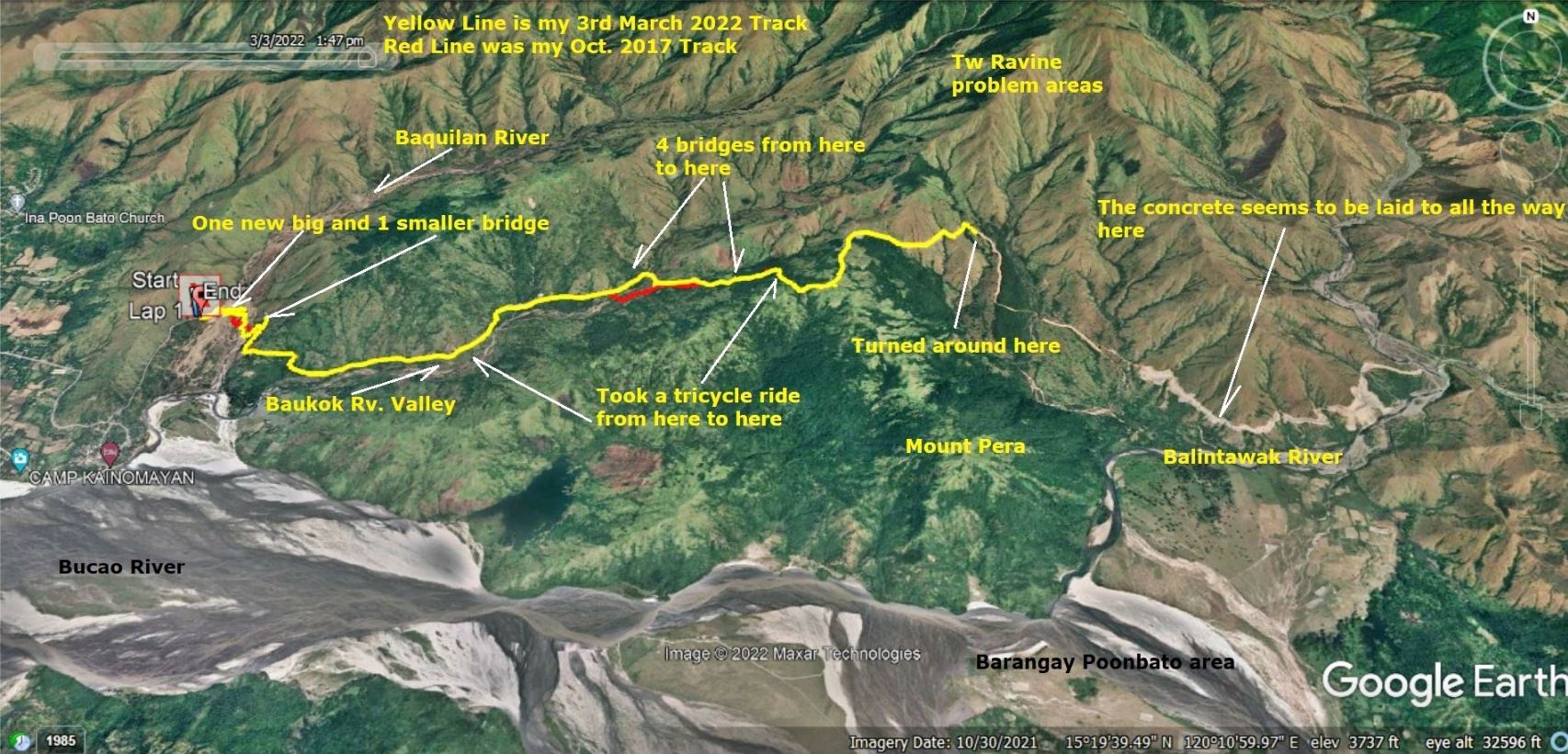 Zf558. My 2017 track, red and my 2022 track, yellow of my walk along the Botolan-Tarlac Road from the Zambales side. 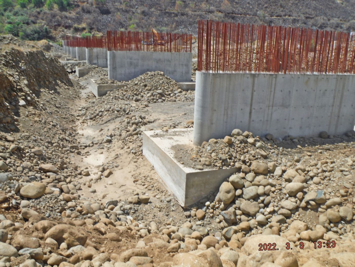 Zf559. The new unfinished bridge over the Baquilan River for the Botolan-Tarlac Road. This is a picture of a view of my walk along the new Botolan to Tarlac road on the Zambales Province side. 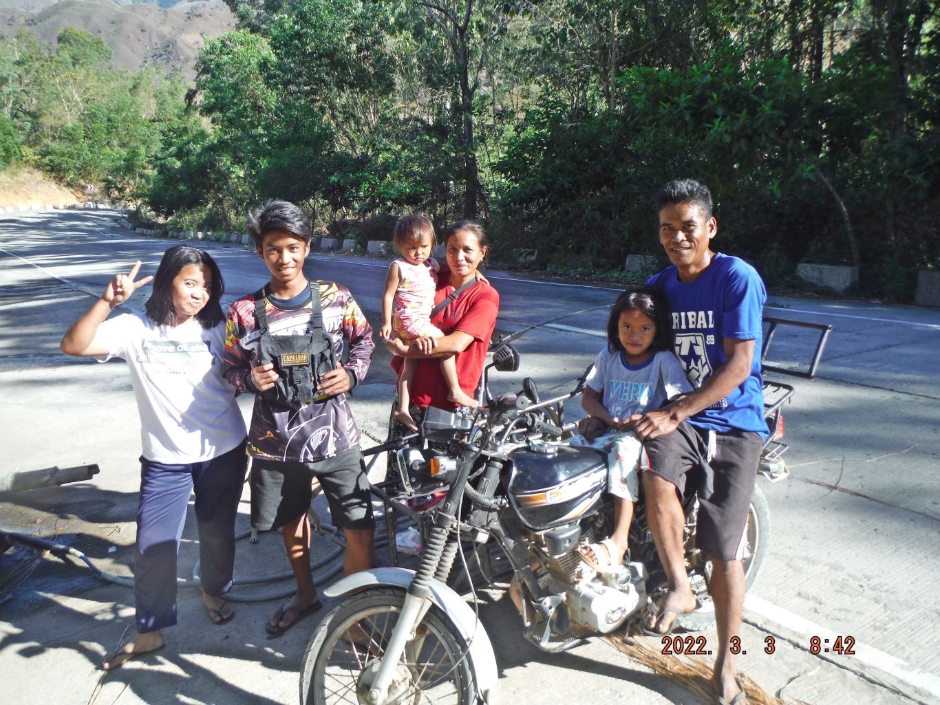 Zf560 The family that gave me ride with a tricycle and saved me maybe 5 or 6 km of my walk on the Botolan-Tarlac Road. This is a picture of a view of my walk along the new Botolan to Tarlac road on the Zambales Province side. 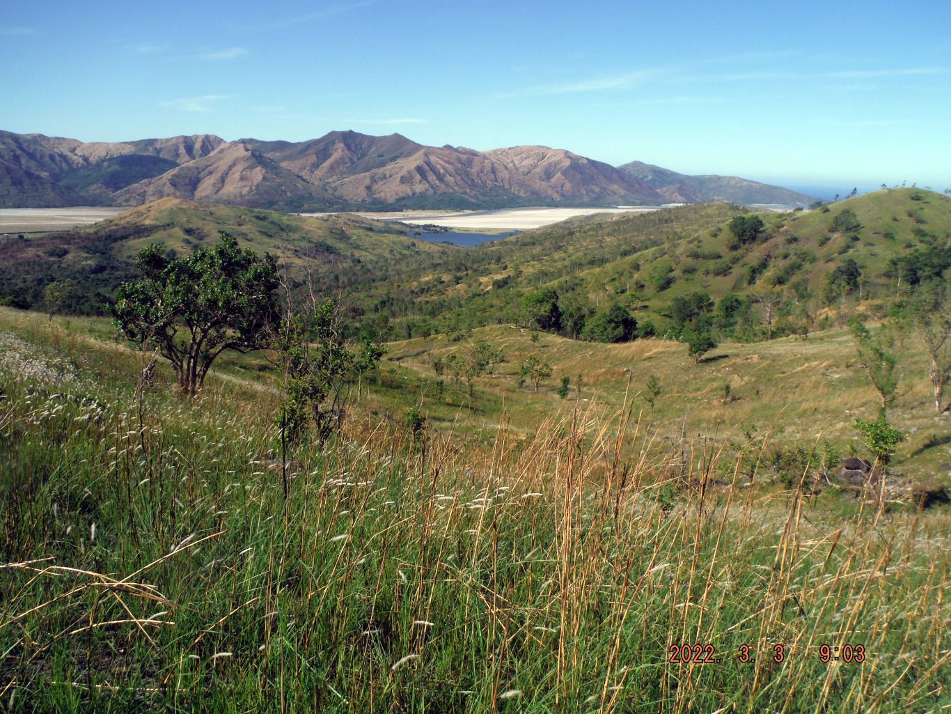 Zf561. This is a view down the Malumboy River Valley and we can see the Mount Pinatubo Lahars caused another lake in the valleys around Mt. Pinatubo. In back we see the Bucao River and all its Lahar in the direction of the Philippine West Sea. (Formerly called South China Sea). This is a picture of a view of my walk along the new Botolan to Tarlac road on the Zambales Province side. 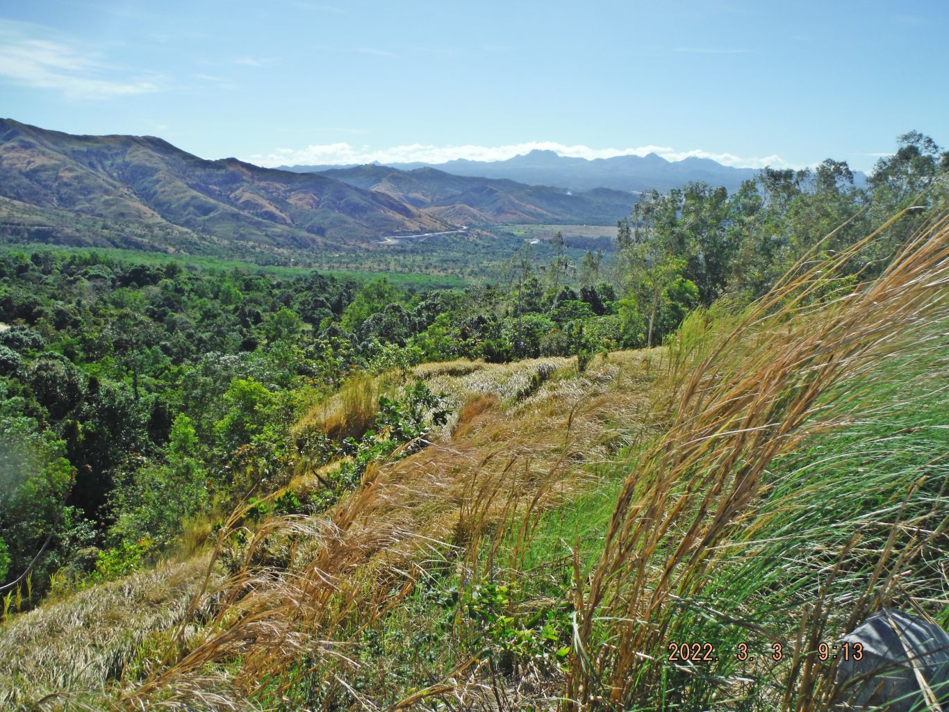 Zf562. The Barrio Poonbato area and the new Botolan-Tarlac Road are in sight as it approaches the Balintawak River. This is a picture of a view of my walk along the new Botolan to Tarlac road on the Zambales Province side. 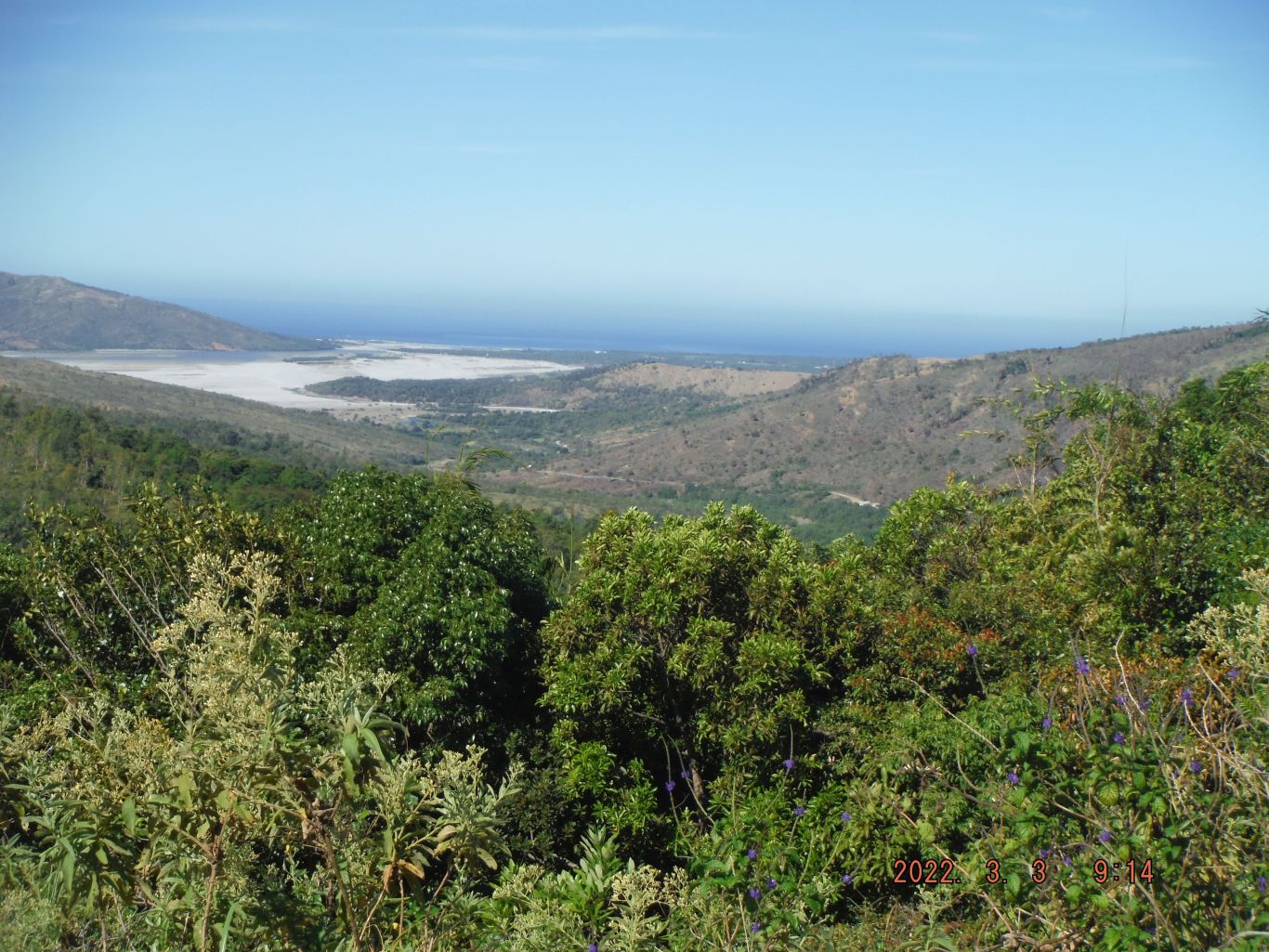 Zf563. Looking back towards the mouth of the Baquilan River flowing into the Bucao River. This is a picture of a view of my walk along the new Botolan to Tarlac road on the Zambales Province side. 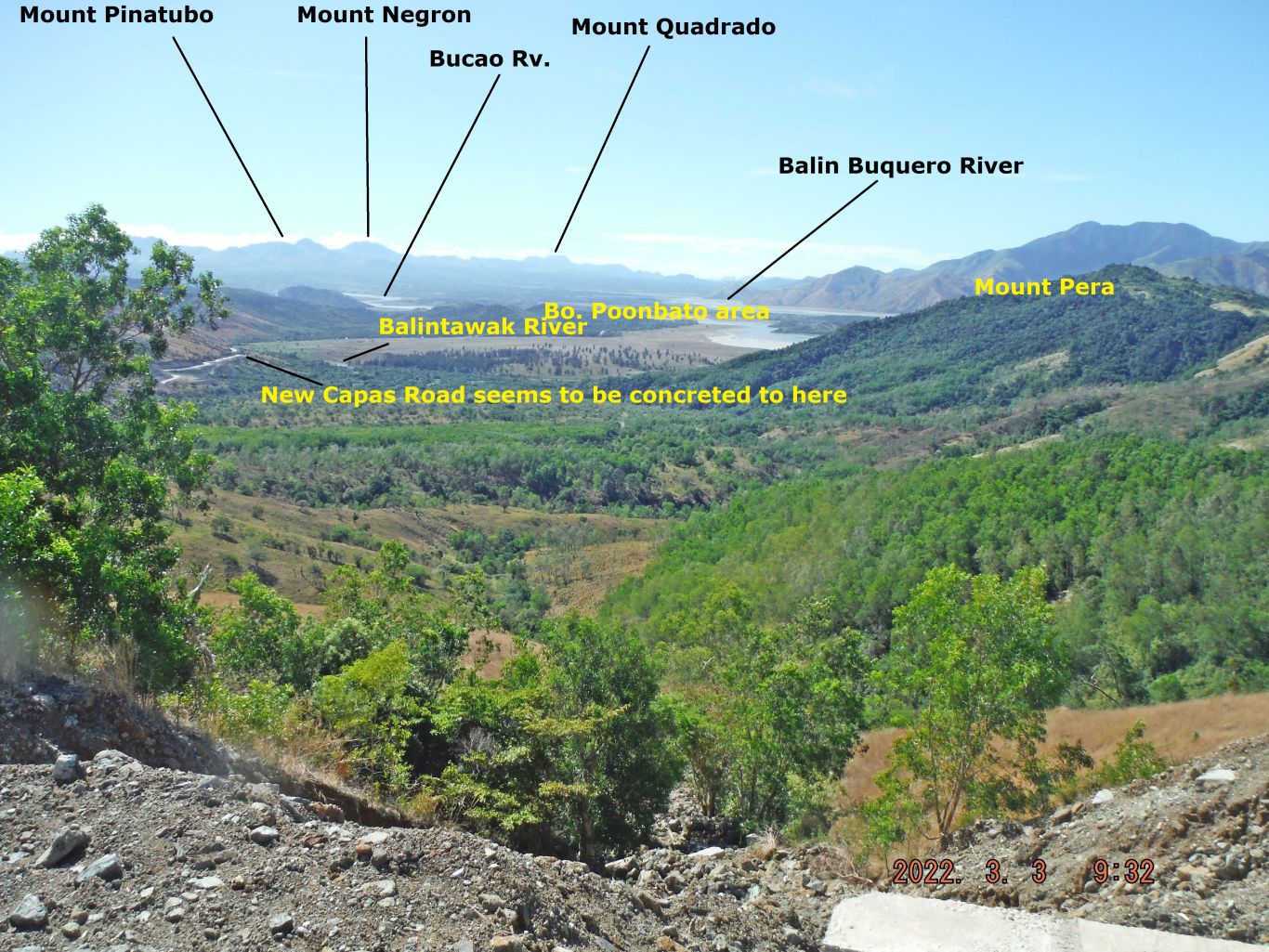 Zf564. The Barrio Poonbato area and the new Botolan-Tarlac Road are in sight as it approaches the Balintawak River. This is a picture of a view of my walk along the new Botolan to Tarlac road on the Zambales Province side. 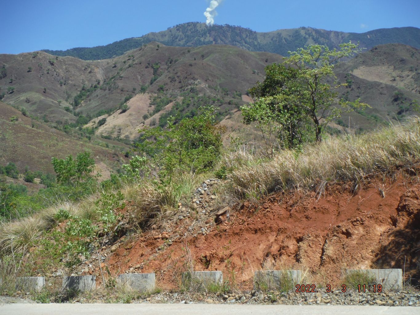 Zf565. A fire on top of a high mountain; I never saw that before. This is a picture of a view of my walk along the new Botolan to Tarlac road on the Zambales Province side. 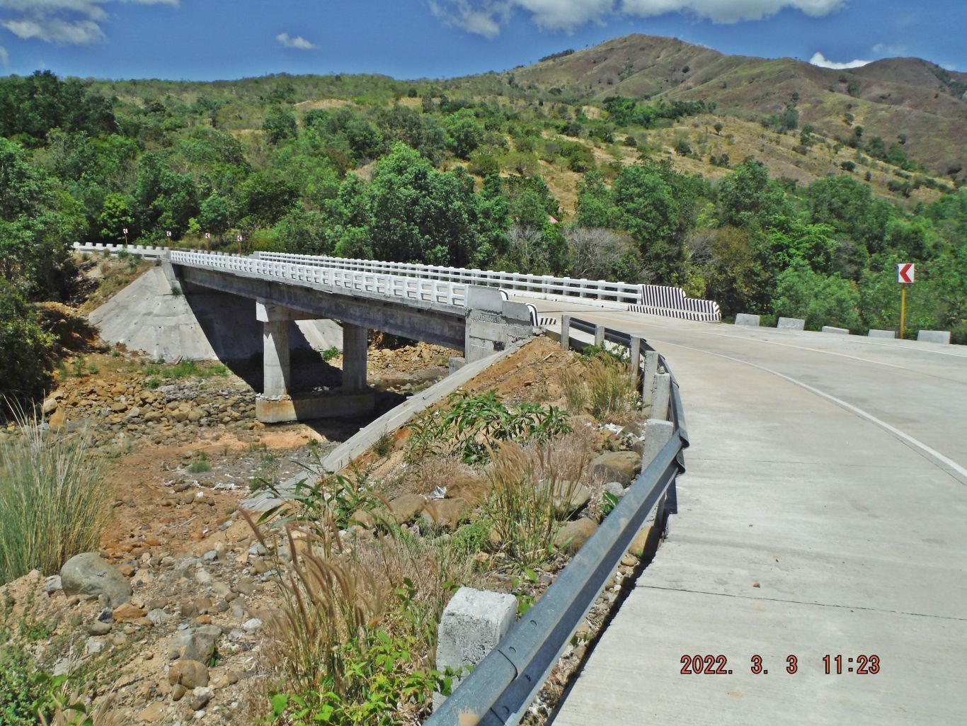 Zf566. Bridge #2 going back towards Botolan. This is a picture of a view of my walk along the new Botolan to Tarlac road on the Zambales Province side. 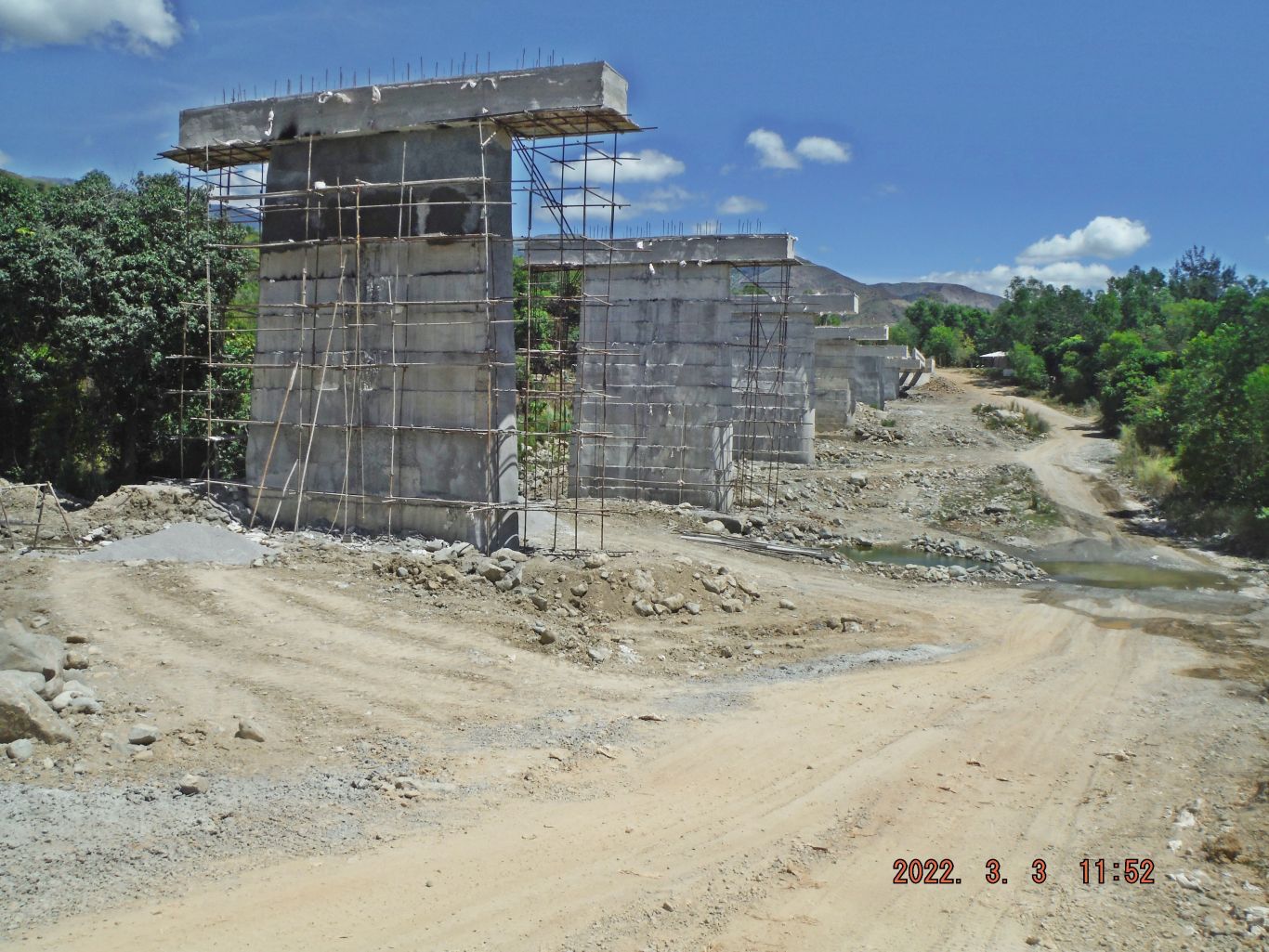 Zf567. Bridge #4 going back towards Botolan. This is a picture of a view of my walk along the new Botolan to Tarlac road on the Zambales Province side. |
|
|
|
Post by Karl Welteke on Mar 10, 2022 14:14:51 GMT 8
2022-03-09 Nagsasa Ridge, views from Charlie’s and Karl’s (his 80th BD) hike up to the North Pass of the Nagsasa or Nazasa Ridge from Cawag to the Nazasa Cove on the 9th of March 2022. Some pictures have location names imprinted. And look for the round of picture from left to right from the top of the pass with detailed name descriptions. This is on the Redondo Peninsular in Subic Bay. 55 images of this hike were uploaded into this Photobucket album: app.photobucket.com/u/PI-Sailor/a/70b4cd72-6ce2-4aee-a746-0e0176d5989f22 images, short version, were uploaded to my Facebook:  U878. One of 6 images of Charlie’s and Karl’s (his 80th BD) hike, with maps, hike data & GPS track up to the North Pass of the Nagsasa or Nazasa Ridge from Cawag to the Nazasa Cove on the 9th of March 2022.  U879. This is one of 12 shot of a Round of Scenic Images, shot from left to right (clockwise), from the top of the North Pass of the Nagsasa or Nazasa Ridge from Cawag to the Nazasa Cove on the 9th of March 2022. For your orientation names of the mountains or locations have imprinted.  U880. Charlie and I have returned to the Cawag side of the Pagsasa Ridge, we made it. It took us 3 hours and 50 minutes to get up there. Next week I will walk up there again and down to Nazasa Cove. We are shipmates from way back, both were Navy Deep Sea Divers and we were stationed at the same command 4 times in our 30 years of service each. |
|
|
|
Post by Karl Welteke on Mar 18, 2022 19:17:33 GMT 8
Nagsasa Cove Hike, 2022-03-15 In this forum presentation I chose these 9 images, picture serial numbers referred to, are based on the 155 images in the long Photobucket album. This is a challenging hike on the Redondo Peninsular, it separates the bay of Subic Bay from the South China Sea (here in the Philippines it is now called the Philippine West Sea). This area was part of the Olongapo Naval Reservation and was used as a target site for aircrafts and ships. Had my wife drop me off at Sitio Abot, part of Barangay Cawag, at the end of the concreted road. That is in the Cayuag River Valley, west of the Subic Municipality and it drains into Subic Bay. They just started to extend the concrete Road. Started the walk about 6 am and it took me about 5 hours and 50 minutes, I’m getting old! I brought with me about 50 pictures of the people at that cove which I had shot in 2008. On the way up to the north Pass, I came across two young men and one of them was a child on one of those pictures. It had rained the night before, the trail was damp but it was no problem. It turned out to be a great day. I enjoyed the views going up and going down on the other side. A lot more activity is going on now, 14 years later from my visits in 2008. I dropped of the pictures and many people were happy to see themselves again 14 years before. I hired a boat, probably for too much money, 2000 peso and went to Punduquit. I treated myself to a meal at the CMC Bar & Grill-Double Suds Car Wash and Shot the Bull with the Boss, Chris. Then trice to San Antonio and a bus to Barretto. It was another great day in the PI. If you are interested I uploaded the pictures into these three albums: Uploaded to my Facebook account as an album with 48 images: www.facebook.com/media/set/?vanity=karlwilhelm.welteke&set=a.10223589320274788Uploaded 48 pics of my Nagsasa Hike, 2022-03-15, into this Photobucket album, Philippines. Zambales, Redondo Peninsular, short version: (Same pictures as in Facebook) app.photobucket.com/u/PI-Sailor/a/caa20602-6e84-4085-afc8-5a15d9c205b3Uploaded 155 images of my Nagsasa Hike, 2022-03-15, into this Photobucket album, Philippines. Zambales, Redondo Peninsular: app.photobucket.com/u/PI-Sailor/a/79c7edcc-4584-443a-80d6-e98d5e68f85cPicture descriptions for these 9 images:  Zf576. Pic #01: One of 5 images with my GPS track, and walking data from my Garmin GPS device and track account. 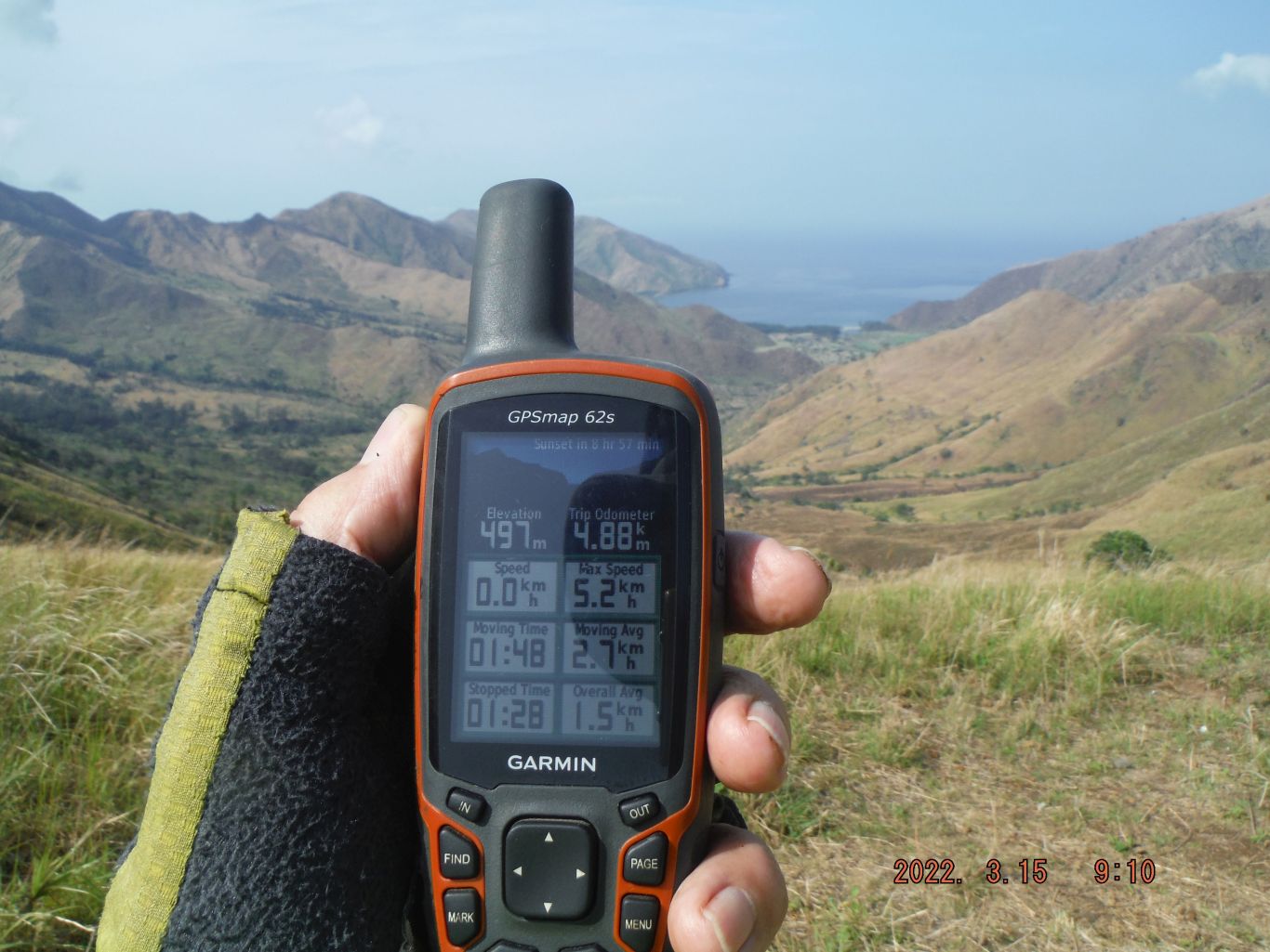 Zf577. Pic #13: One of 15 images of my hike to the Nagsasa Cove from Sitio Abot in Cawag to the North Nagsasa Ridge Pass. The Cawag Road is being extended. We see the trail on the bottom, clouds still hanging just under the Nagsasa Ridge (also spelled Nagzasa Ridge) and under the Pointed Peak (the name on my map). I meet two young men coming from Nagsasa Cove, one of them was a boy on my 2008 pictures. I reached the North Pass in about 3 hours and 16 minutes, I’m getting old! Caught the first great views of the cove. Got shots of my GPS devise and even 2 selfies with my camera. 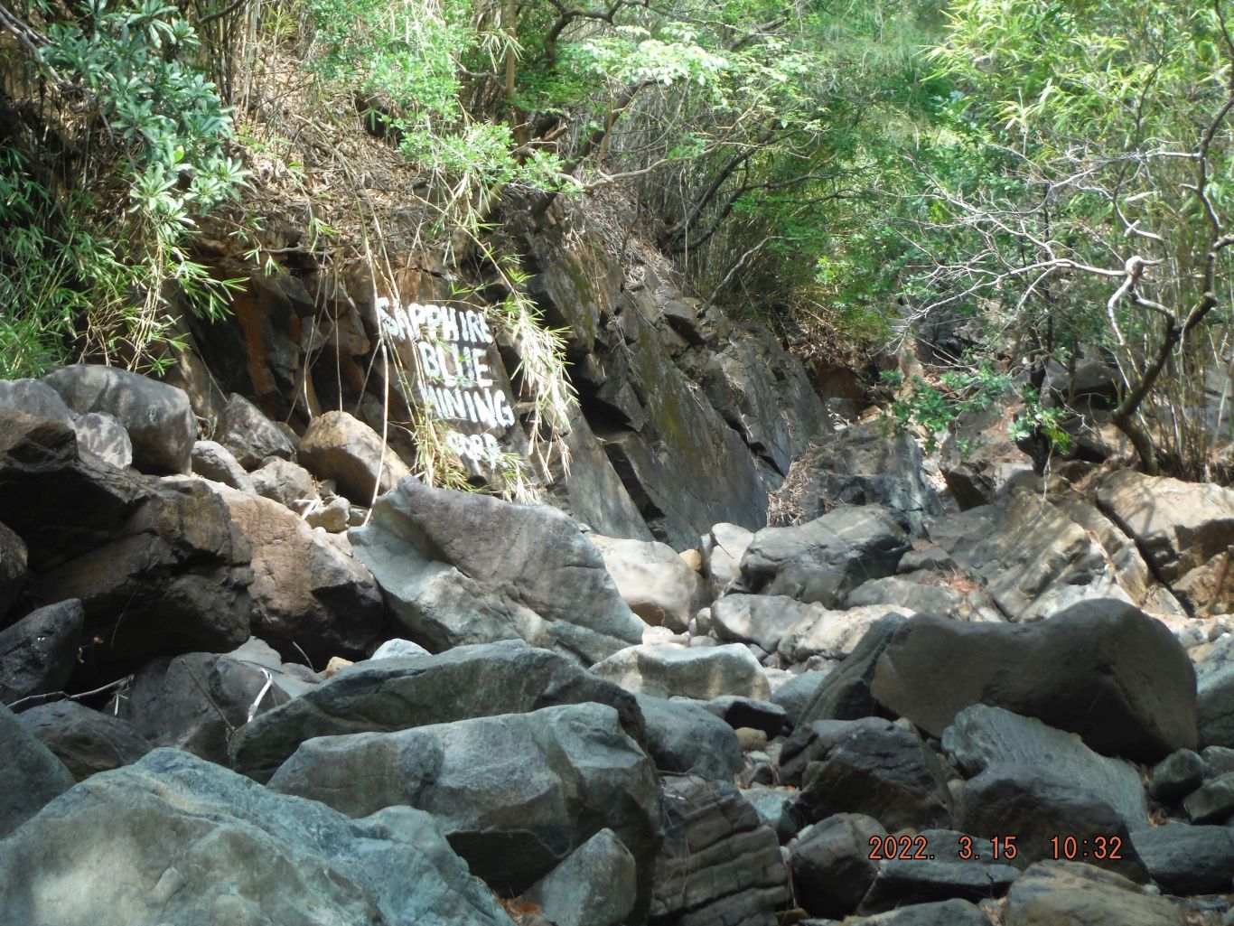 Zf578. Pic #41: One of 18 images descending down from the about 300 meter level to the 100 meter level thru woods, across the first river of stones where the chromite mine operation was going on about 15 years ago. Several piles of chromite were still in the area. These pictures are numbered #33 to #50. Thru out this album, I shot rounds of pictures always from left right, clockwise. A piece of history, this whole valley was used by the US Navy as a Bombing and Strafing Range. For all I know, ships may have used it too. According to one Officer Friend I have, it was done pretty much to the end of our management but perhaps very few times toward the end of our stay. Around the year 2000 Canadian George and I descended to the cove via the South Pass and saw vehicles there, placed by helos, for targets. Then a lot more cattle were in the valley and we had many cow trails to descend on. 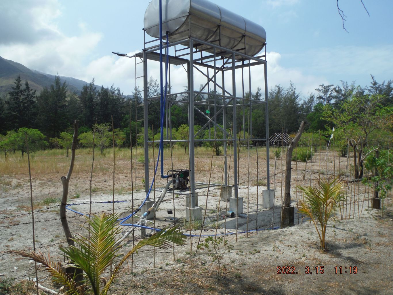 Zf579. Pics # 049. This is one of 31 images from the Ridgeline End, where the big river had to go around, where this trail had to go around and cross the river first. Then we have pictures crossing the Nagsasa Valley floor to the Sitio Nagsasa tree line. Sitio Nagsasa is sitting on a long sandbar which runs parallel to the long cove beach, along with trees that grow the whole length of the sitio and beach. Inland of the sandbar is a riverbed that has water at high tide and several bridges are now constructed to cross that water at high tide. And these pictures show as I cross the best bridge, about center of the sitio and we see the first facilities of this Nagsasa Cove. These pictures are numbered #030 to #060. 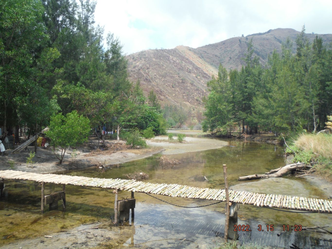 Zf580. Pics # 056. This is one of 31 images from the Ridgeline End, where the big river had to go around, where this trail had to go around and cross the river first. Then we have pictures crossing the Nagsasa Valley floor to the Sitio Nagsasa tree line. Sitio Nagsasa is sitting on a long sandbar which runs parallel to the long cove beach, along with trees that grow the whole length of the sitio and beach. Inland of the sandbar is a riverbed that has water at high tide and several bridges are now constructed to cross that water at high tide. And these pictures show as I cross the best bridge, about center of the sitio and we see the first facilities of this Nagsasa Cove. These pictures are numbered #030 to #060. 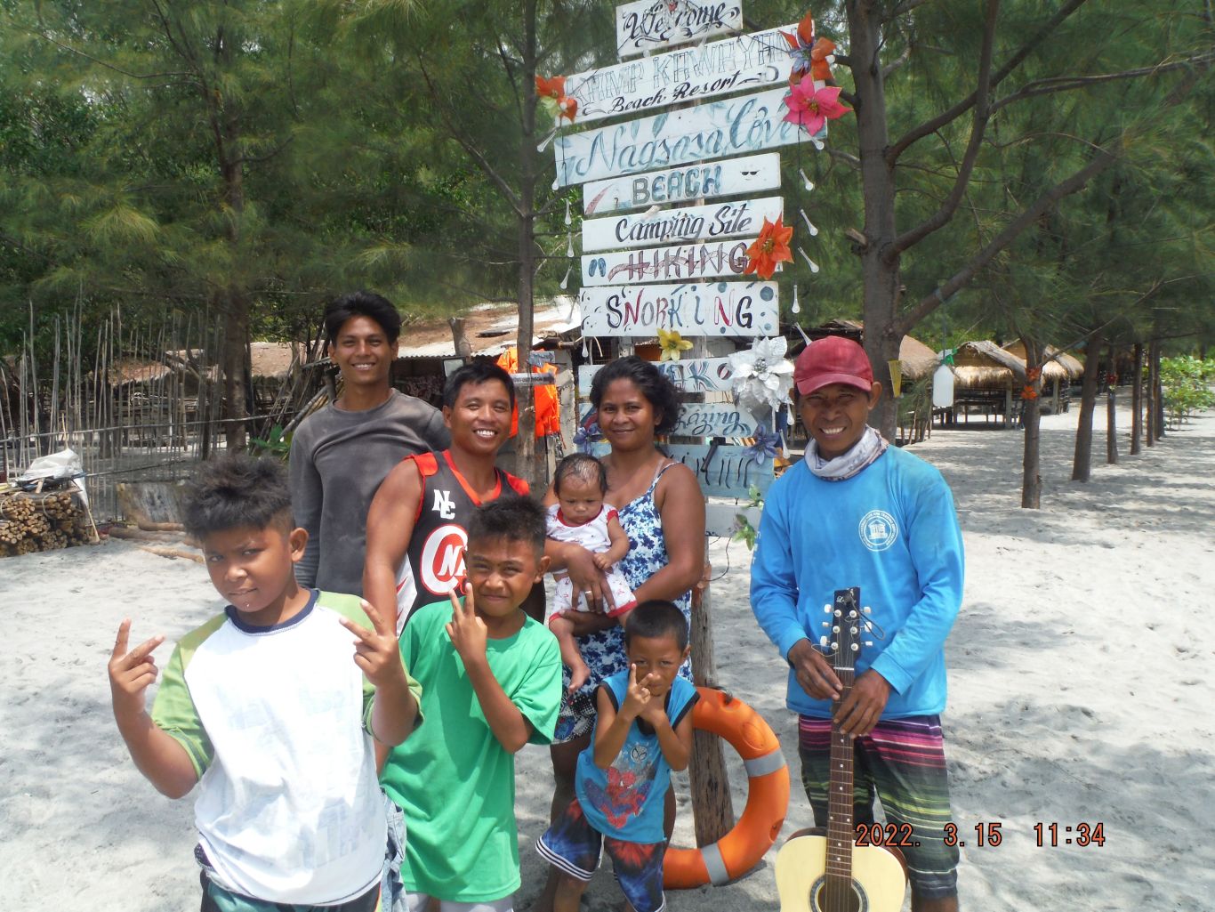 Zf581. Pics # 062. This is one of 44 images of the facilities available in Nagsasa Cove, grand views of cove and its beach and the ridge lines surrounding it. The pictures in this album are sorted alphabetical and in the order they were shot and are numbered #061 to #105. The first and last pictures show the people I shared the pictures with, which I had brought and the boat I hired to go to Pundaquit. 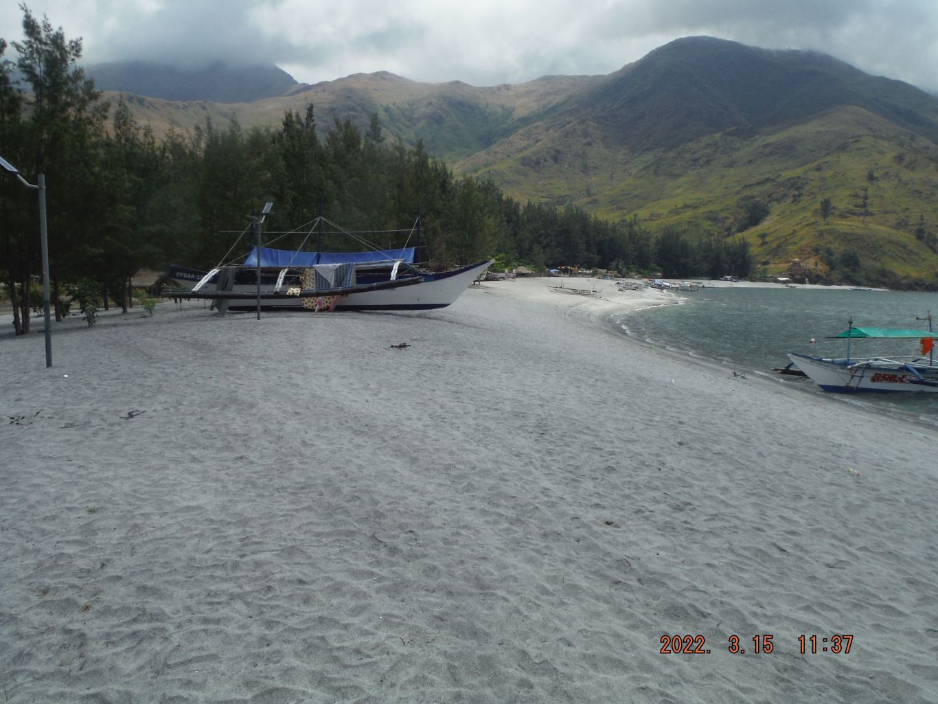 Zf582. Pics # 063. This is one of 44 images of the facilities available in Nagsasa Cove, grand views of cove and its beach and the ridge lines surrounding it. The pictures in this album are sorted alphabetical and in the order they were shot and are numbered #061 to #105. The first and last pictures show the people I shared the pictures with, which I had brought and the boat I hired to go to Pundaquit. 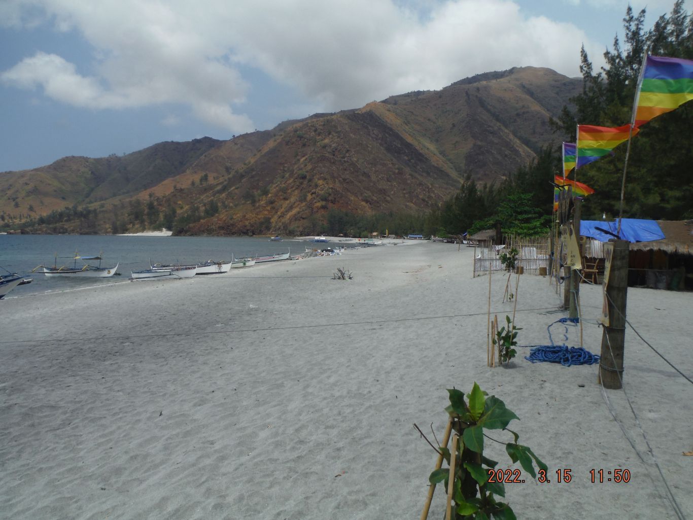 Zf583. Pics # 076. This is one of 44 images of the facilities available in Nagsasa Cove, grand views of cove and its beach and the ridge lines surrounding it. The pictures in this album are sorted alphabetical and in the order they were shot and are numbered #061 to #105. The first and last pictures show the people I shared the pictures with, which I had brought and the boat I hired to go to Pundaquit. 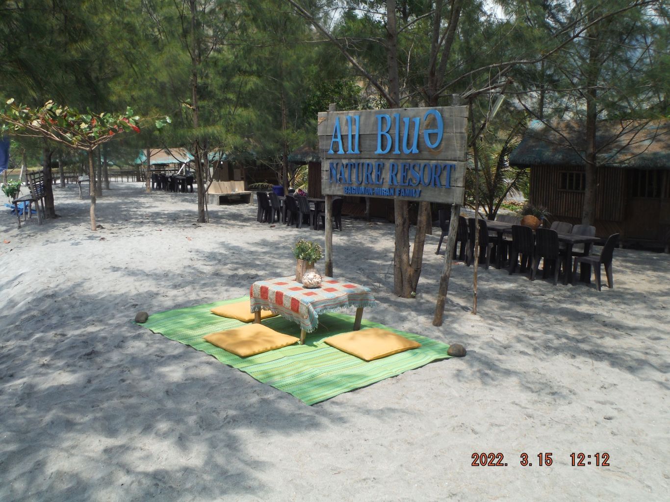 Zf584. Pics # 099. This is one of 44 images of the facilities available in Nagsasa Cove, grand views of cove and its beach and the ridge lines surrounding it. The pictures in this album are sorted alphabetical and in the order they were shot and are numbered #061 to #105. The first and last pictures show the people I shared the pictures with, which I had brought and the boat I hired to go to Pundaquit. |
|


.jpg?width=1920&height=1080&fit=bounds)


