|
|
Post by okla on Apr 18, 2009 0:12:36 GMT 8
hey fots....great shots as per usual. certainly brings it to life for me. although war plan orange always envisioned that amer/fil forces would occupy bataan and the island forts until relief arrived from the US, these trench systems reinforce my belief that someone in decision making positions realized that there could be a distinct possibility that japanese forces could be in possesion of bataan and would be in a position to attempt a landing on the north shore of corregidor. thus fortifications facing, not out to sea, but toward bataan and the tail of the island were emplaced at key positions. one wonders just how many of these folks actually doubted the feasibility of that part of Orange and that corregidor (and the other forts) would be standing on their own, totally exposed from bataan and its heights. as i have said before, aint hind sight wonderful????postscript....i have never enjoyed the delights of san miguel beer, since my attempted transfer to clark field back in 1953 didnt transpire for me, but i can testify to the merits of nippon, asahi and kirin beers of japanese origin. i have a neighbor, here in tulsa, who was at subic for 36 months and he testifies to the merits of san miguel. i have mentioned this guy previously, either on this board or the philippine scout site, and how he had no sense of history and never had the inclination to visit bataan, corregidor, or any other locations in the PI that i would give anything to have seen. it takes all kinds, i guess. thanks again for all your great contributions to this website. i will quit pestering you for now, but will keep trying to think up more hidden sites for you to prowl over.
|
|
|
|
Post by fots2 on Apr 18, 2009 14:30:05 GMT 8
Here is one last photo for you okla. One of many Japanese bottles that can be found on Corregidor today. I found this one in Battery Sunset's magazine. DIA NIPPON BREWING COMPANY LIMITED 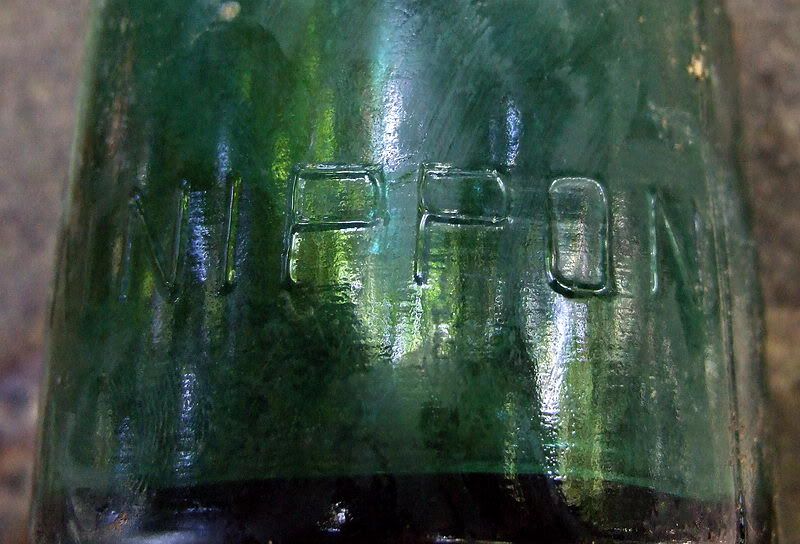 |
|
|
|
Post by okla on Apr 19, 2009 1:46:23 GMT 8
hey fots....that is certainly what i would call an ARTIFACT of the first degree. isnt it strange how one's memory can play tricks on a person??? i remember the nippon bottles that i drained being brown, but maybe the ahasi bottles were the brown ones. whatever, the contents got the job done, but nippon was my first choice. those were, absolutely, the best days of my life. at this stage of my existence, i have forgotten pulling KP, or CQ (later in my hitch when i was a staff sergeant) on christmas day or new years eve. just the good times remain filed in the front portions of my mind. nostalgia is running amok with me these days.
|
|
|
|
Post by okla on Apr 19, 2009 1:56:28 GMT 8
hey fots...one last thing before i sign off for a while. the logo that you use on your posts (the one of the sunset over bataan) is, i think, one of the most striking photos i have ever seen. so much so that i have it as the background on my computer screen when it is sitting idle. i dont think i will ever tire of viewing it. just thinking about pulling a hitch on corregidor, watching sunsets such as is portrayed in the photograph, is enough for a guy back in the 1920s and 30s to keep re-enlisting indefinitely. i suppose there were more than a few who did that very thing and ended up in japanese prison pens, doing slave labor up north, drowning when their "hell ship" went down under US bombs or torpedoes or dying defending the beaches out on the tail of the island.
|
|
|
|
Post by fots2 on Apr 19, 2009 10:59:09 GMT 8
okla, that little logo is a color saturated version of a full size photo I took at sunset from the Corregidor Inn a few years ago. Here is two more the soldiers might have seen. The first one was taken in February this year. Phantom and I were sitting at MacArthur's when he said "turn around". I grabbed my camera and took this from Lorcha Dock looking west over the North Dock. The sun had already set but the color remained for a long time. 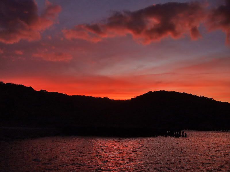 The second one was taken last month when my sister was visiting from Canada. I took her on the hotel's sunset tour to Battery Grubbs. 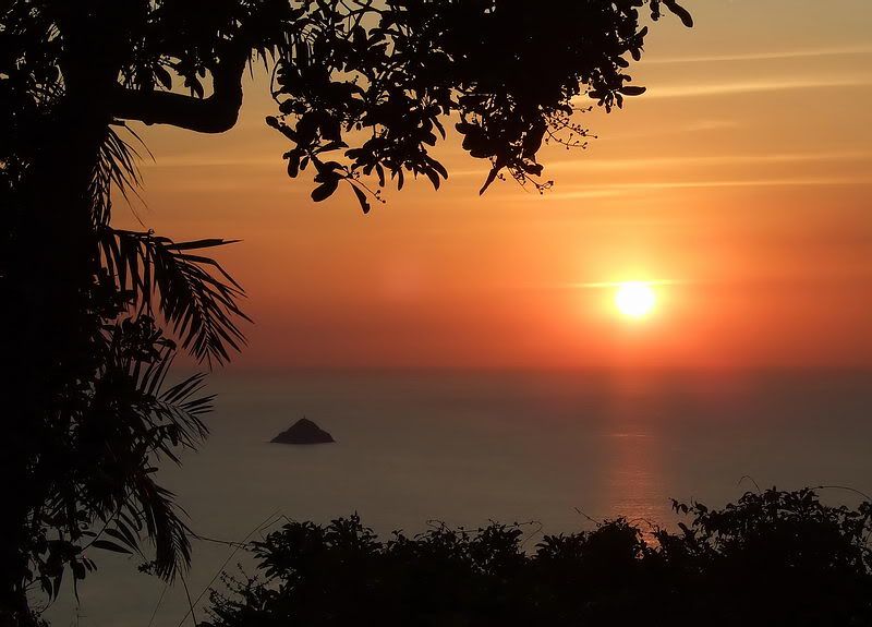 If someone has no interest in the history of Corregidor, there is still a lot of beauty there today. |
|
|
|
Post by okla on Apr 20, 2009 6:53:03 GMT 8
terrific shots, especially the one taken from battery grubbs. other than typhoon season, are all the sunsets this gorgeous in the PI????evidently they are all eyepopping. somewhere on this board or the philippine scout website there is a sunset pic taken at Truk lagoon. i wouldnt be surprised if your fingerprints are all over it. it seems to be the same MO. the pic taken down at the former Japanese naval fortress is excellent, but not in the same league as the sunset over bataan photo. there is just something about it that reaches out and grabs me. as i said, i use it as my computer screen background. every time i walk by i can take a gander at it. having the interest in corregidor and being there to view the beauty as you are able to do is an unbeatable combination. how i envy you. thanks again for making it possible for me to enjoy the next best thing from half a world away in tulsa, oklahoma.
|
|
|
|
Post by fots2 on Apr 20, 2009 7:51:40 GMT 8
You are very welcome okla. Next time I am on Corregidor I will have a look for the cemeteries you mentioned and let you know.
I was at Truk Lagoon once. The trip was primarily for scuba diving but I explored around also.
Have a good day.
|
|
|
|
Post by fots2 on Jul 11, 2011 8:01:43 GMT 8
Hey okla, I thought this thread was dead forever but I have something new for you. While wandering around Tailside last week I came across another one of those concrete trench lines. It is not shown on any map however the 1941 Emergency Defense Map does show two machine guns and one 37mm gun to be sitting exactly where the trench line is located. This was part of the Final Defense Line. 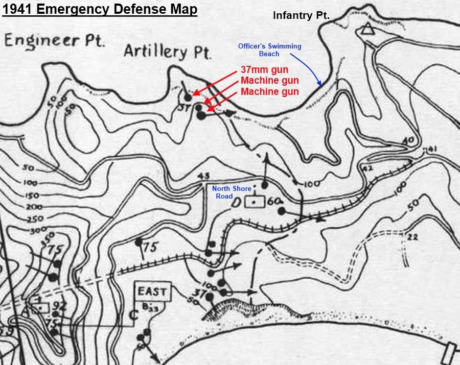 Part of the 1941 Emergency Defense Map (Emergency Defense Dispositions) By far, this trench line is the longest one I have seen anywhere on the Corregidor island. The overall length is 101 meters (331 feet). The trench has three intermediate turns and follows the ridge almost north to south from Artillery Point to near the North Shore Road. This follows the northern section of the Final Defense Line as shown on the 1941 map. The northern end of the trench has significant battle damage but most of it is very intact. I had seen the gun positions on that 1941 map in the past but thought that they might have been placed in small individual positions since nothing else was indicated to be there. I had no idea such a long concrete defense line existed. A series of five concrete trench lines made up the Final Defense Line that stretched across the island from the north shore to the south shore. 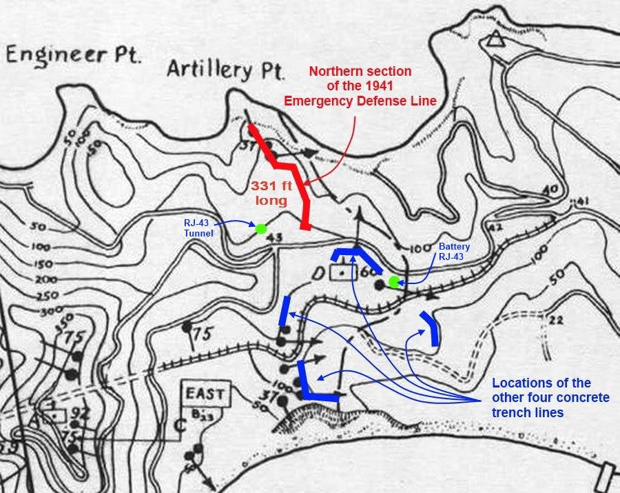 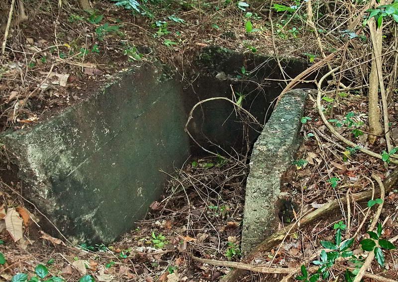 Southern entrance to the trench line. 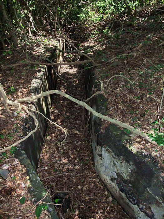 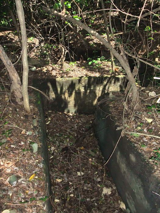 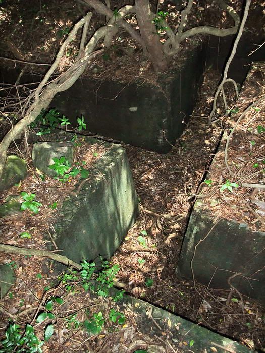 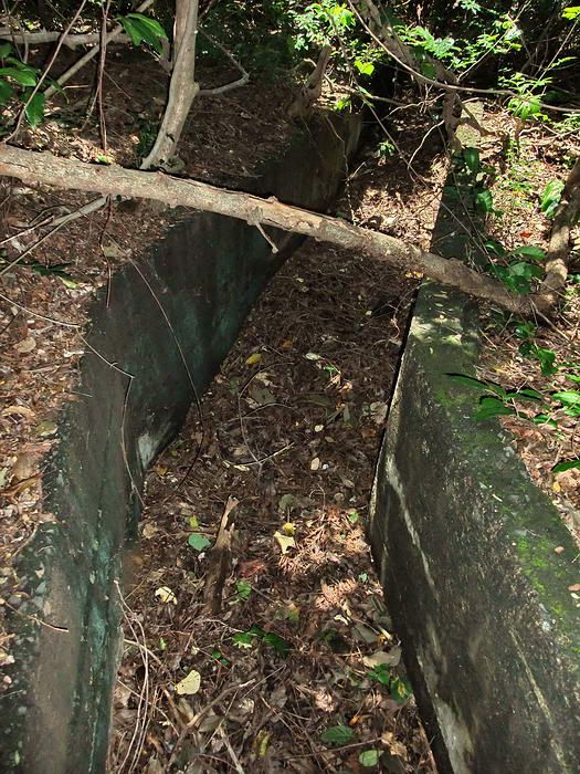 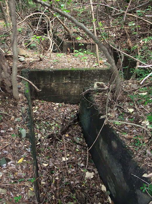 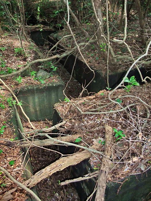 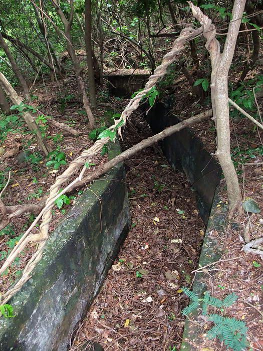 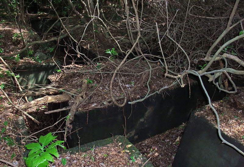 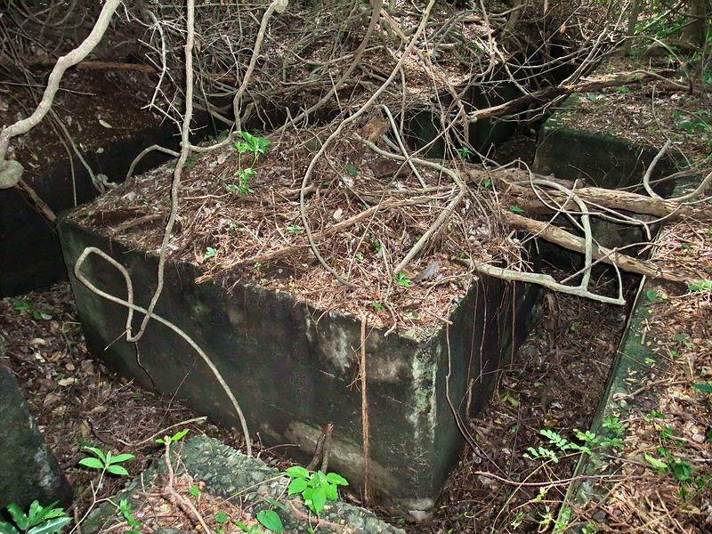 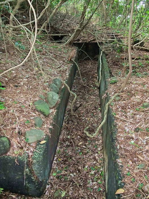 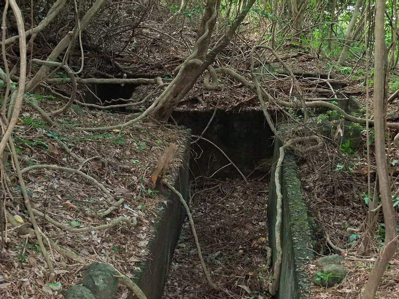 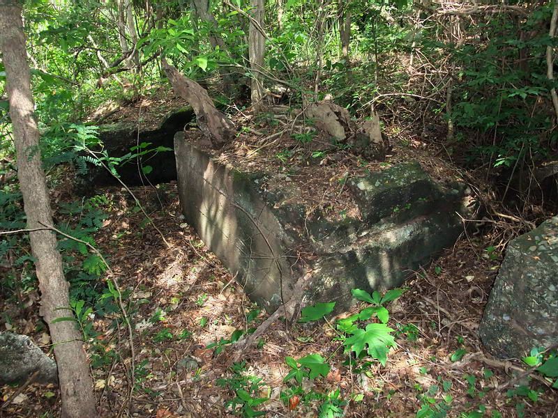 Near the cliff at Artillery Point, the trench line has some damage. Concrete seems to go right up to the cliff face and the trench has no defined end like the opposite end does. The trench line may have been even longer if the cliff face has eroded a bit.  View at the northern end of the trench line on Artillery Point. Officer's Swimming beach is below with Infantry Point in the distance. Now for a bit of speculation, if history had no wrinkles then we have nothing to talk about at night over a beer. Remember our recent discussions on Battery RJ-43 and the RJ-43 tunnel? corregidor.proboards.com/index.cgi?board=threads&action=display&thread=587&page=10 Reply #185 I have seen text that states that Battery RJ-43 definitely had a tunnel. Many tunnels were built around same time. The RJ-43 tunnel we see today is the only one remaining in the immediate area but by no means should we assume that this one was associated with the battery. This particular tunnel is far away the gun crew (486 ft) and in an awkward place to store powder and heavy shells. Was the RJ-43 tunnel built to shelter troops and store small arms ammunition for this nearby trench line? Of course I cannot answer that question. We do not know this tunnel’s purpose so it is a definite ‘maybe’. |
|
|
|
Post by okla on Jul 11, 2011 11:13:59 GMT 8
Hey Fots....I have been clinging to the hope that this new "fix", of which you spoke previously, would arrive before convulsions began to seize me and, without fail, you have come to my rescue with more excellent stuff. With the discovery of this latest and more extensive trench line, it would appear that the final defense line was rather formidable. Especially so, if manned by trained infantry personnel. This fortification is the length of an American football field and made of concrete. That is quite an obstacle for any attacking force to penetrate. As stated before, I will always be curious as to just when the decision was made to construct defensive positions to repel invaders coming from Bataan with the intention of landing on the North Shore and Tailside. Plan Orange assumed that the Peninsula would be held until reinforcements arrived from the West Coast. At what point did some visionary on the Staff of USAFFE began to realize that Bataan just might fall into Japanese hands and the back door to Corregidor would be exposed to attack from that direction rather than from the South China Sea. Questions such as this gnaw at my "innards" continually when I get engrossed in the Corregidor/Bataan campaign (as you well know), but it beats playing dominos with some of my old geezer friends who are vegetating at the Senior Citizen Center. I much prefer conjecturing about the "Rock" and suffering the wrath of wife. Thanks again for posting more excellent material about our mutual fascination. Postscript...I think your theory about the RJ -43 Tunnel is quite feasible. Those cement trenches would be quite adequate protection from small arms fire, but when it came to artillery/mortar bombardment, the tunnel would be a welcome haven, methinks.
|
|
|
|
Post by fots2 on Jul 12, 2011 0:21:36 GMT 8
Hi okla,
You asked when these defenses were constructed.
No defensive trench line is shown on the 1921 map. The 1932 and 1936 maps show only two of the five trench lines existing. The long northern trench line and two more other ones may be early 1942 constructions.
I did find this text discussing the lack of defenses on Tailside and the work done by the 4th Marines to rectify this problem.
"As soon as the marines reached their assigned positions at the end of December (1941) they began to improve existing defenses and to prepare new ones. Some work had already been done in the West and Middle Sectors, but, except for a final defense line on the east side of Malinta Hill, there were NO defenses east of Malinta Tunnel. The marines turned to with vigor and in the next three months laid miles of barbed wire, twenty-one miles of wire were laid in the East Sector alone, planted land mines, dug tank traps, trenches, and tunnels, cleared fields of fire, built gun emplacements, set up interior and switch positions, and established final defense lines in each sector". (The Fall of the Philippines by Louis Morton, Page 529)
The RJ-43 tunnel is rough and unlined. One lateral is started but is only a few feet deep. This could be one of the tunnels dug in 1942 and was still incomplete by surrender time.
I agree, the troops had no protection from shells or bombs or a storage location. No other structures are nearby. Having a tunnel very close (154 ft) from the southern trench entrance would make sense. The terrain between the trench and tunnel entrances is at the same elevation so it would be an easy sprint. Speculation again, I wish we knew.
|
|


