|
|
Post by one50 on Jul 13, 2009 2:14:38 GMT 8
When the 503rd returned to Corregidor, 1st Sgt. Carl N. Shaw of Reg. HQ and HQ Co. saw to it that the flag be raised again shortly after landing. His 2 volunteers were T-5 Frank G. Arrigo and Pfc. Clyde I. Bates.
The pole they used was not the Old mast flag pole. It was a tall old telegraph pole on the western end of the parade ground. The pole was already spiked for climbing and the 2 men went up under Japanese sniper fire. The flag remained on this pole for 2 weeks during the fighting. It was not until the fighting was all but finished and orders were given to move the flag higher on the parade ground where a formal ceremony took place.
That was taken from the book "Combat Over Corregidor" by Dr. Charles H. Bradford page 49-50.
In the book "The Return to Corregidor" by Harold Templeman, he has an account too. You can actually see a photo of the 2 men mentioned above putting up the flag. The photo is on page 5 and the caption gives these 2 men credit also.
"The Return to Corregidor" by Harold Templeman, page 7 starts off by saying that "Climaxing a fortnight of bitter fighting, Corp. Donald G. Bauer (from Ohio) hauled the Stars and Stripes to the top of a bomb and shell scarred mast, in a short simple ceremony."
A fortnight is equal to 14 days, or 2 weeks. So with this information we know where the flag was for the first fortnight and who raised it. We also know who raised it at the official ceremony and where the Flag was put, on the old mast.
Where exactly was the flag the first 2 weeks? Does that telegraph pole still exist?
That is my question to you guys that visit the island.
Thanks
Dan
|
|
|
|
Post by fots2 on Jul 13, 2009 8:09:59 GMT 8
Hi Dan,
I do not know where the telegraph pole used for the flag originally was located but I am sure it does not exist today.
I was walking by the parade ground as recent as last week and I have never seen any remaining poles.
They were everywhere at one time though. Short pieces can be seen sticking out of the ground in many locations.
|
|
|
|
Post by one50 on Jul 13, 2009 23:58:18 GMT 8
Thanks Fots2 for the reply. Do you think it can be traced down to a few potential places? With stubs sticking out of the ground, I'm sure a path can be shown how these poles were placed. Maybe with some deduction it can be narrowed down to a few pole locations on the west end of the parade ground. Were the poles cut down or just rotted away after the war? Is there a map with utilities overlaid on it? Is anyone aware of that? The jump map has some utilities on it I think...it that pretty accurate? Sorry to sound so forward, but since I bought the jump map, I look at it all the time to see where everything happened. I just have a weird bug for this kind of thing. Also I figured I better find the pole now so when I visit the island I have less foot work to do  |
|
|
|
Post by okla on Jul 14, 2009 1:01:15 GMT 8
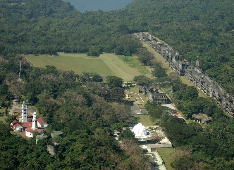
hey fots....since you were prowling the old parade field on topside, you might shed some light on a question that has been nagging at me recently. i posed this question on this board sometime back but received no "relief". here it is....after viewing some of your aerial shots taken of topside, the "mile lone" barracks and the parade grounds, i have the impression, comparing your photos with some from the 1930s, that said field is now smaller in area. it would seem that the undergrowth on the west and southwest parts of the parade ground perimeter have crept eastward. if this is so, i can understand that the maintenance folks have just quit mowing, maintaining, etc, the far western fringes of the former field. do you feel that this is just my mistaken impression or that, in fact, the old regimental parade facility has surrendered, in part, to the ever encroaching jungle?  ? you have to know by now that these bits of trivia are of monumental interest to me and have a direct bearing on my mental health. |
|
|
|
Post by fots2 on Jul 14, 2009 10:18:07 GMT 8
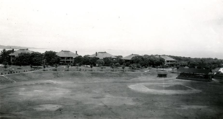
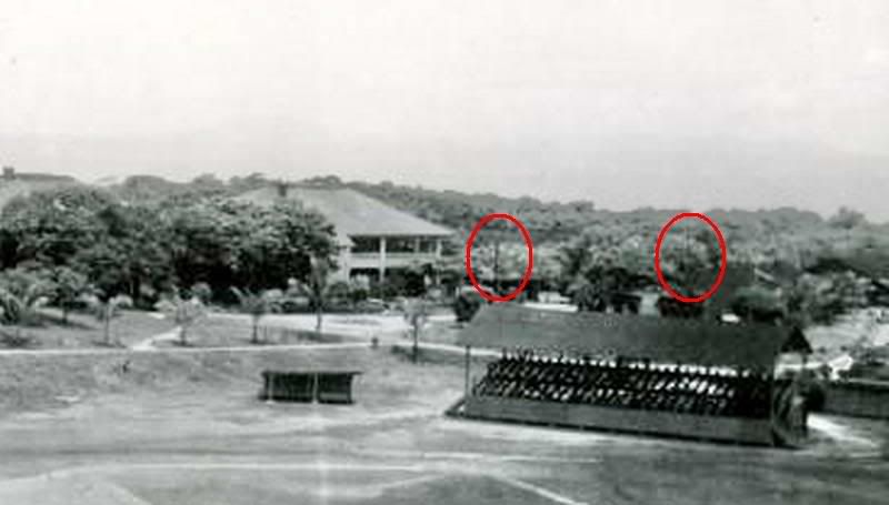
Dan, When I come across the remnants of wooden poles they appear to be both destroyed splinters or have been cut off fairly low to the ground. Today many are wooden circular shells due to their centre’s having rotted away. Honestly they are a walking hazard and I don’t pay much attention to them. By the way, I doubt very much if the pole used for the flag would have been a telegraph pole even though they might have called it that. Telegraph was used for long distance communication but distances on the island are so short that copper wire would have no problem carrying voice or regular telephone calls. Important communication and essential power cables would have been underground. There are many concrete manholes with conduits for buried cables around the island. My guess for the wooden poles is local power lines or non-essential telephone lines to the houses and buildings in the area such as the Senior Officer’s Quarters. Your average Joe probably can’t tell the difference between a power or telegraph pole anyway. Actually, who cares, just my previous working life kicking in.  Sorry I do not know exactly where a pole would be west of the Parade Ground. From where they stop mowing the grass to the tree line can be quite thick grasses but the walking is not too bad. Once into the tree line, walking is good. I think a good place to look for old poles near the western end is along some old roads. Lots of buildings were in this area. There was even a rail line close to the western end of the Parade Ground going to Battery Wheeler but power for that line would have been carried on metal poles.   Actually I do see one pole in the above pre-war photo of the Parade Ground. Zoom in and look above the Grandstand to the left. Perhaps another one to the right of it. This is on the south west side though. I doubt you will ever know exactly which one flew the flag unless someone comes up with a good 1945 photo. I have not seen much for details of utilities on maps. That would be interesting. (Primary power generation was in Engineer Ravine on Bottomside and the Telephone Exchange was on Topside east of the Cine). |
|
|
|
Post by fots2 on Jul 14, 2009 10:22:53 GMT 8
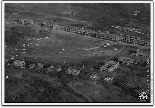
okla, In my humble opinion, the Parade Ground is the same size it has always been with the exception of 20 feet or so of grasses at the western end which was not mowed the last time I looked. It looks good when the areial photo was taken.   Compare my aerial photo with the 1945 jump photo. The western tree line is roughly the same in both of them when compared to the adjacent Mile Long Barracks. It is a little difficult to see from those angles though. My photo is taken from the east so from that perspective, the Parade Ground looks shorter too. Also, why I say the size is the same is that after you walk through the grass, you come to a short steep slope which is the end of level ground and at the start of the tree line. At the bottom of the slope is an amazing concrete drainage system for the Parade Ground. When I first saw it, I thought I had found a new tunnel. It is quite elaborate for just a drain but you can tell that is all it is. If you look at the top photo, you will notice two treed circular areas at the west end of the field. These conceal the drains (water intakes) which feed the tunnel I mentioned. I am sure this drainage system is pre-war. Surrounding the Parade Ground today is the old rail bed and Mile Long Barracks to the north. The Cine, HQ building and Spanish flagpole are to the east. The Senior Officer’s Quarters are to the south. With the abrupt drop-off and drainage system to the west, I think I would be safe in saying that the Parade Ground is still it’s original size. |
|
|
|
Post by okla on Jul 14, 2009 23:09:33 GMT 8
hey fots...again, many thanks for another enlightening "fots tour". obviously my antiquated vision was playing tricks on me. with your able assistance it is also obvious that the parade grounds are just about the same in area as before hostilities started. as i said before, my old intelligence officer in charge always said, " the camera doesnt lie. by the way, in reference to your conversation with the other poster, isnt that baseball diamond located in the southeast corner of the parage field?  ?i conversed with somebody in the recent past about the location of the baseball diamond. it probably had various locations, but the photo just posted seems to be in the southeast corner of said field. correct me if i am in error (which seems to be more frequent as i near 77 years of age). |
|
|
|
Post by fots2 on Jul 14, 2009 23:42:38 GMT 8
Hi okla, You may be right that the baseball diamond had different locations at different times, I really don’t know. I am pretty sure the old photo shows the south west corner for a few reasons: - The coastline of Cavite appears to be fading away in the distance which would not happen is it was a SE view. - We should be able to clearly see the tall Spanish Flagpole if looking SE. - The Senior Officer’s Quarters continue east well past the Parade Ground but in the westerly direction they stop at the SW corner of the Parade Ground as the photo shows. - The 1932 map shows only one grandstand at the SW corner of the Parade Ground. You keep me on my toes…I had to go look again.  Have a good day. |
|
|
|
Post by okla on Jul 15, 2009 2:59:24 GMT 8
hey fots....as usual i am sure you are correct, but what was throwing me is this....aint that hooker point barely visible between the first and second officer's quarters. also, could that be fort hughes, also barely visible, over the third building?  now having said this and having perused my corregidor maps again, i am sure you are correct. i say, again, as my old OIC said, "the camera doesnt lie". the line of quarters are on the first base side and that would, indeed, place the diamond in the southwest corner of the parade ground. that would make that land mass the cavite headland instead of hooker point area. as far as different locations for the baseball field, i am sure that somewhere i saw a team photo with the grandstand and the top side barracks in the background. this would indicate that they probably, over the years, played all over that area. in fact, i saw a map that had the parade ground designated as "athletic field". you could move those old wooden bleachers easily and mark off new basepaths and foul lines with ease. anyhow, i sincerely appreciate my continuing education as pertains to our favorite subject corregidor/bataan. have a cool day. its 102 here in tulsa as we speak (2;00 pm CST), |
|
|
|
Post by EXO on Jul 15, 2009 10:23:21 GMT 8
I was collecting photos of the great game for an upcoming photo essay, " Corregidor style." Seems like an appropriate time to show a few. (Above:) The Ft. Mills team plays Navy - the year is unknown. |
|


 ? you have to know by now that these bits of trivia are of monumental interest to me and have a direct bearing on my mental health.


