|
|
Post by okla on Aug 7, 2009 7:25:31 GMT 8
hey batts....obviously that mitt should be bronzed and displayed, if not at cooperstown, in the philippine baseball hall of fame. i am sure we will be forgiven for deviating into a baseball discussion, but after all, it is the greatest game on the planet. now back to the dismal days of early 1942.
|
|
|
|
Post by EXO on Aug 7, 2009 21:15:10 GMT 8
Getting back on topic, Dan MacRaild has sent us a few pictures of the true flag.
|
|
|
|
Post by EXO on Jun 4, 2010 8:24:30 GMT 8
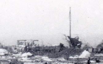
Thanks to A. J. Basso, who is the son of paratrooper Dominick Basso, we now have a photo of Landing Field "A" taken westwards. I have highlighted the telephone pole at the end of the field, and note that towards its top, the image softens and spreads from being just a straight edge. It looks to me like we've found the Arrigo/Bates flag pole. It was under this flagpole that the 2nd Bn patrols would pass each morning as they went on patrol, and under it too that their dead would be carried back in the afternoons. Now, to locate where it was... |
|
|
|
Post by fots2 on Jun 4, 2010 22:58:29 GMT 8
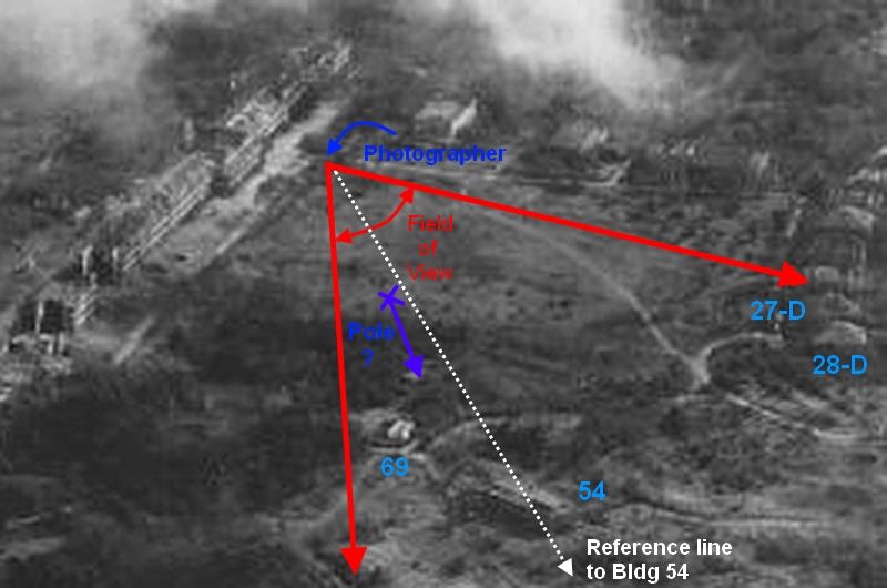
I think the photo that EXO posted shows the view from the south to the western side of the Parade Ground. Map of the area covered in the photo.  (map courtesy of Mapmaster) Unfortunately there are no exact reference points to tell us exactly where the photographer was standing in which to recreate the view. The land along the bottom left to bottom center appears to be above the level of the parade ground. Also the upward slope in the bottom right corner suggests he may have been standing just above the north east corner of the parade ground (i.e. between the road (or on it) and the parade ground). In the tree line to the left you see the most westerly Senior Officers Quarters (27-D and 28-D). The pole appears to be sunk in a pile of gravel at the end of the field or not too far behind the pile. Notice the building to the left of the pole in the following view.  It is the only two story building still standing that you will see when looking in this direction. Normally I would have to guess which building this is but this time I can do better than that. Here is a cropped area of a 1945 pre-invasion photo.  The view is in the opposite direction to the photo that EXO posted. There is only one two story building still standing. The map shows it as being of concrete construction so it makes sense to be still there. Other buildings in the area were wood, galvanized steel or of mixed construction. They appear to have been flattened. Map showing the Parade Ground area of the above photo.  (map courtesy of Mapmaster) Follow the roads on the map from Senior Officers Quarters 28-D to help you identify the buildings seen in the photo. The two story structure is building #54 (NCO Quarters). The white structure at its 10:00 position is the single story concrete building #69 (Radio Station #1). So what does all this tell us? Probably not much more than we already know except I think the pole was near the center at the far end of the field or a little further along that path towards the west. I think it is logical to look in this area first. It is possible that we will find more than one wooden stub sticking out of the ground as there were roads nearby. We may never know which one was the exact pole in the photo. Looking for it is worth a try. |
|
|
|
Post by Jim Mullaney on Jun 5, 2010 6:52:52 GMT 8
Wish I could be of greater help with the flag pole question.
The only flagpole that I recall seeing was the one where the flag was raised when Mac returned to the Island and awarded Col. Jones the DSC.
I"ve been viewing the numerous newsreels on "YOU TUBE" ---- Corregidor 1945 or "Corregidor 503" ..
The flagpole was very near the "H" original assembly point. As we looked over the edge of Topside"..´ It was on our right probably 75 to 100 yards away.
From this assembly area we could look down on the dock areas and the base of Malinta Hill,
Just over the brink of the hill - probably 50 yards down - was a Japanese anti aircraft battery firing away at the planes unloading the troopers of the second pass
The Japanese crew was shirtless and seemed to have no idea we were so close..
About a dozen "H" men opened fire and silenced them.
We were still making use of the assembly point when some men climbed the pole and unfurled 'OLD GLORY"....
Hope Chet or Bill or someone has a better memory then I have...
Jim Mullaney
|
|
|
|
Post by mapmaster on Jun 5, 2010 10:30:23 GMT 8
Hi I've rotated the 1936 Corregidor map so that it can fit under the subject photograph for comparison of possible pole sites (see below). A few thoughts about the subject photograph: - photographer appears to have been on the embankment, possibly just west of the station at the north east corner of the Athletic Ground
- alignment to the pole is north of the end of the embankment along the southern and south western edge of the Athletic Ground
- there are ruined concrete buildings in front of the pole
- there is a larger ruined building to the left (south) of the pole, which looks to be two story
This indicates the area around or maybe to the south of the Radio Station and eastern aerial tower. The aerial tower would have originally been a steel structure. Could it have been replaced with a wooden pole during 1941-42 fighting and hence became the pole for the raising of the first flag in 1945? Batteryboy's image depicts the flag on a fairly substantial pole and a little more substantial than that needed for telephone cables. Given the substantial nature of the pole, perhaps the remains at its base are still evident. Regards mapmaster |
|
|
|
Post by fots2 on Jun 5, 2010 13:07:43 GMT 8
Hi Mapmaster. I agree, this pole is much higher than what is required to suspend a cable beside a road. I am not sure what the reason for this particular pole was, a temporary antenna pole is a good possibility. The antenna system for Radio Station #1 was actually quite an elaborate structure with two metal free standing towers, each one sitting on four concrete pedestals. Your map show a “X” pattern at each end of the suspended antenna cable, these are the pedestals. I found this photo of the Topside Parade Ground. Have a look what is behind the soldiers…  Below is a photo of Radio Station #1 and part of a tower. Mile Long Barracks is in the background.  The Radio Station building and the tower’s concrete pedestals are still there. |
|
|
|
Post by one50 on Jun 6, 2010 9:28:47 GMT 8
You guys simply amaze me. Your knowledge of this island is incredible. I'll be pouring over photos till my trip. I will definitely assist in looking for what may be left of the grand pole on my 2010 visit.
Keep up the good work guys.
Thank you
Dan
|
|
|
|
Post by fots2 on Jun 6, 2010 22:45:05 GMT 8
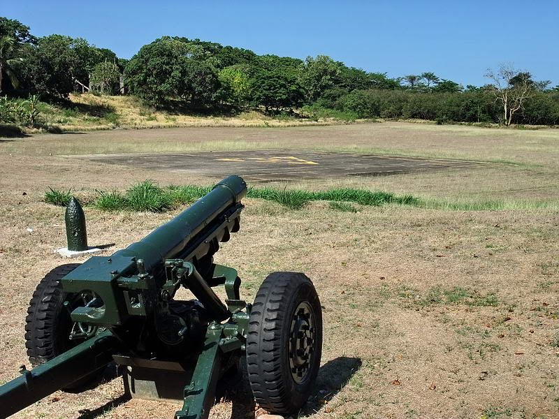
No problem Dan. Next year you can tramp around this area yourself. Here is a view of the Topside Parade Ground taken in May, 2010. My location was similar to where the original 1945 photo was taken but I am looking more south than west as the original photo was. With all the trees the field looks smaller than during wartime. You can see the little slope down to the Parade Ground level is still there. The road is just behind me. Between the trees to the left you can barely make out the corner of one of the Senior Officer’s Quarters.  |
|
|
|
Post by fots2 on Jun 11, 2010 20:35:33 GMT 8
Hi Mapmaster,
That is a good photo with an interesting view of what we will try to find. I agree the right hand pole is a strong possibility. Starting a search near the western end of the Parade Ground seems like the best idea.
|
|