|
|
Post by chadhill on Nov 23, 2010 8:51:34 GMT 8
I came across this photo in "Philippine Expeditionary Force", published by the Japanese in occupied Manila, 1943.  Could this be President Quezon's yacht, the Casiana? The Moore Report simply says it sank on 6 January '42 in Corregidor Bay. According to the Belote brothers in "Corregidor, The Saga of a Fortress", page 102, marines from the 4th Regiment "discovered a rich prize, a stock of whiskey aboard President Quezon's half-sunken yacht, the Casiana...many and mysterious were the deals that followed until the MP's caught on". Here are two undated photos of the Casiana that an internet search turned up. It looks like it had a few deck mods done to it at some point. Does anyone know how or why it sank?   |
|
|
|
Post by okla on Nov 23, 2010 10:12:15 GMT 8
Hey Chad...Methinks you are on to something here. That wreck certainly resembles the pic of the vessel after those modifications (2nd photo) were completed. That bridge structure on the wreck and what appears on the slick yacht appear very similar, if not exactly the same. They both seem (to my untrained eye) to be circular in design The fact that the yacht is only partially under water near Corregidor would make it awfully easy for enterprising "gyrenes" to salvage some of the El Presidente's private stock. This is an intriguing post. I hope the real "skinny" surfaces. This is exactly the kind of thing that runs me nuts and jump starts my over active imagination. Cheers.
|
|
|
|
Post by batteryboy on Nov 23, 2010 21:15:31 GMT 8
Yes, that is the Casiana. Majority of the ships parts are still there.
|
|
|
|
Post by okla on Nov 23, 2010 22:31:51 GMT 8
Hey Battery....Thanks for the info. I can now search for something else to fret over. Cheers.
|
|
|
|
Post by chadhill on Nov 29, 2010 1:21:31 GMT 8
Found some more things: Note the white rectangular building to the right of the Casiana in the lower photo above. This looks like the Marsman Building in Manila (is it still there?) where the HQ of Admiral Thomas Hart, C-in-C Asiatic Fleet, was located. Interestingly, the Canadian Pacific railroad shared office space (see letters on building). It owned a shipping line which provided service between Vancouver and Victoria, British Columbia to Hong Kong during 1887-1941 with stops in Manila, Japan and China. The Marsman Building was even air conditioned, according to the caption to this photo from "Battle Report, Pearl Harbor to Coral Sea", 1944.  Here is another pic from the same book:  Enlarged area:  I was struck by the similarity and location of the ship in this photo and in the PEF photo. I remembered that in another thread Batteryboy pointed out that he thought the ship in this photo could be the Casiana, too. From what I can tell, the stack and masts of this partially sunken ship resemble the Casiana's, and it could also be in "Corregidor Bay". The cliffs on the shoreline to the left look similar to the cliffs in the PEF photo. I think these are the cliffs at Battery Point. Although the ship is more submerged and is at a different angle here than in the PEF photo, it could have shifted. I don't see the PEF photo's breakwater line of rocks here, either, unless the enlarged pic shows what could be a possible trace of the rock tops near the right edge of the photo. The PEF photo looks to me like it was taken from North Dock or Engineer Dock. If so, the dock could be blocking the rocks from view in this photo. Was there another wreck in this area? "Saga", on page 102, mentions a barge named the Barleycorn, which sank in 10 feet of water, but this one doesn't strike me as looking like a barge. If this photo is the partially sunken Casiana, for it to have been published in a wartime US book it would have had to been smuggled off Corregidor before the May 6, 1942 surrender. Yet a post-surrender Japanese PEF photo shows it being less submerged! That makes me think the PEF photo was taken first by USFIP forces, found by the Japanese on Corregidor after the surrender, and published in their book. The "Battle Report" photo was taken later, after the ship slid further away from the beach and sank deeper. Just my hunch...stranger than fiction? |
|
|
|
Post by okla on Nov 29, 2010 7:23:56 GMT 8
Hey Chad....The photo showing only the masts and stack also shows the docking area with little or no bombing or shelling damage. If that vessel is the Presidential Yacht, this pic must have been taken shortly after January 6, 1942, before this area started to be pounded almost daily from the air and certainly before shelling, especially from newly occupied Bataan increased the abuse the island suffered. Also, couldn't this photo been taken at high tide? Of course, I don't have an inkling about the nature of the tides in Manila Bay and how they run. That boat might have shifted position almost daily for all I know. Seems logical to me, though. Little riddles, such as this, run me nuts, but I love it. Cheers.  |
|
|
|
Post by chadhill on Nov 29, 2010 8:25:25 GMT 8
You always raise good points, Okla! Does anybody out there know about the tides? Might that explain the missing breakwater rock line in the photo? I can see the tides moving the ship further from the shore as it sinks, little by little. Or, could it be that after those gyrenes "rescued" the whiskey stock from the Casiana that it lost all anchorage and drifted away?  Here's a pic I took in '86 showing North Dock and Engineer Dock (during high tide?). I wonder when that big chunk was taken out of North Dock, close to where the crane would be in the "Battle Report" picture? It would be great if someone could post an early wartime photo for comparison.  |
|
|
|
Post by chadhill on Nov 29, 2010 9:37:50 GMT 8
You got me scratching my noggin again, Okla. I'm still thinking the PEF photo was taken before the "Battle Report" photo. PEF shows the ship closer to Battery Point, and higher in the water. "Battle Report" has it further away, with all decks below water. Methinks it would take pretty hefty tides to drive it closer to Battery Point with all that H2O on board.
But then, was there a typhoon near Manila in '42 or '43?
Like you brought up, a battle damage photo of North Dock between January 6 - May 6, '42 would be very helpful.
P.S.--my wife has been looking over my shoulder this afternoon and thinks I'm a Section Eight case.
|
|
|
|
Post by fots2 on Nov 29, 2010 18:49:34 GMT 8
Hi Chad, Looking at one of the local weather forecasting sites here, I see that the difference between high and low tides today is 0.71m (or 2.3 feet). The big chunk out of North Dock occurred sometime before the 1945 February 16, 1945 invasion day. 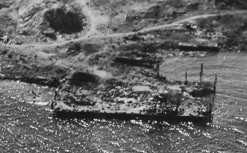 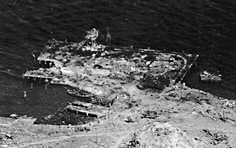 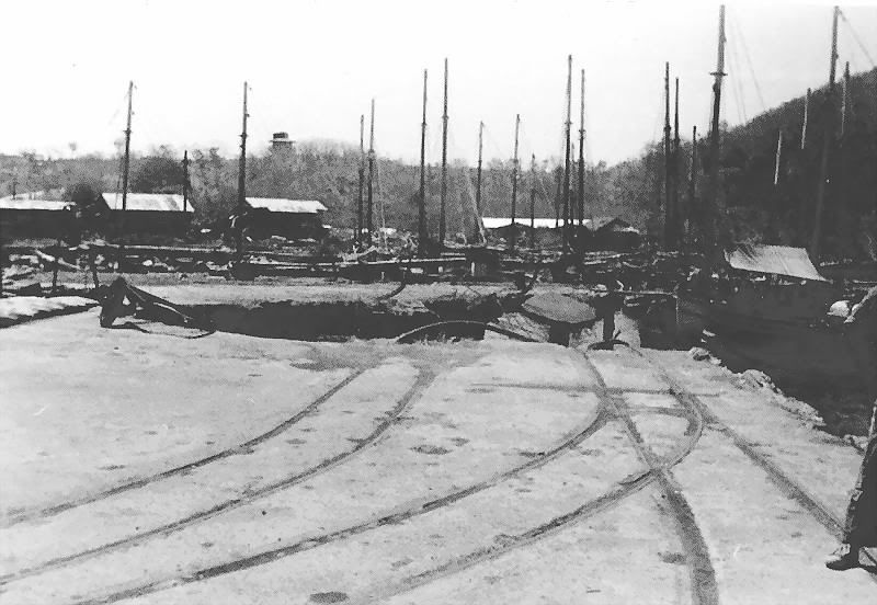 Those are very good photos you have been posting lately. Get your wife to call okla’s wife. They have something in common to talk about. ;D |
|
|
|
Post by okla on Nov 29, 2010 22:36:15 GMT 8
Hey Fots....As I remember, you stated in the past that your wife has given you a few questioning glances, but maybe she is more tolerant due to her understanding of your addiction. Her greatest fear is probably being notified by the authorities that you are lost somewhere in one of the "uncharted" Navy Tunnels. ;D
|
|


