|
|
Post by chadhill on Nov 30, 2010 11:48:46 GMT 8
Okla  good comeback! I can't top it...anyways- Great photos (as always), fots! I'm going to file them away for future study, there is an incredible amount of detail there. I spent some time this afternoon looking them over and digging around my library for info that would give a rough date when the "Battle Report" photo was taken, but didn't have any luck yet. Thanks for supplying the tide data. I didn't see a breakwater in any of the North Dock photos, but just to the west (right) of Engineer Dock in the aerial photo there might be the short remains of one. If you look near Battery Point in the "Battle Report" photo there could be one also. I did find this undated photo of the Casiana taken from just off the beach:  Here the Casiana is close to the shore as in the PEF pic, but nearly submerged as in the "Battle Report" photo. (The ship at the bottom right is the inter-islander La Florecita). My SWAG (scientific wild-arse guess) is that on January 6th, for some reason unknown to us at this time, the Casiana partially sank close to Battery Point. Someone on the damaged Engineer Dock took the PEF photo. While she was still mostly above water, the USMC ensured that her precious cargo was safely recovered (for the good of the Corps, of course). The Casiana sank deeper, when the above picture was taken. It gradually slipped further away from the shore due to tides and currents, when the BR photo was taken. After securing Corregidor, the Japanese found the PEF photo and recognised it was President Quezon's yacht. For propaganda purposes they included it in the book. ...I am heading towards section 8...if I can get my wife to join me with Mr. and Mrs. Okla on Corregidor, then link up with Mr. and Mrs. Fots2, we can all tour the island for some therapy... ;D |
|
|
|
Post by okla on Nov 30, 2010 23:03:43 GMT 8
Hey Chad....Now that's the type therapy that I can go for. Also, did you ever learn thru "back channels" (haven't seen anything posted as yet) if the Marsman Building is still in existence??? Not knowing where it was located in the City of Manila, I couldn't guess what it's fate might have been. I do know that the big, heavy duty fighting took place south of the Pasig River. The way I understand it, that area of the "Jewel of the Orient" suffered extensive damage so if said establishment was in the southern region of Manila it may have been pummeled into rubble. The structure looks solid as a rock in the peace time photos so it might have withstood the 1945 battering and was worth patching up. Surely Fots, EXO,Phantom, Battery or Karl can clue us in. You may have walked right past it in your PI tour of duty and never realized the significance of the joint. Cheers.
|
|
|
|
Post by fots2 on Dec 1, 2010 22:51:34 GMT 8
Hi okla,
I have been away for a few days and just saw your comments. Actually the wife can fully understand an ‘addiction’. Hers is called “facebook”. ;D
I like your idea of “uncharted” Navy Tunnel. I’ll pass on the first part though.
Sorry I never heard of the Marsman Building before. I may have passed it but I have no idea where it is supposed to be. Looks impressive. Maybe the others can help.
|
|
Deleted
Deleted Member
Posts: 0
|
Post by Deleted on Dec 2, 2010 1:54:55 GMT 8
The Marsman is still there, on Muelle de San Francisco and 23rd st. Although it appears to have lost that beautiful Art Deco Exterior and now sports a red roof.
|
|
|
|
Post by okla on Dec 2, 2010 2:24:26 GMT 8
Hey Tiyo...Thanks for the update. Maybe some good soul will post a photo of the "new" Marsman. Cheers.
|
|
|
|
Post by okla on Dec 2, 2010 7:34:43 GMT 8
Hey Chad....Do you think that the horrific typhoon, described in Phantom's latest installment of "Captured on Corregidor", might have had something to do with the final positioning or "repositioning" of President Quezon's yacht??? If the hulk was still a bit buoyant, a "blow" as extensive as this one was said to be, could have placed the old gal in her final resting place,etc. Whatcha think?  This is, after all, an earth shaking problem and we must find the final answer or turn it over to the United Nations. Cheers. |
|
Deleted
Deleted Member
Posts: 0
|
Post by Deleted on Dec 3, 2010 9:24:44 GMT 8
Found this from Google Earth / Panoramio. If you look carefully, you can just make out the columned façade. It also looks like a fifth floor was added.  |
|
|
|
Post by okla on Dec 3, 2010 22:25:22 GMT 8
Hey Tiyo....Thanks for digging up the updated shot of the Marsman. It has, indeed, been vastly remodeled,etc. I suppose it really took a beating during the liberation fight in 1945. Probably a Japanese strongpoint since it undoubtedly was one of the more substantial structures in the neighborhood. I am impressed with the changes that have been made. Probably most of the people located there have no idea of what went on there in the early hours of Dec 8, 1941. Cheers.
|
|
|
|
Post by chadhill on Feb 1, 2014 11:56:04 GMT 8
I recently came across this photo of an A-20 Havoc bombing raid on Corregidor in February 1945, and something in it caught my eye. 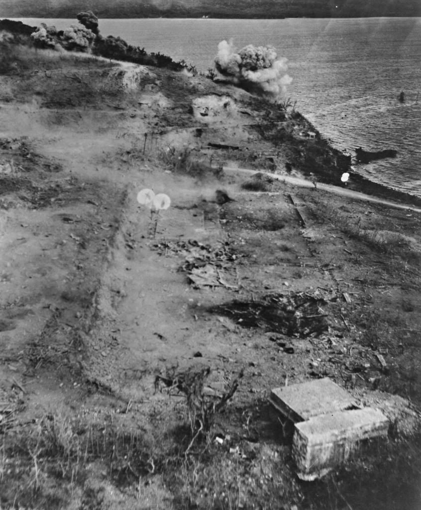 Note that in the upper right corner, a short distance off shore, a stack and a mast resembling the Casiana's can be faintly seen. (The wreckage of another ship, nearly run aground on the beach, can also be seen. Could this be the barge Barleycorn mentioned by the Belote's on p. 102 of "Saga of a Fortress"?) Here is a cropped enlargement of that section:  The Bataan shore can be seen in the far background of the top photo. I wondered if this photo had been taken looking north towards Battery Point, where the Casiana had sank in January 1942. I checked the 1936 Corregidor map. Here is a section from the map:  The map shows two 75mm positions. The photo, above the road and near the shoreline, shows a concrete structure with legs and a rectangular roof which resembles the 75mm shelters seen on top of Malinta Hill. But it seems closer to the shoreline than the map indicates. The map also shows another structure, S.M.S.H. No. 6, just south of the road. According to the 1936 map legend (not shown here), the accompanying boxed "x" symbol means "Privately Owned", if I am not mistaken. In the top photo, just below the road and immediately to the right of the two white parachutes, the remains of a building foundation can be seen. Could that be S.M.S.H. No. 6? I wonder what this structure was. I do not know what VII-M-3 is, seen just above the road and immediately north of S.M.S.H. No.6. on the map. There could be foundation ruins in the top photo at this location, but I am not sure. The two concrete blockhouses at the bottom of the top photo are not seen on the 1936 map. A hunch is that nine years had passed since the map was surveyed and maybe they had been built during that time. Just another SWAG... |
|
|
|
Post by fots2 on Feb 2, 2014 0:02:36 GMT 8
Hi Chad, That is an excellent photo. Thanks for posting it. I can help you with the area in view. On the 1936 map at the old Stockade area, look for building #207. That is the “two concrete blockhouses” seen at bottom right. Actually they are one structure and it still exists today. Use it as a reference point to look in a northerly direction approximately 325 degrees. Many items seen in the photo can now be identified with the help of the map. The Engineer Dock is just out of sight to the right. When I have some time I can label some things for you if you wish. Do you have a better resolution version of this photo that you could send to me? Here is a look at building #207. 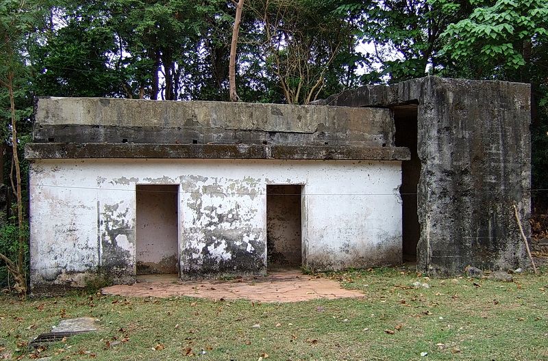 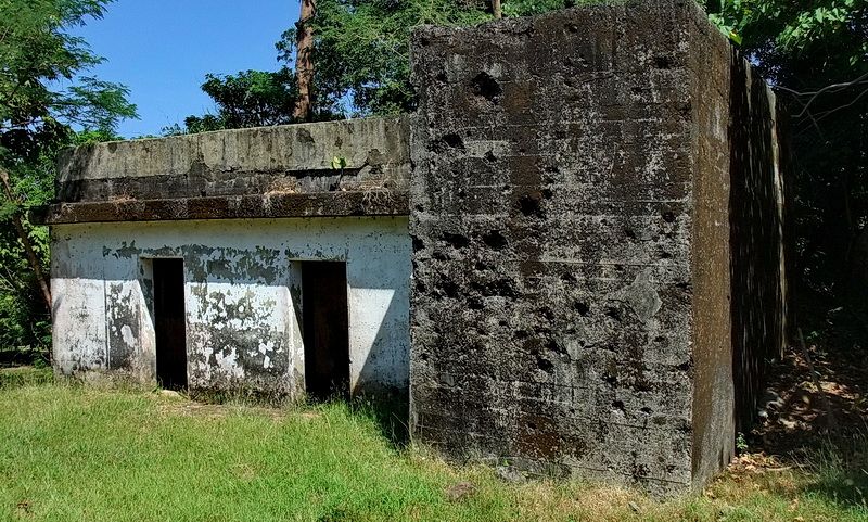 |
|


 good comeback! I can't top it...anyways-


 This is, after all, an earth shaking problem and we must find the final answer or turn it over to the United Nations. Cheers.


